
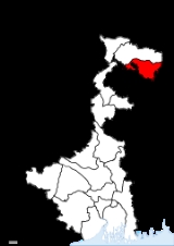
Cooch Behar District
Encyclopedia
Cooch Behar district is a district of the state of West Bengal
, India
, as well as the district's namesake town. During the British Raj
, the town of Cooch Behar was the seat of a princely state
of Koch Bihar
, ruled by the Koch dynasty.
As of 2011 it is the third least populous district of West Bengal (out of 19
), after Dakshin Dinajpur and Darjeeling
.
word "Bihar" (to travel) which means the land through which the "Koch Rajbongshi" Kings used to travel or roam about ("Bihar").
The greatest Koch Rajbongshi King that has ever ruled in the Kingdom of Kamatapur is Maharaj Naranarayan, as well as his younger brother Prince Chilaray and other descendents.
Historic Kamatapur comprises the total North Bengal maximum parts of Assam, some parts of present Bangladesh, Kishanganj district of Bihar and a few parts of Bhutan. The Koch-Rajbongshi community is demanding a separate state of their own comprising the parts of their old Kingdom to save their centuries-old culture from extinction.
originated from Mahishya community and has ruled the area around the town of Cooch Behar since the 16th century. The state remained unaffected by the great changes that overtook its surrounding provinces in the decade following the Battle of Plassey
in 1757. However, it was invaded by Bhutan
in the latter half of the 18th century, which prompted a British Ambassador to Bhutan, George Bogle
to enter into a formal treaty alliance with the British
in 1775. In 1947, the state acceded to the dominion of India
and merged with the Union of India shortly afterwards.
Over time, Cooch Behar has been transformed from a kingdom to a state and from a state to the present status of a district. Before 28 August 1949, Cooch Behar was a Princely state ruled by the king of Cooch Behar, who had been a feudatory ruler under the British Government. By an agreement dated 28 August 1949 the king of Cooch Behar ceded full and extensive authority, jurisdiction and power of the state to the Dominion Government of India
. The transfer of administration of the state to the Government of India came into force on 12 September 1949. Eventually, Cooch Behar was transferred and merged with the province of West Bengal
on 19 January 1950 and from that date Cooch Behar emerged as a new District in the administrative map of West Bengal.
 Cooch Behar is a district under the Jalpaiguri
Division of the state of West Bengal. Cooch Behar is located in the northeastern part of the state and bounded by the district of Jalpaiguri in the north, state of Assam
in the east and by Bangladesh
in the west as well as in the south. The district forms part of the Himalayan Terai
of West Bengal.
A geopolitical curiosity is that there are 92 Bangladeshi exclaves, with a total area of 47.7 km² in Cooch-Behar. Similarly, there are 106 Indian exclaves inside Bangladesh, with a total area of 69.5 km². These were part of the high stake card or chess games centuries ago between two regional kings, the Raja of Cooch Behar and the Maharaja of Rangpur.
Twenty-one of the Bangladeshi exclaves are within Indian exclaves, and three of the Indian exclaves are within Bangladeshi exclaves. The largest Indian exclave, Balapara Khagrabari, surrounds a Bangladeshi exclave, Upanchowki Bhajni, which itself surrounds an Indian exclave called Dahala Khagrabari, of less than one hectare (link to external map here). See also Indo-Bangladesh enclaves
.
The rivers in the district of Cooch Behar generally flow from northwest to southeast. Six rivers that cut through the district are the Teesta
, Jaldhaka, Torsha, Kaljani, Raidak, Gadadhar and Ghargharia.
and tobacco
. Paddy rice
is also grown before and after the rainy season. Common plantation crops are arecanut, coconut
and black pepper
. Vegetable, mustard plant
, and potato
cultivation are increasing. In order to support agriculture, special programs have been taken for the production of sunflower
s, maize
and groundnut
s. Revolutionary methods are being used in Boro paddy and potato cultivation. But due to nonadoption of modern technology, a large number of farmers still depend on traditional technology. Only 33% of the potentially cultivable land is developed for irrigation. In Kharif, the area of production of vegetables and other crops is much less. The ovine breed in the region originates from Tibet and was brought to the plains of West Bengal by traders. The trade between Tibetan traders and traders from the plains of Bengal took place from the region. The sheep along with other items of trade were transported to a place known as Bhot Patti (situated in Maynaguri Block of Jalpaiguri District). The major trading occurred at a place known as Rangpur, situated now in Bangladesh. The goods were exchanged and the sheep were also taken to plains of Bengal by the returning traders, the animals were given to the farmers of Sunderban region for rearing and bringing them back to their health. The sheep were used for their meat by the Europeans during the colonial era. They preferred mutton over Chevon so sheep meat was in great demand. A single consignment of the sheep were transported to Australia in the late 18th century when the Australian colony was being settled. The consignment was shipped from the port of Fulta near Kolkata. However, the sheep were not preferred by the settlers as their size was small and wool quality too was inferior. The breed Booroola Merino of Australia are the descendents of the same sheep.
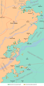
municipality and two community development blocs: Cooch Behar–I and Cooch Behar–II. Dinhata subdivision consists of Dinhata
municipality and three community development blocs: Dinhata–I, Dinhata–II and Sitai. Mathabhanga subdivision consists of Mathabhanga
municipality and three community development blocs: Sitalkuchi, Mathabhanga–I and Mathabhanga–II. Mekhliganj subdivision consists of Mekhliganj municipality and Haldibari
municipality and two community development blocs: Mekhliganj and Haldibari. Tufanganj subdivision consists of Tufanganj
municipality and two community development blocs: Tufanganj–I and Tufanganj–II. Cooch Behar
is the district headquarters. There are 11 police stations, 12 development blocks, 6 municipalities and 128 gram panchayat
s in this district.
Other than municipality area, each subdivision contains community development blocs which in turn are divided into rural areas and census towns. In total there are 10 urban units: 6 municipalities and 4 census towns. Cooch Behar
, Kharimala Khagrabari
and Guriahati
are part of a urban agglomeration. Dinhata
and Bhangri Pratham Khanda
also form an urban agglomeration together.
Mekliganj, Sitalkuchi, Mathabhanga and Tufanganj constituencies are reserved for Scheduled Castes (SC) candidates. Mekhliganj constituency is part of Jalpaiguri (Lok Sabha constituency)
, which also contains six assembly segments from Jalpaiguri district
. Sitalkuchi, Mathabhanga, Cooch Behar North, Cooch Behar West, Sitai, Dinhata and Natabari constituencies form the Cooch Behar (Lok Sabha constituency)
, which is reserved for Scheduled Castes (SC). Tufanganj constituency is part of Alipurduars (Lok Sabha constituency)
, which also contains six assembly segments from Jalpaiguri district
.
Mekliganj, Mathabhanga, Cooch Behar Uttar, Sitalkuchi and Sitai constituencies will be reserved for Scheduled Castes (SC) candidates. Mekhliganj constituency will remain part of Jalpaiguri (Lok Sabha constituency)
, which will also contain six assembly segments from Jalpaiguri district
. Mathabhanga, Cooch Behar Uttar, Cooch Behar Dakshin, Sitalkuchi, Sitai, Dinhata and Natabari constituencies will continue to form the Cooch Behar (Lok Sabha constituency)
, which will be reserved for Scheduled Castes (SC). Tufanganj constituency will remain a part of Alipurduars (Lok Sabha constituency)
, which will also contain six assembly segments from Jalpaiguri district
.

Apart from these other tourist spots are:
Cooch Behar district has a population
of 2,822,780, roughly equal to the nation of Jamaica
or the US state of Kansas
. This gives it a ranking of 136th in India (out of a total of 640
). The district has a population density of 833 PD/sqkm . Its population growth rate
over the decade 2001-2011 was 13.86 %. Koch Bihar has a sex ratio
of 942 females
for every 1000 males, and a literacy rate
of 75.49 %.
In absence of large forest area in the district, except at Patlakhawa, not many species of animal are found though there are many wildlife sanctuaries, national parks and animal reserves in the neighboring Jalpaiguri
district and Alipurduar
subdivision of Jalpaiguri which are not very far from the district.
In 1976 Cooch Behar district became home to the Jaldapara Wildlife Sanctuary, which has an area of 217 square kilometre. It shares the park with Jalpaiguri district
.
Primary Schools - 1805
High Schools - 120
Higher Secondary Schools - 61
High Madrasa - 5
Senior Madrasa - 2
Junior High School - 60
Junior High Madrasa - 16
Kendriya vidyalaya - 1
Engineering / Technical Schools - 2
Professional & Technical Schools - 16
General College - 9
Blind School - 1
Libraries - 110
Cooch Behar district has an Agricultural University named Uttar Banga Krishi Viswavidyalaya at Pundibari about 15 km from Cooch Behar Town. Apart from those Government schools there are a few privately aided schools mostly ICSE, ISC and CBSE boards.
West Bengal
West Bengal is a state in the eastern region of India and is the nation's fourth-most populous. It is also the seventh-most populous sub-national entity in the world, with over 91 million inhabitants. A major agricultural producer, West Bengal is the sixth-largest contributor to India's GDP...
, India
India
India , officially the Republic of India , is a country in South Asia. It is the seventh-largest country by geographical area, the second-most populous country with over 1.2 billion people, and the most populous democracy in the world...
, as well as the district's namesake town. During the British Raj
British Raj
British Raj was the British rule in the Indian subcontinent between 1858 and 1947; The term can also refer to the period of dominion...
, the town of Cooch Behar was the seat of a princely state
Princely state
A Princely State was a nominally sovereign entitity of British rule in India that was not directly governed by the British, but rather by an Indian ruler under a form of indirect rule such as suzerainty or paramountcy.-British relationship with the Princely States:India under the British Raj ...
of Koch Bihar
Koch Bihar
Koch Bihar was a small kingdom located south of the Himalayan kingdom of Bhutan, west of the upper Brahmaputra valley Ahom kingdom, and north-east of the Ganges plain and Bengal. It was formed when the Kamata Kingdom under the Koch dynasty split following the death of Nara Narayan in 1586. The...
, ruled by the Koch dynasty.
As of 2011 it is the third least populous district of West Bengal (out of 19
Districts of West Bengal
The Indian state of West Bengal borders with Nepal, Bhutan, Bangladesh and the Indian states of Bihar, Jharkhand, Orissa, Assam and Sikkim. The Himalayas lies in the north of the state and the Bay of Bengal is at the south. In between them, the river Ganges flows eastwards and its main...
), after Dakshin Dinajpur and Darjeeling
Darjeeling district
Darjeeling District is the northernmost district of the state of West Bengal in eastern India in the foothills of the Himalayas. The district is famous for its beautiful hill stations and Darjeeling tea. Darjeeling is the district headquarters...
.
Origin of name
The name "Cooch-Behar" is derived from the name of the Koch Rajbongshi tribe that is indigenous to this area. The word "Behar" is the SanskritSanskrit
Sanskrit , is a historical Indo-Aryan language and the primary liturgical language of Hinduism, Jainism and Buddhism.Buddhism: besides Pali, see Buddhist Hybrid Sanskrit Today, it is listed as one of the 22 scheduled languages of India and is an official language of the state of Uttarakhand...
word "Bihar" (to travel) which means the land through which the "Koch Rajbongshi" Kings used to travel or roam about ("Bihar").
The greatest Koch Rajbongshi King that has ever ruled in the Kingdom of Kamatapur is Maharaj Naranarayan, as well as his younger brother Prince Chilaray and other descendents.
Historic Kamatapur comprises the total North Bengal maximum parts of Assam, some parts of present Bangladesh, Kishanganj district of Bihar and a few parts of Bhutan. The Koch-Rajbongshi community is demanding a separate state of their own comprising the parts of their old Kingdom to save their centuries-old culture from extinction.
History
The Koch dynastyKoch dynasty
The Koch dynasty of Assam and Bengal, named after the Koch tribe, emerged as the dominant ruling house in the Kamata kingdom in 1515 after the fall of the Khen dynasty in 1498...
originated from Mahishya community and has ruled the area around the town of Cooch Behar since the 16th century. The state remained unaffected by the great changes that overtook its surrounding provinces in the decade following the Battle of Plassey
Battle of Plassey
The Battle of Plassey , 23 June 1757, was a decisive British East India Company victory over the Nawab of Bengal and his French allies, establishing Company rule in South Asia which expanded over much of the Indies for the next hundred years...
in 1757. However, it was invaded by Bhutan
Bhutan
Bhutan , officially the Kingdom of Bhutan, is a landlocked state in South Asia, located at the eastern end of the Himalayas and bordered to the south, east and west by the Republic of India and to the north by the People's Republic of China...
in the latter half of the 18th century, which prompted a British Ambassador to Bhutan, George Bogle
George Bogle
George Bogle is a minister and religious broadcaster in Detroit. Bogle is noteworthy for his broadcasting and social activism in Detroit...
to enter into a formal treaty alliance with the British
British East India Company
The East India Company was an early English joint-stock company that was formed initially for pursuing trade with the East Indies, but that ended up trading mainly with the Indian subcontinent and China...
in 1775. In 1947, the state acceded to the dominion of India
Dominion of India
The Dominion of India, also known as the Union of India or the Indian Union , was a predecessor to modern-day India and an independent state that existed between 15 August 1947 and 26 January 1950...
and merged with the Union of India shortly afterwards.
Over time, Cooch Behar has been transformed from a kingdom to a state and from a state to the present status of a district. Before 28 August 1949, Cooch Behar was a Princely state ruled by the king of Cooch Behar, who had been a feudatory ruler under the British Government. By an agreement dated 28 August 1949 the king of Cooch Behar ceded full and extensive authority, jurisdiction and power of the state to the Dominion Government of India
India
India , officially the Republic of India , is a country in South Asia. It is the seventh-largest country by geographical area, the second-most populous country with over 1.2 billion people, and the most populous democracy in the world...
. The transfer of administration of the state to the Government of India came into force on 12 September 1949. Eventually, Cooch Behar was transferred and merged with the province of West Bengal
West Bengal
West Bengal is a state in the eastern region of India and is the nation's fourth-most populous. It is also the seventh-most populous sub-national entity in the world, with over 91 million inhabitants. A major agricultural producer, West Bengal is the sixth-largest contributor to India's GDP...
on 19 January 1950 and from that date Cooch Behar emerged as a new District in the administrative map of West Bengal.
Geography
Jalpaiguri
Jalpaiguri is a city in the state of West Bengal, India. It is the headquarters of Jalpaiguri district, and the divisional headquarters of the North Bengal region.-History:...
Division of the state of West Bengal. Cooch Behar is located in the northeastern part of the state and bounded by the district of Jalpaiguri in the north, state of Assam
Assam
Assam , also, rarely, Assam Valley and formerly the Assam Province , is a northeastern state of India and is one of the most culturally and geographically distinct regions of the country...
in the east and by Bangladesh
Bangladesh
Bangladesh , officially the People's Republic of Bangladesh is a sovereign state located in South Asia. It is bordered by India on all sides except for a small border with Burma to the far southeast and by the Bay of Bengal to the south...
in the west as well as in the south. The district forms part of the Himalayan Terai
Terai
The Terai is a belt of marshy grasslands, savannas, and forests located south of the outer foothills of the Himalaya, the Siwalik Hills, and north of the Indo-Gangetic Plain of the Ganges, Brahmaputra and their tributaries. The Terai belongs to the Terai-Duar savanna and grasslands ecoregion...
of West Bengal.
A geopolitical curiosity is that there are 92 Bangladeshi exclaves, with a total area of 47.7 km² in Cooch-Behar. Similarly, there are 106 Indian exclaves inside Bangladesh, with a total area of 69.5 km². These were part of the high stake card or chess games centuries ago between two regional kings, the Raja of Cooch Behar and the Maharaja of Rangpur.
Twenty-one of the Bangladeshi exclaves are within Indian exclaves, and three of the Indian exclaves are within Bangladeshi exclaves. The largest Indian exclave, Balapara Khagrabari, surrounds a Bangladeshi exclave, Upanchowki Bhajni, which itself surrounds an Indian exclave called Dahala Khagrabari, of less than one hectare (link to external map here). See also Indo-Bangladesh enclaves
Indo-Bangladesh enclaves
The Indo-Bangladesh enclaves, also known as the chitmahals are the enclaves along the Bangladesh–India border, in Bangladesh and the Indian state of West Bengal....
.
Soil
Being the district near the Eastern Himalayan foothills, after rains in the catchment area of each of the rivers generally attain strong current and flood the adjacent area. The turbulent water carries sand, silt, pebbles which causes many problems in productivity as well as hydrology. The soil is formed by alluvial deposits and is acidic in nature. It is friable loam to sandy loam ranging in depth from 0.15 to 1 meter. The soil has a low level of nitrogen while potassium and phosphorus levels are medium. Deficiency of zinc, calcium, magnesium and sulphur is quite high.Rivers and topography
Cooch Behar is a flat country with a slight southeastern slope along which the main rivers of the district flow. Most of the highland areas are in the Sitalkuchi region and most of the low-lying lands lie in Dinhata region.The rivers in the district of Cooch Behar generally flow from northwest to southeast. Six rivers that cut through the district are the Teesta
Teesta River
River Teesta or Tista is said to be the lifeline of the Indian state of Sikkim, flowing for almost the entire length of the state and carving out verdant Himalayan temperate and tropical river valleys. The emerald-coloured river then forms the border between Sikkim and West Bengal before joining...
, Jaldhaka, Torsha, Kaljani, Raidak, Gadadhar and Ghargharia.
Climate
The district of Cooch Behar has a moderate type of climate characterised by heavy rainfall during the monsoon and slight rainfall in the month of October to mid-November. The district does not have high temperatures at any time of the year. The summer season is from April to May with April being the hottest month with mean daily maximum of 32.5 °C and mean daily minimum of 20.2 °C. The winter season lasts from late November to February, with January being the coldest month with temperature ranging from 10.4 °C to 24.1 °C. The recorded temperature minimum is 3.9 °C and respective recorded maximum is 39.9 °C. The atmosphere is highly humid throughout the year, except the period from February to May, when the relative humidity is as low as 50 to 70%. The rainy season lasts from June to September. The district's average annual rainfall is 3 201 mm.Agriculture
The agricultural area of Cooch Behar is 2530.63 square kilometers. The dominant agricultural products of Cooch Behar district are juteJute
Jute is a long, soft, shiny vegetable fibre that can be spun into coarse, strong threads. It is produced from plants in the genus Corchorus, which has been classified in the family Tiliaceae, or more recently in Malvaceae....
and tobacco
Tobacco
Tobacco is an agricultural product processed from the leaves of plants in the genus Nicotiana. It can be consumed, used as a pesticide and, in the form of nicotine tartrate, used in some medicines...
. Paddy rice
Rice
Rice is the seed of the monocot plants Oryza sativa or Oryza glaberrima . As a cereal grain, it is the most important staple food for a large part of the world's human population, especially in East Asia, Southeast Asia, South Asia, the Middle East, and the West Indies...
is also grown before and after the rainy season. Common plantation crops are arecanut, coconut
Coconut
The coconut palm, Cocos nucifera, is a member of the family Arecaceae . It is the only accepted species in the genus Cocos. The term coconut can refer to the entire coconut palm, the seed, or the fruit, which is not a botanical nut. The spelling cocoanut is an old-fashioned form of the word...
and black pepper
Black pepper
Black pepper is a flowering vine in the family Piperaceae, cultivated for its fruit, which is usually dried and used as a spice and seasoning. The fruit, known as a peppercorn when dried, is approximately in diameter, dark red when fully mature, and, like all drupes, contains a single seed...
. Vegetable, mustard plant
Mustard plant
Mustards are several plant species in the genera Brassica and Sinapis whose small mustard seeds are used as a spice and, by grinding and mixing them with water, vinegar or other liquids, are turned into the condiment known as mustard or prepared mustard...
, and potato
Potato
The potato is a starchy, tuberous crop from the perennial Solanum tuberosum of the Solanaceae family . The word potato may refer to the plant itself as well as the edible tuber. In the region of the Andes, there are some other closely related cultivated potato species...
cultivation are increasing. In order to support agriculture, special programs have been taken for the production of sunflower
Sunflower
Sunflower is an annual plant native to the Americas. It possesses a large inflorescence . The sunflower got its name from its huge, fiery blooms, whose shape and image is often used to depict the sun. The sunflower has a rough, hairy stem, broad, coarsely toothed, rough leaves and circular heads...
s, maize
Maize
Maize known in many English-speaking countries as corn or mielie/mealie, is a grain domesticated by indigenous peoples in Mesoamerica in prehistoric times. The leafy stalk produces ears which contain seeds called kernels. Though technically a grain, maize kernels are used in cooking as a vegetable...
and groundnut
Peanut
The peanut, or groundnut , is a species in the legume or "bean" family , so it is not a nut. The peanut was probably first cultivated in the valleys of Peru. It is an annual herbaceous plant growing tall...
s. Revolutionary methods are being used in Boro paddy and potato cultivation. But due to nonadoption of modern technology, a large number of farmers still depend on traditional technology. Only 33% of the potentially cultivable land is developed for irrigation. In Kharif, the area of production of vegetables and other crops is much less. The ovine breed in the region originates from Tibet and was brought to the plains of West Bengal by traders. The trade between Tibetan traders and traders from the plains of Bengal took place from the region. The sheep along with other items of trade were transported to a place known as Bhot Patti (situated in Maynaguri Block of Jalpaiguri District). The major trading occurred at a place known as Rangpur, situated now in Bangladesh. The goods were exchanged and the sheep were also taken to plains of Bengal by the returning traders, the animals were given to the farmers of Sunderban region for rearing and bringing them back to their health. The sheep were used for their meat by the Europeans during the colonial era. They preferred mutton over Chevon so sheep meat was in great demand. A single consignment of the sheep were transported to Australia in the late 18th century when the Australian colony was being settled. The consignment was shipped from the port of Fulta near Kolkata. However, the sheep were not preferred by the settlers as their size was small and wool quality too was inferior. The breed Booroola Merino of Australia are the descendents of the same sheep.
Administrative divisions
The district comprises five subdivisions: Cooch Behar Sadar, Dinhata, Mathabhanga, Mekhliganj and Tufanganj. Cooch Behar Sadar consists of Cooch BeharCooch Behar
Cooch Behar is the district headquarters and the largest city of Cooch Behar District in the Indian state of West Bengal. It is situated in the foothills of the Eastern Himalayas and located at . Cooch Behar is the only planned town in North Bengal region with remnants of royal heritage...
municipality and two community development blocs: Cooch Behar–I and Cooch Behar–II. Dinhata subdivision consists of Dinhata
Dinhata
Dinhata is head quarterss of Dinhata subdivision, and a municipality in Cooch Behar District in the state of West Bengal, India.-Geography:Dinhata is located at . It has an average elevation of 36 metres .-Demographics:...
municipality and three community development blocs: Dinhata–I, Dinhata–II and Sitai. Mathabhanga subdivision consists of Mathabhanga
Mathabhanga
Mathabhanga is a city and a municipality in Koch Bihar district in the Indian state of West Bengal.-Geography:Mathabhanga is located at . It has an average elevation of .-Demographics:...
municipality and three community development blocs: Sitalkuchi, Mathabhanga–I and Mathabhanga–II. Mekhliganj subdivision consists of Mekhliganj municipality and Haldibari
Haldibari
Haldibari is a town and a municipality in Koch Bihar district in the Indian state of West Bengal.-Geography:Haldibari is located at . It has an average elevation of 57 metres .Haldibari is a town located near India-Bangladesh border....
municipality and two community development blocs: Mekhliganj and Haldibari. Tufanganj subdivision consists of Tufanganj
Tufanganj
Tufanganj is a sub-division town and a municipality in Cooch Behar district in the Indian state of West Bengal.Unofficial Website:http://tufanganj.50webs.com-Geography:...
municipality and two community development blocs: Tufanganj–I and Tufanganj–II. Cooch Behar
Cooch Behar
Cooch Behar is the district headquarters and the largest city of Cooch Behar District in the Indian state of West Bengal. It is situated in the foothills of the Eastern Himalayas and located at . Cooch Behar is the only planned town in North Bengal region with remnants of royal heritage...
is the district headquarters. There are 11 police stations, 12 development blocks, 6 municipalities and 128 gram panchayat
Gram panchayat
Gram panchayats are local self-governments at the village or small town level in India. As of 2002 there were about 265,000 gram panchayats in India. The gram panchayat is the foundation of the Panchayat System. A gram panchayat can be set up in villages with minimum population of 300...
s in this district.
Other than municipality area, each subdivision contains community development blocs which in turn are divided into rural areas and census towns. In total there are 10 urban units: 6 municipalities and 4 census towns. Cooch Behar
Cooch Behar
Cooch Behar is the district headquarters and the largest city of Cooch Behar District in the Indian state of West Bengal. It is situated in the foothills of the Eastern Himalayas and located at . Cooch Behar is the only planned town in North Bengal region with remnants of royal heritage...
, Kharimala Khagrabari
Kharimala Khagrabari
Kharimala Khagrabari is a census town in Koch Bihar district in the Indian state of West Bengal.-Demographics:As of the 2001 India census, Kharimala Khagrabari had a population of 7214. Males and females each constituted 50% of the population...
and Guriahati
Guriahati
Guriahati is a census town in Koch Bihar district in the Indian state of West Bengal.-Demographics: India census, Guriahati had a population of 18,896. Males constitute 51% of the population and females 49%. Guriahati has an average literacy rate of 73%, higher than the national average of 59.5%:...
are part of a urban agglomeration. Dinhata
Dinhata
Dinhata is head quarterss of Dinhata subdivision, and a municipality in Cooch Behar District in the state of West Bengal, India.-Geography:Dinhata is located at . It has an average elevation of 36 metres .-Demographics:...
and Bhangri Pratham Khanda
Bhangri Pratham Khanda
Bhagni Pratham Khanda is a census town in Koch Bihar district in the state of West Bengal, India.-Demographics: India census, Bhangri Pratham Khanda had a population of 4113. Males constitute 51% of the population and females 49%. Bhangri Pratham Khanda has an average literacy rate of 69%, higher...
also form an urban agglomeration together.
Cooch Behar Sadar subdivision
- Cooch BeharCooch BeharCooch Behar is the district headquarters and the largest city of Cooch Behar District in the Indian state of West Bengal. It is situated in the foothills of the Eastern Himalayas and located at . Cooch Behar is the only planned town in North Bengal region with remnants of royal heritage...
: municipality - Cooch Behar I (Community development block)Cooch Behar I (Community development block)Cooch Behar I is an administrative division in Cooch Behar Sadar subdivision of Cooch Behar district in the Indian state of West Bengal. Koch Bihar police station serves this block. Headquarters of this block is at Ghugumari...
consists of rural areas with 15 gram panchayats and two census towns: Kharimala KhagrabariKharimala KhagrabariKharimala Khagrabari is a census town in Koch Bihar district in the Indian state of West Bengal.-Demographics:As of the 2001 India census, Kharimala Khagrabari had a population of 7214. Males and females each constituted 50% of the population...
and GuriahatiGuriahatiGuriahati is a census town in Koch Bihar district in the Indian state of West Bengal.-Demographics: India census, Guriahati had a population of 18,896. Males constitute 51% of the population and females 49%. Guriahati has an average literacy rate of 73%, higher than the national average of 59.5%:...
. Block headquarter is in Dhaluabari. - Cooch Behar II (Community development block)Cooch Behar II (Community development block)Cooch Behar II is an administrative division in Cooch Behar Sadar subdivision of Cooch Behar district in the Indian state of West Bengal. Koch Bihar police station serves this block. Headquarters of this block is at Pundibari...
consists of rural areas with 13 gram panchayats and one census town: KhagrabariKhagrabariKhagrabari is a census town in Cooch Behar district in the Indian state of West Bengal.-Demographics: India census, Khagrabari had a population of 19,762. Males constitute 51% of the population and females 49%. Khagrabari has an average literacy rate of 76%, higher than the national average of...
. Block headquarter is in PundibariPundibariPundibari is a small town in Cooch Behar district of West Bengal, India. The Uttar Banga Krishi Vishwavidyalaya is situated here.-Geography:...
.
Dinhata subdivision
- DinhataDinhataDinhata is head quarterss of Dinhata subdivision, and a municipality in Cooch Behar District in the state of West Bengal, India.-Geography:Dinhata is located at . It has an average elevation of 36 metres .-Demographics:...
: municipality - Dinhata I (Community development block)Dinhata I (Community development block)Dinhata I is an administrative division in Dinhata subdivision of Cooch Behar district in the Indian state of West Bengal. Dinhata police station serves this block. Headquarters of this block is at Dinhata...
consists of rural areas with 16 gram panchayats and one census town: Bhangri Pratham KhandaBhangri Pratham KhandaBhagni Pratham Khanda is a census town in Koch Bihar district in the state of West Bengal, India.-Demographics: India census, Bhangri Pratham Khanda had a population of 4113. Males constitute 51% of the population and females 49%. Bhangri Pratham Khanda has an average literacy rate of 69%, higher...
. Block headquarter is in DinhataDinhataDinhata is head quarterss of Dinhata subdivision, and a municipality in Cooch Behar District in the state of West Bengal, India.-Geography:Dinhata is located at . It has an average elevation of 36 metres .-Demographics:...
. - Dinhata II (Community development block)Dinhata II (Community development block)Dinhata II is an administrative division in Dinhata subdivision of Cooch Behar district in the Indian state of West Bengal. Dinhata police station serves this block...
consists of rural areas only with 12 gram panchayats. Block headquarter is in SahebganjSahebganjSahebganj is the district headquarters of Sahebganj district of Jharkhand state, India.Sahebganj means a place of masters . The place is likely to have gotten its name because a number of English and other European people lived and worked in and around the railway station during the British Raj...
. - Sitai (Community development block)Sitai (Community development block)Sitai is an administrative division in Dinhata subdivision of Cooch Behar district in the Indian state of West Bengal. Sitai police station serves this block...
consists of rural areas only with 5 gram panchayats. Block headquarter is in Sitai.
Mathabhanga subdivision
- MathabhangaMathabhangaMathabhanga is a city and a municipality in Koch Bihar district in the Indian state of West Bengal.-Geography:Mathabhanga is located at . It has an average elevation of .-Demographics:...
: municipality - Sitalkuchi (Community development block)Sitalkuchi (Community development block)Sitalkuchi is an administrative division in Mathabhanga subdivision of Cooch Behar district in the Indian state of West Bengal. Sitalkuchi police station serves this block...
consists of rural areas only with 8 gram panchayats. Block headquarter is in Sitalkuchi. - Mathabhanga I (Community development block)Mathabhanga I (Community development block)Mathabhanga I is an administrative division in Mathabhanga subdivision of Cooch Behar district in the Indian state of West Bengal. Mathabhanga and Ghoksadanga police stations serve this block...
consists of rural areas only with 10 gram panchayats. Block headquarter is in Sikarpur. - Mathabhanga II (Community development block)Mathabhanga II (Community development block)Mathabhanga II is an administrative division in Mathabhanga subdivision of Cooch Behar district in the Indian state of West Bengal. Mathabhanga and Ghoksadanga police stations serve this block...
consists of rural areas only with 19 gram panchayats. Block headquarter is in MathabhangaMathabhangaMathabhanga is a city and a municipality in Koch Bihar district in the Indian state of West Bengal.-Geography:Mathabhanga is located at . It has an average elevation of .-Demographics:...
.
Mekhliganj subdivision
- Mekhliganj: municipality
- HaldibariHaldibariHaldibari is a town and a municipality in Koch Bihar district in the Indian state of West Bengal.-Geography:Haldibari is located at . It has an average elevation of 57 metres .Haldibari is a town located near India-Bangladesh border....
: municipality - Mekhliganj (Community development block)Mekhliganj (Community development block)Mekhliganj is an administrative division in Mekhliganj subdivision of Cooch Behar district in the Indian state of West Bengal. Mekhliganj and Kuchlibari police stations serve this block...
consists of rural areas only with 8 gram panchayats. Block headquarter is in Changrabandha. - Haldibari (Community development block)Haldibari (Community development block)Haldibari is an administrative division in Mekhliganj subdivision of Cooch Behar district in the Indian state of West Bengal. Haldibari police station serves this block...
consists of rural areas only with 6 gram panchayats. Block headquarter is in HaldibariHaldibariHaldibari is a town and a municipality in Koch Bihar district in the Indian state of West Bengal.-Geography:Haldibari is located at . It has an average elevation of 57 metres .Haldibari is a town located near India-Bangladesh border....
.
Tufanganj subdivision
- TufanganjTufanganjTufanganj is a sub-division town and a municipality in Cooch Behar district in the Indian state of West Bengal.Unofficial Website:http://tufanganj.50webs.com-Geography:...
: municipality - Tufanganj I (Community development block)Tufanganj I (Community development block)Tufanganj I is an administrative division in Tufanganj subdivision of Cooch Behar district in the Indian state of West Bengal. Tufanganj police station serves this block...
consists of rural areas only with 14 gram panchayats. Block headquarter is in TufanganjTufanganjTufanganj is a sub-division town and a municipality in Cooch Behar district in the Indian state of West Bengal.Unofficial Website:http://tufanganj.50webs.com-Geography:...
. - Tufanganj II (Community development block)Tufanganj II (Community development block)Tufanganj II is an administrative division in Tufanganj subdivision of Cooch Behar district in the Indian state of West Bengal. Tufanganj police station serves this block...
consists of rural areas only with 11 gram panchayats. Block headquarter is in Baxirhat.
Assembly constituencies
The district is divided into 9 assembly constituencies:- Mekliganj (SC)Mekliganj (Vidhan Sabha constituency)Mekliganj is an assembly constituency in Cooch Behar district in the Indian state of West Bengal. The seat is reserved for scheduled castes.-Extent:As per orders of the Delimitation Commission, No...
(assembly constituency no. 1), - Sitalkuchi (SC)Sitalkuchi (Vidhan Sabha constituency)Sitalkuchi is an assembly constituency in Cooch Behar district in the Indian state of West Bengal. The seat is reserved for scheduled castes.-Extent:As per orders of the Delimitation Commission, No...
(assembly constituency no. 2), - Mathabhanga (SC)Mathabhanga (Vidhan Sabha constituency)Mathabhanga is an assembly constituency in Cooch Behar district in the Indian state of West Bengal. The seat is reserved for scheduled castes.-Extent:As per orders of the Delimitation Commission, No...
(assembly constituency no. 3), - Cooch Behar NorthCooch Behar Uttar (Vidhan Sabha constituency)Cooch Behar Uttar is an assembly constituency in Cooch Behar district in the Indian state of West Bengal. The seat is reserved for scheduled castes.-Extent:As per orders of the Delimitation Commission, No...
(assembly constituency no. 4), - Cooch Behar WestCooch Behar Dakshin (Vidhan Sabha constituency)Cooch Behar Dakshin is an assembly constituency in Cooch Behar district in the Indian state of West Bengal.-Extent:As per orders of the Delimitation Commission, No...
(assembly constituency no. 5), - SitaiSitai (Vidhan Sabha constituency)Sitai is an assembly constituency in Cooch Behar district in the Indian state of West Bengal. The seat is reserved for scheduled castes.-Extent:As per orders of the Delimitation Commission, No...
(assembly constituency no. 6), - DinhataDinhata (Vidhan Sabha constituency)Dinhata is an assembly constituency in Cooch Behar district in the Indian state of West Bengal.-Extent:As per orders of the Delimitation Commission, No...
(assembly constituency no. 7), - NatabariNatabari (Vidhan Sabha constituency)Natabari is an assembly constituency in Cooch Behar district in the Indian state of West Bengal.-Extent:As per orders of the Delimitation Commission, No...
(assembly constituency no. 8) and - Tufanganj (SC)Tufanganj (Vidhan Sabha constituency)Tufanganj is an assembly constituency in Cooch Behar district in the Indian state of West Bengal.-Extent:As per orders of the Delimitation Commission, No...
(assembly constituency no. 9).
Mekliganj, Sitalkuchi, Mathabhanga and Tufanganj constituencies are reserved for Scheduled Castes (SC) candidates. Mekhliganj constituency is part of Jalpaiguri (Lok Sabha constituency)
Jalpaiguri (Lok Sabha constituency)
Jalpaiguri is one of the 543 parliamentary constituencies in India. The constituency centres on Jalpaiguri in West Bengal. The constituency is reserved for Scheduled castes .-Assembly segments:...
, which also contains six assembly segments from Jalpaiguri district
Jalpaiguri District
Jalpaiguri district is the largest district of North Bengal, covering an area 6,245 km2. It is situated between 26° 16' and 27° 0' North latitudes and 88° 4' and 89° 53' East longitudes...
. Sitalkuchi, Mathabhanga, Cooch Behar North, Cooch Behar West, Sitai, Dinhata and Natabari constituencies form the Cooch Behar (Lok Sabha constituency)
Cooch Behar (Lok Sabha constituency)
Cooch Behar is one of the 543 parliamentary constituencies in India. The constituency centres on Cooch Behar in West Bengal. The seat is reserved for scheduled castes.-Assembly segments:...
, which is reserved for Scheduled Castes (SC). Tufanganj constituency is part of Alipurduars (Lok Sabha constituency)
Alipurduars (Lok Sabha constituency)
Alipurduars Lok Sabha constituency is one of the 543 parliamentary constituencies in India. The constituency centres on Alipurduar in West Bengal. The seat is reserved for scheduled tribes.-Assembly segments:...
, which also contains six assembly segments from Jalpaiguri district
Jalpaiguri District
Jalpaiguri district is the largest district of North Bengal, covering an area 6,245 km2. It is situated between 26° 16' and 27° 0' North latitudes and 88° 4' and 89° 53' East longitudes...
.
Impact of delimitation of constituencies
As per order of the Delimitation Commission in respect of the delimitation of constituencies in the West Bengal, the district will be divided into 9 assembly constituencies:- Mekliganj (SC)Mekliganj (Vidhan Sabha constituency)Mekliganj is an assembly constituency in Cooch Behar district in the Indian state of West Bengal. The seat is reserved for scheduled castes.-Extent:As per orders of the Delimitation Commission, No...
(assembly constituency no. 1), - Mathabhanga (SC)Mathabhanga (Vidhan Sabha constituency)Mathabhanga is an assembly constituency in Cooch Behar district in the Indian state of West Bengal. The seat is reserved for scheduled castes.-Extent:As per orders of the Delimitation Commission, No...
(assembly constituency no. 2), - Cooch Behar Uttar (SC)Cooch Behar Uttar (Vidhan Sabha constituency)Cooch Behar Uttar is an assembly constituency in Cooch Behar district in the Indian state of West Bengal. The seat is reserved for scheduled castes.-Extent:As per orders of the Delimitation Commission, No...
(assembly constituency no. 3), - Cooch Behar DakshinCooch Behar Dakshin (Vidhan Sabha constituency)Cooch Behar Dakshin is an assembly constituency in Cooch Behar district in the Indian state of West Bengal.-Extent:As per orders of the Delimitation Commission, No...
(assembly constituency no. 4), - Sitalkuchi (SC)Sitalkuchi (Vidhan Sabha constituency)Sitalkuchi is an assembly constituency in Cooch Behar district in the Indian state of West Bengal. The seat is reserved for scheduled castes.-Extent:As per orders of the Delimitation Commission, No...
(assembly constituency no. 5), - Sitai (SC)Sitai (Vidhan Sabha constituency)Sitai is an assembly constituency in Cooch Behar district in the Indian state of West Bengal. The seat is reserved for scheduled castes.-Extent:As per orders of the Delimitation Commission, No...
(assembly constituency no. 6), - DinhataDinhata (Vidhan Sabha constituency)Dinhata is an assembly constituency in Cooch Behar district in the Indian state of West Bengal.-Extent:As per orders of the Delimitation Commission, No...
(assembly constituency no. 7), - NatabariNatabari (Vidhan Sabha constituency)Natabari is an assembly constituency in Cooch Behar district in the Indian state of West Bengal.-Extent:As per orders of the Delimitation Commission, No...
(assembly constituency no. 8) and - TufanganjTufanganj (Vidhan Sabha constituency)Tufanganj is an assembly constituency in Cooch Behar district in the Indian state of West Bengal.-Extent:As per orders of the Delimitation Commission, No...
(assembly constituency no. 9).
Mekliganj, Mathabhanga, Cooch Behar Uttar, Sitalkuchi and Sitai constituencies will be reserved for Scheduled Castes (SC) candidates. Mekhliganj constituency will remain part of Jalpaiguri (Lok Sabha constituency)
Jalpaiguri (Lok Sabha constituency)
Jalpaiguri is one of the 543 parliamentary constituencies in India. The constituency centres on Jalpaiguri in West Bengal. The constituency is reserved for Scheduled castes .-Assembly segments:...
, which will also contain six assembly segments from Jalpaiguri district
Jalpaiguri District
Jalpaiguri district is the largest district of North Bengal, covering an area 6,245 km2. It is situated between 26° 16' and 27° 0' North latitudes and 88° 4' and 89° 53' East longitudes...
. Mathabhanga, Cooch Behar Uttar, Cooch Behar Dakshin, Sitalkuchi, Sitai, Dinhata and Natabari constituencies will continue to form the Cooch Behar (Lok Sabha constituency)
Cooch Behar (Lok Sabha constituency)
Cooch Behar is one of the 543 parliamentary constituencies in India. The constituency centres on Cooch Behar in West Bengal. The seat is reserved for scheduled castes.-Assembly segments:...
, which will be reserved for Scheduled Castes (SC). Tufanganj constituency will remain a part of Alipurduars (Lok Sabha constituency)
Alipurduars (Lok Sabha constituency)
Alipurduars Lok Sabha constituency is one of the 543 parliamentary constituencies in India. The constituency centres on Alipurduar in West Bengal. The seat is reserved for scheduled tribes.-Assembly segments:...
, which will also contain six assembly segments from Jalpaiguri district
Jalpaiguri District
Jalpaiguri district is the largest district of North Bengal, covering an area 6,245 km2. It is situated between 26° 16' and 27° 0' North latitudes and 88° 4' and 89° 53' East longitudes...
.
Tourism
- Cooch Behar Palace (Rajbari): Built in the classical European style of Italian RenaissanceItalian RenaissanceThe Italian Renaissance began the opening phase of the Renaissance, a period of great cultural change and achievement in Europe that spanned the period from the end of the 13th century to about 1600, marking the transition between Medieval and Early Modern Europe...
on the lines of Buckingham Palace in 1887. A recently constructed museum in the rooms of the Palace has added glory to the Royal structure. The vast lawn and beautiful landscaping of the garden have made it more beautiful. It is a must visit.
- Madan Mohan Temple: Situated in the heart of the Cooch Behar town. Constructed by Maharaja Nripendra Narayan during 1885 to 1889. A divine structure, deities include Madan MohanMadan MohanMadan Mohan Kohli , better known as Madan Mohan, was a famed Bollywood film music director of the 1950s, 1960s, and 1970s...
the kul-devata of the Koch Dynasty, Ma Tara and Ma Bhavani. The annual Rash Mela is held here in November.
- Rajpat Mound: A protected monument by the Archaeological Survey of IndiaArchaeological Survey of IndiaThe Archaeological Survey of India is a department of the Government of India, attached to the Ministry of Culture . The ASI is responsible for archaeological studies and the preservation of archaeological heritage of the country in accordance with the various acts of the Indian Parliament...
(ASI). Situated about 35 km from Cooch Behar Town. One can see the remains of a palace and some excavated artifacts and statues.
- Baneshwar Shiv Temple: Situated at a distance of about 10 km to the North of Cooch Behar town, the temple has a 'Shivalinga' 10 feet below the plinth level. There is a big pond within the temple campus having a large number of tortoise. Some of the tortoises are very old and big in size. At Siva Chaturdashi a big mela is held here for a week.
- Madhupur Dham: Situated about 10 km west from Cooch Behar Town. In 1489, Shankaradeva performed his last journey to Cooch Behar when Maharaja Nar Narayan requested him to preach the teachings of the neo-Vaishnava cult. It was in his honour that the Madhupur Dham was built in the 16th century. This place has a special significance for the devotees of Acharya Shankaradeva.
- Kamteswari Temple: Situated at a distance of about 35 km west of Cooch Behar Town, the original temple is now destroyed. The present temple has been established by Maharaja Pran Narayan in 1665 The throne of Devi is situated here. Beside the main temple 2 smaller temples also exist/ at the gate a 'Tarakeswar Sivalinga' exists.
- Sagardighi: Situated in the Cooch Behar Town itself. The huge tank was excavated by Maharaja Hitendra Narayan. It is a popular rendezvous in the evening, surrounded by heritage buildings including Victor House and a War Memorial where a tank is kept. During winter months one can spot migratory birds on the water surface and the nearby trees.
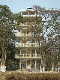
- Rasikbil: It is situated about 42 km from Cooch Behar Town. A recognized bird sanctuary. It has a deer park and a recently built aquarium where fishes, turtles, seven nos. of leopards, Peafowl are kept. You may spot Chinese Fishing Nets on the way to Rasikbil. Rasikbeel is a complex of wet land, the name of important water bodies are Bochamari beel, Rasik beel, Batikata Beel & raichangmari beel. In Bengali beel means large water body. The main migratory bird spp found in this wet land are Lesser Whistling Teal, Common Teal, Cotton Teal, Dapchick, Bronze winged Jacana, Pheasant Tailed Janacana, Shoveler, Barheaded goose, White Eyed Poacherd etc. Except this a lot of other aquatic bird like small & large Cormorant, four spp. of Kingfisher, open bill stork etc. are found. The area of water doby complex is 178 hec. The whole area comes under protected forest & managed by Coochbehar Forest Division. In recent past (Jan, 09) a beautiful watch tower of 70 feet height was constructed by Coochbehar Forest Division. There is a min zoo at Rasikbill, the zoo is recognised by Central Zoo Authority, Govt. of India. There are Tortoise, Gharial, Leopard, Spotted deer, Peafowl and other birds in the zoo. In 2009, Coochbehar Division in collaboration with Zoological Survey of India conducted bird census in the wetland complex, 66 species of birds were recorded.
- Rasomati Ecotourism complex- This ecotourism complex is recently developed by Coochbehar Forest Division. The main attraction is the Rasomati Jheel (Water body) which herbours lots of residential & migratory birds. There is a picnic spot with paddle boating facility for tourist. A six km. long Jungle safari is also major tourist attraction. For observation a tower of height 56 feet has been constructed. The spot is located in the Patlakhawa forest which was a game reserve of the king of Coochbehar.
- Kholta Ecotourism Spot- The spot is on Coochbehar Aliporeduar Road, 20 km away from Coochbehar, Recently (Feb-09) Developed by Coochbehar Forest Division, The children park, Deer park (Sambar & Spotted Deer)& Toy train is the major tourist attraction. The spot is surrounded by Araikumari riverlet, there is old teak plantation created by the king of Coochbehar.
Apart from these other tourist spots are:
- Eco Heritage Park
- Nipendra Narayan Park
- Brahmo Mandir
- Ranir Bagan
- Baradebi Bari
- Siddheswari Kali Bari
- Dangar Ayee Temple
- Siddhanath Siva temple, Dhaluabari
- Madan Mohan temple, Mathabhanga
Demographics
According to the 2011 census2011 census of India
The 15th Indian National census was conducted in two phases, houselisting and population enumeration. Houselisting phase began on April 1, 2010 and involved collection of information about all buildings...
Cooch Behar district has a population
Demographics of India
The demographics of India are inclusive of the second most populous country in the world, with over 1.21 billion people , more than a sixth of the world's population. Already containing 17.5% of the world's population, India is projected to be the world's most populous country by 2025, surpassing...
of 2,822,780, roughly equal to the nation of Jamaica
Jamaica
Jamaica is an island nation of the Greater Antilles, in length, up to in width and 10,990 square kilometres in area. It is situated in the Caribbean Sea, about south of Cuba, and west of Hispaniola, the island harbouring the nation-states Haiti and the Dominican Republic...
or the US state of Kansas
Kansas
Kansas is a US state located in the Midwestern United States. It is named after the Kansas River which flows through it, which in turn was named after the Kansa Native American tribe, which inhabited the area. The tribe's name is often said to mean "people of the wind" or "people of the south...
. This gives it a ranking of 136th in India (out of a total of 640
Districts of India
A district is an administrative division of an Indian state or territory. Districts are further subdivided, in some cases into Sub-Divisions, and otherwise directly into tehsils or talukas.District officials include:...
). The district has a population density of 833 PD/sqkm . Its population growth rate
Family planning in India
Family planning in India is based on efforts largely sponsored by the Indian government. In the 1965-2009 period, contraceptive usage has more than tripled and the fertility rate has more than halved , but the national fertility rate is still high enough to cause long-term population growth...
over the decade 2001-2011 was 13.86 %. Koch Bihar has a sex ratio
Sex ratio
Sex ratio is the ratio of males to females in a population. The primary sex ratio is the ratio at the time of conception, secondary sex ratio is the ratio at time of birth, and tertiary sex ratio is the ratio of mature organisms....
of 942 females
Women in India
The status of women in India has been subject to many great changes over the past few millennia. From equal status with men in ancient times through the low points of the medieval period, to the promotion of equal rights by many reformers, the history of women in India has been eventful...
for every 1000 males, and a literacy rate
Literacy in India
Literacy in India is key for socio-economic progress, and the Indian literacy rate grew to 74.04% in 2011 from 12% at the end of British rule in 1947. Although this was a greater than sixfold improvement, the level is well below the world average literacy rate of 84%, and India currently has the...
of 75.49 %.
Flora and fauna
The flora here includes among others palms, bamboos, creepers, ferns, orchids, aquatic plants, fungi, timber, grass, vegetable and fruit trees.In absence of large forest area in the district, except at Patlakhawa, not many species of animal are found though there are many wildlife sanctuaries, national parks and animal reserves in the neighboring Jalpaiguri
Jalpaiguri
Jalpaiguri is a city in the state of West Bengal, India. It is the headquarters of Jalpaiguri district, and the divisional headquarters of the North Bengal region.-History:...
district and Alipurduar
Alipurduar
Alipurduar is a sub-divisional municipal city of Jalpaiguri district, and is located at the eastern end of the district. Situated on the east bank of Kaljani River on the foothills of the Himalayas, the town is a gateway to Bhutan and North Eastern states of India...
subdivision of Jalpaiguri which are not very far from the district.
In 1976 Cooch Behar district became home to the Jaldapara Wildlife Sanctuary, which has an area of 217 square kilometre. It shares the park with Jalpaiguri district
Jalpaiguri District
Jalpaiguri district is the largest district of North Bengal, covering an area 6,245 km2. It is situated between 26° 16' and 27° 0' North latitudes and 88° 4' and 89° 53' East longitudes...
.
Education
Educational FacilitiesPrimary Schools - 1805
High Schools - 120
Higher Secondary Schools - 61
High Madrasa - 5
Senior Madrasa - 2
Junior High School - 60
Junior High Madrasa - 16
Kendriya vidyalaya - 1
Engineering / Technical Schools - 2
Professional & Technical Schools - 16
General College - 9
Blind School - 1
Libraries - 110
Cooch Behar district has an Agricultural University named Uttar Banga Krishi Viswavidyalaya at Pundibari about 15 km from Cooch Behar Town. Apart from those Government schools there are a few privately aided schools mostly ICSE, ISC and CBSE boards.