
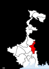
Nadia District
Encyclopedia
Nadia district is a district
of the state of West Bengal
, in the north east of India
. It borders with Bangladesh
to the east, North 24 Parganas
and Hooghly
districts to the south, Bardhaman district
to the west, and Murshidabad district
to the north.
was the capital of Bengal under Ballal Sen and later Lakshman Sen
, the famous rulers of the Sena Empire, who ruled from 1159 to 1206. In 1202, Nabadwip was captured by Bakhtiyar Khilji. This victory paved the way for Muslim rule in Bengal. Nabadwip and Nadia were great centres of learning and intellectual prowess. For five centuries, it was referred to as “Oxford
of Bengal”. Chaitanyadeb (1486–1533) was born in Nabadwip.
It is the only place where the first school of logic(tarkashastra) in India was setup on the Navya Nyaya system, which produced great logicians in 15th century.The Holy Birth Place of Lord Caitanya Mahaprabhu is known as "Gour Gangar Desh" as well as " Oxford of Bengal". We are proud for Srichaitanyadeb, Krishnanda Agambagish, Basudeb Sarbobhouma etc. The religious atmosphere of Nabadwip is a combination of Baishnaba, Shakta, Buddha, Saiba due to the aforesaid leaders, Pal Monarchy, Sen Monarchy etc. The main festival of Nabadwip is "RASH UTSAV". It is also known as "Pat Purnima" or "Rash Kali Puja" or "Shakta Rash". The varieties of Baishnaba, Shakta, Saiba Pratima (Idols) attracts every one. The Rash Utsav is like national festival of the inhabitants of Nabadwip.
Once the capital of Raja Bikramaditya and Maharaja Pratapaditya was at Dhumghat. Later it was transferred to Ishwaripur (Originated from the name Jeshoreshwaripur). Maharaja Pratapaditya declared independence of South Bengal (Jessore, Khulna in north, Sundarbans, Bay of Bengal in South, Barisal in east and River Ganga in west) against the Mughal Empire of India.
Jashoreshwari Kali Temple (built by Pratapaditya), Chanda Bhairab Mandir at Ishwaripur (a triangular temple, built during the Sena period), Five domed Tenga Mosque at Banshipur (Mughal period), two big and four small domed Hammankhana (constructed by Pratapaditya) at Bangshipur, Govinda Dev Temple at Gopalpur (built by Basanta Roy, uncle of Maharaja Pratapaditya in 1593), Jahajghata Port (Khanpur). Pratapaditya king of Jessore and one of the bara-bhuiyans of Bengal. Pratapaditya fought against the Mughal imperial army during its inroad into Bengal in the early 17th century. His father Shrihari (Shridhar), a Kayastha, was an influential officer in the service of daud khan karrani. On the fall of Daud he fled away with the government treasure in his custody. He then set up a kingdom for himself in the marshy land to the extreme south of Khulna district (1574) and took the title of Maharaja. Pratapaditya succeeded to the kingship in 1574. The baharistan and the travel diary of Abdul Latif and the contemporary European writers, all testify to the personal ability of Pratapaditya, his political pre-eminence, material resources and martial strength, particularly in war-boats. His territories covered the greater part of what is now included in the greater Jessore, Khulna and Barisal districts. He established his capital at Dhumghat, a strategic position at the confluence of the Jamuna and Ichhamati.
Among the Bengal zamindars Pratapaditya was the first to send his envoy to Islam Khan Chisti with a large gift to win the favour of the Mughals, and then tendered personal submission to the Subahdar (1609). He promised military assistance and personal service in the Mughal campaign against musa khan, a pledge that he did not keep. To punish Pratapaditya for his disloyalty as a vassal and to subjugate his territory, a large expedition was launched under the command of Ghiyas Khan, which soon reached a place named Salka, near the confluence of the Jamuna and Ichhamati (1611). Pratapaditya equipped a strong army and a fleet and placed them under expert officers including Feringis, Afghans and Pathans. His eldest son Udayaditya made a big fort at Salka with natural barriers on three sides rendering it almost impregnable. In battle the Jessore fleet gained an initial advantage. But the imperial army cut off the Jessore fleet, made a breach in its ranks and broke its unity and discipline. In the melee that followed, the admiral Khwaja Kamal was killed. Udayaditya lost heart and hastily fled to his father, narrowly escaping capture. Jamal Khan evacuated the fort and followed Udayaditya.
Pratapaditya prepared himself to fight a second time from a new base near the confluence of Kagarghat canal and the Jamuna. He made a big fort at a strategic point and gathered all his available forces there. The imperialists began the battle by an attack on the Jessore fleet (Jan 1612) and compelled it to seek shelter beneath the fort. But their further advance was checked by the heavy cannonade of the Jessore artillery. A sudden attack of the imperialists completely defeated the Jessore fleet and they fell upon the fort with the elephants in front, thereby compelling Pratapaditya to evacuate the fort and retreat.
The second defeat sealed the fate of Pratapaditya. At Kagarghat he tendered submission to Ghiyas Khan, who personally escorted Pratapaditya to Islam Khan at Dhaka. The Jessore king was put in chains and his kingdom was annexed. Pratapaditya was kept confined at Dhaka. No authentic information is available regarding his last days. Probably he died at Benares on his way to Delhi, as a prisoner.
was the capital of Bengal under Ballal Sen and later Lakshman Sen
, the famous rulers of the Sena Empire, who ruled from 1159 to 1206.
Krishnanagar is the most important town of this district, as this is district headquarters of Nadia. Krishnanagar is on the bank of river Jalangi. Krishnanagar is named after Raja Krishna Chandra Rai (1728–1782). The Rajbari (palace) built here during the reign of Raja Krishna Chandra Rai is a prominent place of tourist attraction though the remnants of the past glory have been eroded and only a dilapidated structure of the exquisite places with carving on its inner walls exists today. This place is shared by people from Hindu, Muslim & Christian religion. Apart from Hindu temples there are also Christian & Muslim shrines. The Christian Missionaries attached much importance to Krishnanagar. The Protestant Church was built here during 1840s. The Roman Catholic Cathedral was built in 1898. This is town is situated almost 100 km away from Kolkata and older than Kolkata. Famous for clay modelling, potteries, sweets. The origin of famous clay models of Krishnanagar is Ghurni. The clay model artists of Ghurni have won international repute and fame for their excellence in clay modelling. Krishnanagar was the birth place of the noted Poet, Composer and Playwright Shri. Dwijendra Lal Roy (1863–1913) whose contribution to Bengali Literature needs no mention. The town is also known for famous poets/ authors like Bharatchandra, Dr. Sudhir Chakraborty, Dr. Khsudiram Das and actors like Saumitra Chattopadhyay. Shri Somesh Kumar Bhattacharya, IAS is the present executive head called District Magistrate and Collector of Nadia, located at Krishnanagar. Office of the local body for rural areas headed by Mr. Meghlal Sheikh Sabhadhipati is also located at this town.
Kalyani
is another important town of this district. It was identified (and named) by Dr. B. C. Roy to act as an alternative to the city of Kolkata
, from which it is about 50 km away.
Ranaghat
is one of the most important of the towns is Ranaghat
, situated 74 kilometers north of Kolkata
Tehatta
is another important subdivisional town. It is the newest subdivision in the district of Nadia.
Dhubulia
has biggest TB hospital in Asia & Also has a Airport, which used to be in use before 1947 in British Period.
municipality and seven community development blocks: Kaliganj, Nakashipara, Chapra, Krishnanagar–I, Krishnanagar–II, Nabadwip
and Krishnaganj. Kalyani subdivision consists of Chakdaha
municipality, Gayespur
municipality, Kalyani
municipality and two community development blocks: Chakdaha and Haringhata. Ranaghat subdivision consists of Shantipur
municipality, Ranaghat
municipality, Birnagar
municipality and four community development blocks: Hanskhali, Shantipur, Ranaghat–I and Ranaghat–II. Tehatta subdivision consists of four community development blocks: Karimpur–I, Karimpur–II, Tehatta–I and Tehatta–II. Krishnanagar is the district headquarters. There are 19 police stations, 17 development blocks, 8 municipalities, 187 gram panchayat
s and 2639 villages in this district.
Other than municipality area, each subdivision contains community development blocks which in turn are divided into rural areas and census towns. In total there are 29 urban units: 8 municipalities and 15 census town
s and two notified area
s. Ranaghat
, Aistala
, Satigachha
, Nasra
and Cooper's Camp
together forms Ranaghat urban agglomeration. Nabadwip
, Char Maijdia
and Char Brahmanagar
forms Nabadwip UA. Chakdaha
, Gopalpur
and Parbbatipur
forms Chakdaha UA. Krishnanagar and Baruihuda
together forms Krishnanagar UA. Birnagar
, Phulia
and Taherpur
together forms Birnagar UA.
Fulia is located about 26 km from Krishnanagar, the headquarters of Nadia District, in West Bengal. The place has a prominent place in the history of Bengali literature. It is famous as the birth place of Krittibas, who first translated the epic Ramayana from Sanskrit to Bengali in verses.
The residence of Krittibas is now converted in to Krittibas Memorial Community Hall Cum Museum Library. Adjacent to this is a Gofa, the place of worship of Thakur Haridas. The old banyan tree situated nearby; it is said that the poet had translated the Ramayana into Bengali sitting under the tree.
Ganges River flows close to the town. Fulia is also famous for producing Tangail Saree.
National Highway 34 passes through the town. By train, Fulia is about 92 km from Kolkata.
The town of Plassey has a memorial of The Battle of Plassey (Bengali: পলাশীর যুদ্ধ, Pôlashir Juddho), which took place on 23 June 1757, on the riverbanks of the Bhagirathi River, about 150 km north of Calcutta, near Murshidabad, then the capital of the Nawab of Bengal. The battle was a decisive victory for the British East India Company over Siraj Ud Daulah, the last independent Nawab of Bengal and his French allies. This established the Company's rule in India which expanded over much of South Asia for the next 190 years.
Krishnaganj, Hanskhali and Ranaghat East constituencies are reserved for Scheduled Castes (SC) candidates. Along with six assembly constituencies from Murshidabad district
, Karimpur assembly constituency forms the Murshidabad (Lok Sabha constituency)
. Palashipara, Nakashipara, Kaliganj, Chapra, Krishnaganj, Krishnanagar East and Krishnanagar West constituencies form the Krishnagar (Lok Sabha constituency)
. Nabadwip, Shantipur, Hanskhali, Ranaghat East, Ranaghat West, Chakdaha and Haringhata assembly constituencies form the Nabadwip (Lok Sabha constituency)
, which is reserved for Scheduled Castes (SC) candidates.
Krishnaganj, Ranaghat North East, Ranaghat South, Kalyani and Haringhata constituencies will be reserved for Scheduled Castes (SC) candidates. Along with six assembly constituencies from Murshidabad district
, Karimpur assembly constituency will form the Murshidabad (Lok Sabha constituency)
. Tehatta, Palashipara, Kaliganj, Nakashipara, Chapra, Krishnanagar North and Nabadwip constituencies form the Krishnanagar (Lok Sabha constituency). Krishnanagar South, Shantipur, Ranaghat North West, Krishnaganj, Ranaghat North East, Ranaghat South and Chakdaha assembly constituencies will form the Ranaghat (Lok Sabha constituency)
, which will be reserved for Scheduled Castes (SC) candidates. Kalyani and Haringhata, along with five assembly segments from North 24 Parganas district
, will form the Bangaon (Lok Sabha constituency)
, which will be reserved for Scheduled Castes (SC) candidates.
, 105 km from Howrah and 112 km from Sealdah
on the Bandel-Katwa
-Azimganj (B.A.K Loop Line) section of Eastern Railway
. It has three Railway Stations as Nabadwip Dham (NDAE), Bishnupriya (VSPR) of Howrah Division and Nabadwip Ghat (NDF) of Sealdah Division. It has very good railway communication with North Bengal, Assam, Bihar, Orissa and Kolkata. Important express trains which has stoppage at Nabadwip Dham are
15643 UP/15644 DN Puri-Kamakhya Express
15959 UP/15960 DN Howrah-Tinsukia-Dibrugarh Kamrup Express
13141 UP/13142 DN Sealdah-New Alipurduar/Haldibari Teesta Torsha Express
13164 UP/13165 DN Sealdah-Barauni-Katihar-Saharsha Hatey Bazare Express
13145 UP/13146 DN Sealdah-Radhikapur Radhikapur Express
13011 UP/13012 DN Howrah Maldah Intercity Express
13421 UP/13422 DN Nabadwip Dham- New Frakka Express
15721 UP/15722 DN New Jalpaiguri-Digha Paharia Express
12517 UP/12518 DN Kolkata Guwahati Garib Rath Express.
Krishnanagar City Junction is 100 km from Sealdah on the Sealdah-Lalgola Section of Eastern Railway
. It has very good railway communication with Murshidabad, Nadia, North 24 Parganas and Kolkata. Important express trains which has stoppage at Krishnanagar City Junction are
Bhagirathi Express
Hazar Duari Express.
Ranaghat Junction is 74 km from Sealdah on the Sealdah-Lalgola Section of Eastern Railway
. It has very good railway communication with Murshidabad, Nadia, North 24 Parganas and Kolkata. Important express trains which has stoppage at Ranaghat Junction are
Bhagirathi Express
Hazar Duari Express.
has a population
of 5,168,488 , roughly equal to the United Arab Emirates
or the US state of Colorado
. This gives it a ranking of 18th in India (out of a total of 640
). The district has a population density of 1316 PD/sqkm . Its population growth rate
over the decade 2001-2011 was 12.24 %. Nadia has a sex ratio
of 947 females
for every 1000 males, and a literacy rate
of 75.58 %.
, Sri Advaita Acharya
, Dwijendralal Roy
, Sir Azizul Haque
, Ramtanu Lahiri
, Kabi Krittibas Ojha
, Kabi Mohammed Mozammel Haque
, Kabi Jatindranath Sengupta, kabi Modon Mohan Tarkalankar.
Districts of India
A district is an administrative division of an Indian state or territory. Districts are further subdivided, in some cases into Sub-Divisions, and otherwise directly into tehsils or talukas.District officials include:...
of the state of West Bengal
West Bengal
West Bengal is a state in the eastern region of India and is the nation's fourth-most populous. It is also the seventh-most populous sub-national entity in the world, with over 91 million inhabitants. A major agricultural producer, West Bengal is the sixth-largest contributor to India's GDP...
, in the north east of India
India
India , officially the Republic of India , is a country in South Asia. It is the seventh-largest country by geographical area, the second-most populous country with over 1.2 billion people, and the most populous democracy in the world...
. It borders with Bangladesh
Bangladesh
Bangladesh , officially the People's Republic of Bangladesh is a sovereign state located in South Asia. It is bordered by India on all sides except for a small border with Burma to the far southeast and by the Bay of Bengal to the south...
to the east, North 24 Parganas
North 24 Parganas district
North 24 Parganas district is a district in southern West Bengal, of eastern India. North 24 Parganas extends in the [tropical zone] from latitude 22º11'6" north to 23º15'2" north and from longitude 88º20' east to 89º5' east...
and Hooghly
Hooghly District
Hooghly district is one of the districts of the state of West Bengal in India. It can alternatively be spelt Hoogli or Hugli. The district is named after the Hooghly River.The headquarters of the district are at Chinsura...
districts to the south, Bardhaman district
Bardhaman District
'Bardhaman district is a district in West Bengal. The headquarter of the district is Bardhaman, though it houses other important industrial towns like Durgapur and Asansol...
to the west, and Murshidabad district
Murshidabad district
Murshidabad district is a district of West Bengal in eastern India. Situated on the left bank of the river Ganges, the district is very fertile. Covering an area of 5,341 km² and having a population 5.863m it is a densely populated district and the ninth most populous in India...
to the north.
History
NabadwipNabadwip
Nabadwip is a city and a municipality in Nadia district in the Indian state of West Bengal. Its name means "9 islands" in the Bengali language. The islands are named Antardwip , Simantadwip, Rudradwip, Madhyadwip, Godrumdwip, Ritudwip, Jahnudwip, Modadrumdwip, and Koladwip...
was the capital of Bengal under Ballal Sen and later Lakshman Sen
Lakshman Sen
Lakshman Sen was the fourth king of the Sen dynasty of Bengal, who ruled for about 28 years. Lakshman Sen succeeded his father Ballal Sen...
, the famous rulers of the Sena Empire, who ruled from 1159 to 1206. In 1202, Nabadwip was captured by Bakhtiyar Khilji. This victory paved the way for Muslim rule in Bengal. Nabadwip and Nadia were great centres of learning and intellectual prowess. For five centuries, it was referred to as “Oxford
Oxford
The city of Oxford is the county town of Oxfordshire, England. The city, made prominent by its medieval university, has a population of just under 165,000, with 153,900 living within the district boundary. It lies about 50 miles north-west of London. The rivers Cherwell and Thames run through...
of Bengal”. Chaitanyadeb (1486–1533) was born in Nabadwip.
It is the only place where the first school of logic(tarkashastra) in India was setup on the Navya Nyaya system, which produced great logicians in 15th century.The Holy Birth Place of Lord Caitanya Mahaprabhu is known as "Gour Gangar Desh" as well as " Oxford of Bengal". We are proud for Srichaitanyadeb, Krishnanda Agambagish, Basudeb Sarbobhouma etc. The religious atmosphere of Nabadwip is a combination of Baishnaba, Shakta, Buddha, Saiba due to the aforesaid leaders, Pal Monarchy, Sen Monarchy etc. The main festival of Nabadwip is "RASH UTSAV". It is also known as "Pat Purnima" or "Rash Kali Puja" or "Shakta Rash". The varieties of Baishnaba, Shakta, Saiba Pratima (Idols) attracts every one. The Rash Utsav is like national festival of the inhabitants of Nabadwip.
Once the capital of Raja Bikramaditya and Maharaja Pratapaditya was at Dhumghat. Later it was transferred to Ishwaripur (Originated from the name Jeshoreshwaripur). Maharaja Pratapaditya declared independence of South Bengal (Jessore, Khulna in north, Sundarbans, Bay of Bengal in South, Barisal in east and River Ganga in west) against the Mughal Empire of India.
Jashoreshwari Kali Temple (built by Pratapaditya), Chanda Bhairab Mandir at Ishwaripur (a triangular temple, built during the Sena period), Five domed Tenga Mosque at Banshipur (Mughal period), two big and four small domed Hammankhana (constructed by Pratapaditya) at Bangshipur, Govinda Dev Temple at Gopalpur (built by Basanta Roy, uncle of Maharaja Pratapaditya in 1593), Jahajghata Port (Khanpur). Pratapaditya king of Jessore and one of the bara-bhuiyans of Bengal. Pratapaditya fought against the Mughal imperial army during its inroad into Bengal in the early 17th century. His father Shrihari (Shridhar), a Kayastha, was an influential officer in the service of daud khan karrani. On the fall of Daud he fled away with the government treasure in his custody. He then set up a kingdom for himself in the marshy land to the extreme south of Khulna district (1574) and took the title of Maharaja. Pratapaditya succeeded to the kingship in 1574. The baharistan and the travel diary of Abdul Latif and the contemporary European writers, all testify to the personal ability of Pratapaditya, his political pre-eminence, material resources and martial strength, particularly in war-boats. His territories covered the greater part of what is now included in the greater Jessore, Khulna and Barisal districts. He established his capital at Dhumghat, a strategic position at the confluence of the Jamuna and Ichhamati.
Among the Bengal zamindars Pratapaditya was the first to send his envoy to Islam Khan Chisti with a large gift to win the favour of the Mughals, and then tendered personal submission to the Subahdar (1609). He promised military assistance and personal service in the Mughal campaign against musa khan, a pledge that he did not keep. To punish Pratapaditya for his disloyalty as a vassal and to subjugate his territory, a large expedition was launched under the command of Ghiyas Khan, which soon reached a place named Salka, near the confluence of the Jamuna and Ichhamati (1611). Pratapaditya equipped a strong army and a fleet and placed them under expert officers including Feringis, Afghans and Pathans. His eldest son Udayaditya made a big fort at Salka with natural barriers on three sides rendering it almost impregnable. In battle the Jessore fleet gained an initial advantage. But the imperial army cut off the Jessore fleet, made a breach in its ranks and broke its unity and discipline. In the melee that followed, the admiral Khwaja Kamal was killed. Udayaditya lost heart and hastily fled to his father, narrowly escaping capture. Jamal Khan evacuated the fort and followed Udayaditya.
Pratapaditya prepared himself to fight a second time from a new base near the confluence of Kagarghat canal and the Jamuna. He made a big fort at a strategic point and gathered all his available forces there. The imperialists began the battle by an attack on the Jessore fleet (Jan 1612) and compelled it to seek shelter beneath the fort. But their further advance was checked by the heavy cannonade of the Jessore artillery. A sudden attack of the imperialists completely defeated the Jessore fleet and they fell upon the fort with the elephants in front, thereby compelling Pratapaditya to evacuate the fort and retreat.
The second defeat sealed the fate of Pratapaditya. At Kagarghat he tendered submission to Ghiyas Khan, who personally escorted Pratapaditya to Islam Khan at Dhaka. The Jessore king was put in chains and his kingdom was annexed. Pratapaditya was kept confined at Dhaka. No authentic information is available regarding his last days. Probably he died at Benares on his way to Delhi, as a prisoner.
Important towns
NabadwipNabadwip
Nabadwip is a city and a municipality in Nadia district in the Indian state of West Bengal. Its name means "9 islands" in the Bengali language. The islands are named Antardwip , Simantadwip, Rudradwip, Madhyadwip, Godrumdwip, Ritudwip, Jahnudwip, Modadrumdwip, and Koladwip...
was the capital of Bengal under Ballal Sen and later Lakshman Sen
Lakshman Sen
Lakshman Sen was the fourth king of the Sen dynasty of Bengal, who ruled for about 28 years. Lakshman Sen succeeded his father Ballal Sen...
, the famous rulers of the Sena Empire, who ruled from 1159 to 1206.
Krishnanagar is the most important town of this district, as this is district headquarters of Nadia. Krishnanagar is on the bank of river Jalangi. Krishnanagar is named after Raja Krishna Chandra Rai (1728–1782). The Rajbari (palace) built here during the reign of Raja Krishna Chandra Rai is a prominent place of tourist attraction though the remnants of the past glory have been eroded and only a dilapidated structure of the exquisite places with carving on its inner walls exists today. This place is shared by people from Hindu, Muslim & Christian religion. Apart from Hindu temples there are also Christian & Muslim shrines. The Christian Missionaries attached much importance to Krishnanagar. The Protestant Church was built here during 1840s. The Roman Catholic Cathedral was built in 1898. This is town is situated almost 100 km away from Kolkata and older than Kolkata. Famous for clay modelling, potteries, sweets. The origin of famous clay models of Krishnanagar is Ghurni. The clay model artists of Ghurni have won international repute and fame for their excellence in clay modelling. Krishnanagar was the birth place of the noted Poet, Composer and Playwright Shri. Dwijendra Lal Roy (1863–1913) whose contribution to Bengali Literature needs no mention. The town is also known for famous poets/ authors like Bharatchandra, Dr. Sudhir Chakraborty, Dr. Khsudiram Das and actors like Saumitra Chattopadhyay. Shri Somesh Kumar Bhattacharya, IAS is the present executive head called District Magistrate and Collector of Nadia, located at Krishnanagar. Office of the local body for rural areas headed by Mr. Meghlal Sheikh Sabhadhipati is also located at this town.
Kalyani
Kalyani, West Bengal
Kalyani is a city and a municipality in Nadia district in the Indian state of West Bengal. It is a part of the area covered by Kolkata Metropolitan Development Authority....
is another important town of this district. It was identified (and named) by Dr. B. C. Roy to act as an alternative to the city of Kolkata
Kolkata
Kolkata , formerly known as Calcutta, is the capital of the Indian state of West Bengal. Located on the east bank of the Hooghly River, it was the commercial capital of East India...
, from which it is about 50 km away.
Ranaghat
Ranaghat
Ranaghat is a city in the district of Nadia, West Bengal, India. It is situated 74 kilometres north of Calcutta. It is known for its handloom industry, various types of flowers and sweet dishes. The town has spread up along its borders in all corners recently. People from the nearby places do come...
is one of the most important of the towns is Ranaghat
Ranaghat
Ranaghat is a city in the district of Nadia, West Bengal, India. It is situated 74 kilometres north of Calcutta. It is known for its handloom industry, various types of flowers and sweet dishes. The town has spread up along its borders in all corners recently. People from the nearby places do come...
, situated 74 kilometers north of Kolkata
Kolkata
Kolkata , formerly known as Calcutta, is the capital of the Indian state of West Bengal. Located on the east bank of the Hooghly River, it was the commercial capital of East India...
Tehatta
Tehatta
Tehatta is headquarters of Tehatta subdivision in Nadia district in the Indian state of West Bengal. The place has been a recent addition in the list of sub-divisions in the district of Nadia...
is another important subdivisional town. It is the newest subdivision in the district of Nadia.
Dhubulia
Dhubulia
Dhubulia is a village in Nadia district of West Bengal, India. It has the biggest tuberculosis Hospital in Asia. Belpukur is the oldest neighborhood in the village.- History :...
has biggest TB hospital in Asia & Also has a Airport, which used to be in use before 1947 in British Period.
Important Villages
It has been reported that the following list of Villages are in Nadia District- Bahirgachhi HaltBahirgachhi NewBahirgachhi Halt is a village and small railway station in Nadia district of West Bengal, India. This is known for railway stations which connects Gede , Ranaghat and Sealdah in Kolkata Suburban Railway system in West Bengal Railways....
- Cheuria
- Devagram
- DhubuliaDhubuliaDhubulia is a village in Nadia district of West Bengal, India. It has the biggest tuberculosis Hospital in Asia. Belpukur is the oldest neighborhood in the village.- History :...
- Eralbahadurpur
- GhoshparaKalyani, West BengalKalyani is a city and a municipality in Nadia district in the Indian state of West Bengal. It is a part of the area covered by Kolkata Metropolitan Development Authority....
(presently, a neighbourhood of Kalyani city) - KutabpurKutabpurKutabpur , a village in Nadia district , situated to the south of the Western bank of the river Bhairab, where the indigo godown was once built. Year back, the English merchants were engaged in the trade of indigo on the banks of Bhairab...
- Nabadwip GhatNabadwip GhatNabadwip Ghat is a village in Nadia district in the Indian state of West Bengal. It is located from Krishnagar, Nadia....
- Suvarnapur
Administrative subdivisions
The district comprises four subdivisions: Krishnanagar Sadar, Kalyani, Ranaghat and Tehatta. Krishnanagar Sadar subdivision consists of Krishnanagar municipality, NabadwipNabadwip
Nabadwip is a city and a municipality in Nadia district in the Indian state of West Bengal. Its name means "9 islands" in the Bengali language. The islands are named Antardwip , Simantadwip, Rudradwip, Madhyadwip, Godrumdwip, Ritudwip, Jahnudwip, Modadrumdwip, and Koladwip...
municipality and seven community development blocks: Kaliganj, Nakashipara, Chapra, Krishnanagar–I, Krishnanagar–II, Nabadwip
Nabadwip
Nabadwip is a city and a municipality in Nadia district in the Indian state of West Bengal. Its name means "9 islands" in the Bengali language. The islands are named Antardwip , Simantadwip, Rudradwip, Madhyadwip, Godrumdwip, Ritudwip, Jahnudwip, Modadrumdwip, and Koladwip...
and Krishnaganj. Kalyani subdivision consists of Chakdaha
Chakdaha
Chakdaha is a city and a municipality in Kalyani subdivision of Nadia district in the state of West Bengal, India.-Geography:Chakdaha is located at . It has an average elevation of 11 metres...
municipality, Gayespur
Gayespur
Gayespur is a town and a municipality under Kalyani police station of Kalyani subdivision in Nadia district in the Indian state of West Bengal.-Geography:...
municipality, Kalyani
Kalyani, West Bengal
Kalyani is a city and a municipality in Nadia district in the Indian state of West Bengal. It is a part of the area covered by Kolkata Metropolitan Development Authority....
municipality and two community development blocks: Chakdaha and Haringhata. Ranaghat subdivision consists of Shantipur
Shantipur
Shantipur is a city and a municipality in Nadia district in the Indian state of West Bengal. This small town has been declared a city recently. The fort area of this city, also known as Daak-Gharh is thought to have been built by Raja Krishnachandra of Nodia.-Geography:Shantipur is located at...
municipality, Ranaghat
Ranaghat
Ranaghat is a city in the district of Nadia, West Bengal, India. It is situated 74 kilometres north of Calcutta. It is known for its handloom industry, various types of flowers and sweet dishes. The town has spread up along its borders in all corners recently. People from the nearby places do come...
municipality, Birnagar
Birnagar
Birnagar is a city and a municipality under Taherpur police station of Ranaghat subdivision in Nadia district in the state of West Bengal, India.-History:...
municipality and four community development blocks: Hanskhali, Shantipur, Ranaghat–I and Ranaghat–II. Tehatta subdivision consists of four community development blocks: Karimpur–I, Karimpur–II, Tehatta–I and Tehatta–II. Krishnanagar is the district headquarters. There are 19 police stations, 17 development blocks, 8 municipalities, 187 gram panchayat
Gram panchayat
Gram panchayats are local self-governments at the village or small town level in India. As of 2002 there were about 265,000 gram panchayats in India. The gram panchayat is the foundation of the Panchayat System. A gram panchayat can be set up in villages with minimum population of 300...
s and 2639 villages in this district.
Other than municipality area, each subdivision contains community development blocks which in turn are divided into rural areas and census towns. In total there are 29 urban units: 8 municipalities and 15 census town
Census town
In India, a census town is one which has:# A minimum population of 5,000# At least 75% of male working population engaged in non-agricultural pursuits# A density of population of at least 400 persons per km2.In Ireland, a census town is;...
s and two notified area
Notified area
In urban planning, a notified area is any land area earmarked by legal provision for future development. The term is used in the Hindi belt region of North India....
s. Ranaghat
Ranaghat
Ranaghat is a city in the district of Nadia, West Bengal, India. It is situated 74 kilometres north of Calcutta. It is known for its handloom industry, various types of flowers and sweet dishes. The town has spread up along its borders in all corners recently. People from the nearby places do come...
, Aistala
Aistala
Aistala is a census town under Ranaghat police station of Ranaghat subdivision in Nadia district in the Indian state of West Bengal.-Geography:...
, Satigachha
Satigachha
Satigachha is a census town under Ranaghat police station of Ranaghat subdivision in Nadia district in the Indian state of West Bengal.-Geography:...
, Nasra
Nasra
Nasra or Nasr was a Georgian prince of the Bagratid dynasty of Tao-Klarjeti involved and eventually killed in a dynastic war with his relatives....
and Cooper's Camp
Cooper's Camp
Cooper's Camp is a city and a notified area in Nadia district under Ranaghat police station of Ranaghat subdivision in the state of West Bengal, India.-Geography:...
together forms Ranaghat urban agglomeration. Nabadwip
Nabadwip
Nabadwip is a city and a municipality in Nadia district in the Indian state of West Bengal. Its name means "9 islands" in the Bengali language. The islands are named Antardwip , Simantadwip, Rudradwip, Madhyadwip, Godrumdwip, Ritudwip, Jahnudwip, Modadrumdwip, and Koladwip...
, Char Maijdia
Char Maijdia
Char Maijdia is a census town under Nabadwip police station of Krishnanagar subdivision in Nadia district in the state of West Bengal, India.-Geography:...
and Char Brahmanagar
Char Brahmanagar
Char Brahmanagar is a census town under Nabadwip police station of Krishnanagar Sadar subdivision in Nadia district in the state of West Bengal, India.-Geography:...
forms Nabadwip UA. Chakdaha
Chakdaha
Chakdaha is a city and a municipality in Kalyani subdivision of Nadia district in the state of West Bengal, India.-Geography:Chakdaha is located at . It has an average elevation of 11 metres...
, Gopalpur
Gopalpur
Gopalpur is a census town under Ranaghat police station of Ranaghat subdivision in Nadia district in the Indian state of West Bengal.-Geography:...
and Parbbatipur
Parbbatipur
Parbbatipur is a census town under Ranaghat police station of Ranaghat subdivision in Nadia district in the Indian state of West Bengal.-Geography:...
forms Chakdaha UA. Krishnanagar and Baruihuda
Baruihuda
Baruihuda is a census town under Krishnanagar police station of Krishnanagar subdivision in Nadia district in the state of West Bengal, India.-Demographics:...
together forms Krishnanagar UA. Birnagar
Birnagar
Birnagar is a city and a municipality under Taherpur police station of Ranaghat subdivision in Nadia district in the state of West Bengal, India.-History:...
, Phulia
Phulia
Phulia is a census town under Shantipur police station of Ranaghat subdivision in Nadia district in the Indian state of West Bengal....
and Taherpur
Taherpur
Taherpur is a city and a notified area under Taherpur police station at TAHERPUR Nadia district in the Indian state of West Bengal.-Geography:...
together forms Birnagar UA.
Krishnanagar Sadar subdivision
- Krishnanagar: municipality
- NabadwipNabadwipNabadwip is a city and a municipality in Nadia district in the Indian state of West Bengal. Its name means "9 islands" in the Bengali language. The islands are named Antardwip , Simantadwip, Rudradwip, Madhyadwip, Godrumdwip, Ritudwip, Jahnudwip, Modadrumdwip, and Koladwip...
: municipality - Kaliganj (Community development block) consists of rural areas only with 15 gram panchayats.
- Nakashipara (Community development block) consists of rural areas with 15 gram panchayats and two census town: JagadanandapurJagadanandapurJagadanandapur is a census town under Nakashipara police station of Krishnanagar subdivision in Nadia district in the Indian state of West Bengal.-Geography:...
and KshidirpurKshidirpurKshidirpur is a census town under Nakashipara police station of Krishnanagar subdivision in Nadia district in the Indian state of West Bengal.-Geography:Kshidirpur is located at...
. - Chapra, Nadia (Community development block) consists of rural areas with only 13 gram panchayats.
- Krishnanagar I (Community development block)Krishnanagar I (Community development block)Krishnanagar I is an administrative division in Krishnanagar Sadar subdivision of Nadia district in the Indian state of West Bengal. Krishnanagar police station serves this block. Headquarters of this block is at Krishnanagar Road...
consists of rural areas with 12 gram panchayats and one census town: BaruihudaBaruihudaBaruihuda is a census town under Krishnanagar police station of Krishnanagar subdivision in Nadia district in the state of West Bengal, India.-Demographics:...
. - Krishnanagar II (Community development block)Krishnanagar II (Community development block)Krishnanagar II is an administrative division in Krishnanagar Sadar subdivision of Nadia district in the Indian state of West Bengal. Dhubulia Investigation Centre police station serves this block...
consists of rural areas only with 7 gram panchayats. - Nabadwip (Community development block)Nabadwip (Community development block)Nabadwip is an administrative division in Krishnanagar Sadar subdivision of Nadia district in the Indian state of West Bengal. Nabadwip police station serves this block. Headquarters of this block is at Maheshganj...
consists of rural areas with 8 gram panchayats and three census towns: Bablari DewanganjBablari DewanganjBablari Dewanganj is a census town under Nabadwip police station of Krishnanagar subdivision in Nadia district in the state of West Bengal, India.-Geography:...
, Char MaijdiaChar MaijdiaChar Maijdia is a census town under Nabadwip police station of Krishnanagar subdivision in Nadia district in the state of West Bengal, India.-Geography:...
and Char BrahmanagarChar BrahmanagarChar Brahmanagar is a census town under Nabadwip police station of Krishnanagar Sadar subdivision in Nadia district in the state of West Bengal, India.-Geography:...
. - Krishnaganj (Community development block) consists of rural areas only with 7 gram panchayats.
Kalyani subdivision
- ChakdahaChakdahaChakdaha is a city and a municipality in Kalyani subdivision of Nadia district in the state of West Bengal, India.-Geography:Chakdaha is located at . It has an average elevation of 11 metres...
: municipality - KalyaniKalyani, West BengalKalyani is a city and a municipality in Nadia district in the Indian state of West Bengal. It is a part of the area covered by Kolkata Metropolitan Development Authority....
: municipality - GayespurGayespurGayespur is a town and a municipality under Kalyani police station of Kalyani subdivision in Nadia district in the Indian state of West Bengal.-Geography:...
: municipality - Chakdaha (Community development block)Chakdaha (Community development block)Chakdaha is an administrative division in Kalyani subdivision of Nadia district in the Indian state of West Bengal. Chakdaha and Kalyani police stations serve this block. Headquarters of this block is at Chakdaha...
consists of rural areas with 17 gram panchayats and two census towns: DarappurDarappurDarappur is a census town under Chakdaha police station of Kalyani subdivision in Nadia district in the state of West Bengal, India.-Geography:...
and MadanpurMadanpurMadanpur is a census town under Kalyani police station of Kalyani subdivision in Nadia district in the Indian state of West Bengal.-Geography:Madanpur is located at . It has an average elevation of .-Demographics:...
. - Haringhata (Community development block)Haringhata (Community development block)Haringhata is an administrative division in Kalyani subdivision of Nadia district in the Indian state of West Bengal. Haringhata police station serves this block...
consists of rural areas only with 10 gram panchayats.
Ranaghat subdivision
- ShantipurShantipurShantipur is a city and a municipality in Nadia district in the Indian state of West Bengal. This small town has been declared a city recently. The fort area of this city, also known as Daak-Gharh is thought to have been built by Raja Krishnachandra of Nodia.-Geography:Shantipur is located at...
: municipality - RanaghatRanaghatRanaghat is a city in the district of Nadia, West Bengal, India. It is situated 74 kilometres north of Calcutta. It is known for its handloom industry, various types of flowers and sweet dishes. The town has spread up along its borders in all corners recently. People from the nearby places do come...
: municipality - BirnagarBirnagarBirnagar is a city and a municipality under Taherpur police station of Ranaghat subdivision in Nadia district in the state of West Bengal, India.-History:...
: municipality - Hanskhali (Community development block) consists of rural areas only with 13 gram panchayats.
- Santipur (Community development block)Santipur (Community development block)Santipur is an administrative division in Ranaghat subdivision of Nadia district in the Indian state of West Bengal. Shantipur police station serves this block. Headquarters of this block is at Fulia Kolony...
consists of rural areas with 10 gram panchayats and one census town, PhuliaPhuliaPhulia is a census town under Shantipur police station of Ranaghat subdivision in Nadia district in the Indian state of West Bengal....
. - Ranaghat I (Community development block)Ranaghat I (Community development block)Ranaghat I is an administrative division in Ranaghat subdivision of Nadia district in the Indian state of West Bengal. Ranaghat police station serves this block. Headquarters of this block is at Habibpur...
consists of rural areas with 10 gram panchayats and four census towns: AistalaAistalaAistala is a census town under Ranaghat police station of Ranaghat subdivision in Nadia district in the Indian state of West Bengal.-Geography:...
, SatigachhaSatigachhaSatigachha is a census town under Ranaghat police station of Ranaghat subdivision in Nadia district in the Indian state of West Bengal.-Geography:...
, Gopalpur and ParbbatipurParbbatipurParbbatipur is a census town under Ranaghat police station of Ranaghat subdivision in Nadia district in the Indian state of West Bengal.-Geography:...
and one notified area: TaherpurTaherpurTaherpur is a city and a notified area under Taherpur police station at TAHERPUR Nadia district in the Indian state of West Bengal.-Geography:...
. - Ranaghat II (Community development block)Ranaghat II (Community development block)Ranaghat II is an administrative division in Ranaghat subdivision of Nadia district in the Indian state of West Bengal. Ranaghat and Dhantala police stations serve this block. Headquarters of this block is at Nokari...
consists of rural areas with 14 gram panchayats and one census town: NasraNasra, RanaghatNasra is a census town under Ranaghat police station of Ranaghat sub division in Nadia district in the Indian state of West Bengal.-Geography:...
and one notified area: Cooper's CampCooper's CampCooper's Camp is a city and a notified area in Nadia district under Ranaghat police station of Ranaghat subdivision in the state of West Bengal, India.-Geography:...
.
Tehatta subdivision
- Karimpur I (Community development block)Karimpur I (Community development block)Karimpur I is an administrative division in Tehatta subdivision of Nadia district in the Indian state of West Bengal. Karimpur, Hogolberia and Murutia police stations serve this block. Headquarters of this block is at Sikarpur...
consists of rural areas with 8 gram panchayats and one census town: KarimpurKarimpurKarimpur is a census town in Tehatta subdivision of Nadia district in the Indian state of West Bengal.- History :Like any other small village town in Ganges delta, it was a small river port during the time of Mughal...
. - Karimpur II (Community development block)Karimpur II (Community development block)Karimpur II is an administrative division in Tehatta subdivision of Nadia district in the Indian state of West Bengal. Karimpur, Thanapara and Murutia police stations serve this block...
consists of rural areas only with 10 gram panchayats. - Tehatta I (Community development block)Tehatta I (Community development block)Tehatta I is an administrative division in Tehatta subdivision of Nadia district in the Indian state of West Bengal. Tehatta police station serves this block...
consists of rural areas only with 11 gram panchayats. - Tehatta II (Community development block) consists of rural areas only with 7 gram panchayats.
Fulia is located about 26 km from Krishnanagar, the headquarters of Nadia District, in West Bengal. The place has a prominent place in the history of Bengali literature. It is famous as the birth place of Krittibas, who first translated the epic Ramayana from Sanskrit to Bengali in verses.
The residence of Krittibas is now converted in to Krittibas Memorial Community Hall Cum Museum Library. Adjacent to this is a Gofa, the place of worship of Thakur Haridas. The old banyan tree situated nearby; it is said that the poet had translated the Ramayana into Bengali sitting under the tree.
Ganges River flows close to the town. Fulia is also famous for producing Tangail Saree.
National Highway 34 passes through the town. By train, Fulia is about 92 km from Kolkata.
The town of Plassey has a memorial of The Battle of Plassey (Bengali: পলাশীর যুদ্ধ, Pôlashir Juddho), which took place on 23 June 1757, on the riverbanks of the Bhagirathi River, about 150 km north of Calcutta, near Murshidabad, then the capital of the Nawab of Bengal. The battle was a decisive victory for the British East India Company over Siraj Ud Daulah, the last independent Nawab of Bengal and his French allies. This established the Company's rule in India which expanded over much of South Asia for the next 190 years.
Assembly constituencies
The district is divided into 15 assembly constituencies:- KarimpurKarimpur (Vidhan Sabha constituency)Karimpur is an assembly constituency in Nadia district in the Indian state of West Bengal.-Extent:As per orders of the Delimitation Commission, No...
(assembly constituency no. 69), - PalashiparaPalashipara (Vidhan Sabha constituency)Palashipara is an assembly constituency in Nadia district in the Indian state of West Bengal.-Extent:As per orders of the Delimitation Commission, No...
(assembly constituency no. 70), - NakshiparaNakashipara (Vidhan Sabha constituency)Nakashipara is an assembly constituency in Nadia district in the Indian state of West Bengal.-Extent:As per orders of the Delimitation Commission, No...
(assembly constituency no. 71), - KaliganjKaliganj (Vidhan Sabha constituency)Kaliganj is an assembly constituency in Nadia district in the Indian state of West Bengal.-Extent:As per orders of the Delimitation Commission, No. 80 Kaliganj is composed of the following: Bara Chandghar...
(assembly constituency no. 72), - ChapraChapra (Vidhan Sabha constituency)Chapra is an assembly constituency in Nadia district in the Indian state of West Bengal.-Extent:As per orders of the Delimitation Commission, No. 82 Chapra is composed of the following: Chapra community development block.Chapra is part of No...
(assembly constituency no. 73), - Krishnaganj (SC)Krishnaganj (Vidhan Sabha constituency)Krishnaganj is an assembly constituency in Nadia district in the Indian state of West Bengal. The seat is reserved for scheduled castes. Hanskhali ceases to exist from 2011.-Extent:...
(assembly constituency no. 74), - Krishnanagar EastKrishnanagar Uttar (Vidhan Sabha constituency)Krishnanagar Uttar is an assembly constituency in Nadia district in the Indian state of West Bengal.-Extent:As per orders of the Delimitation Commission, No...
(assembly constituency no. 75), - Krishnanagar WestKrishnanagar Dakshin (Vidhan Sabha constituency)Krishnanagar Dakshin is an assembly constituency in Nadia district in the Indian state of West Bengal.-Extent:As per orders of the Delimitation Commission, No...
(assembly constituency no. 76), - NabadwipNabadwip (Vidhan Sabha constituency)Nabadwip is an assembly constituency in Nadia district in the Indian state of West Bengal.-Extent:As per orders of the Delimitation Commission, No...
(assembly constituency no. 77), - Shantipur (assembly constituency no. 78),
- Hanskhali (SC)Hanskhali (Vidhan Sabha constituency)Hanskhali was an assembly constituency in Nadia district in the Indian state of West Bengal. The seat was reserved for scheduled castes. As a consequence of the order of the Delimitation Commission Hanskhali ceases to exist from 2011...
(assembly constituency no. 79), - Ranaghat East (SC)Ranaghat Uttar Paschim (Vidhan Sabha constituency)Ranaghat Uttar Paschim is an assembly constituency in Nadia district in the Indian state of West Bengal.-Extent:As per orders of the Delimitation Commission, No...
(assembly constituency no. 80), - Ranaghat WestRanaghat Dakshin (Vidhan Sabha constituency)Ranaghat Dakshin is an assembly constituency in Nadia district in the Indian state of West Bengal. The seat is reserved for scheduled castes.-Extent:As per orders of the Delimitation Commission, No...
(assembly constituency no. 81), - ChakdahaChakdaha (Vidhan Sabha constituency)Chakdaha is an assembly constituency in Nadia district in the Indian state of West Bengal.-Extent:As per orders of the Delimitation Commission, No...
(assembly constituency no. 82) and - HaringhataHaringhata (Vidhan Sabha constituency)Haringhata is an assembly constituency in Nadia district in the Indian state of West Bengal. The seat is reserved for scheduled castes from 2011. It was an open seat up to 2006.-Extent:...
(assembly constituency no. 83).
Krishnaganj, Hanskhali and Ranaghat East constituencies are reserved for Scheduled Castes (SC) candidates. Along with six assembly constituencies from Murshidabad district
Murshidabad district
Murshidabad district is a district of West Bengal in eastern India. Situated on the left bank of the river Ganges, the district is very fertile. Covering an area of 5,341 km² and having a population 5.863m it is a densely populated district and the ninth most populous in India...
, Karimpur assembly constituency forms the Murshidabad (Lok Sabha constituency)
Murshidabad (Lok Sabha constituency)
Murshidabad is a parliamentary constituency in Murshidabad district, West Bengal, India.-Assembly segments:As per order of the Delimitation Commission in respect of the delimitation of constituencies in the West Bengal, parliamentary constituency no. 11 Murshidabad is composed of the following...
. Palashipara, Nakashipara, Kaliganj, Chapra, Krishnaganj, Krishnanagar East and Krishnanagar West constituencies form the Krishnagar (Lok Sabha constituency)
Krishnagar (Lok Sabha constituency)
Krishnanagar Lok Sabha constituency is one of the 42 Lok Sabha constituencies in West Bengal state in eastern India.-Assembly segments:...
. Nabadwip, Shantipur, Hanskhali, Ranaghat East, Ranaghat West, Chakdaha and Haringhata assembly constituencies form the Nabadwip (Lok Sabha constituency)
Nabadwip (Lok Sabha constituency)
Nabadwip Lok Sabha constituency was one of the 543 parliamentary constituencies of India. This constituency was in the state of West Bengal. This constituency was reserved for Scheduled castes over certain periods.-Assembly segments:...
, which is reserved for Scheduled Castes (SC) candidates.
Impact of delimitation of constituencies
As per order of the Delimitation Commission in respect of the delimitation of constituencies in the West Bengal, the district will be divided into 17 assembly constituencies:- KarimpurKarimpur (Vidhan Sabha constituency)Karimpur is an assembly constituency in Nadia district in the Indian state of West Bengal.-Extent:As per orders of the Delimitation Commission, No...
(assembly constituency no. 77), - TehattaTehatta (Vidhan Sabha constituency)Tehatta is an assembly constituency in Nadia district in the Indian state of West Bengal. The Tehatta seat was there from 1951-1972 and was revived in 2011 as per orders of the Delimitation Commission.-Extent:...
(assembly constituency no. 78), - PalashiparaPalashipara (Vidhan Sabha constituency)Palashipara is an assembly constituency in Nadia district in the Indian state of West Bengal.-Extent:As per orders of the Delimitation Commission, No...
(assembly constituency no. 79), - KaliganjKaliganj (Vidhan Sabha constituency)Kaliganj is an assembly constituency in Nadia district in the Indian state of West Bengal.-Extent:As per orders of the Delimitation Commission, No. 80 Kaliganj is composed of the following: Bara Chandghar...
(assembly constituency no. 80), - NakshiparaNakashipara (Vidhan Sabha constituency)Nakashipara is an assembly constituency in Nadia district in the Indian state of West Bengal.-Extent:As per orders of the Delimitation Commission, No...
(assembly constituency no. 81), - ChapraChapra (Vidhan Sabha constituency)Chapra is an assembly constituency in Nadia district in the Indian state of West Bengal.-Extent:As per orders of the Delimitation Commission, No. 82 Chapra is composed of the following: Chapra community development block.Chapra is part of No...
(assembly constituency no. 82), - Krishnanagar UttarKrishnanagar Uttar (Vidhan Sabha constituency)Krishnanagar Uttar is an assembly constituency in Nadia district in the Indian state of West Bengal.-Extent:As per orders of the Delimitation Commission, No...
(assembly constituency no. 83), - NabadwipNabadwip (Vidhan Sabha constituency)Nabadwip is an assembly constituency in Nadia district in the Indian state of West Bengal.-Extent:As per orders of the Delimitation Commission, No...
(assembly constituency no. 84), - Krishnanagar DakshinKrishnanagar Dakshin (Vidhan Sabha constituency)Krishnanagar Dakshin is an assembly constituency in Nadia district in the Indian state of West Bengal.-Extent:As per orders of the Delimitation Commission, No...
(assembly constituency no. 85), - SantipurSantipur (Vidhan Sabha constituency)Santipur is an assembly constituency in Nadia district in the Indian state of West Bengal.-Extent:As per orders of the Delimitation Commission, No...
(assembly constituency no. 86), - Ranaghat Uttar PaschimRanaghat Uttar Paschim (Vidhan Sabha constituency)Ranaghat Uttar Paschim is an assembly constituency in Nadia district in the Indian state of West Bengal.-Extent:As per orders of the Delimitation Commission, No...
(assembly constituency no. 87), - Krishnaganj (SC)Krishnaganj (Vidhan Sabha constituency)Krishnaganj is an assembly constituency in Nadia district in the Indian state of West Bengal. The seat is reserved for scheduled castes. Hanskhali ceases to exist from 2011.-Extent:...
(assembly constituency no. 88), - Ranaghat Uttar Purba (SC)Ranaghat Uttar Purba (Vidhan Sabha constituency)Ranaghat Uttar Purba is an assembly constituency in Nadia district in the Indian state of West Bengal. The seat is reserved for scheduled castes. Hanskhali ceases to exist from 2011.-Extent:...
(assembly constituency no. 89), - Ranaghat Dakshin (SC)Ranaghat Dakshin (Vidhan Sabha constituency)Ranaghat Dakshin is an assembly constituency in Nadia district in the Indian state of West Bengal. The seat is reserved for scheduled castes.-Extent:As per orders of the Delimitation Commission, No...
(assembly constituency no. 90), - ChakdahaChakdaha (Vidhan Sabha constituency)Chakdaha is an assembly constituency in Nadia district in the Indian state of West Bengal.-Extent:As per orders of the Delimitation Commission, No...
(assembly constituency no. 91), - Kalyani (SC)Kalyani (Vidhan Sabha constituency)Kalyani is an assembly constituency in Nadia district in the Indian state of West Bengal. The seat is reserved for scheduled castes. This constituency was constituted in 2011, as per orders of the Delimitation Commission.-Extent:...
(assembly constituency no. 92) and - Haringhata (SC)Haringhata (Vidhan Sabha constituency)Haringhata is an assembly constituency in Nadia district in the Indian state of West Bengal. The seat is reserved for scheduled castes from 2011. It was an open seat up to 2006.-Extent:...
(assembly constituency no. 93).
Krishnaganj, Ranaghat North East, Ranaghat South, Kalyani and Haringhata constituencies will be reserved for Scheduled Castes (SC) candidates. Along with six assembly constituencies from Murshidabad district
Murshidabad district
Murshidabad district is a district of West Bengal in eastern India. Situated on the left bank of the river Ganges, the district is very fertile. Covering an area of 5,341 km² and having a population 5.863m it is a densely populated district and the ninth most populous in India...
, Karimpur assembly constituency will form the Murshidabad (Lok Sabha constituency)
Murshidabad (Lok Sabha constituency)
Murshidabad is a parliamentary constituency in Murshidabad district, West Bengal, India.-Assembly segments:As per order of the Delimitation Commission in respect of the delimitation of constituencies in the West Bengal, parliamentary constituency no. 11 Murshidabad is composed of the following...
. Tehatta, Palashipara, Kaliganj, Nakashipara, Chapra, Krishnanagar North and Nabadwip constituencies form the Krishnanagar (Lok Sabha constituency). Krishnanagar South, Shantipur, Ranaghat North West, Krishnaganj, Ranaghat North East, Ranaghat South and Chakdaha assembly constituencies will form the Ranaghat (Lok Sabha constituency)
Ranaghat (Lok Sabha constituency)
Ranaghat is one of the 543 parliamentary constituencies in India. The constituency is in Nadia district in West Bengal...
, which will be reserved for Scheduled Castes (SC) candidates. Kalyani and Haringhata, along with five assembly segments from North 24 Parganas district
North 24 Parganas district
North 24 Parganas district is a district in southern West Bengal, of eastern India. North 24 Parganas extends in the [tropical zone] from latitude 22º11'6" north to 23º15'2" north and from longitude 88º20' east to 89º5' east...
, will form the Bangaon (Lok Sabha constituency)
Bangaon (Lok Sabha constituency)
Bangaon is one of the 543 parliamentary constituencies in India. The constituency is in North 24 Parganas district in West Bengal and is centred on Bangaon...
, which will be reserved for Scheduled Castes (SC) candidates.
Rail
Nabadwip Dham is 65 km from BandelBandel
Bandel , founded by Portuguese settlers, is a gram panchayat in Chinsurah-Mogra block in Chinsurah subdivision of Hooghly district in the Indian state of West Bengal. It is under Chinsurah police station. A major junction station of Eastern Railway, it is 40 km from Howrah station...
, 105 km from Howrah and 112 km from Sealdah
Sealdah
Sealdah is one of the major train stations serving Kolkata in India, the others being Howrah Station, Shalimar Station and Kolkata Railway Station. Sealdah is one of the busiest rail stations in India and an important suburban rail terminal...
on the Bandel-Katwa
Katwa
Katwa is the head quarters of Katwa subdivision in the district of Bardhaman, West Bengal. The area has a rural charm and natural beauty, but many trading and other business activities has made it clumsy and congested. It is mostly a middle class residential area.-History:The small town has a five...
-Azimganj (B.A.K Loop Line) section of Eastern Railway
Eastern Railway (India)
The Eastern Railway is one of the 17 zones of the Indian Railways. Its headquarters is at Fairley Place, Kolkata, and comprises four divisions: Howrah, Malda, Sealdah, and Asansol. These are the financial departments and each has an assistant divisional financial manager , divisional railway...
. It has three Railway Stations as Nabadwip Dham (NDAE), Bishnupriya (VSPR) of Howrah Division and Nabadwip Ghat (NDF) of Sealdah Division. It has very good railway communication with North Bengal, Assam, Bihar, Orissa and Kolkata. Important express trains which has stoppage at Nabadwip Dham are
15643 UP/15644 DN Puri-Kamakhya Express
15959 UP/15960 DN Howrah-Tinsukia-Dibrugarh Kamrup Express
13141 UP/13142 DN Sealdah-New Alipurduar/Haldibari Teesta Torsha Express
13164 UP/13165 DN Sealdah-Barauni-Katihar-Saharsha Hatey Bazare Express
13145 UP/13146 DN Sealdah-Radhikapur Radhikapur Express
13011 UP/13012 DN Howrah Maldah Intercity Express
13421 UP/13422 DN Nabadwip Dham- New Frakka Express
15721 UP/15722 DN New Jalpaiguri-Digha Paharia Express
12517 UP/12518 DN Kolkata Guwahati Garib Rath Express.
Krishnanagar City Junction is 100 km from Sealdah on the Sealdah-Lalgola Section of Eastern Railway
Eastern Railway
The following railroads have been known as Eastern Railroad or Eastern Railway:*Eastern Railway *Eastern Railway *East railway *Eastern Railway *Eastern Railway...
. It has very good railway communication with Murshidabad, Nadia, North 24 Parganas and Kolkata. Important express trains which has stoppage at Krishnanagar City Junction are
Bhagirathi Express
Hazar Duari Express.
Ranaghat Junction is 74 km from Sealdah on the Sealdah-Lalgola Section of Eastern Railway
Eastern Railway
The following railroads have been known as Eastern Railroad or Eastern Railway:*Eastern Railway *Eastern Railway *East railway *Eastern Railway *Eastern Railway...
. It has very good railway communication with Murshidabad, Nadia, North 24 Parganas and Kolkata. Important express trains which has stoppage at Ranaghat Junction are
Bhagirathi Express
Hazar Duari Express.
Demographics
According to the 2011 census2011 census of India
The 15th Indian National census was conducted in two phases, houselisting and population enumeration. Houselisting phase began on April 1, 2010 and involved collection of information about all buildings...
has a population
Demographics of India
The demographics of India are inclusive of the second most populous country in the world, with over 1.21 billion people , more than a sixth of the world's population. Already containing 17.5% of the world's population, India is projected to be the world's most populous country by 2025, surpassing...
of 5,168,488 , roughly equal to the United Arab Emirates
United Arab Emirates
The United Arab Emirates, abbreviated as the UAE, or shortened to "the Emirates", is a state situated in the southeast of the Arabian Peninsula in Western Asia on the Persian Gulf, bordering Oman, and Saudi Arabia, and sharing sea borders with Iraq, Kuwait, Bahrain, Qatar, and Iran.The UAE is a...
or the US state of Colorado
Colorado
Colorado is a U.S. state that encompasses much of the Rocky Mountains as well as the northeastern portion of the Colorado Plateau and the western edge of the Great Plains...
. This gives it a ranking of 18th in India (out of a total of 640
Districts of India
A district is an administrative division of an Indian state or territory. Districts are further subdivided, in some cases into Sub-Divisions, and otherwise directly into tehsils or talukas.District officials include:...
). The district has a population density of 1316 PD/sqkm . Its population growth rate
Family planning in India
Family planning in India is based on efforts largely sponsored by the Indian government. In the 1965-2009 period, contraceptive usage has more than tripled and the fertility rate has more than halved , but the national fertility rate is still high enough to cause long-term population growth...
over the decade 2001-2011 was 12.24 %. Nadia has a sex ratio
Sex ratio
Sex ratio is the ratio of males to females in a population. The primary sex ratio is the ratio at the time of conception, secondary sex ratio is the ratio at time of birth, and tertiary sex ratio is the ratio of mature organisms....
of 947 females
Women in India
The status of women in India has been subject to many great changes over the past few millennia. From equal status with men in ancient times through the low points of the medieval period, to the promotion of equal rights by many reformers, the history of women in India has been eventful...
for every 1000 males, and a literacy rate
Literacy in India
Literacy in India is key for socio-economic progress, and the Indian literacy rate grew to 74.04% in 2011 from 12% at the end of British rule in 1947. Although this was a greater than sixfold improvement, the level is well below the world average literacy rate of 84%, and India currently has the...
of 75.58 %.
Notable personalities
Some of the notable figures from Nadia district are Sri Chaitanya, Swami NigamanandaSwami Nigamananda
Swami Nigamananda Paramahansa . His followers idealized him as their worshiped and beloved thakura.Nigamananda was a sannyasi of the Shankar's cult...
, Sri Advaita Acharya
Advaita Acharya
Advaita Acharya , born Kamalaksha Bhattacharya, was a notable disciple and companion of the founder of the Gaudiya Vaishnava sect, Chaitanya Mahaprabhu, and guru of Haridasa Thakur...
, Dwijendralal Roy
Dwijendralal Ray
Dwijendralal Ray , also known as D. L. Ray , was a Bengali poet, playwright, and musician. He was known for his Hindu mythological and Nationalist historical plays and songs known as Dwijendrageeti or the Songs of Dwijendralal, which number over 500, create a separate sub-genre of Bengali Music...
, Sir Azizul Haque
Sir Azizul Haque
Sir Azizul Haque , was a Bengali lawyer, writer and politician. He studied at Presidency College and University Law College in Calcutta...
, Ramtanu Lahiri
Ramtanu Lahiri
Ramtanu Lahiri was a Young Bengal leader, a renowned teacher and a social reformer. Peary Chand Mitra wrote about him, “There are few persons in whom the milk of kindness flows so abundantly...
, Kabi Krittibas Ojha
Krittibas Ojha
Krittibas Ojha or Kirttibas Ojha was a medieval Bengali poet. His major contribution to Bangla literature and culture was the translation of the great Indian epic Ramayana to Bangla. His work, the Sri Ram Panchali, is popularly known as the Krittivasi Ramayan...
, Kabi Mohammed Mozammel Haque
Md.Mozammel Haque
Mohammed Mozammel Haque was one of the greatest poets in Bengal. He was also a journalist by profession. He was born at Santipur/Shantipurশান্তিপুর, in the district of Nadia, West Bengal, India. His father’s name was Nasiruddin Ahmed...
, Kabi Jatindranath Sengupta, kabi Modon Mohan Tarkalankar.