
Dinosaur Diamond Scenic Byway
Encyclopedia
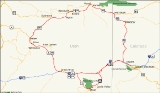
The Dinosaur Diamond Scenic Byway is a 512-mile National Scenic Byway
in the U.S. state
s of Utah
and Colorado
. The highway forms a diamond-shaped loop with vertices
at Moab
, Helper
, Vernal
and Grand Junction
.
The segment within Utah
is known as the Dinosaur Diamond Prehistoric Highway. The segment within Colorado
is known as the Dinosaur Diamond Scenic and Historic Byway. Notable features surrounding the Dinosaur Diamond include Dinosaur National Monument
, the Flaming Gorge National Recreation Area
, Canyonlands National Park
, Arches National Park
, Natural Bridges National Monument
, Colorado National Monument
, and several national forests.
The path of Interstate 70 in Colorado is derived from two previous highways, U.S. Highway 6 and U.S. Highway 40. US 40 was an original piece of the U.S. Highway system commissioned in 1926. The portion now numbered U.S. Highway 6 came about in 1937 when the route over Vail Pass
was paved. The first route through the path of Interstate 70 in Utah was the Old Spanish Trail
, a trade route between Santa Fe, New Mexico
and Los Angeles, California
. The trail was in common use before the Mexican-American War in 1848.
The easternmost starting point of the Dinosaur Diamond (DD) begins in Grand Junction, Colorado, on Interstate 70. In the vicinity of Grand Junction are the White River
, Uncompahgre
, and Grand Mesa National Forest
s. Other notable features nearby include the Powderhorn Resort
, and the geologic features of Book Cliffs
and Grand Mesa
.
 Traveling about 10 miles (16.1 km) westbound on I-70 will lead to Fruita, a small town within view of the Colorado National Monument
, which features numerous scenic hiking trails. From the trails, one may view attractions such as the Book Cliffs and Coke Ovens overlooks, and unique rock formations such as Independence Monument and the "Kissing Couple". Fruita is also the home of Mike the Headless Chicken
, and hosts an annual festival in his honor every May. A small statue dedicated to Mike can also be seen in the town.
Just west of Fruita, the byway turns north onto State Highway 139, traveling 78 miles (125.5 km) to the next town of Rangely, and traversing the Douglas Pass
. Nearby attractions include the Rangely Outdoor Museum and the Canyon Pintado ("painted canyon") Historic District petroglyph
s, which is listed on the National Register of Historic Places
.
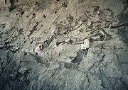
The byway continues 18 miles (29 km) northwest on State Highway 64, to the small town of Dinosaur. Nearby Dinosaur is the "crown jewel" of the DD, the Dinosaur National Monument
, which claims to be the most productive Jurassic Period dinosaur quarry in the world. The monument includes a walkway where visitors can view a sandstone
wall embedded with over 2,000 dinosaur bones, and watch paleontologists chip away the sandstone to expose the fossilized dinosaur bones. Visitors can also see the preparation laboratory where dinosaur fossil
s are cleaned and preserved.
Upon leaving Dinosaur, the DD continues west on U.S. Highway 40 and crosses the border into Utah.
 Traveling 34 miles (54.7 km) west of Dinosaur, Colorado, the Dinosaur Diamond encounters the small city of Vernal, Utah. Vernal borders the western end of the Dinosaur National Monument; other notable attractions nearby include Steinaker State Park
, Red Fleet State Park
, Flaming Gorge National Recreation Area
, and the Ashley National Forest
.
Continuing along the Dinosaur Diamond, U.S. Routes 40 and 191 converge within Vernal, heading west for 30 miles (48.3 km) to the city of Roosevelt
. Roosevelt is located on the edge of the Uintah and Ouray Indian Reservation
. Heading 29 miles (46.7 km) to the west is the county seat
of Duchesne
, located within the reservation. Nearby Duchesne are Starvation State Park
and Kings Peak
(the highest point in Utah), which is part of the Uinta Mountain range. The Uinta Mountains
are one of the few mountain ranges in the contiguous United States
which run east–west, and are the highest range to do so.
Within Duchesne, U.S. Routes 40 and 191 diverge, and the DD continues 55 miles (88.5 km) south along 191 over an un-named mountain pass
, through the small town of Helper, and into the larger city of Price
. The numerous attractions surrounding Price include College of Eastern Utah Prehistoric Museum
, Manti-La Sal National Forest
, Huntington Lake State Park, Scofield State Park, and Nine Mile Canyon
which features numerous petroglyphs. Also nearby is the Cleveland-Lloyd Dinosaur Quarry, a prehistoric mud trap which claims to be the densest concentration of Jurassic dinosaur fossils in the world.
Traveling 63 miles (101.4 km) southeast along U.S. Route 191, the DD encounters the city of Green River. Notable features surrounding Green River include the San Rafael Swell
, Green River State Park
, and Goblin Valley State Park
. Also nearby is Crystal Geyser
, a rare (but man-made) cold water geyser caused by the expansion of carbonized "soda pop" water within. Within Green River, U.S. Route 191 converges with Interstate 70 for a short while and diverges again, south towards the city of Moab, 55 miles (88.5 km) from Green River.
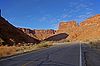
Just south of the junction of U.S. Route 191 and State Route 128, the city of Moab features a number of nearby attractions. Arches National Park
, Canyonlands National Park
, Dead Horse Point State Park
, and the Newspaper Rock
and Potash Road
petroglyphs.
Leaving Moab, the DD continues north along State Route 128 to its terminus with I-70 in Cisco. Traveling east along I-70, before completing the "diamond" back in Grand Junction, Colorado.
in 1998. The highway was approved as a National Scenic Byway
in 2002.
National Scenic Byways must go through a nomination procedure, and must already be designated as a state scenic byway in order to be nominated (However, roads that meet all criteria and
requirements for National designation but not State or designation criteria may be considered for national designation on a case-by-case basis).
To be considered for designation "a road or highway must significantly meet at least one of the six scenic byways intrinsic qualities". The qualities are scenic, natural, historic, cultural, archeological, or recreational. A "corridor management plan" must also be developed, with community involvement, and the plan "should provide for the conservation and enhancement of the byway's intrinsic qualities as well as the promotion of tourism and economic development". The final step is when the highway (or highways) is approved for designation by the Secretary of Transportation.
was paved. A portion of this route was also numbered U.S. Highway 24 at the time.
In the 1920s, Colorado State Highway 139 was an unimproved road from US 6 at Fruita north to State Highway 64 in Rangely.
 The first route through this portion of Utah was the Old Spanish Trail
, a trade route between Santa Fe, New Mexico
and Los Angeles, California
. The trail was in common use before the Mexican-American War in 1848. Although the trail serves a different route than I-70, they were both intended to connect southern California with points further east. I-70 generally parallels the route of the Old Spanish Trail west of Crescent Junction
.
The Utah State Road Commission
took over US Route 40 from Kimball Junction to Colorado in 1910 and 1911, and assigned the State Route 6 designation to this route by the mid-1920s. In late 1926, the American Association of State Highway Officials (AASHO) assigned the designation of US 40 to this cross-state route, consisting of most of SR-4 and all of SR-6. (The SR-6 designation remained until the 1977 renumbering; SR-4 became SR-2 in 1962 and was eliminated in favor of I-80 in 1977.)
The road connecting Colton
on SR-8 (US-50, now US-6) with SR-6 (US-40) in Duchesne became a state highway in 1910. The southwest end was moved from Colton to Castle Gate
in 1912, and in 1927 it was numbered State Route 33. Few changes were made to the roadway, and in 1981 it became part of US-191.
Access between Moab and Castle Valley was originally via a pack trail called the Heavenly Stairway. This trail, named for a dramatic descent of over 1000 feet (304.8 m), was described as beautiful, but difficult to navigate. Isolated from Utah's population centers, this area depended on Grand Junction
and other cities in Colorado for both everyday supplies and a market for agricultural products. Moab residents pushed for a road to be built along the riverbank. By 1902, the trail was replaced with a toll road, called King's Toll Road, after Samuel King. King was an early settler who also operated the toll ferry
used prior to the construction of the Dewey Bridge. Rocks inscribed with "Kings Toll Road" can still be found along the roadway. While the road did improve travel, it was not built high enough above the river level and was often flooded.
National Scenic Byway
A National Scenic Byway is a road recognized by the United States Department of Transportation for its archeological, cultural, historic, natural, recreational, and/or scenic qualities. The program was established by Congress in 1991 to preserve and protect the nation's scenic but often...
in the U.S. state
U.S. state
A U.S. state is any one of the 50 federated states of the United States of America that share sovereignty with the federal government. Because of this shared sovereignty, an American is a citizen both of the federal entity and of his or her state of domicile. Four states use the official title of...
s of Utah
Utah
Utah is a state in the Western United States. It was the 45th state to join the Union, on January 4, 1896. Approximately 80% of Utah's 2,763,885 people live along the Wasatch Front, centering on Salt Lake City. This leaves vast expanses of the state nearly uninhabited, making the population the...
and Colorado
Colorado
Colorado is a U.S. state that encompasses much of the Rocky Mountains as well as the northeastern portion of the Colorado Plateau and the western edge of the Great Plains...
. The highway forms a diamond-shaped loop with vertices
Vertex (geometry)
In geometry, a vertex is a special kind of point that describes the corners or intersections of geometric shapes.-Of an angle:...
at Moab
Moab, Utah
Moab is a city in Grand County, in eastern Utah, in the western United States. The population was 4,779 at the 2000 census. It is the county seat and largest city in Grand County. Moab hosts a large number of tourists every year, mostly visitors to the nearby Arches and Canyonlands National Parks...
, Helper
Helper, Utah
Helper is a city in Carbon County, Utah, United States about 120 miles southeast of Salt Lake City and northwest of the city of Price. It is also known as the "Hub of Carbon County". The population was 2,025 at the 2000 census....
, Vernal
Vernal, Utah
Vernal, Uintah County's largest city, is located in eastern Utah near the Colorado State Line, and 175 miles east of Salt Lake City. It is bordered on the north by the Uinta Mountains, one of the few mountains ranges in the world which lie in an east-west rather than the usual north to south...
and Grand Junction
Grand Junction, Colorado
The City of Grand Junction is the largest city in western Colorado. It is a city with a council–manager government form that is the county seat and the most populous city of Mesa County, Colorado, United States. Grand Junction is situated west-southwest of the Colorado State Capitol in Denver. As...
.
The segment within Utah
Utah
Utah is a state in the Western United States. It was the 45th state to join the Union, on January 4, 1896. Approximately 80% of Utah's 2,763,885 people live along the Wasatch Front, centering on Salt Lake City. This leaves vast expanses of the state nearly uninhabited, making the population the...
is known as the Dinosaur Diamond Prehistoric Highway. The segment within Colorado
Colorado
Colorado is a U.S. state that encompasses much of the Rocky Mountains as well as the northeastern portion of the Colorado Plateau and the western edge of the Great Plains...
is known as the Dinosaur Diamond Scenic and Historic Byway. Notable features surrounding the Dinosaur Diamond include Dinosaur National Monument
Dinosaur National Monument
Dinosaur National Monument is a National Monument located on the southeast flank of the Uinta Mountains on the border between Colorado and Utah at the confluence of the Green and Yampa Rivers. Although most of the monument area is in Moffat County, Colorado, the Dinosaur Quarry is located in Utah...
, the Flaming Gorge National Recreation Area
Flaming Gorge National Recreation Area
Flaming Gorge National Recreation Area is a United States National Recreation Area located in the states of Wyoming and Utah. The centerpiece of the recreation area is the 91 mile long Flaming Gorge Reservoir, a reservoir created by the Flaming Gorge Dam along the Green River in 1964...
, Canyonlands National Park
Canyonlands National Park
Canyonlands National Park is a U.S. National Park located in southeastern Utah near the town of Moab and preserves a colorful landscape eroded into countless canyons, mesas and buttes by the Colorado River, the Green River, and their respective tributaries. The park is divided into four districts:...
, Arches National Park
Arches National Park
Arches National Park is a U.S. National Park in eastern Utah. It is known for preserving over 2000 natural sandstone arches, including the world-famous Delicate Arch, in addition to a variety of unique geological resources and formations....
, Natural Bridges National Monument
Natural Bridges National Monument
Natural Bridges National Monument is a U.S. National Monument located about north west of the Four Corners boundary of southeast Utah, in the western United States, at the junction of White Canyon and Armstrong Canyon, part of the Colorado River drainage...
, Colorado National Monument
Colorado National Monument
- Trails :The Monument contains many hiking trails, with lengths and difficulties to suit all tastes. Summer storms can cause flash floods as well as dangerous trail conditions. Rattlesnakes are found on the Monument, and rough terrain exists everywhere, but most trails are well-maintained...
, and several national forests.
The path of Interstate 70 in Colorado is derived from two previous highways, U.S. Highway 6 and U.S. Highway 40. US 40 was an original piece of the U.S. Highway system commissioned in 1926. The portion now numbered U.S. Highway 6 came about in 1937 when the route over Vail Pass
Vail Pass
Vail Pass is a high mountain pass in the Rocky Mountains of central Colorado. The pass was named for Charles Vail, a highway engineer.Vail Pass lies on the boundary between Eagle and Summit counties, between Vail on the west and Copper Mountain on the east. It provides the route of Interstate 70...
was paved. The first route through the path of Interstate 70 in Utah was the Old Spanish Trail
Old Spanish Trail (trade route)
The Old Spanish Trail is a historical trade route which connected the northern New Mexico settlements near or in Santa Fe, New Mexico with that of Los Angeles, California and southern California. Approximately long, it ran through areas of high mountains, arid deserts, and deep canyons. It is...
, a trade route between Santa Fe, New Mexico
Santa Fe, New Mexico
Santa Fe is the capital of the U.S. state of New Mexico. It is the fourth-largest city in the state and is the seat of . Santa Fe had a population of 67,947 in the 2010 census...
and Los Angeles, California
Los Angeles, California
Los Angeles , with a population at the 2010 United States Census of 3,792,621, is the most populous city in California, USA and the second most populous in the United States, after New York City. It has an area of , and is located in Southern California...
. The trail was in common use before the Mexican-American War in 1848.
Colorado
The following Colorado routes are included in the Colorado portion of the Dinosaur Diamond Scenic and Historic Byway:-
 Interstate 70Interstate 70 in ColoradoInterstate 70 is a transcontinental Interstate Highway in the United States, stretching from Cove Fort, Utah to Baltimore, Maryland. In Colorado, the highway traverses an east–west route across the center of the state. In western Colorado, the highway connects the metropolitan areas of Grand...
between Grand JunctionGrand Junction, ColoradoThe City of Grand Junction is the largest city in western Colorado. It is a city with a council–manager government form that is the county seat and the most populous city of Mesa County, Colorado, United States. Grand Junction is situated west-southwest of the Colorado State Capitol in Denver. As...
and the Utah state line. (I-70 runs concurrentConcurrency (road)A concurrency, overlap, or coincidence in a road network is an instance of one physical road bearing two or more different highway, motorway, or other route numbers...
with U.S. Highway 6 and U.S. Highway 50 in this area) -
 U.S. Route 40 between DinosaurDinosaur, ColoradoThe Town of Dinosaur is a Statutory Town located in Moffat County, Colorado, United States. The town population was 320 at the U.S. Census 2000....
and the Utah state line -
 State Highway 64Colorado State Highway 64State Highway 64 is a 74-mile long two-lane state highway connecting the towns of Dinosaur and Meeker in the western part of the U.S. state of Colorado. It is located in both Moffat and Rio Blanco counties. The western end of State Highway 64 is part of the Dinosaur Diamond Scenic Byway, while the...
between Dinosaur and RangelyRangely, ColoradoRangely is a Statutory Town in Rio Blanco County, Colorado, United States. The population was 2,096 at the 2000 census. The town is home to one of two campuses of the Colorado Northwestern Community College.-Geography:... -
 State Highway 139Colorado State Highway 139State Highway 139 is a long state highway in far western Colorado.-Route description:SH 139 begins in the south at exit 15 of Interstate 70 at Loma roughly fifteen miles west of Grand Junction. From there the road proceeds northward through very remote, very sparsely populated land to its...
between FruitaFruita, ColoradoThe City of Fruita is a Home Rule Municipality located in the western part of Mesa County, Colorado, in the United States. It is part of the Grand Junction Metropolitan Statistical Area and within the Grand Valley...
and Rangely
The easternmost starting point of the Dinosaur Diamond (DD) begins in Grand Junction, Colorado, on Interstate 70. In the vicinity of Grand Junction are the White River
White River National Forest
White River National Forest is a National Forest in northwest Colorado. It is named after the White River that passes through it. It also contains the Flat Tops Wilderness Area, largely considered the birthplace of the U.S...
, Uncompahgre
Uncompahgre National Forest
Uncompahgre National Forest is a U.S. National Forest covering 955,229 acres in parts of Montrose, Mesa, San Miguel, Ouray, Gunnison, San Juan, and Delta Counties in western Colorado...
, and Grand Mesa National Forest
Grand Mesa National Forest
The Grand Mesa National Forest is a U.S. National Forest in Mesa, Delta and Garfield Counties in Western Colorado. It borders the White River National Forest to the north and the Gunnison National Forest to the east. The forest covers most of Grand Mesa and the south part of Battlement Mesa. It...
s. Other notable features nearby include the Powderhorn Resort
Powderhorn Resort
Powderhorn Resort is located 45 minutes east of Grand Junction, Colorado on the Grand Mesa. The area has a variety of ski terrain such as groomers, bumps, glades, and boulder fields. Powderhorn is unique among Colorado ski resorts because of its terrain and climate...
, and the geologic features of Book Cliffs
Book Cliffs
The Book Cliffs are a series of mountains and cliffs in western Colorado and eastern Utah, in the western United States. They are so named because many of them have the triangular appearance of a book that has been opened up, then turned on its sides and set to rest on the open sides of the book,...
and Grand Mesa
Grand Mesa
The Grand Mesa is a large mesa in western Colorado in the United States. It has an area of about and stretches for about east of Grand Junction between the Colorado River and the Gunnison River, its tributary to the south. The north side of the mesa is drained largely by Plateau Creek, a...
.
Colorado National Monument
- Trails :The Monument contains many hiking trails, with lengths and difficulties to suit all tastes. Summer storms can cause flash floods as well as dangerous trail conditions. Rattlesnakes are found on the Monument, and rough terrain exists everywhere, but most trails are well-maintained...
, which features numerous scenic hiking trails. From the trails, one may view attractions such as the Book Cliffs and Coke Ovens overlooks, and unique rock formations such as Independence Monument and the "Kissing Couple". Fruita is also the home of Mike the Headless Chicken
Mike the Headless Chicken
Mike the Headless Chicken , also known as Miracle Mike, was a Wyandotte chicken that lived for 18 months after his head had been mostly cut off...
, and hosts an annual festival in his honor every May. A small statue dedicated to Mike can also be seen in the town.
Just west of Fruita, the byway turns north onto State Highway 139, traveling 78 miles (125.5 km) to the next town of Rangely, and traversing the Douglas Pass
Douglas Pass
Douglas Pass is a mountain pass in Colorado traversed by State Highway 139. It is not an especially high summit relative to other Colorado passes, and the road, though reasonably steep on the south side , has no tight spots and only a few switchbacks...
. Nearby attractions include the Rangely Outdoor Museum and the Canyon Pintado ("painted canyon") Historic District petroglyph
Petroglyph
Petroglyphs are pictogram and logogram images created by removing part of a rock surface by incising, picking, carving, and abrading. Outside North America, scholars often use terms such as "carving", "engraving", or other descriptions of the technique to refer to such images...
s, which is listed on the National Register of Historic Places
National Register of Historic Places
The National Register of Historic Places is the United States government's official list of districts, sites, buildings, structures, and objects deemed worthy of preservation...
.
The byway continues 18 miles (29 km) northwest on State Highway 64, to the small town of Dinosaur. Nearby Dinosaur is the "crown jewel" of the DD, the Dinosaur National Monument
Dinosaur National Monument
Dinosaur National Monument is a National Monument located on the southeast flank of the Uinta Mountains on the border between Colorado and Utah at the confluence of the Green and Yampa Rivers. Although most of the monument area is in Moffat County, Colorado, the Dinosaur Quarry is located in Utah...
, which claims to be the most productive Jurassic Period dinosaur quarry in the world. The monument includes a walkway where visitors can view a sandstone
Sandstone
Sandstone is a sedimentary rock composed mainly of sand-sized minerals or rock grains.Most sandstone is composed of quartz and/or feldspar because these are the most common minerals in the Earth's crust. Like sand, sandstone may be any colour, but the most common colours are tan, brown, yellow,...
wall embedded with over 2,000 dinosaur bones, and watch paleontologists chip away the sandstone to expose the fossilized dinosaur bones. Visitors can also see the preparation laboratory where dinosaur fossil
Fossil
Fossils are the preserved remains or traces of animals , plants, and other organisms from the remote past...
s are cleaned and preserved.
Upon leaving Dinosaur, the DD continues west on U.S. Highway 40 and crosses the border into Utah.
Utah
The Utah portion of the Dinosaur Diamond Prehistoric Highway is routed along these highways:- Interstate 70Interstate 70 in UtahInterstate 70 is a mainline route of the Interstate Highway System in the United States connecting Utah and Maryland. The Utah section runs east–west for across the central part of the state. Richfield is the largest Utah city served by the freeway, which does not serve or connect any urban areas...
Between Colorado state line and CiscoCisco, UtahCisco is a ghost town in Grand County, Utah near the junction of State Route 128 and Interstate 70. At one time the town served as a saloon and water-refilling station for the Denver and Rio Grande Western Railroad. The town's demise came with the demise of the steam locomotive. The town site...
, again from Crescent JunctionCrescent Junction, UtahCrescent Junction is a small unincorporated community within Grand County in the eastern part of the U.S. state of Utah. The community is located at above sea level. Most highway maps use the name Crescent Junction, as the name given to the junction of Interstate 70 and U.S. Route 191...
to Green RiverGreen River, UtahGreen River is a city in Emery County, Utah, United States. The population was 973 at the 2000 census.-Geography:Green River is located at , on the banks of the Green River, after which the city is named. The San Rafael Swell region is to the west of Green River, while Canyonlands National Park...
(I-70 runs concurrentConcurrency (road)A concurrency, overlap, or coincidence in a road network is an instance of one physical road bearing two or more different highway, motorway, or other route numbers...
with U.S. Route 6 and U.S. Route 50 in this area) -
 U.S. Route 6 from Green River to HelperHelper, UtahHelper is a city in Carbon County, Utah, United States about 120 miles southeast of Salt Lake City and northwest of the city of Price. It is also known as the "Hub of Carbon County". The population was 2,025 at the 2000 census....
 - U.S. Route 40 from VernalVernal, UtahVernal, Uintah County's largest city, is located in eastern Utah near the Colorado State Line, and 175 miles east of Salt Lake City. It is bordered on the north by the Uinta Mountains, one of the few mountains ranges in the world which lie in an east-west rather than the usual north to south...
to Colorado state line -
 U.S. Route 191 from MoabMoab, UtahMoab is a city in Grand County, in eastern Utah, in the western United States. The population was 4,779 at the 2000 census. It is the county seat and largest city in Grand County. Moab hosts a large number of tourists every year, mostly visitors to the nearby Arches and Canyonlands National Parks...
to Vernal -
 State Route 128Utah State Route 128State Route 128 is a state highway in the U.S. state of Utah. The entire length of the highway has been designated the Upper Colorado River Scenic Byway, as part of the Utah Scenic Byways program. This road also forms part of the Dinosaur Diamond Prehistoric Highway, a National Scenic Byway...
from Cisco to Moab
Steinaker State Park
Steinaker State Park is a state park and reservoir of Utah, USA, located north of Vernal in Uintah County, Utah.Steinaker State Park opened to the public in 1964. It lies at an elevation of in northeastern Utah, south of the Uinta Mountains. The climate is arid with hot summers and cold winters....
, Red Fleet State Park
Red Fleet State Park
Red Fleet State Park is a state park of Utah, USA, featuring a reservoir and a fossil trackway of dinosaur footprints. The park is located north of Vernal.-Geography:...
, Flaming Gorge National Recreation Area
Flaming Gorge National Recreation Area
Flaming Gorge National Recreation Area is a United States National Recreation Area located in the states of Wyoming and Utah. The centerpiece of the recreation area is the 91 mile long Flaming Gorge Reservoir, a reservoir created by the Flaming Gorge Dam along the Green River in 1964...
, and the Ashley National Forest
Ashley National Forest
Ashley National Forest is a national forest located in northeastern Utah and southwestern Wyoming. Within the Forest’s bounds are of vast forests, lakes, and mountains, with elevations ranging from . The Forest covers portions of Utah; Duchesne; Uintah; Daggett; and Summit counties in Utah and...
.
Continuing along the Dinosaur Diamond, U.S. Routes 40 and 191 converge within Vernal, heading west for 30 miles (48.3 km) to the city of Roosevelt
Roosevelt, Utah
Roosevelt is a city in Duchesne County, Utah, United States. The population was 4,299 at the 2000 census.The proper pronunciation of the city's name is based on how President Theodore Roosevelt pronounced his name: according to the man himself, "pronounced as if it was spelled...
. Roosevelt is located on the edge of the Uintah and Ouray Indian Reservation
Uintah and Ouray Indian Reservation
The Uintah and Ouray Indian Reservation is located in northeastern Utah, USA. It is the homeland of the Northern Ute Tribe, and is the largest of three Indian reservations inhabited by members of the Ute Tribe of Native Americans. It lies in parts of seven counties; in descending order of land area...
. Heading 29 miles (46.7 km) to the west is the county seat
County seat
A county seat is an administrative center, or seat of government, for a county or civil parish. The term is primarily used in the United States....
of Duchesne
Duchesne, Utah
Duchesne is a city in and the county seat of Duchesne County, Utah, United States. The population was 1,690 at the 2010 census.-Geography:Duchesne city is located at . just west of the junction of the Strawberry and Duchesne rivers in the Uintah Basin of northeastern Utah...
, located within the reservation. Nearby Duchesne are Starvation State Park
Starvation State Park
Starvation State Park and Reservoir is a state park in northeastern Utah, USA, featuring a reservoir. The park is northwest of the town of Duchesne, Utah.-Facilities:...
and Kings Peak
Kings Peak
For the mountain in Idaho, see Kings Peak .Kings Peak is the highest peak in the U.S. state of Utah,with an elevation of . It lies just south of the spine of the central Uinta Mountains, in the Ashley National Forest in northeastern Utah, in north-central Duchesne County. It is also located in the...
(the highest point in Utah), which is part of the Uinta Mountain range. The Uinta Mountains
Uinta Mountains
The Uinta Mountains are a high chain of mountains in northeastern Utah and extreme northwestern Colorado in the United States. A subrange of the Rocky Mountains, they are unusual for being the highest range in the contiguous United States running east to west, and lie approximately east of Salt...
are one of the few mountain ranges in the contiguous United States
Contiguous United States
The contiguous United States are the 48 U.S. states on the continent of North America that are south of Canada and north of Mexico, plus the District of Columbia....
which run east–west, and are the highest range to do so.
Within Duchesne, U.S. Routes 40 and 191 diverge, and the DD continues 55 miles (88.5 km) south along 191 over an un-named mountain pass
Mountain pass
A mountain pass is a route through a mountain range or over a ridge. If following the lowest possible route, a pass is locally the highest point on that route...
, through the small town of Helper, and into the larger city of Price
Price, Utah
Price is a city in Carbon County, Utah, United States. The city is home to the USU-College of Eastern Utah, as well as the large USU Eastern Prehistoric Museum affiliated with the college. Price is located within short distances from both Nine Mile Canyon and the Manti-La Sal National Forest...
. The numerous attractions surrounding Price include College of Eastern Utah Prehistoric Museum
College of Eastern Utah Prehistoric Museum
The USU Eastern Prehistoric Museum, formerly known as the College of Eastern Utah Prehistoric Museum, is a museum accredited by the American Association of Museums located in Price, Utah. The museum seeks to promote public understanding of prehistory through interpretive exhibits, educational...
, Manti-La Sal National Forest
Manti-La Sal National Forest
The Manti-La Sal National Forest covers 1,270,646 acres and is located in the central and southeastern parts of the U.S. state of Utah and the extreme western part of Colorado...
, Huntington Lake State Park, Scofield State Park, and Nine Mile Canyon
Nine Mile Canyon
Nine Mile Canyon is a canyon, approximately long, located in the counties of Carbon and Duchesne in eastern Utah, in the Western United States. Promoted as "the world’s longest art gallery," the canyon is known for its extensive rock art, most of it created by the Fremont culture and the Ute people...
which features numerous petroglyphs. Also nearby is the Cleveland-Lloyd Dinosaur Quarry, a prehistoric mud trap which claims to be the densest concentration of Jurassic dinosaur fossils in the world.
Traveling 63 miles (101.4 km) southeast along U.S. Route 191, the DD encounters the city of Green River. Notable features surrounding Green River include the San Rafael Swell
San Rafael Swell
The San Rafael Swell is a large geologic feature located in south-central Utah, USA about 30 miles west of Green River, Utah. The San Rafael Swell, approximately by , consists of a giant dome-shaped anticline of sandstone, shale, and limestone that was pushed up during the Paleocene Laramide...
, Green River State Park
Green River State Park
Green River State Park is a state park of Utah, USA, located in the town of Green River. The park consists of a nine-hole golf course, a campground shaded with cottonwood trees, and a boat ramp. The Green River hosts catfish, carp, and four unique native fish that are threatened with extinction...
, and Goblin Valley State Park
Goblin Valley State Park
Goblin Valley State Park is a state park of Utah, USA.Its eminent feature is its thousands of hoodoos and hoodoo rocks, which are formations of mushroom-shaped rock pinnacles, some as high as several meters...
. Also nearby is Crystal Geyser
Crystal Geyser
Crystal Geyser is located on the east bank of the Green River approximately 4.5 miles downstream from Green River, Utah. It is a rare example of a cold water carbon dioxide driven geyser; geothermal activity does not play a role in the activity of the geyser...
, a rare (but man-made) cold water geyser caused by the expansion of carbonized "soda pop" water within. Within Green River, U.S. Route 191 converges with Interstate 70 for a short while and diverges again, south towards the city of Moab, 55 miles (88.5 km) from Green River.
Just south of the junction of U.S. Route 191 and State Route 128, the city of Moab features a number of nearby attractions. Arches National Park
Arches National Park
Arches National Park is a U.S. National Park in eastern Utah. It is known for preserving over 2000 natural sandstone arches, including the world-famous Delicate Arch, in addition to a variety of unique geological resources and formations....
, Canyonlands National Park
Canyonlands National Park
Canyonlands National Park is a U.S. National Park located in southeastern Utah near the town of Moab and preserves a colorful landscape eroded into countless canyons, mesas and buttes by the Colorado River, the Green River, and their respective tributaries. The park is divided into four districts:...
, Dead Horse Point State Park
Dead Horse Point State Park
Dead Horse Point State Park is a state park of Utah, USA, featuring a dramatic overlook of the Colorado River and Canyonlands National Park. The park is so named because of its use as a natural corral by cowboys in the 19th century...
, and the Newspaper Rock
Newspaper Rock State Historic Monument
Newspaper Rock State Historic Monument is in eastern Utah, western United States, located to the east of Canyonlands National Park on Hwy 211. It is 28 miles northwest of Monticello and 53 miles south of Moab...
and Potash Road
Utah State Route 279
State Route 279 is a state highway in the U.S. state of Utah. The highway was constructed in 1962–1963 to service the Cane Creek potash mine and processing plant southwest of Moab. The highway was named one of the most beautiful highways opened to traffic in 1963...
petroglyphs.
Leaving Moab, the DD continues north along State Route 128 to its terminus with I-70 in Cisco. Traveling east along I-70, before completing the "diamond" back in Grand Junction, Colorado.
History
The segment within Colorado was designated the Dinosaur Diamond Scenic and Historic Byway by the Colorado Transportation Commission in 1997. The segment within Utah was designated the Dinosaur Diamond Prehistoric Highway by the Utah State LegislatureUtah State Legislature
The Utah State Legislature is the state legislature of the U.S. state of Utah. It is a bicameral body, comprising the Utah House of Representatives, with 75 Representatives, and the Utah Senate, with 29 State Senators...
in 1998. The highway was approved as a National Scenic Byway
National Scenic Byway
A National Scenic Byway is a road recognized by the United States Department of Transportation for its archeological, cultural, historic, natural, recreational, and/or scenic qualities. The program was established by Congress in 1991 to preserve and protect the nation's scenic but often...
in 2002.
National Scenic Byways must go through a nomination procedure, and must already be designated as a state scenic byway in order to be nominated (However, roads that meet all criteria and
requirements for National designation but not State or designation criteria may be considered for national designation on a case-by-case basis).
To be considered for designation "a road or highway must significantly meet at least one of the six scenic byways intrinsic qualities". The qualities are scenic, natural, historic, cultural, archeological, or recreational. A "corridor management plan" must also be developed, with community involvement, and the plan "should provide for the conservation and enhancement of the byway's intrinsic qualities as well as the promotion of tourism and economic development". The final step is when the highway (or highways) is approved for designation by the Secretary of Transportation.
Colorado history
The path of I-70 in Colorado is derived from two previous highways, U.S. Highway 6 and U.S. Highway 40. US 40 was an original piece of the U.S. Highway system commissioned in 1926. The portion now numbered U.S. Highway 6 came about in 1937 when the route over Vail PassVail Pass
Vail Pass is a high mountain pass in the Rocky Mountains of central Colorado. The pass was named for Charles Vail, a highway engineer.Vail Pass lies on the boundary between Eagle and Summit counties, between Vail on the west and Copper Mountain on the east. It provides the route of Interstate 70...
was paved. A portion of this route was also numbered U.S. Highway 24 at the time.
In the 1920s, Colorado State Highway 139 was an unimproved road from US 6 at Fruita north to State Highway 64 in Rangely.
Utah history
Old Spanish Trail (trade route)
The Old Spanish Trail is a historical trade route which connected the northern New Mexico settlements near or in Santa Fe, New Mexico with that of Los Angeles, California and southern California. Approximately long, it ran through areas of high mountains, arid deserts, and deep canyons. It is...
, a trade route between Santa Fe, New Mexico
Santa Fe, New Mexico
Santa Fe is the capital of the U.S. state of New Mexico. It is the fourth-largest city in the state and is the seat of . Santa Fe had a population of 67,947 in the 2010 census...
and Los Angeles, California
Los Angeles, California
Los Angeles , with a population at the 2010 United States Census of 3,792,621, is the most populous city in California, USA and the second most populous in the United States, after New York City. It has an area of , and is located in Southern California...
. The trail was in common use before the Mexican-American War in 1848. Although the trail serves a different route than I-70, they were both intended to connect southern California with points further east. I-70 generally parallels the route of the Old Spanish Trail west of Crescent Junction
Crescent Junction, Utah
Crescent Junction is a small unincorporated community within Grand County in the eastern part of the U.S. state of Utah. The community is located at above sea level. Most highway maps use the name Crescent Junction, as the name given to the junction of Interstate 70 and U.S. Route 191...
.
The Utah State Road Commission
Utah State Road Commission
The Utah Transportation Commission oversees the Utah Department of Transportation....
took over US Route 40 from Kimball Junction to Colorado in 1910 and 1911, and assigned the State Route 6 designation to this route by the mid-1920s. In late 1926, the American Association of State Highway Officials (AASHO) assigned the designation of US 40 to this cross-state route, consisting of most of SR-4 and all of SR-6. (The SR-6 designation remained until the 1977 renumbering; SR-4 became SR-2 in 1962 and was eliminated in favor of I-80 in 1977.)
The road connecting Colton
Colton, Utah
-External links:* at GhostTowns.com* at Legends of America...
on SR-8 (US-50, now US-6) with SR-6 (US-40) in Duchesne became a state highway in 1910. The southwest end was moved from Colton to Castle Gate
Castle Gate, Utah
Castle Gate is a ghost town located in Carbon County in eastern Utah, USA. Castle Gate was a mining town approximately southeast of Salt Lake City, Utah. The name of the town was derived from a rock formation near the mouth of Price Canyon...
in 1912, and in 1927 it was numbered State Route 33. Few changes were made to the roadway, and in 1981 it became part of US-191.
Access between Moab and Castle Valley was originally via a pack trail called the Heavenly Stairway. This trail, named for a dramatic descent of over 1000 feet (304.8 m), was described as beautiful, but difficult to navigate. Isolated from Utah's population centers, this area depended on Grand Junction
Grand Junction, Colorado
The City of Grand Junction is the largest city in western Colorado. It is a city with a council–manager government form that is the county seat and the most populous city of Mesa County, Colorado, United States. Grand Junction is situated west-southwest of the Colorado State Capitol in Denver. As...
and other cities in Colorado for both everyday supplies and a market for agricultural products. Moab residents pushed for a road to be built along the riverbank. By 1902, the trail was replaced with a toll road, called King's Toll Road, after Samuel King. King was an early settler who also operated the toll ferry
Ferry
A ferry is a form of transportation, usually a boat, but sometimes a ship, used to carry primarily passengers, and sometimes vehicles and cargo as well, across a body of water. Most ferries operate on regular, frequent, return services...
used prior to the construction of the Dewey Bridge. Rocks inscribed with "Kings Toll Road" can still be found along the roadway. While the road did improve travel, it was not built high enough above the river level and was often flooded.