

Manti-La Sal National Forest
Encyclopedia
U.S. state
A U.S. state is any one of the 50 federated states of the United States of America that share sovereignty with the federal government. Because of this shared sovereignty, an American is a citizen both of the federal entity and of his or her state of domicile. Four states use the official title of...
of Utah
Utah
Utah is a state in the Western United States. It was the 45th state to join the Union, on January 4, 1896. Approximately 80% of Utah's 2,763,885 people live along the Wasatch Front, centering on Salt Lake City. This leaves vast expanses of the state nearly uninhabited, making the population the...
and the extreme western part of Colorado
Colorado
Colorado is a U.S. state that encompasses much of the Rocky Mountains as well as the northeastern portion of the Colorado Plateau and the western edge of the Great Plains...
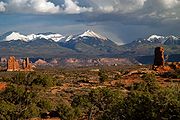
. The forest is divided into three districts: the La Sal District at Moab in the La Sal Range
La Sal Range
The La Sal Mountains are located in Grand and San Juan counties, near the eastern border of the state of Utah, and rising above the town of Moab. This range is part of the Manti-La Sal National Forest and the southern Rocky Mountains. The maximum elevation is at Mount Peale, reaching 12,721 feet ...
near Moab
Moab, Utah
Moab is a city in Grand County, in eastern Utah, in the western United States. The population was 4,779 at the 2000 census. It is the county seat and largest city in Grand County. Moab hosts a large number of tourists every year, mostly visitors to the nearby Arches and Canyonlands National Parks...
, in the La Sal District at Monticello in the Abajo Mountains
Abajo Mountains
The Abajo Mountains, also called the Blue Mountains, is a small mountain range west of Monticello, Utah, south of Canyonlands National Park and north of Blanding, Utah. The mountain range is located within the Manti-La Sal National Forest...
west of Monticello
Monticello, Utah
Monticello is a city located in San Juan County, Utah, and is the county seat. It is the second most populous city in San Juan County, with a population of 1,958 at the 2000 census. The Monticello area was settled in July 1887 by pioneers from The Church of Jesus Christ of Latter-day Saints...
, and the Manti Division on the Wasatch Plateau west of Price
Price, Utah
Price is a city in Carbon County, Utah, United States. The city is home to the USU-College of Eastern Utah, as well as the large USU Eastern Prehistoric Museum affiliated with the college. Price is located within short distances from both Nine Mile Canyon and the Manti-La Sal National Forest...
. The maximum elevation is Mount Peale
Mount Peale
Mount Peale is the highest point in the La Sal Mountains of San Juan County, in the southeastern part of the US state of Utah. It is also the highest point in Utah outside the Uinta Mountains. It is located about southeast of Moab...
in the La Sal Mountains, reaching 12,721 feet (3,877 m) above sea level. The La Sal's are the second highest mountain range in Utah after the Uintas.
The La Sal Mountain loop road leads from Castle Valley
Castle Valley, Utah
Castle Valley is a town in Grand County, Utah, United States. The population was 349 at the 2000 census. The town is about 16 miles northeast of Moab near State Route 128.-Geography:Castle Valley is located at ....
to Geyser Pass
Geyser Pass
Geyser Pass is a mountain pass in the La Sal Range of Utah. The pass is not named after a geyser, but for cattleman Al Geyser, who grazed his stock in the area in the 1880s....
and back down to Moab. Scenic Oowah Lake can be found within the forest.

San Juan County, Utah
As of the current census of 2010, there were 14,746 people and 4,505 households. The racial and ethnic composition of the population was 50.4% Native American, 45.8% white, 0.3% Asian, 0.2% African American and 2.3% reporting two or more races...
, Sanpete
Sanpete County, Utah
Sanpete County is a county located in the U.S. state of Utah. The population according to the 2010 U.S. Census was 27,822. It was possibly named for a Ute Indian chief named Sanpitch, which was corrupted to Sanpete. Its county seat is Manti and its largest city is Ephraim.-Geography:According to...
, Emery
Emery County, Utah
Emery County is a county located in the U.S. state of Utah. As of 2000 the population was 10,860, and by 2009 had been estimated to decrease to 10,629. It was named for George W. Emery, governor of the Utah Territory in 1875...
, Utah
Utah County, Utah
Utah County is a county located in the U.S. state of Utah. As of 2000, the population was 368,536 and by 2008 was estimated at 530,837. It was named for the Spanish name for the Ute Indians. The county seat and largest city is Provo...
, Grand
Grand County, Utah
Grand County is a county located in the U.S. state of Utah. As of 2000 the population was 8,485, and by 2005 had been estimated at 8,743. It was named for the Colorado River, which at the time of statehood was known as the Grand River. Its county seat and largest city is Moab.-Geography:According...
, Carbon
Carbon County, Utah
Carbon County is a county located in the U.S. state of Utah. Named for the major coal deposits in the area, the county seat and largest city, is Price. Carbon County is the second largest natural gas producer in Utah , with 94 billion cubic feet produced in 2008. As of 2010 the population was...
, and Sevier
Sevier County, Utah
As of the census of 2000, there were 18,842 people, 6,081 households, and 4,907 families residing in the county. The population density was 10 people per square mile . There were 7,016 housing units at an average density of 4 per square mile...
counties in Utah, as well as Montrose
Montrose County, Colorado
Montrose County is the 17th most populous of the 64 counties of the State of Colorado of the United States. The county population was 41,276 at U.S. Census 2010. The county was named for its county seat, the City of Montrose...
, and Mesa
Mesa County, Colorado
Mesa County is the fourth most extensive and the eleventh most populous of the 64 counties of the state of Colorado in the United States. The county was named for the many large mesas in the area, including Grand Mesa. The county population was 146,723 at the 2010 United States Census. The...
counties in Colorado. Only about 2.1% of the forest lies in Colorado.) Forest headquarters is located in Price, Utah
Price, Utah
Price is a city in Carbon County, Utah, United States. The city is home to the USU-College of Eastern Utah, as well as the large USU Eastern Prehistoric Museum affiliated with the college. Price is located within short distances from both Nine Mile Canyon and the Manti-La Sal National Forest...
. There are local ranger
National Park Ranger
National Park Service Rangers are among the uniformed employees charged with protecting and preserving areas set aside in the National Park System by the United States Congress and/or the President of the United States...
district offices in Ephraim
Ephraim, Utah
Ephraim is a city in Sanpete County, Utah, United States. The population was 6,135 at the 2010 census, making it the largest city in Sanpete County. It is the location of Snow College and is located along U.S. Route 89.-History:Ephraim was founded in 1854...
, Ferron
Ferron, Utah
Ferron is a city in Emery County, Utah, United States. The population was 1,623 at the 2000 census.-Geography:Ferron is located at ....
, Moab
Moab, Utah
Moab is a city in Grand County, in eastern Utah, in the western United States. The population was 4,779 at the 2000 census. It is the county seat and largest city in Grand County. Moab hosts a large number of tourists every year, mostly visitors to the nearby Arches and Canyonlands National Parks...
, Monticello
Monticello, Utah
Monticello is a city located in San Juan County, Utah, and is the county seat. It is the second most populous city in San Juan County, with a population of 1,958 at the 2000 census. The Monticello area was settled in July 1887 by pioneers from The Church of Jesus Christ of Latter-day Saints...
, and Price.
The forest was originally established as the Manti Forest Reserve by the General Land Office
General Land Office
The General Land Office was an independent agency of the United States government responsible for public domain lands in the United States. It was created in 1812 to take over functions previously conducted by the United States Department of the Treasury...
on May 29, 1903 with 584640 acres (2,366 km²). On July 1, 1915 Nebo National Forest
Nebo National Forest
Nebo National Forest was established by the U.S. Forest Service in Utah on July 1, 1908 with from the consolidation of Payson and Vernon National Forests and part of Fillmore. On July 1, 1915 the entire forest was transferred to Manti National Forest. The lands presently exist in Manti-La Sal...
was added, and La Sal National Forest
La Sal National Forest
La Sal National Forest was established as the La Sal Forest Reseve by the U.S. Forest Service in Utah and Colorado on January 25, 1906 with , mostly in Utah. It became a National Forest on March 4, 1907. On July 1, 1908 it was combined with Monticello National Forest and renamed La Salle National...
on November 11, 1949. On August 28, 1958 the name became Manti-La Sal National Forest.
Manti La Sal National Forest is very popular for recreation. The northern district on the Wasatch Plateau is well known for the Skyline Drive, an unpaved road tracing along the backbone of the plateau. There is also an extensive ATV trail system in the forest there. The Moab District in the La Sal Mountains contains excellent hiking, as well as spectacular views over the desert regions of Canyonlands National Park
Canyonlands National Park
Canyonlands National Park is a U.S. National Park located in southeastern Utah near the town of Moab and preserves a colorful landscape eroded into countless canyons, mesas and buttes by the Colorado River, the Green River, and their respective tributaries. The park is divided into four districts:...
and Arches National Park
Arches National Park
Arches National Park is a U.S. National Park in eastern Utah. It is known for preserving over 2000 natural sandstone arches, including the world-famous Delicate Arch, in addition to a variety of unique geological resources and formations....
. The Monticello District is home the Manti La Sal National Forest's only wilderness area, the Dark Canyon Wilderness
Dark Canyon Wilderness
Dark Canyon Wilderness, in the heart of southeast Utah's canyon country, is named for its high steep walls that narrow in the lower section so that they block the light in the morning and late afternoon...
, a vast, remote canyon area.