

San Rafael Swell
Encyclopedia
The San Rafael Swell is a large geologic
feature located in south-central Utah
, USA
about 30 miles (50 km) west of Green River, Utah
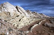
. The San Rafael Swell, approximately 75 miles (120.7 km) by 40 miles (64.4 km), consists of a giant dome-shaped anticline
of sandstone, shale, and limestone that was pushed up during the Paleocene Laramide Orogeny
60-40 million years ago. Since that time, infrequent but powerful flash floods have eroded the sedimentary rock
s into numerous valley
s, canyon
s, gorges, mesa
s and butte
s. The Swell is part of the Colorado Plateau
physiographic region
.
divides the Swell into northern and southern sections, and provides the only paved road access to the region. The swell lies entirely within Emery County
.
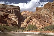
The northern Swell is drained mainly by the San Rafael River
, while the southern Swell is drained mainly by Muddy Creek
which eventually joins the Fremont River to become Dirty Devil River
northeast of Hanksville, Utah
. The Dirty Devil River flows southward into the Colorado River
, while the San Rafael River joins the Green River
before it also flows into the Colorado. Muddy Creek
cuts into the western edge of the Swell, exits at Muddy Creek Gorge, and then flows across the Blue Hills Badlands
near Caineville to its confluence with the Fremont River
.
dike swarm
rocks faulted
, or broke, during the Laramide orogeny
, about 60 million years ago. These "basement" rocks below the present-day Swell moved upwards relative to the surrounding areas and caused the overlying sedimentary rocks to fold
into a dome-like shape called an anticline
. The resulting structure is analogous to a series of blankets draped over a box.
Since that time, the relentless force of running water has eroded the geologic layers
, resulting in older rocks becoming exposed in the middle of the Swell, and younger rocks exposed around the edges. Many of the most impressive landforms are composed of more resistant rocks, including the Jurassic
Navajo Sandstone
, Triassic
Wingate Sandstone
, and Permian
Coconino Sandstone
. The folding is much steeper on the eastern edge of the Swell than in the west, and this eastern edge is referred to as the San Rafael Reef
.
Both the San Rafael River and Muddy Creek drain out of the high Wasatch Plateau and the cut directly across the uplift of the Reef, which marks them as "superimposed streams", pre-dating the time of the uplift.
Part of the Swell has geographic features that resembles Mars
. The Mars Society
decided to set up the Mars Desert Research Station
in the area as a Mars analog for such reasons.
(Pediocactus despainii).
cultures, including the Fremont, Paiute
, and Ute
, is common throughout the San Rafael Swell in the form of pictograph and petroglyph
panels. From about 1776 to the mid-1850s the Old Spanish Trail
trade route passed through (or just north of) the Swell. In the past 150 years, areas of the Swell have been used for the grazing
of sheep
and cattle
, as well as for uranium
mining
. Although surrounded by the communities of Price
, Green River
, Hanksville
, Ferron
, Castle Dale
, and Huntington
, the Swell itself does not support permanent residents.
Bureau of Land Management
, although the Swell as a whole does not currently enjoy special protection, parts of it are protected as wilderness study areas. Cattle grazing is only allowed in parts of The Swell that are not designated as such. The San Rafael Swell is also dotted with squares of land managed by The Utah School and Institutional Trust Lands Administration, as is much of the state of Utah. Goblin Valley State Park
is on the southeastern edge of the San Rafael Swell.
In 2002, then-governor Mike Leavitt of Utah proposed the creation of a San Rafael Swell National Monument
. President
George Bush
, who had authority to create such a monument under the Antiquities Act
, never acted on Leavitt's proposal. The idea of federal designation of the San Rafael Swell as a National Monument resurfaced in 2010 in a Department of the Interior
document.
.png)
, backpackers
, horseback riders, and all-terrain vehicle
(ATV) enthusiasts. Many steep, narrow slot canyons popular with technical canyoneers are found in the San Rafael Reef. The use of ATVs in the Swell is controversial, as environmentalists
are of the opinion that off-road vehicles damage the fragile desert cryptobiotic soil
s.
Geology
Geology is the science comprising the study of solid Earth, the rocks of which it is composed, and the processes by which it evolves. Geology gives insight into the history of the Earth, as it provides the primary evidence for plate tectonics, the evolutionary history of life, and past climates...
feature located in south-central Utah
Utah
Utah is a state in the Western United States. It was the 45th state to join the Union, on January 4, 1896. Approximately 80% of Utah's 2,763,885 people live along the Wasatch Front, centering on Salt Lake City. This leaves vast expanses of the state nearly uninhabited, making the population the...
, USA
United States
The United States of America is a federal constitutional republic comprising fifty states and a federal district...
about 30 miles (50 km) west of Green River, Utah
Green River, Utah
Green River is a city in Emery County, Utah, United States. The population was 973 at the 2000 census.-Geography:Green River is located at , on the banks of the Green River, after which the city is named. The San Rafael Swell region is to the west of Green River, while Canyonlands National Park...
. The San Rafael Swell, approximately 75 miles (120.7 km) by 40 miles (64.4 km), consists of a giant dome-shaped anticline
Anticline
In structural geology, an anticline is a fold that is convex up and has its oldest beds at its core. The term is not to be confused with antiform, which is a purely descriptive term for any fold that is convex up. Therefore if age relationships In structural geology, an anticline is a fold that is...
of sandstone, shale, and limestone that was pushed up during the Paleocene Laramide Orogeny
Laramide orogeny
The Laramide orogeny was a period of mountain building in western North America, which started in the Late Cretaceous, 70 to 80 million years ago, and ended 35 to 55 million years ago. The exact duration and ages of beginning and end of the orogeny are in dispute, as is the cause. The Laramide...
60-40 million years ago. Since that time, infrequent but powerful flash floods have eroded the sedimentary rock
Sedimentary rock
Sedimentary rock are types of rock that are formed by the deposition of material at the Earth's surface and within bodies of water. Sedimentation is the collective name for processes that cause mineral and/or organic particles to settle and accumulate or minerals to precipitate from a solution....
s into numerous valley
Valley
In geology, a valley or dale is a depression with predominant extent in one direction. A very deep river valley may be called a canyon or gorge.The terms U-shaped and V-shaped are descriptive terms of geography to characterize the form of valleys...
s, canyon
Canyon
A canyon or gorge is a deep ravine between cliffs often carved from the landscape by a river. Rivers have a natural tendency to reach a baseline elevation, which is the same elevation as the body of water it will eventually drain into. This forms a canyon. Most canyons were formed by a process of...
s, gorges, mesa
Mesa
A mesa or table mountain is an elevated area of land with a flat top and sides that are usually steep cliffs. It takes its name from its characteristic table-top shape....
s and butte
Butte
A butte is a conspicuous isolated hill with steep, often vertical sides and a small, relatively flat top; it is smaller than mesas, plateaus, and table landform tables. In some regions, such as the north central and northwestern United States, the word is used for any hill...
s. The Swell is part of the Colorado Plateau
Colorado Plateau
The Colorado Plateau, also called the Colorado Plateau Province, is a physiographic region of the Intermontane Plateaus, roughly centered on the Four Corners region of the southwestern United States. The province covers an area of 337,000 km2 within western Colorado, northwestern New Mexico,...
physiographic region
United States physiographic region
The list of continental United States Physiographic regions identifies the 8 regions, 25 provinces, and 85 sections. The system dates to Nevin Fenneman's paper Physiographic Subdivision of the United States, published in 1917...
.
Geography
Interstate 70Interstate 70
Interstate 70 is an Interstate Highway in the United States that runs from Interstate 15 near Cove Fort, Utah, to a Park and Ride near Baltimore, Maryland. It was the first Interstate Highway project in the United States. I-70 approximately traces the path of U.S. Route 40 east of the Rocky...
divides the Swell into northern and southern sections, and provides the only paved road access to the region. The swell lies entirely within Emery County
Emery County, Utah
Emery County is a county located in the U.S. state of Utah. As of 2000 the population was 10,860, and by 2009 had been estimated to decrease to 10,629. It was named for George W. Emery, governor of the Utah Territory in 1875...
.
The northern Swell is drained mainly by the San Rafael River
San Rafael River (Utah)
The San Rafael River is a tributary of the Green River, approximately long, in east central Utah in the United States. The river flows across a sparsely populated arid region of the Colorado Plateau, and is known for the isolated, scenic gorge through which it flows.It rises in northwestern...
, while the southern Swell is drained mainly by Muddy Creek
Muddy Creek
Muddy Creek may refer to:*Muddy Creek , a tributary of the Colorado River*Muddy Creek *Muddy Creek *Muddy Creek , a list of Muddy Creeks in the state*In Pennsylvania...
which eventually joins the Fremont River to become Dirty Devil River
Dirty Devil River
The Dirty Devil River is a long tributary of the Colorado River, located in the U.S. state of Utah. It flows through southern Utah from the confluence of Fremont River and Muddy Creek to the Colorado River.-Course:...
northeast of Hanksville, Utah
Hanksville, Utah
Hanksville is a small town in Wayne County, Utah, United States, at the junction of State Routes 24 and 95. The town is just south of the confluence of the Fremont River and Muddy Creek, which together form the Dirty Devil River, which then flows southeast to the Colorado River...
. The Dirty Devil River flows southward into the Colorado River
Colorado River
The Colorado River , is a river in the Southwestern United States and northwestern Mexico, approximately long, draining a part of the arid regions on the western slope of the Rocky Mountains. The watershed of the Colorado River covers in parts of seven U.S. states and two Mexican states...
, while the San Rafael River joins the Green River
Green River (Utah)
The Green River, located in the western United States, is the chief tributary of the Colorado River. The watershed of the river, known as the Green River Basin, covers parts of Wyoming, Utah, and Colorado. The Green River is long, beginning in the Wind River Mountains of Wyoming and flowing...
before it also flows into the Colorado. Muddy Creek
Muddy Creek (Utah)
Muddy Creek is a stream which drains portions of Emery and Wayne Counties in central Utah, in the western United States. It begins on the eastern slopes of the Wasatch Plateau at elevations above 10,500 feet . It turns southward near the town of Emery, then southeastward where it crosses under...
cuts into the western edge of the Swell, exits at Muddy Creek Gorge, and then flows across the Blue Hills Badlands
Badlands
A badlands is a type of dry terrain where softer sedimentary rocks and clay-rich soils have been extensively eroded by wind and water. It can resemble malpaís, a terrain of volcanic rock. Canyons, ravines, gullies, hoodoos and other such geological forms are common in badlands. They are often...
near Caineville to its confluence with the Fremont River
Fremont River (Utah)
The Fremont River in Utah flows from the Johnson Valley Reservoir, which is located on the Wasatch Plateau near Fish Lake, southwest through Capitol Reef National Park to the Muddy Creek near Hanksville where the two rivers combine to form the Dirty Devil River, a tributary of the Colorado River...
.
Geology
The San Rafael Swell was formed when deeply buried PrecambrianPrecambrian
The Precambrian is the name which describes the large span of time in Earth's history before the current Phanerozoic Eon, and is a Supereon divided into several eons of the geologic time scale...
dike swarm
Dike swarm
A dike swarm or dyke swarm is a large geological structure consisting of a major group of parallel, linear, or radially oriented dikes intruded within continental crust. They consist of several to hundreds of dikes emplaced more or less contemporaneously during a single intrusive event and are...
rocks faulted
Geologic fault
In geology, a fault is a planar fracture or discontinuity in a volume of rock, across which there has been significant displacement along the fractures as a result of earth movement. Large faults within the Earth's crust result from the action of tectonic forces...
, or broke, during the Laramide orogeny
Laramide orogeny
The Laramide orogeny was a period of mountain building in western North America, which started in the Late Cretaceous, 70 to 80 million years ago, and ended 35 to 55 million years ago. The exact duration and ages of beginning and end of the orogeny are in dispute, as is the cause. The Laramide...
, about 60 million years ago. These "basement" rocks below the present-day Swell moved upwards relative to the surrounding areas and caused the overlying sedimentary rocks to fold
Fold (geology)
The term fold is used in geology when one or a stack of originally flat and planar surfaces, such as sedimentary strata, are bent or curved as a result of permanent deformation. Synsedimentary folds are those due to slumping of sedimentary material before it is lithified. Folds in rocks vary in...
into a dome-like shape called an anticline
Anticline
In structural geology, an anticline is a fold that is convex up and has its oldest beds at its core. The term is not to be confused with antiform, which is a purely descriptive term for any fold that is convex up. Therefore if age relationships In structural geology, an anticline is a fold that is...
. The resulting structure is analogous to a series of blankets draped over a box.
Since that time, the relentless force of running water has eroded the geologic layers
Stratum
In geology and related fields, a stratum is a layer of sedimentary rock or soil with internally consistent characteristics that distinguish it from other layers...
, resulting in older rocks becoming exposed in the middle of the Swell, and younger rocks exposed around the edges. Many of the most impressive landforms are composed of more resistant rocks, including the Jurassic
Jurassic
The Jurassic is a geologic period and system that extends from about Mya to Mya, that is, from the end of the Triassic to the beginning of the Cretaceous. The Jurassic constitutes the middle period of the Mesozoic era, also known as the age of reptiles. The start of the period is marked by...
Navajo Sandstone
Navajo Sandstone
Navajo Sandstone is a geologic formation in the Glen Canyon Group that is spread across the U.S. states of northern Arizona, northwest Colorado, and Utah; as part of the Colorado Plateau province of the United States...
, Triassic
Triassic
The Triassic is a geologic period and system that extends from about 250 to 200 Mya . As the first period of the Mesozoic Era, the Triassic follows the Permian and is followed by the Jurassic. Both the start and end of the Triassic are marked by major extinction events...
Wingate Sandstone
Wingate Sandstone
Wingate Sandstone is a geologic formation in the Glen Canyon Group that is spread across the Colorado Plateau province of the United States, including northern Arizona, northwest Colorado, Nevada, and Utah. This rock formation is particularly prominent in southeastern Utah, where it forms...
, and Permian
Permian
The PermianThe term "Permian" was introduced into geology in 1841 by Sir Sir R. I. Murchison, president of the Geological Society of London, who identified typical strata in extensive Russian explorations undertaken with Edouard de Verneuil; Murchison asserted in 1841 that he named his "Permian...
Coconino Sandstone
Coconino Sandstone
Coconino Sandstone is a geologic formation named after its exposure in Coconino County, Arizona. This formation spreads across the Colorado Plateau province of the United States, including northern Arizona, northwest Colorado, Nevada, and Utah....
. The folding is much steeper on the eastern edge of the Swell than in the west, and this eastern edge is referred to as the San Rafael Reef
San Rafael Reef
The San Rafael Reef is a geologic feature located in Emery County in central Utah, part of the Colorado Plateau. Approximately 75 miles long, it is the name given to the distinctive eastern edge of the San Rafael Swell...
.
Both the San Rafael River and Muddy Creek drain out of the high Wasatch Plateau and the cut directly across the uplift of the Reef, which marks them as "superimposed streams", pre-dating the time of the uplift.
Part of the Swell has geographic features that resembles Mars
Mars
Mars is the fourth planet from the Sun in the Solar System. The planet is named after the Roman god of war, Mars. It is often described as the "Red Planet", as the iron oxide prevalent on its surface gives it a reddish appearance...
. The Mars Society
Mars Society
The Mars Society is an international space advocacy non-profit organization dedicated to promoting the human exploration and settlement of the planet Mars. It was founded by Robert Zubrin and others in 1998 and attracted the support of notable science fiction writers and filmmakers, including Kim...
decided to set up the Mars Desert Research Station
Mars Desert Research Station
The Mars Desert Research Station is the second of four planned simulated Mars surface exploration habitats owned and operated by the Mars Society.-Background:...
in the area as a Mars analog for such reasons.
Ecology
The San Rafael Swell is an area of high plant endemism, with many native plants occurring nowhere else in the world. An example is the endangered San Rafael cactusPediocactus despainii
Pediocactus despainii is a rare species of cactus known by the common names Despain's pincushion cactus, Despain footcactus, and San Rafael cactus. It is endemic to the state of Utah in the United States, where it is limited to the San Rafael Swell in Emery County. There are two populations...
(Pediocactus despainii).
History
Evidence of Native AmericanNative Americans in the United States
Native Americans in the United States are the indigenous peoples in North America within the boundaries of the present-day continental United States, parts of Alaska, and the island state of Hawaii. They are composed of numerous, distinct tribes, states, and ethnic groups, many of which survive as...
cultures, including the Fremont, Paiute
Paiute
Paiute refers to three closely related groups of Native Americans — the Northern Paiute of California, Idaho, Nevada and Oregon; the Owens Valley Paiute of California and Nevada; and the Southern Paiute of Arizona, southeastern California and Nevada, and Utah.-Origin of name:The origin of...
, and Ute
Ute Tribe
The Ute are an American Indian people now living primarily in Utah and Colorado. There are three Ute tribal reservations: Uintah-Ouray in northeastern Utah ; Southern Ute in Colorado ; and Ute Mountain which primarily lies in Colorado, but extends to Utah and New Mexico . The name of the state of...
, is common throughout the San Rafael Swell in the form of pictograph and petroglyph
Petroglyph
Petroglyphs are pictogram and logogram images created by removing part of a rock surface by incising, picking, carving, and abrading. Outside North America, scholars often use terms such as "carving", "engraving", or other descriptions of the technique to refer to such images...
panels. From about 1776 to the mid-1850s the Old Spanish Trail
Old Spanish Trail (trade route)
The Old Spanish Trail is a historical trade route which connected the northern New Mexico settlements near or in Santa Fe, New Mexico with that of Los Angeles, California and southern California. Approximately long, it ran through areas of high mountains, arid deserts, and deep canyons. It is...
trade route passed through (or just north of) the Swell. In the past 150 years, areas of the Swell have been used for the grazing
Grazing
Grazing generally describes a type of feeding, in which a herbivore feeds on plants , and also on other multicellular autotrophs...
of sheep
Domestic sheep
Sheep are quadrupedal, ruminant mammals typically kept as livestock. Like all ruminants, sheep are members of the order Artiodactyla, the even-toed ungulates. Although the name "sheep" applies to many species in the genus Ovis, in everyday usage it almost always refers to Ovis aries...
and cattle
Cattle
Cattle are the most common type of large domesticated ungulates. They are a prominent modern member of the subfamily Bovinae, are the most widespread species of the genus Bos, and are most commonly classified collectively as Bos primigenius...
, as well as for uranium
Uranium
Uranium is a silvery-white metallic chemical element in the actinide series of the periodic table, with atomic number 92. It is assigned the chemical symbol U. A uranium atom has 92 protons and 92 electrons, of which 6 are valence electrons...
mining
Mining
Mining is the extraction of valuable minerals or other geological materials from the earth, from an ore body, vein or seam. The term also includes the removal of soil. Materials recovered by mining include base metals, precious metals, iron, uranium, coal, diamonds, limestone, oil shale, rock...
. Although surrounded by the communities of Price
Price, Utah
Price is a city in Carbon County, Utah, United States. The city is home to the USU-College of Eastern Utah, as well as the large USU Eastern Prehistoric Museum affiliated with the college. Price is located within short distances from both Nine Mile Canyon and the Manti-La Sal National Forest...
, Green River
Green River, Utah
Green River is a city in Emery County, Utah, United States. The population was 973 at the 2000 census.-Geography:Green River is located at , on the banks of the Green River, after which the city is named. The San Rafael Swell region is to the west of Green River, while Canyonlands National Park...
, Hanksville
Hanksville, Utah
Hanksville is a small town in Wayne County, Utah, United States, at the junction of State Routes 24 and 95. The town is just south of the confluence of the Fremont River and Muddy Creek, which together form the Dirty Devil River, which then flows southeast to the Colorado River...
, Ferron
Ferron, Utah
Ferron is a city in Emery County, Utah, United States. The population was 1,623 at the 2000 census.-Geography:Ferron is located at ....
, Castle Dale
Castle Dale, Utah
Castle Dale is a city in Emery County, Utah, United States. The population was 1,657 at the 2000 census. It is the county seat of Emery County.-History:...
, and Huntington
Huntington, Utah
Huntington is a town in Emery County, Utah, United States. The population was 2,131 at the 2000 census. It is the largest town in Emery County.-History:...
, the Swell itself does not support permanent residents.
Administration
The area is managed by the U.S.United States
The United States of America is a federal constitutional republic comprising fifty states and a federal district...
Bureau of Land Management
Bureau of Land Management
The Bureau of Land Management is an agency within the United States Department of the Interior which administers America's public lands, totaling approximately , or one-eighth of the landmass of the country. The BLM also manages of subsurface mineral estate underlying federal, state and private...
, although the Swell as a whole does not currently enjoy special protection, parts of it are protected as wilderness study areas. Cattle grazing is only allowed in parts of The Swell that are not designated as such. The San Rafael Swell is also dotted with squares of land managed by The Utah School and Institutional Trust Lands Administration, as is much of the state of Utah. Goblin Valley State Park
Goblin Valley State Park
Goblin Valley State Park is a state park of Utah, USA.Its eminent feature is its thousands of hoodoos and hoodoo rocks, which are formations of mushroom-shaped rock pinnacles, some as high as several meters...
is on the southeastern edge of the San Rafael Swell.
In 2002, then-governor Mike Leavitt of Utah proposed the creation of a San Rafael Swell National Monument
U.S. National Monument
A National Monument in the United States is a protected area that is similar to a National Park except that the President of the United States can quickly declare an area of the United States to be a National Monument without the approval of Congress. National monuments receive less funding and...
. President
President of the United States
The President of the United States of America is the head of state and head of government of the United States. The president leads the executive branch of the federal government and is the commander-in-chief of the United States Armed Forces....
George Bush
George W. Bush
George Walker Bush is an American politician who served as the 43rd President of the United States, from 2001 to 2009. Before that, he was the 46th Governor of Texas, having served from 1995 to 2000....
, who had authority to create such a monument under the Antiquities Act
Antiquities Act
The Antiquities Act of 1906, officially An Act for the Preservation of American Antiquities , is an act passed by the United States Congress and signed into law by Theodore Roosevelt on June 8, 1906, giving the President of the United States authority to, by executive order, restrict the use of...
, never acted on Leavitt's proposal. The idea of federal designation of the San Rafael Swell as a National Monument resurfaced in 2010 in a Department of the Interior
United States Department of the Interior
The United States Department of the Interior is the United States federal executive department of the U.S. government responsible for the management and conservation of most federal land and natural resources, and the administration of programs relating to Native Americans, Alaska Natives, Native...
document.
Recreation
The San Rafael Swell attracts hikersHiking
Hiking is an outdoor activity which consists of walking in natural environments, often in mountainous or other scenic terrain. People often hike on hiking trails. It is such a popular activity that there are numerous hiking organizations worldwide. The health benefits of different types of hiking...
, backpackers
Backpacking (wilderness)
Backpacking combines the activities of hiking and camping for an overnight stay in backcountry wilderness...
, horseback riders, and all-terrain vehicle
All-terrain vehicle
An all-terrain vehicle , also known as a quad, quad bike, three wheeler, or four wheeler, is defined by the American National Standards Institute as a vehicle that travels on low pressure tires, with a seat that is straddled by the operator, along with handlebars for steering control...
(ATV) enthusiasts. Many steep, narrow slot canyons popular with technical canyoneers are found in the San Rafael Reef. The use of ATVs in the Swell is controversial, as environmentalists
Environmentalism
Environmentalism is a broad philosophy, ideology and social movement regarding concerns for environmental conservation and improvement of the health of the environment, particularly as the measure for this health seeks to incorporate the concerns of non-human elements...
are of the opinion that off-road vehicles damage the fragile desert cryptobiotic soil
Cryptobiotic soil
A Cryptobiotic soil is a biological soil crust composed of living cyanobacteria, green algae, brown algae, fungi, lichens, and/or mosses. Commonly found in arid regions around the world, cryptobiotic soils go by many names, including cryptogamic, microbiotic, or microphytic soils or crusts...
s.