
.gif)
Old Spanish Trail (trade route)
Encyclopedia
The Old Spanish Trail is a historical trade route
which connected the northern New Mexico
settlements near or in Santa Fe, New Mexico
with that of Los Angeles, California
and southern California. Approximately 1200 mi (1,931.2 km) long, it ran through areas of high mountains, arid deserts, and deep canyons. It is considered one of the most arduous of all trade routes ever established in the United States. Explored, in part, by Spanish explorers as early as the late 1500s, the Trail saw extensive use by pack trains from about 1830 until the mid-1850s.
The name of the trail comes from the publication of John C. Frémont
’s Report of his 1844 journey for the U.S. Topographical Corps. guided by Kit Carson
from California to New Mexico. The name acknowledges the fact that parts of the trail had been known to the Spanish since the sixteenth century. Frémont's report named a trail that had already been in use for about 15 years. The trail is significant to New Mexico history, because it established an arduous but usable trade route with California.
 The trail is combination of known trails that were established by Spanish explorers, trappers and traders with the Ute
and other tribes of Indians. The eastern areas of what became called the Old Spanish Trail, including southwest Colorado
and southeast Utah
, were explored by Juan Maria de Rivera
in 1765. Franciscan
missionaries Francisco Atanasio Domínguez and Silvestre Vélez de Escalante unsuccessfully attempted the trip to California
, which was just being settled, leaving Santa Fe in 1776 and making it all the way into the Great Basin
near Utah Lake
before returning via the Arizona Strip
. Other expeditions under another Franciscan missionary Francisco Garcés
, and Captain Juan Bautista de Anza
then explored and traded in the southern part of the region, finding shorter and less arduous routes through the mountains and deserts which connected Sonora to New Mexico and California, but did not become part of the Old Spanish Trail, with the exception of some of the paths through the Mojave Desert
. The middle part of the trail through Nevada and California was worked out by trappers led by Jedediah Smith
in about 1827.
A route linking New Mexico
to California
, combining information from many explorers, was opened in 1829-30 when Santa Fe
merchant Antonio Armijo
led a trade party of 60 men and 100 mules to California. Using a short cut discovered by Rafael Rivera the previous year, the Armijo party was able to stitch together a route that connected the routes of the Rivera and Domínguez-Escalante Expeditions and the Jedediah Smith explorations with the approaches to San Gabriel Mission
through the Mojave along the Mojave River
. After this date, the route began to be used by traders for usually a single annual round trip. Upon the return of Antonio Armijo, the governor of New Mexico
immediately announced the success to his superiors in Mexico City. As a reward, the governor officially named Armijo “Commander for the Discovery of the Route to California.”
Word spread about the successful trade expedition and some commerce began between Santa Fe and Los Angeles. This commerce usually consisted of one mule-laden pack train from Santa Fe with 20 to 200 members, with roughly twice as many mules, bringing New Mexico goods hand-woven by Indians, such as serapes and blankets, to California. California had many horses and mules, many growing wild, with no local market, which were readily traded for hand-woven Indian products. Usually two blankets were traded for one horse, more blankets were usually required for a mule. California had almost no wool processing industry and few weavers, so woven products were a welcome commodity. The trading party usually left New Mexico in early November to take advantage of winter rains to cross the deserts on the trail and would arrive in California in early February. The return party would usually leave California for New Mexico in early April to get over the trail before the water holes dried up and the melting snow raised the rivers too high. The return party often consisted of several hundred to a few thousand horses and mules. Low-scale emigration from New Mexico to California used parts of the trail in the late 1830s when the trapping trade began to die. The trail was also used for illicit purposes, namely to raid the California ranchos for horses and for an extensive Indian slave trade. These horse raids were made by Mexicans, ex-trappers and Indian tribes who together stole hundreds to thousands of horses in one raid. Native Americans, usually women and children, were captured and sold to Mexican ranchers, etc., in both California and New Mexico for domestic servants. Mexican traders and Indian raiding parties both participated in this slave trade. The consequences of this human trafficking had a long-standing effect for those who lived along the trail, even after the trail was no longer in use. Intermittent Indian warfare along the trail often resulted from these slave raids by unscrupulous traders and raiding Indians.
John C. Frémont
, "The Great Pathfinder," took the route, guided by Kit Carson
, in 1844 and named it in his reports written up in about 1848. New Mexico-California trade continued until the mid-1850s, when a shift to the use of freight wagon
s and the development of wagon trails made the old pack trail route obsolete. By 1846 both New Mexico and California had become U.S. territories as a result of the Mexican-American War of 1846-1848, and after 1848 large numbers of Mormon
immigrants were settling in Utah
, Nevada
and California
all along the trail, affecting both trade interests and tolerance for the slavery of American Natives.
Place names used in this article refer to present-day states and communities. Few (if any) settlements existed along the trail before 1850, although many of the geologic features along the Trail retain their Spanish designations.

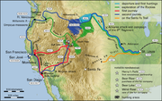
 The central route of the Old Spanish Trail, which had to swing north to avoid the impassable Grand
and Glen Canyon
s on the Colorado River
, ran northwest from Santa Fe through southwestern Colorado
, past the San Juan Mountains
, Mancos
, and Dove Creek
, entering Utah near present day Monticello, Utah
. The trail then proceeded north through difficult terrain to Spanish Valley near today's Moab, Utah
, where it crossed the difficult and wide Colorado River and then turned northwest to cross the treacherous Green River
near present day Green River, Utah
. The route then passed through (or around) the San Rafael Swell
, the northernmost reach of the Trail. Entering the Great Basin
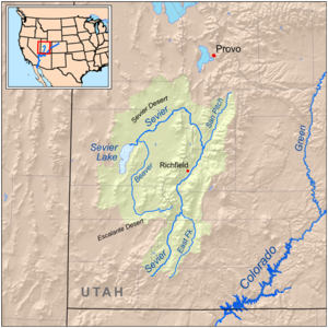
in Utah via Salina Canyon, the trail turned southwest following the Sevier River
, Santa Clara River
and Virgin River
before ascending the Mormon Plateau and hitting the Muddy River
in present-day Nevada. From there, it was a 55 miles (88.5 km) waterless trip crossing southern Nevada
to the springs at Las Vegas, Nevada
. From Las Vegas, the trail went across the Mojave desert from Mountain, Resting, Salt and Bitter springs (which were sometimes dry), each about a day's travel apart across the Mojave Desert
until it reached the only intermittently-dependable Mojave River
. The river was followed to a point near Cajon Pass
over the San Bernardino Mountains
. If parts of the Mojave River were dry, travelers could sometimes find water by digging in the old river bed. Descending Cajon Pass to reach the coastal plains, the trail turned west along the foot of the San Gabriel Mountains
to where the Mission San Gabriel Arcángel
and El Pueblo de Los Ángeles
in California were located. In all, the route involved several dry sections with limited grass and sometimes limited water, crossed two deserts, and was often littered with the bones of horses that had died of thirst. The route could only be used semi-reliably in winter when winter rains or snows deposited water in the desert. In summer, there was often no water and the oppressive heat could kill. A single round trip per year was about all that was feasible. Later parts of the trail were used for winter access to California when other trails were closed by snow. Alternate routes for this journey existed through central Colorado and through the Arizona Strip.
Although few traces of the early traders' trail remain, the Trail is now commemorated in many local street and road names, and numerous historical markers in the states that it crossed. It is listed as the Old Spanish National Historic Trail by the Bureau of Land Management
and National Park Service
. Portions of US 160 in Colorado and US 191 in Utah are similarly designated.
See Also: National Trail map of Old Spanish Trail
was placed on the National Register of Historic Places
.
In 2001, the section of the Trail that runs across Nevada from the Arizona border to California (known as the "Old Spanish Trail-Mormon Road Historic District") was placed on the National Register of Historic Places.
Trade route
A trade route is a logistical network identified as a series of pathways and stoppages used for the commercial transport of cargo. Allowing goods to reach distant markets, a single trade route contains long distance arteries which may further be connected to several smaller networks of commercial...
which connected the northern New Mexico
New Mexico
New Mexico is a state located in the southwest and western regions of the United States. New Mexico is also usually considered one of the Mountain States. With a population density of 16 per square mile, New Mexico is the sixth-most sparsely inhabited U.S...
settlements near or in Santa Fe, New Mexico
Santa Fe, New Mexico
Santa Fe is the capital of the U.S. state of New Mexico. It is the fourth-largest city in the state and is the seat of . Santa Fe had a population of 67,947 in the 2010 census...
with that of Los Angeles, California
Los Angeles, California
Los Angeles , with a population at the 2010 United States Census of 3,792,621, is the most populous city in California, USA and the second most populous in the United States, after New York City. It has an area of , and is located in Southern California...
and southern California. Approximately 1200 mi (1,931.2 km) long, it ran through areas of high mountains, arid deserts, and deep canyons. It is considered one of the most arduous of all trade routes ever established in the United States. Explored, in part, by Spanish explorers as early as the late 1500s, the Trail saw extensive use by pack trains from about 1830 until the mid-1850s.
The name of the trail comes from the publication of John C. Frémont
John C. Frémont
John Charles Frémont , was an American military officer, explorer, and the first candidate of the anti-slavery Republican Party for the office of President of the United States. During the 1840s, that era's penny press accorded Frémont the sobriquet The Pathfinder...
’s Report of his 1844 journey for the U.S. Topographical Corps. guided by Kit Carson
Kit Carson
Christopher Houston "Kit" Carson was an American frontiersman and Indian fighter. Carson left home in rural present-day Missouri at age 16 and became a Mountain man and trapper in the West. Carson explored the west to California, and north through the Rocky Mountains. He lived among and married...
from California to New Mexico. The name acknowledges the fact that parts of the trail had been known to the Spanish since the sixteenth century. Frémont's report named a trail that had already been in use for about 15 years. The trail is significant to New Mexico history, because it established an arduous but usable trade route with California.
History
Ute Tribe
The Ute are an American Indian people now living primarily in Utah and Colorado. There are three Ute tribal reservations: Uintah-Ouray in northeastern Utah ; Southern Ute in Colorado ; and Ute Mountain which primarily lies in Colorado, but extends to Utah and New Mexico . The name of the state of...
and other tribes of Indians. The eastern areas of what became called the Old Spanish Trail, including southwest Colorado
Colorado
Colorado is a U.S. state that encompasses much of the Rocky Mountains as well as the northeastern portion of the Colorado Plateau and the western edge of the Great Plains...
and southeast Utah
Utah
Utah is a state in the Western United States. It was the 45th state to join the Union, on January 4, 1896. Approximately 80% of Utah's 2,763,885 people live along the Wasatch Front, centering on Salt Lake City. This leaves vast expanses of the state nearly uninhabited, making the population the...
, were explored by Juan Maria de Rivera
Juan Rivera (explorer)
Juan Maria Antonio Rivera was an 18th century Spanish explorer who explored southwestern North America, including parts of Southern Rocky Mountains...
in 1765. Franciscan
Franciscan
Most Franciscans are members of Roman Catholic religious orders founded by Saint Francis of Assisi. Besides Roman Catholic communities, there are also Old Catholic, Anglican, Lutheran, ecumenical and Non-denominational Franciscan communities....
missionaries Francisco Atanasio Domínguez and Silvestre Vélez de Escalante unsuccessfully attempted the trip to California
Las Californias
The Californias, or in — - was the name given by the Spanish to their northwestern territory of New Spain, comprising the present day states of Baja California and Baja California Sur on the Baja California Peninsula in Mexico; and the present day U.S. state of California in the United States of...
, which was just being settled, leaving Santa Fe in 1776 and making it all the way into the Great Basin
Great Basin
The Great Basin is the largest area of contiguous endorheic watersheds in North America and is noted for its arid conditions and Basin and Range topography that varies from the North American low point at Badwater Basin to the highest point of the contiguous United States, less than away at the...
near Utah Lake
Utah Lake
Utah Lake is a freshwater lake in the U.S. state of Utah. On the western side of Utah Valley, the lake is overlooked by Mount Timpanogos and Mount Nebo. The lake's only river outlet, the Jordan River, is a tributary of the Great Salt Lake and is highly regulated with pumps. Evaporation accounts...
before returning via the Arizona Strip
Arizona Strip
The Arizona Strip is the part of the U.S. state of Arizona lying north of the Colorado River. The difficulty of crossing the Grand Canyon causes this region to have more natural connections with southern Utah and Nevada than with the rest of Arizona....
. Other expeditions under another Franciscan missionary Francisco Garcés
Francisco Garcés
Francisco Hermenegildo Tomás Garcés was a Spanish Franciscan missionary who explored much of the southwestern part of North America, including what are now Arizona, southern California, and northeastern Baja California. Garcés was born April 12, 1738, in Morata de Jalón , Zaragoza province,...
, and Captain Juan Bautista de Anza
Juan Bautista de Anza
Juan Bautista de Anza Bezerra Nieto was a Novo-Spanish explorer and Governor of New Mexico for the Spanish Empire.-Early life:...
then explored and traded in the southern part of the region, finding shorter and less arduous routes through the mountains and deserts which connected Sonora to New Mexico and California, but did not become part of the Old Spanish Trail, with the exception of some of the paths through the Mojave Desert
Mojave Desert
The Mojave Desert occupies a significant portion of southeastern California and smaller parts of central California, southern Nevada, southwestern Utah and northwestern Arizona, in the United States...
. The middle part of the trail through Nevada and California was worked out by trappers led by Jedediah Smith
Jedediah Smith
Jedediah Strong Smith was a hunter, trapper, fur trader, trailblazer, author, cartographer, cattleman, and explorer of the Rocky Mountains, the American West Coast and the Southwest during the 19th century...
in about 1827.
A route linking New Mexico
New Mexico
New Mexico is a state located in the southwest and western regions of the United States. New Mexico is also usually considered one of the Mountain States. With a population density of 16 per square mile, New Mexico is the sixth-most sparsely inhabited U.S...
to California
California
California is a state located on the West Coast of the United States. It is by far the most populous U.S. state, and the third-largest by land area...
, combining information from many explorers, was opened in 1829-30 when Santa Fe
Santa Fe, New Mexico
Santa Fe is the capital of the U.S. state of New Mexico. It is the fourth-largest city in the state and is the seat of . Santa Fe had a population of 67,947 in the 2010 census...
merchant Antonio Armijo
Antonio Armijo
Antonio Armijo was a Spanish Mexican explorer and merchant who was famous for leading the first commercial caravan party across the Las Vegas Valley in 1829. His route is known as the Old Spanish Trail...
led a trade party of 60 men and 100 mules to California. Using a short cut discovered by Rafael Rivera the previous year, the Armijo party was able to stitch together a route that connected the routes of the Rivera and Domínguez-Escalante Expeditions and the Jedediah Smith explorations with the approaches to San Gabriel Mission
Mission San Gabriel Arcángel
The Mission San Gabriel Arcángel is a fully functioning Roman Catholic mission and a historic landmark in San Gabriel, California. The settlement was founded by Spaniards of the Franciscan order on "The Feast of the Birth of Mary," September 8, 1771, as the fourth of what would become 21 Spanish...
through the Mojave along the Mojave River
Mojave River
The Mojave River is an intermittent river in the eastern San Bernardino Mountains and Mojave Desert in San Bernardino County, California. The river is notable as most of its flow is underground, while its surface channels remain dry most of the time, with the exception of the headwaters and several...
. After this date, the route began to be used by traders for usually a single annual round trip. Upon the return of Antonio Armijo, the governor of New Mexico
Manuel Armijo
Manuel Armijo was a New Mexican soldier and statesman who served three times as governor of New Mexico. He was instrumental in putting down the Revolt of 1837, he led the force that captured the Texan Santa Fe Expedition and he surrendered to the United States in the Mexican-American War.-Early...
immediately announced the success to his superiors in Mexico City. As a reward, the governor officially named Armijo “Commander for the Discovery of the Route to California.”
Word spread about the successful trade expedition and some commerce began between Santa Fe and Los Angeles. This commerce usually consisted of one mule-laden pack train from Santa Fe with 20 to 200 members, with roughly twice as many mules, bringing New Mexico goods hand-woven by Indians, such as serapes and blankets, to California. California had many horses and mules, many growing wild, with no local market, which were readily traded for hand-woven Indian products. Usually two blankets were traded for one horse, more blankets were usually required for a mule. California had almost no wool processing industry and few weavers, so woven products were a welcome commodity. The trading party usually left New Mexico in early November to take advantage of winter rains to cross the deserts on the trail and would arrive in California in early February. The return party would usually leave California for New Mexico in early April to get over the trail before the water holes dried up and the melting snow raised the rivers too high. The return party often consisted of several hundred to a few thousand horses and mules. Low-scale emigration from New Mexico to California used parts of the trail in the late 1830s when the trapping trade began to die. The trail was also used for illicit purposes, namely to raid the California ranchos for horses and for an extensive Indian slave trade. These horse raids were made by Mexicans, ex-trappers and Indian tribes who together stole hundreds to thousands of horses in one raid. Native Americans, usually women and children, were captured and sold to Mexican ranchers, etc., in both California and New Mexico for domestic servants. Mexican traders and Indian raiding parties both participated in this slave trade. The consequences of this human trafficking had a long-standing effect for those who lived along the trail, even after the trail was no longer in use. Intermittent Indian warfare along the trail often resulted from these slave raids by unscrupulous traders and raiding Indians.
John C. Frémont
John C. Frémont
John Charles Frémont , was an American military officer, explorer, and the first candidate of the anti-slavery Republican Party for the office of President of the United States. During the 1840s, that era's penny press accorded Frémont the sobriquet The Pathfinder...
, "The Great Pathfinder," took the route, guided by Kit Carson
Kit Carson
Christopher Houston "Kit" Carson was an American frontiersman and Indian fighter. Carson left home in rural present-day Missouri at age 16 and became a Mountain man and trapper in the West. Carson explored the west to California, and north through the Rocky Mountains. He lived among and married...
, in 1844 and named it in his reports written up in about 1848. New Mexico-California trade continued until the mid-1850s, when a shift to the use of freight wagon
Wagon
A wagon is a heavy four-wheeled vehicle pulled by draught animals; it was formerly often called a wain, and if low and sideless may be called a dray, trolley or float....
s and the development of wagon trails made the old pack trail route obsolete. By 1846 both New Mexico and California had become U.S. territories as a result of the Mexican-American War of 1846-1848, and after 1848 large numbers of Mormon
Mormon
The term Mormon most commonly denotes an adherent, practitioner, follower, or constituent of Mormonism, which is the largest branch of the Latter Day Saint movement in restorationist Christianity...
immigrants were settling in Utah
Utah
Utah is a state in the Western United States. It was the 45th state to join the Union, on January 4, 1896. Approximately 80% of Utah's 2,763,885 people live along the Wasatch Front, centering on Salt Lake City. This leaves vast expanses of the state nearly uninhabited, making the population the...
, Nevada
Nevada
Nevada is a state in the western, mountain west, and southwestern regions of the United States. With an area of and a population of about 2.7 million, it is the 7th-largest and 35th-most populous state. Over two-thirds of Nevada's people live in the Las Vegas metropolitan area, which contains its...
and California
California
California is a state located on the West Coast of the United States. It is by far the most populous U.S. state, and the third-largest by land area...
all along the trail, affecting both trade interests and tolerance for the slavery of American Natives.
Place names used in this article refer to present-day states and communities. Few (if any) settlements existed along the trail before 1850, although many of the geologic features along the Trail retain their Spanish designations.
Description of Trail Route
Grand Canyon
The Grand Canyon is a steep-sided canyon carved by the Colorado River in the United States in the state of Arizona. It is largely contained within the Grand Canyon National Park, the 15th national park in the United States...
and Glen Canyon
Glen Canyon
Glen Canyon is a canyon that is located in southeastern and south central Utah and northwestern Arizona within the Vermilion Cliffs area. It was carved by the Colorado River....
s on the Colorado River
Colorado River
The Colorado River , is a river in the Southwestern United States and northwestern Mexico, approximately long, draining a part of the arid regions on the western slope of the Rocky Mountains. The watershed of the Colorado River covers in parts of seven U.S. states and two Mexican states...
, ran northwest from Santa Fe through southwestern Colorado
Colorado
Colorado is a U.S. state that encompasses much of the Rocky Mountains as well as the northeastern portion of the Colorado Plateau and the western edge of the Great Plains...
, past the San Juan Mountains
San Juan Mountains
The San Juan Mountains are a high and rugged mountain range in the Rocky Mountains in southwestern Colorado. The area is highly mineralized and figured in the gold and silver mining industry of early Colorado. Major towns, all old mining camps, include Creede, Lake City, Silverton, Ouray, and...
, Mancos
Mancos, Colorado
The town of Mancos is a Statutory Town located in Montezuma County, Colorado, United States. The population was 1,119 at the 2000 census.The town of Mancos is located in southwestern Colorado, near the Four Corners, at the base of Mesa Verde National Park, and holds the trademark for "Gateway to...
, and Dove Creek
Dove Creek, Colorado
The Town of Dove Creek is a Statutory Town that is the county seat and the most populous town of Dolores County, Colorado, United States. Dove Creek is the self-proclaimed Pinto Bean Capital of the World...
, entering Utah near present day Monticello, Utah
Monticello, Utah
Monticello is a city located in San Juan County, Utah, and is the county seat. It is the second most populous city in San Juan County, with a population of 1,958 at the 2000 census. The Monticello area was settled in July 1887 by pioneers from The Church of Jesus Christ of Latter-day Saints...
. The trail then proceeded north through difficult terrain to Spanish Valley near today's Moab, Utah
Moab, Utah
Moab is a city in Grand County, in eastern Utah, in the western United States. The population was 4,779 at the 2000 census. It is the county seat and largest city in Grand County. Moab hosts a large number of tourists every year, mostly visitors to the nearby Arches and Canyonlands National Parks...
, where it crossed the difficult and wide Colorado River and then turned northwest to cross the treacherous Green River
Green River, Utah
Green River is a city in Emery County, Utah, United States. The population was 973 at the 2000 census.-Geography:Green River is located at , on the banks of the Green River, after which the city is named. The San Rafael Swell region is to the west of Green River, while Canyonlands National Park...
near present day Green River, Utah
Green River, Utah
Green River is a city in Emery County, Utah, United States. The population was 973 at the 2000 census.-Geography:Green River is located at , on the banks of the Green River, after which the city is named. The San Rafael Swell region is to the west of Green River, while Canyonlands National Park...
. The route then passed through (or around) the San Rafael Swell
San Rafael Swell
The San Rafael Swell is a large geologic feature located in south-central Utah, USA about 30 miles west of Green River, Utah. The San Rafael Swell, approximately by , consists of a giant dome-shaped anticline of sandstone, shale, and limestone that was pushed up during the Paleocene Laramide...
, the northernmost reach of the Trail. Entering the Great Basin
Great Basin
The Great Basin is the largest area of contiguous endorheic watersheds in North America and is noted for its arid conditions and Basin and Range topography that varies from the North American low point at Badwater Basin to the highest point of the contiguous United States, less than away at the...
in Utah via Salina Canyon, the trail turned southwest following the Sevier River
Sevier River
The Sevier River , extending , is the longest Utah river entirely in the state and drains an extended chain of mountain farming valleys to the intermittent Sevier Lake...
, Santa Clara River
Santa Clara River (Utah)
The Santa Clara River is a river whose three forks join above Pine Valley in the Pine Valley Mountains in Washington County, Utah, United States. It flows west, then south, then briefly southeast before joining the Virgin River just south of St. George...
and Virgin River
Virgin River
The Virgin River is a tributary of the Colorado River in the U.S. states of Utah, Nevada, and Arizona. The river is about long. It was designated Utah's first wild and scenic river in 2009, during the centennial celebration of Zion National Park.-Course:...
before ascending the Mormon Plateau and hitting the Muddy River
Muddy River
The Muddy River, formerly known as the Moapa River, is a short river located in the southern part of the state in Clark County, Nevada, United States. It is in the Mojave Desert, approximately 60 miles north of Las Vegas.-Geography:...
in present-day Nevada. From there, it was a 55 miles (88.5 km) waterless trip crossing southern Nevada
Nevada
Nevada is a state in the western, mountain west, and southwestern regions of the United States. With an area of and a population of about 2.7 million, it is the 7th-largest and 35th-most populous state. Over two-thirds of Nevada's people live in the Las Vegas metropolitan area, which contains its...
to the springs at Las Vegas, Nevada
Las Vegas, Nevada
Las Vegas is the most populous city in the U.S. state of Nevada and is also the county seat of Clark County, Nevada. Las Vegas is an internationally renowned major resort city for gambling, shopping, and fine dining. The city bills itself as The Entertainment Capital of the World, and is famous...
. From Las Vegas, the trail went across the Mojave desert from Mountain, Resting, Salt and Bitter springs (which were sometimes dry), each about a day's travel apart across the Mojave Desert
Mojave Desert
The Mojave Desert occupies a significant portion of southeastern California and smaller parts of central California, southern Nevada, southwestern Utah and northwestern Arizona, in the United States...
until it reached the only intermittently-dependable Mojave River
Mojave River
The Mojave River is an intermittent river in the eastern San Bernardino Mountains and Mojave Desert in San Bernardino County, California. The river is notable as most of its flow is underground, while its surface channels remain dry most of the time, with the exception of the headwaters and several...
. The river was followed to a point near Cajon Pass
Cajon Pass
Cajon Pass is a moderate-elevation mountain pass between the San Bernardino Mountains and the San Gabriel Mountains in Southern California in the United States. It was created by the movements of the San Andreas Fault...
over the San Bernardino Mountains
San Bernardino Mountains
The San Bernardino Mountains are a short transverse mountain range north and east of San Bernardino in Southern California in the United States. The mountains run for approximately 60 miles east-west on the southern edge of the Mojave Desert in southwestern San Bernardino County, north of the...
. If parts of the Mojave River were dry, travelers could sometimes find water by digging in the old river bed. Descending Cajon Pass to reach the coastal plains, the trail turned west along the foot of the San Gabriel Mountains
San Gabriel Mountains
The San Gabriel Mountains Range is located in northern Los Angeles County and western San Bernardino County, California, United States. The mountain range lies between the Los Angeles Basin and the Mojave Desert, with Interstate 5 to the west and Interstate 15 to the east...
to where the Mission San Gabriel Arcángel
Mission San Gabriel Arcángel
The Mission San Gabriel Arcángel is a fully functioning Roman Catholic mission and a historic landmark in San Gabriel, California. The settlement was founded by Spaniards of the Franciscan order on "The Feast of the Birth of Mary," September 8, 1771, as the fourth of what would become 21 Spanish...
and El Pueblo de Los Ángeles
History of Los Angeles, California
Los Angeles changed rapidly after 1848, when California was transferred to the United States as a result of the Treaty of Guadalupe Hidalgo that ended the Mexican-American War...
in California were located. In all, the route involved several dry sections with limited grass and sometimes limited water, crossed two deserts, and was often littered with the bones of horses that had died of thirst. The route could only be used semi-reliably in winter when winter rains or snows deposited water in the desert. In summer, there was often no water and the oppressive heat could kill. A single round trip per year was about all that was feasible. Later parts of the trail were used for winter access to California when other trails were closed by snow. Alternate routes for this journey existed through central Colorado and through the Arizona Strip.
Although few traces of the early traders' trail remain, the Trail is now commemorated in many local street and road names, and numerous historical markers in the states that it crossed. It is listed as the Old Spanish National Historic Trail by the Bureau of Land Management
Bureau of Land Management
The Bureau of Land Management is an agency within the United States Department of the Interior which administers America's public lands, totaling approximately , or one-eighth of the landmass of the country. The BLM also manages of subsurface mineral estate underlying federal, state and private...
and National Park Service
National Park Service
The National Park Service is the U.S. federal agency that manages all national parks, many national monuments, and other conservation and historical properties with various title designations...
. Portions of US 160 in Colorado and US 191 in Utah are similarly designated.
See Also: National Trail map of Old Spanish Trail
National Register of Historic Places listings
In 1988, a section of the trail in Arches National ParkArches National Park
Arches National Park is a U.S. National Park in eastern Utah. It is known for preserving over 2000 natural sandstone arches, including the world-famous Delicate Arch, in addition to a variety of unique geological resources and formations....
was placed on the National Register of Historic Places
National Register of Historic Places
The National Register of Historic Places is the United States government's official list of districts, sites, buildings, structures, and objects deemed worthy of preservation...
.
In 2001, the section of the Trail that runs across Nevada from the Arizona border to California (known as the "Old Spanish Trail-Mormon Road Historic District") was placed on the National Register of Historic Places.