
Crystal Geyser
Encyclopedia

Green River (Utah)
The Green River, located in the western United States, is the chief tributary of the Colorado River. The watershed of the river, known as the Green River Basin, covers parts of Wyoming, Utah, and Colorado. The Green River is long, beginning in the Wind River Mountains of Wyoming and flowing...
approximately 4.5 miles (7.25 km) downstream from Green River, Utah
Green River, Utah
Green River is a city in Emery County, Utah, United States. The population was 973 at the 2000 census.-Geography:Green River is located at , on the banks of the Green River, after which the city is named. The San Rafael Swell region is to the west of Green River, while Canyonlands National Park...
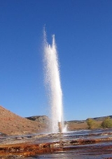
. It is a rare example of a cold water carbon dioxide driven geyser
Geyser
A geyser is a spring characterized by intermittent discharge of water ejected turbulently and accompanied by a vapour phase . The word geyser comes from Geysir, the name of an erupting spring at Haukadalur, Iceland; that name, in turn, comes from the Icelandic verb geysa, "to gush", the verb...
; geothermal activity does not play a role in the activity of the geyser. The ground water near the geyser has significant quantities of dissolved carbon dioxide, along with substantial underground gas accumulations in the surrounding area. Saturation of the aquifer with creates enough pressure to force groundwater through the geyser and out on to the surface.
The geyser erupts sometimes to a height of 40 meters or more. During 2005, a study of the timing of the eruptions found them to be bimodal. About 66% of eruptions in the study occurred about 8 hours after the previous eruption, and the rest about 22 hours after. The geyser erupts for an average of one hundred minutes a day, with eruptions either lasting 7–32 minutes, or 98–113 minutes. The bimodal distribution of eruptions is not a well-understood pattern, but is found in other geysers, both cold-water and otherwise.
Between eruption events, the water level is approximately seventeen feet below the surface of the geyser—at the level of the water table. In the preface to an eruption, water surfaces, fills the pond around the geyser, and begins to bubble. Bubbling events occur with increasing frequency in the time leading up to an eruption, but are not constant; bubbling events last for a few minutes, with a few minutes of calm in between. Bubbling events at the main geyser also frequently alternate with bubbling events at natural side-pools.
The current form of the geyser was created by an exploration well
Well drilling
Well drilling is the process of drilling a hole in the ground for the extraction of a natural resource such as ground water, natural gas, or petroleum...
drilled in 1935 in attempt to locate oil. The well was originally 800 metres deep, but an earlier owner of the land partially filled it in, meaning that the well is now only a couple hundred metres deep.
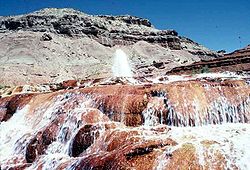
The area surrounding the modern geyser is covered in a thick layer of orange travertine
Travertine
Travertine is a form of limestone deposited by mineral springs, especially hot springs. Travertine often has a fibrous or concentric appearance and exists in white, tan, and cream-colored varieties. It is formed by a process of rapid precipitation of calcium carbonate, often at the mouth of a hot...
. Near the river, adjacent to the modern orange travertine, are substantial deposits of white travertine, perhaps reflecting the original depositional environment of the geyser (before the exploratory well was drilled.)
The first written record of Crystal Geyser comes from the report of the Powell Geographic Expedition of 1869
Powell Geographic Expedition of 1869
The Powell Geographic Expedition was a groundbreaking 19th century U.S. exploratory expedition of the American West, led by John Wesley Powell in 1869, that provided the first-ever thorough investigation of the Green and Colorado rivers, including the first known passage through the Grand Canyon...
, July 13, 1869:
We stop to examine some interesting rocks, deposited by mineral springs that at one time must have existed here, but which are no longer flowing.
See also
- List of geysers
- Soda Springs, IdahoSoda Springs, IdahoSoda Springs is a city in Caribou County, Idaho, United States. The population was 3,381 at the 2000 census. The city is the county seat of Caribou County....
- TravertineTravertineTravertine is a form of limestone deposited by mineral springs, especially hot springs. Travertine often has a fibrous or concentric appearance and exists in white, tan, and cream-colored varieties. It is formed by a process of rapid precipitation of calcium carbonate, often at the mouth of a hot...