
Canyonlands National Park
Encyclopedia
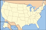
Canyonlands National Park is a U.S. National Park
located in southeastern Utah
near the town of Moab
and preserves a colorful landscape eroded into countless canyons, mesas and buttes by the Colorado River, the Green River, and their respective tributaries. The park is divided into four districts: the Island in the Sky, the Needles, the Maze, and the rivers themselves. While these areas share a primitive desert atmosphere, each retains its own character. The park covers 527.5 mi2. Canyons are carved into the Colorado Plateau
by the Colorado River and Green River
. Author Edward Abbey
, a frequent visitor, described the Canyonlands as "the most weird, wonderful, magical place on earth—there is nothing else like it anywhere."
, mountain bikers
, backpackers
, and four-wheelers
all enjoy traveling the rugged, remote trails within the Park. Rafters
and kayakers
float the calm stretches of the Green River
and Colorado River
above the confluence. Below the confluence Cataract Canyon
contains powerful whitewater rapids, similar to those found in the Grand Canyon
.
The Island in the Sky district, with its proximity to the Moab, Utah
area, attracts the majority (59 percent) of park users. The Needles district is the second most visited, drawing 35 percent of visitors. The rivers within the park and the remote Maze district each only account for 3 percent of park visitation.
Political compromise at the time of the park's creation limited the protected area to an arbitrary portion of the Canyonlands basin. Conservationists hope to complete the park by bringing the boundaries up to the high sandstone rims that form the natural border of the Canyonlands landscape.
and Green River
combine within the park, dividing it into three distinct districts. Below the confluence, the Colorado River flows through Cataract Canyon
.
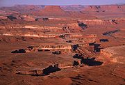 The Island in the Sky district is a broad and level mesa
to the north of the park between Colorado and Green
river with many overlooks from the White Rim, a sandstone bench 1200 feet (365.8 m) below the Island, and the rivers, which are another 1000 feet (304.8 m) below the White Rim.
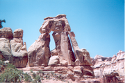
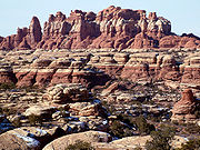
The Needles district is located east of the Colorado River and is named after the red and white banded rock pinnacles which dominate it, but various other forms of naturally sculptured rock such as canyons, graben
s, potholes, and a number of arches similar to the ones of the nearby Arches National Park
can be found as well. Unlike Arches National Park, where many arches are accessible by short to moderate hikes or even by car, most of the arches in the Needles district lie in back country canyons and require long hikes or four-wheel-drive trips to reach them.
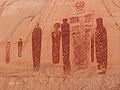
The area was once home of the Ancestral Puebloans, of which many traces can be found. Although the items and tools they used have been largely taken away by looters, some of their stone and mud dwellings are well-preserved. The Ancestral Puebloans also left traces in the form of petroglyph
s, most notably on the so-called Newspaper Rock
near the Visitor Center at the entrance of this district.
The Maze district is located west of the Colorado and Green rivers is the least accessible section of the park, and one of the most remote and inaccessible areas of the United States.
A geographically detached section of the park located west-northwest of the main unit, Horseshoe Canyon
Unit, contains panels of rock art made by hunter-gatherers from the Late Archaic Period (2000-1000 BC) pre-dating the Ancestral Puebloans. Originally called Barrier Canyon, Horseshoe's artifacts, dwellings, pictographs, and murals are some of the oldest in America. It is believed that the images depicting horses date from after 1540 AD, after the Spanish re-introduced horses to America.
 The National Weather Service
has maintained two cooperative weather stations in the park since June 1965. Official data documents the desert climate with less than 10 inches of annual rainfall, as well as very warm, mostly dry summers and cold, occasionally wet winters. Snowfall is generally light during the winter.
The station in The Neck region reports average January temperatures ranging from a high of 37 °F (2.8 °C) to a low of 20.7 °F (-6.3 °C). Average July temperatures range from a high of 90.7 °F (32.6 °C) to a low of 65.8 °F (18.8 °C). There are an average of 43.3 days with highs of 90 °F (32.2 °C) or higher and an average of 124.3 days with lows of 32 °F (0 °C) or lower. The highest recorded temperature was 105 °F (40.6 °C) on July 15, 2005, and the lowest recorded temperature was -13 F on February 6, 1989. Average annual precipitation is 9.07 inches. There are an average of 59 days with measurable precipitation. The wettest year was 1984, with 13.66 inches, and the driest year was 1989, with 4.63 inches. The most precipitation in one month was 5.19 inches in October 2006. The most precipitation in 24 hours was 1.76 inches on April 9, 1978. Average annual snowfall is 22.9 inches. The most snowfall in one year was 47.4 inches in 1975, and the most snowfall in one month was 27.0 inches in January 1978.
The station in The Needles region reports average January temperatures ranging from a high of 41.2 °F (5.1 °C) to a low of 16.6 °F (-8.6 °C). Average July temperatures range from a high of 95.4 °F (35.2 °C) to a low of 62.4 °F (16.9 °C). There are an average of 75.4 days with highs of 90 °F (32.2 °C) or higher and an average of 143.6 days with lows of 32 °F (0 °C) or lower. The highest recorded temperature was 107 °F on July 13, 1971, and the lowest recorded temperature was -16 F on January 16, 1971. Average annual precipitation is 8.49 inches. There are an average of 56 days with measurable precipitation. The wettest year was 1969, with 11.19 inches, and the driest year was 1989, with 4.25 inches. The most precipitation in one month was 4.43 inches in October 1972. The most precipitation in 24 hours was 1.56 inches on September 17, 1999. Average annual snowfall is 14.4 inches. The most snowfall in one year was 39.3 inches in 1975, and the most snowfall in one month was 24.0 inches in March 1985.
A subsiding basin
and nearby uplifting mountain range
(the Uncompahgre
) existed in the area in Pennsylvanian
time. Seawater trapped in the subsiding basin created thick evaporite
deposits by Mid Pennsylvanian. This, along with eroded material from the nearby mountain range, become the Paradox Formation, itself a part of the Hermosa Group. Paradox salt beds started to flow later in the Pennsylvanian and probably continued to move until the end of the Jurassic
. Some scientists believe Upheaval Dome
was created from Paradox salt bed movement, creating a salt dome
, but more modern studies show that the meteorite
theory is more likely to be correct.
A warm shallow sea again flooded the region near the end of the Pennsylvanian. Fossil
-rich limestone
s, sandstone
s, and shale
s of the gray-colored Honaker Trail Formation resulted. A period of erosion
then ensued, creating a break in the geologic record called an unconformity
. Early in the Permian
an advancing sea laid down the Halgaito Shale. Coastal lowlands later returned to the area, forming the Elephant Canyon Formation.
 Large alluvial fan
s filled the basin where it met the Uncompahgre Mountains, creating the Cutler red beds
of iron
-rich arkose sandstone. Underwater sand bars and sand dunes on the coast inter-fingered with the red beds and later became the white-colored cliff-forming Cedar Mesa Sandstone
. Brightly-colored oxidized muds were then deposited, forming the Organ Rock Shale. Coastal sand dunes and marine sand bars once again became dominate, creating the White Rim Sandstone.
A second unconformity was created after the Permian sea retreated. Flood plains on an expansive lowland covered the eroded surface and mud built up in tidal flats, creating the Moenkopi Formation
. Erosion returned, forming a third unconformity. The Chinle Formation was then laid down on top of this eroded surface.
Increasingly dry climates dominated the Triassic. Therefore, sand in the form of sand dunes invaded and became the Wingate Sandstone
. For a time climatic conditions became wetter and streams cut channels through the sand dunes, forming the Kayenta Formation. Arid conditions returned to the region with a vengeance; a large desert
spread over much of western North America
and later became the Navajo Sandstone. A fourth unconformity was created by a period of erosion.
Mud flats returned, forming the Carmel Formation
and the Entrada Sandstone
was laid down next. A long period of erosion stripped away most of the San Rafael Group in the area along with any formations that may have been laid down in the Cretaceous
period.
The Laramide orogeny
started to uplift the Rocky Mountains
70 million years ago and with it the Canyonlands region. Erosion intensified and when the Colorado River Canyon reached the salt beds of the Paradox Formation the overlying strata extended toward the river canyon, forming features such as The Grabens. Increased precipitation during the ice age
s of the Pleistocene
quickened the rate of canyon excavation along with other erosion. Similar types of erosion are ongoing, but occur at a slower rate.
National Park Service
The National Park Service is the U.S. federal agency that manages all national parks, many national monuments, and other conservation and historical properties with various title designations...
located in southeastern Utah
Utah
Utah is a state in the Western United States. It was the 45th state to join the Union, on January 4, 1896. Approximately 80% of Utah's 2,763,885 people live along the Wasatch Front, centering on Salt Lake City. This leaves vast expanses of the state nearly uninhabited, making the population the...
near the town of Moab
Moab, Utah
Moab is a city in Grand County, in eastern Utah, in the western United States. The population was 4,779 at the 2000 census. It is the county seat and largest city in Grand County. Moab hosts a large number of tourists every year, mostly visitors to the nearby Arches and Canyonlands National Parks...
and preserves a colorful landscape eroded into countless canyons, mesas and buttes by the Colorado River, the Green River, and their respective tributaries. The park is divided into four districts: the Island in the Sky, the Needles, the Maze, and the rivers themselves. While these areas share a primitive desert atmosphere, each retains its own character. The park covers 527.5 mi2. Canyons are carved into the Colorado Plateau
Colorado Plateau
The Colorado Plateau, also called the Colorado Plateau Province, is a physiographic region of the Intermontane Plateaus, roughly centered on the Four Corners region of the southwestern United States. The province covers an area of 337,000 km2 within western Colorado, northwestern New Mexico,...
by the Colorado River and Green River
Green River (Utah)
The Green River, located in the western United States, is the chief tributary of the Colorado River. The watershed of the river, known as the Green River Basin, covers parts of Wyoming, Utah, and Colorado. The Green River is long, beginning in the Wind River Mountains of Wyoming and flowing...
. Author Edward Abbey
Edward Abbey
Edward Paul Abbey was an American author and essayist noted for his advocacy of environmental issues, criticism of public land policies, and anarchist political views. His best-known works include the novel The Monkey Wrench Gang, which has been cited as an inspiration by radical environmental...
, a frequent visitor, described the Canyonlands as "the most weird, wonderful, magical place on earth—there is nothing else like it anywhere."
Recreation
Canyonlands is a popular recreational destination. On average 423,792 people visited the park each year. The geography of the park is well suited to a number of different recreational uses. HikersHiking
Hiking is an outdoor activity which consists of walking in natural environments, often in mountainous or other scenic terrain. People often hike on hiking trails. It is such a popular activity that there are numerous hiking organizations worldwide. The health benefits of different types of hiking...
, mountain bikers
Mountain biking
Mountain biking is a sport which consists of riding bicycles off-road, often over rough terrain, using specially adapted mountain bikes. Mountain bikes share similarities with other bikes, but incorporate features designed to enhance durability and performance in rough terrain.Mountain biking can...
, backpackers
Backpacking (wilderness)
Backpacking combines the activities of hiking and camping for an overnight stay in backcountry wilderness...
, and four-wheelers
Four-wheel drive
Four-wheel drive, 4WD, or 4×4 is a four-wheeled vehicle with a drivetrain that allows all four wheels to receive torque from the engine simultaneously...
all enjoy traveling the rugged, remote trails within the Park. Rafters
Rafting
Rafting or white water rafting is a challenging recreational outdoor activity using an inflatable raft to navigate a river or other bodies of water. This is usually done on white water or different degrees of rough water, in order to thrill and excite the raft passengers. The development of this...
and kayakers
Kayaking
Kayaking is the use of a kayak for moving across water. Kayaking and canoeing are also known as paddling. Kayaking is distinguished from canoeing by the sitting position of the paddler and the number of blades on the paddle...
float the calm stretches of the Green River
Green River (Utah)
The Green River, located in the western United States, is the chief tributary of the Colorado River. The watershed of the river, known as the Green River Basin, covers parts of Wyoming, Utah, and Colorado. The Green River is long, beginning in the Wind River Mountains of Wyoming and flowing...
and Colorado River
Colorado River
The Colorado River , is a river in the Southwestern United States and northwestern Mexico, approximately long, draining a part of the arid regions on the western slope of the Rocky Mountains. The watershed of the Colorado River covers in parts of seven U.S. states and two Mexican states...
above the confluence. Below the confluence Cataract Canyon
Cataract Canyon
Cataract Canyon is a long canyon of the Colorado River located within Canyonlands National Park and Glen Canyon National Recreation Area in Utah. It begins on the upstream end at the confluence with the Green River and ends at the confluence of the Dirty Devil River...
contains powerful whitewater rapids, similar to those found in the Grand Canyon
Grand Canyon
The Grand Canyon is a steep-sided canyon carved by the Colorado River in the United States in the state of Arizona. It is largely contained within the Grand Canyon National Park, the 15th national park in the United States...
.
The Island in the Sky district, with its proximity to the Moab, Utah
Moab, Utah
Moab is a city in Grand County, in eastern Utah, in the western United States. The population was 4,779 at the 2000 census. It is the county seat and largest city in Grand County. Moab hosts a large number of tourists every year, mostly visitors to the nearby Arches and Canyonlands National Parks...
area, attracts the majority (59 percent) of park users. The Needles district is the second most visited, drawing 35 percent of visitors. The rivers within the park and the remote Maze district each only account for 3 percent of park visitation.
Political compromise at the time of the park's creation limited the protected area to an arbitrary portion of the Canyonlands basin. Conservationists hope to complete the park by bringing the boundaries up to the high sandstone rims that form the natural border of the Canyonlands landscape.
Geography
The Colorado RiverColorado River
The Colorado River , is a river in the Southwestern United States and northwestern Mexico, approximately long, draining a part of the arid regions on the western slope of the Rocky Mountains. The watershed of the Colorado River covers in parts of seven U.S. states and two Mexican states...
and Green River
Green River (Utah)
The Green River, located in the western United States, is the chief tributary of the Colorado River. The watershed of the river, known as the Green River Basin, covers parts of Wyoming, Utah, and Colorado. The Green River is long, beginning in the Wind River Mountains of Wyoming and flowing...
combine within the park, dividing it into three distinct districts. Below the confluence, the Colorado River flows through Cataract Canyon
Cataract Canyon
Cataract Canyon is a long canyon of the Colorado River located within Canyonlands National Park and Glen Canyon National Recreation Area in Utah. It begins on the upstream end at the confluence with the Green River and ends at the confluence of the Dirty Devil River...
.
Mesa
A mesa or table mountain is an elevated area of land with a flat top and sides that are usually steep cliffs. It takes its name from its characteristic table-top shape....
to the north of the park between Colorado and Green
Green River (Utah)
The Green River, located in the western United States, is the chief tributary of the Colorado River. The watershed of the river, known as the Green River Basin, covers parts of Wyoming, Utah, and Colorado. The Green River is long, beginning in the Wind River Mountains of Wyoming and flowing...
river with many overlooks from the White Rim, a sandstone bench 1200 feet (365.8 m) below the Island, and the rivers, which are another 1000 feet (304.8 m) below the White Rim.
The Needles district is located east of the Colorado River and is named after the red and white banded rock pinnacles which dominate it, but various other forms of naturally sculptured rock such as canyons, graben
Graben
In geology, a graben is a depressed block of land bordered by parallel faults. Graben is German for ditch. Graben is used for both the singular and plural....
s, potholes, and a number of arches similar to the ones of the nearby Arches National Park
Arches National Park
Arches National Park is a U.S. National Park in eastern Utah. It is known for preserving over 2000 natural sandstone arches, including the world-famous Delicate Arch, in addition to a variety of unique geological resources and formations....
can be found as well. Unlike Arches National Park, where many arches are accessible by short to moderate hikes or even by car, most of the arches in the Needles district lie in back country canyons and require long hikes or four-wheel-drive trips to reach them.
The area was once home of the Ancestral Puebloans, of which many traces can be found. Although the items and tools they used have been largely taken away by looters, some of their stone and mud dwellings are well-preserved. The Ancestral Puebloans also left traces in the form of petroglyph
Petroglyph
Petroglyphs are pictogram and logogram images created by removing part of a rock surface by incising, picking, carving, and abrading. Outside North America, scholars often use terms such as "carving", "engraving", or other descriptions of the technique to refer to such images...
s, most notably on the so-called Newspaper Rock
Newspaper Rock State Historic Monument
Newspaper Rock State Historic Monument is in eastern Utah, western United States, located to the east of Canyonlands National Park on Hwy 211. It is 28 miles northwest of Monticello and 53 miles south of Moab...
near the Visitor Center at the entrance of this district.
The Maze district is located west of the Colorado and Green rivers is the least accessible section of the park, and one of the most remote and inaccessible areas of the United States.
A geographically detached section of the park located west-northwest of the main unit, Horseshoe Canyon
Horseshoe Canyon (Utah)
Horseshoe Canyon, formerly known as Barrier Canyon, is in a remote area west of the Green River and north of the Canyonlands National Park Maze District in Utah, USA. It is known for its collection of Barrier Canyon Style rock art, including both pictographs and petroglyphs, which was first...
Unit, contains panels of rock art made by hunter-gatherers from the Late Archaic Period (2000-1000 BC) pre-dating the Ancestral Puebloans. Originally called Barrier Canyon, Horseshoe's artifacts, dwellings, pictographs, and murals are some of the oldest in America. It is believed that the images depicting horses date from after 1540 AD, after the Spanish re-introduced horses to America.
Climate
National Weather Service
The National Weather Service , once known as the Weather Bureau, is one of the six scientific agencies that make up the National Oceanic and Atmospheric Administration of the United States government...
has maintained two cooperative weather stations in the park since June 1965. Official data documents the desert climate with less than 10 inches of annual rainfall, as well as very warm, mostly dry summers and cold, occasionally wet winters. Snowfall is generally light during the winter.
The station in The Neck region reports average January temperatures ranging from a high of 37 °F (2.8 °C) to a low of 20.7 °F (-6.3 °C). Average July temperatures range from a high of 90.7 °F (32.6 °C) to a low of 65.8 °F (18.8 °C). There are an average of 43.3 days with highs of 90 °F (32.2 °C) or higher and an average of 124.3 days with lows of 32 °F (0 °C) or lower. The highest recorded temperature was 105 °F (40.6 °C) on July 15, 2005, and the lowest recorded temperature was -13 F on February 6, 1989. Average annual precipitation is 9.07 inches. There are an average of 59 days with measurable precipitation. The wettest year was 1984, with 13.66 inches, and the driest year was 1989, with 4.63 inches. The most precipitation in one month was 5.19 inches in October 2006. The most precipitation in 24 hours was 1.76 inches on April 9, 1978. Average annual snowfall is 22.9 inches. The most snowfall in one year was 47.4 inches in 1975, and the most snowfall in one month was 27.0 inches in January 1978.
The station in The Needles region reports average January temperatures ranging from a high of 41.2 °F (5.1 °C) to a low of 16.6 °F (-8.6 °C). Average July temperatures range from a high of 95.4 °F (35.2 °C) to a low of 62.4 °F (16.9 °C). There are an average of 75.4 days with highs of 90 °F (32.2 °C) or higher and an average of 143.6 days with lows of 32 °F (0 °C) or lower. The highest recorded temperature was 107 °F on July 13, 1971, and the lowest recorded temperature was -16 F on January 16, 1971. Average annual precipitation is 8.49 inches. There are an average of 56 days with measurable precipitation. The wettest year was 1969, with 11.19 inches, and the driest year was 1989, with 4.25 inches. The most precipitation in one month was 4.43 inches in October 1972. The most precipitation in 24 hours was 1.56 inches on September 17, 1999. Average annual snowfall is 14.4 inches. The most snowfall in one year was 39.3 inches in 1975, and the most snowfall in one month was 24.0 inches in March 1985.
Geology
A subsiding basin
Sedimentary basin
The term sedimentary basin is used to refer to any geographical feature exhibiting subsidence and consequent infilling by sedimentation. As the sediments are buried, they are subjected to increasing pressure and begin the process of lithification...
and nearby uplifting mountain range
Mountain range
A mountain range is a single, large mass consisting of a succession of mountains or narrowly spaced mountain ridges, with or without peaks, closely related in position, direction, formation, and age; a component part of a mountain system or of a mountain chain...
(the Uncompahgre
Uncompahgre
Uncompahgre can refer to several different geographic features, mainly within Colorado:* Uncompahgre Peak* Uncompahgre National Forest* Uncompahgre River* Uncompahgre Gorge* Uncompahgre WildernessIt may also refer to the Uncompahgre Ute Tribe....
) existed in the area in Pennsylvanian
Pennsylvanian
The Pennsylvanian is, in the ICS geologic timescale, the younger of two subperiods of the Carboniferous Period. It lasted from roughly . As with most other geochronologic units, the rock beds that define the Pennsylvanian are well identified, but the exact date of the start and end are uncertain...
time. Seawater trapped in the subsiding basin created thick evaporite
Evaporite
Evaporite is a name for a water-soluble mineral sediment that result from concentration and crystallization by evaporation from an aqueous solution. There are two types of evaporate deposits, marine which can also be described as ocean deposits, and non-marine which are found in standing bodies of...
deposits by Mid Pennsylvanian. This, along with eroded material from the nearby mountain range, become the Paradox Formation, itself a part of the Hermosa Group. Paradox salt beds started to flow later in the Pennsylvanian and probably continued to move until the end of the Jurassic
Jurassic
The Jurassic is a geologic period and system that extends from about Mya to Mya, that is, from the end of the Triassic to the beginning of the Cretaceous. The Jurassic constitutes the middle period of the Mesozoic era, also known as the age of reptiles. The start of the period is marked by...
. Some scientists believe Upheaval Dome
Upheaval Dome
Upheaval Dome is an impact structure, the deeply eroded remnants of an impact crater, in Canyonlands National Park near the town Moab, Utah, in the United States....
was created from Paradox salt bed movement, creating a salt dome
Salt dome
A salt dome is a type of structural dome formed when a thick bed of evaporite minerals found at depth intrudes vertically into surrounding rock strata, forming a diapir....
, but more modern studies show that the meteorite
Meteorite
A meteorite is a natural object originating in outer space that survives impact with the Earth's surface. Meteorites can be big or small. Most meteorites derive from small astronomical objects called meteoroids, but they are also sometimes produced by impacts of asteroids...
theory is more likely to be correct.
A warm shallow sea again flooded the region near the end of the Pennsylvanian. Fossil
Fossil
Fossils are the preserved remains or traces of animals , plants, and other organisms from the remote past...
-rich limestone
Limestone
Limestone is a sedimentary rock composed largely of the minerals calcite and aragonite, which are different crystal forms of calcium carbonate . Many limestones are composed from skeletal fragments of marine organisms such as coral or foraminifera....
s, sandstone
Sandstone
Sandstone is a sedimentary rock composed mainly of sand-sized minerals or rock grains.Most sandstone is composed of quartz and/or feldspar because these are the most common minerals in the Earth's crust. Like sand, sandstone may be any colour, but the most common colours are tan, brown, yellow,...
s, and shale
Shale
Shale is a fine-grained, clastic sedimentary rock composed of mud that is a mix of flakes of clay minerals and tiny fragments of other minerals, especially quartz and calcite. The ratio of clay to other minerals is variable. Shale is characterized by breaks along thin laminae or parallel layering...
s of the gray-colored Honaker Trail Formation resulted. A period of erosion
Erosion
Erosion is when materials are removed from the surface and changed into something else. It only works by hydraulic actions and transport of solids in the natural environment, and leads to the deposition of these materials elsewhere...
then ensued, creating a break in the geologic record called an unconformity
Unconformity
An unconformity is a buried erosion surface separating two rock masses or strata of different ages, indicating that sediment deposition was not continuous. In general, the older layer was exposed to erosion for an interval of time before deposition of the younger, but the term is used to describe...
. Early in the Permian
Permian
The PermianThe term "Permian" was introduced into geology in 1841 by Sir Sir R. I. Murchison, president of the Geological Society of London, who identified typical strata in extensive Russian explorations undertaken with Edouard de Verneuil; Murchison asserted in 1841 that he named his "Permian...
an advancing sea laid down the Halgaito Shale. Coastal lowlands later returned to the area, forming the Elephant Canyon Formation.
Alluvial fan
An alluvial fan is a fan-shaped deposit formed where a fast flowing stream flattens, slows, and spreads typically at the exit of a canyon onto a flatter plain. A convergence of neighboring alluvial fans into a single apron of deposits against a slope is called a bajada, or compound alluvial...
s filled the basin where it met the Uncompahgre Mountains, creating the Cutler red beds
Cutler Formation
The Cutler is a rock unit that is spread across the U.S. states of Arizona, northwest New Mexico, southeast Utah and southwest Colorado. It was laid down in the Early Permian during the Wolfcampian stage. In Arizona and Utah it is often called the Cutler Group but the preferred USGS name is Cutler...
of iron
Iron
Iron is a chemical element with the symbol Fe and atomic number 26. It is a metal in the first transition series. It is the most common element forming the planet Earth as a whole, forming much of Earth's outer and inner core. It is the fourth most common element in the Earth's crust...
-rich arkose sandstone. Underwater sand bars and sand dunes on the coast inter-fingered with the red beds and later became the white-colored cliff-forming Cedar Mesa Sandstone
Cedar Mesa Sandstone
Cedar Mesa Sandstone is a sandstone member of the Cutler Formation, found in southeast Utah, southwest Colorado, northwest New Mexico, and northeast Arizona. It is the remains of coastal sand dunes deposited about 245–286 million years ago, during the early Permian period...
. Brightly-colored oxidized muds were then deposited, forming the Organ Rock Shale. Coastal sand dunes and marine sand bars once again became dominate, creating the White Rim Sandstone.
A second unconformity was created after the Permian sea retreated. Flood plains on an expansive lowland covered the eroded surface and mud built up in tidal flats, creating the Moenkopi Formation
Moenkopi Formation
The Moenkopi is a geological formation that is spread across the U.S. states of New Mexico, northern Arizona, Nevada, southeastern California, eastern Utah and western Colorado. This unit is considered to be a group in Arizona. Part of the Colorado Plateau and Basin and Range, this formation was...
. Erosion returned, forming a third unconformity. The Chinle Formation was then laid down on top of this eroded surface.
Increasingly dry climates dominated the Triassic. Therefore, sand in the form of sand dunes invaded and became the Wingate Sandstone
Wingate Sandstone
Wingate Sandstone is a geologic formation in the Glen Canyon Group that is spread across the Colorado Plateau province of the United States, including northern Arizona, northwest Colorado, Nevada, and Utah. This rock formation is particularly prominent in southeastern Utah, where it forms...
. For a time climatic conditions became wetter and streams cut channels through the sand dunes, forming the Kayenta Formation. Arid conditions returned to the region with a vengeance; a large desert
Desert
A desert is a landscape or region that receives an extremely low amount of precipitation, less than enough to support growth of most plants. Most deserts have an average annual precipitation of less than...
spread over much of western North America
North America
North America is a continent wholly within the Northern Hemisphere and almost wholly within the Western Hemisphere. It is also considered a northern subcontinent of the Americas...
and later became the Navajo Sandstone. A fourth unconformity was created by a period of erosion.
Mud flats returned, forming the Carmel Formation
Carmel Formation
The Carmel Formation is a geologic formation in the San Rafael Group that is spread across the U.S. states of Wyoming, Utah, Colorado, north east Arizona and New Mexico...
and the Entrada Sandstone
Entrada Sandstone
The Entrada Sandstone is a formation in the San Rafael Group that is spread across the U.S. states of Wyoming, Colorado, northwest New Mexico, northeast Arizona and southeast Utah...
was laid down next. A long period of erosion stripped away most of the San Rafael Group in the area along with any formations that may have been laid down in the Cretaceous
Cretaceous
The Cretaceous , derived from the Latin "creta" , usually abbreviated K for its German translation Kreide , is a geologic period and system from circa to million years ago. In the geologic timescale, the Cretaceous follows the Jurassic period and is followed by the Paleogene period of the...
period.
The Laramide orogeny
Laramide orogeny
The Laramide orogeny was a period of mountain building in western North America, which started in the Late Cretaceous, 70 to 80 million years ago, and ended 35 to 55 million years ago. The exact duration and ages of beginning and end of the orogeny are in dispute, as is the cause. The Laramide...
started to uplift the Rocky Mountains
Rocky Mountains
The Rocky Mountains are a major mountain range in western North America. The Rocky Mountains stretch more than from the northernmost part of British Columbia, in western Canada, to New Mexico, in the southwestern United States...
70 million years ago and with it the Canyonlands region. Erosion intensified and when the Colorado River Canyon reached the salt beds of the Paradox Formation the overlying strata extended toward the river canyon, forming features such as The Grabens. Increased precipitation during the ice age
Ice age
An ice age or, more precisely, glacial age, is a generic geological period of long-term reduction in the temperature of the Earth's surface and atmosphere, resulting in the presence or expansion of continental ice sheets, polar ice sheets and alpine glaciers...
s of the Pleistocene
Pleistocene
The Pleistocene is the epoch from 2,588,000 to 11,700 years BP that spans the world's recent period of repeated glaciations. The name pleistocene is derived from the Greek and ....
quickened the rate of canyon excavation along with other erosion. Similar types of erosion are ongoing, but occur at a slower rate.
External links
by the National Park ServiceNational Park Service
The National Park Service is the U.S. federal agency that manages all national parks, many national monuments, and other conservation and historical properties with various title designations...
- Canyonlands Field Institute (a non-profit support group)
- Canyonlands Natural History Association (a non-profit organization established to assist the scientific and educational efforts of the NPS)
- Spherical panoramas of Canyonlands
- DigitalCommons@USU (Canyonlands Research Publications from Utah State University)