

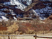
Nine Mile Canyon
Encyclopedia
Canyon
A canyon or gorge is a deep ravine between cliffs often carved from the landscape by a river. Rivers have a natural tendency to reach a baseline elevation, which is the same elevation as the body of water it will eventually drain into. This forms a canyon. Most canyons were formed by a process of...
, approximately 40 mile long, located in the counties
County (United States)
In the United States, a county is a geographic subdivision of a state , usually assigned some governmental authority. The term "county" is used in 48 of the 50 states; Louisiana is divided into parishes and Alaska into boroughs. Parishes and boroughs are called "county-equivalents" by the U.S...
of Carbon
Carbon County, Utah
Carbon County is a county located in the U.S. state of Utah. Named for the major coal deposits in the area, the county seat and largest city, is Price. Carbon County is the second largest natural gas producer in Utah , with 94 billion cubic feet produced in 2008. As of 2010 the population was...
and Duchesne
Duchesne County, Utah
Duchesne County is a county located in the U.S. state of Utah. As of 2010 the population was 18,607, a 29.5% increase over the 2000 figure of 14,371. Its county seat is Duchesne and the largest city is Roosevelt.-Geography:...
in eastern Utah
Utah
Utah is a state in the Western United States. It was the 45th state to join the Union, on January 4, 1896. Approximately 80% of Utah's 2,763,885 people live along the Wasatch Front, centering on Salt Lake City. This leaves vast expanses of the state nearly uninhabited, making the population the...
, in the Western United States
Western United States
.The Western United States, commonly referred to as the American West or simply "the West," traditionally refers to the region comprising the westernmost states of the United States. Because the U.S. expanded westward after its founding, the meaning of the West has evolved over time...
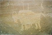
. Promoted as "the world’s longest art gallery," the canyon is known for its extensive rock art
Rock art
Rock art is a term used in archaeology for any human-made markings made on natural stone. They can be divided into:*Petroglyphs - carvings into stone surfaces*Pictographs - rock and cave paintings...
, most of it created by the Fremont culture
Fremont culture
The Fremont culture or Fremont people is a pre-Columbian archaeological culture which received its name from the Fremont River in the U.S. state of Utah where the first Fremont sites were discovered. The Fremont River itself is named for John Charles Frémont, an American explorer. It inhabited...
and the Ute
Ute Tribe
The Ute are an American Indian people now living primarily in Utah and Colorado. There are three Ute tribal reservations: Uintah-Ouray in northeastern Utah ; Southern Ute in Colorado ; and Ute Mountain which primarily lies in Colorado, but extends to Utah and New Mexico . The name of the state of...
people. The rock art, shelters, and granaries
Granary
A granary is a storehouse for threshed grain or animal feed. In ancient or primitive granaries, pottery is the most common use of storage in these buildings. Granaries are often built above the ground to keep the stored food away from mice and other animals.-Early origins:From ancient times grain...
left behind by the Fremont make Nine Mile Canyon a destination for archaeologists
Archaeology
Archaeology, or archeology , is the study of human society, primarily through the recovery and analysis of the material culture and environmental data that they have left behind, which includes artifacts, architecture, biofacts and cultural landscapes...
and tourists alike.
The canyon became a main transport corridor
Transport corridor
A transportation corridor is a tract of land in which at least one main line for transport, be it road, rail or canal, has been built...
in the region during the 1880s. Settlers established a number of ranch
Ranch
A ranch is an area of landscape, including various structures, given primarily to the practice of ranching, the practice of raising grazing livestock such as cattle or sheep for meat or wool. The word most often applies to livestock-raising operations in the western United States and Canada, though...
es in Nine Mile, and even a short-lived town named Harper
Harper, Utah
Harper is a ghost town located in Nine Mile Canyon in the southern part of Duchesne County, Utah, United States. This stagecoach town came into existence in 1886. The nearest inhabited town is Wellington...
. No longer heavily traveled, the rugged canyon road was used mostly for recreation and tourism through the end of the 20th century. The discovery of rich deposits of natural gas
Natural gas
Natural gas is a naturally occurring gas mixture consisting primarily of methane, typically with 0–20% higher hydrocarbons . It is found associated with other hydrocarbon fuel, in coal beds, as methane clathrates, and is an important fuel source and a major feedstock for fertilizers.Most natural...
deep beneath the Tavaputs Plateau has brought an influx of industrial truck traffic since 2002. The large amounts of fugitive dust produced by the trucks' passage may be damaging the rock art. Public debate is ongoing about how best to balance energy development in the canyon against the preservation of its cultural resources.
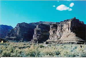
Geography

Book Cliffs
The Book Cliffs are a series of mountains and cliffs in western Colorado and eastern Utah, in the western United States. They are so named because many of them have the triangular appearance of a book that has been opened up, then turned on its sides and set to rest on the open sides of the book,...
, and south and east of Ashley National Forest
Ashley National Forest
Ashley National Forest is a national forest located in northeastern Utah and southwestern Wyoming. Within the Forest’s bounds are of vast forests, lakes, and mountains, with elevations ranging from . The Forest covers portions of Utah; Duchesne; Uintah; Daggett; and Summit counties in Utah and...
. The full 78 miles (125.5 km) canyon route, formerly SR-53 through Gate Canyon, connects the towns of Wellington
Wellington, Utah
Wellington is a city in Carbon County, Utah, United States. The population was 1,666 at the 2000 census. The community was settled in 1878 by a band of thirteen Mormons led by Jefferson Tidwell. The town was named for Justus Wellington Seeley, Jr., of the Emery County Court...
and Myton
Myton, Utah
Myton is a city in Duchesne County, Utah, United States. Established in 1905, Myton had a population of 539 at the 2000 census.-Geography:Myton is located at ....
. Nine Mile Creek, the stream
Stream
A stream is a body of water with a current, confined within a bed and stream banks. Depending on its locale or certain characteristics, a stream may be referred to as a branch, brook, beck, burn, creek, "crick", gill , kill, lick, rill, river, syke, bayou, rivulet, streamage, wash, run or...
that formed the canyon, is by no means a major body of water. Its importance lies in the fact that it is one of the few water sources in the region that are reliable year-round, and it has been so since prehistoric times. Nine Mile Creek is actually a minor tributary
Tributary
A tributary or affluent is a stream or river that flows into a main stem river or a lake. A tributary does not flow directly into a sea or ocean...
of the Green River
Green River (Utah)
The Green River, located in the western United States, is the chief tributary of the Colorado River. The watershed of the river, known as the Green River Basin, covers parts of Wyoming, Utah, and Colorado. The Green River is long, beginning in the Wind River Mountains of Wyoming and flowing...
, emptying into Desolation Canyon
Desolation Canyon (Utah)
Desolation Canyon is a remote canyon on the Green River in the eastern part of the U.S. state of Utah. It was traversed by John Wesley Powell in 1869 as part of an expedition that was sponsored by the Smithsonian Institution....
on the east. A number of tributary canyons branch off Nine Mile itself, including Argyle Canyon, Cottonwood Canyon, Minnie Maud
Minnie Maud
Minnie Maud is the name of a creek and canyon in eastern Utah that is noted as the western starting point of the Nine Mile Canyon petroglyphs section. Minnie Maud Creek is a stream whose headwaters begin where the Western Tavaputs and Wasatch Plateau meet the Uinta Mountains. The creek flows...
, and Dry Canyon. Significant rock art sites are frequently located near the junctions where they meet the main canyon.
Archaeology

North America
North America is a continent wholly within the Northern Hemisphere and almost wholly within the Western Hemisphere. It is also considered a northern subcontinent of the Americas...
. The majority is in the form of pecked petroglyph
Petroglyph
Petroglyphs are pictogram and logogram images created by removing part of a rock surface by incising, picking, carving, and abrading. Outside North America, scholars often use terms such as "carving", "engraving", or other descriptions of the technique to refer to such images...
s, and there are many painted pictographs as well. Researchers have also identified hundreds of pit-house
Pit-house
A pit-house is a dwelling dug into the ground which may also be layered with stone.These structures may be used as places to tell stories, dance, sing, celebrate, and store food. In archaeology, pit-houses are also termed sunken featured buildings and are found in numerous cultures around the world...
s, rock shelters, and granaries
Granary
A granary is a storehouse for threshed grain or animal feed. In ancient or primitive granaries, pottery is the most common use of storage in these buildings. Granaries are often built above the ground to keep the stored food away from mice and other animals.-Early origins:From ancient times grain...
, although only a limited amount of actual excavation has been carried out to date. Many of these structures are located high above the canyon floor on cliff ledges, pinnacles, and mesa
Mesa
A mesa or table mountain is an elevated area of land with a flat top and sides that are usually steep cliffs. It takes its name from its characteristic table-top shape....
s. They were built by the Fremont, whose presence in Nine Mile has been dated at AD 950–1250. Indeed, Nine Mile Canyon was one of the locations most heavily occupied by the Fremont. In contrast to the purely hunter-gatherer
Hunter-gatherer
A hunter-gatherer or forage society is one in which most or all food is obtained from wild plants and animals, in contrast to agricultural societies which rely mainly on domesticated species. Hunting and gathering was the ancestral subsistence mode of Homo, and all modern humans were...
cultures that surrounded them, the Fremont practiced agriculture
Agriculture
Agriculture is the cultivation of animals, plants, fungi and other life forms for food, fiber, and other products used to sustain life. Agriculture was the key implement in the rise of sedentary human civilization, whereby farming of domesticated species created food surpluses that nurtured the...
, growing corn
Maize
Maize known in many English-speaking countries as corn or mielie/mealie, is a grain domesticated by indigenous peoples in Mesoamerica in prehistoric times. The leafy stalk produces ears which contain seeds called kernels. Though technically a grain, maize kernels are used in cooking as a vegetable...
and squash along the canyon bottom. Compared to other Fremont areas, relatively little pottery
Pottery
Pottery is the material from which the potteryware is made, of which major types include earthenware, stoneware and porcelain. The place where such wares are made is also called a pottery . Pottery also refers to the art or craft of the potter or the manufacture of pottery...
is found in Nine Mile, suggesting that bean
Bean
Bean is a common name for large plant seeds of several genera of the family Fabaceae used for human food or animal feed....
s, which must be boiled for hours to become edible, were not an important part of the local diet. The Fremont left irrigation
Irrigation
Irrigation may be defined as the science of artificial application of water to the land or soil. It is used to assist in the growing of agricultural crops, maintenance of landscapes, and revegetation of disturbed soils in dry areas and during periods of inadequate rainfall...
ditches and earthen lodges on the canyon floor that could be seen as late as the 1930s, but are no longer visible after generations of modern cultivation.
Artifact (archaeology)
An artifact or artefact is "something made or given shape by man, such as a tool or a work of art, esp an object of archaeological interest"...
found in Nine Mile, there is no archaeological evidence of any Ute camps or residences.
Archaeological sites
In 2009, 63 archaeological sites in the canyon were listed on the U.S. National Register of Historic PlacesNational Register of Historic Places
The National Register of Historic Places is the United States government's official list of districts, sites, buildings, structures, and objects deemed worthy of preservation...
. Most are named in the National Register listing only by their archaeological site codes. The sites in Carbon County are: 42Cb31, 42Cb33, 42Cb36, 42Cb46, 42Cb48, 42Cb50, 42Cb51, 42Cb52, 42Cb145, 42Cb242, 42Cb690, 42Cb697, 42Cb729, 42Cb730, 42Cb731, 42Cb736, 42Cb743, 42Cb744, 42Cb745, 42Cb746, 42Cb804, 42Cb809, 42Cb811, 42Cb851, 42Cb893, 42Cb969, 42Cb974, 42Cb1252, 42Cb1758, 42Cb2024, 42Cb2043, 42Cb2218, 42Dc706, Cottonwood Village, Drop-Dead Ruin, and First Canyon Site. Those in Duchesne County are: 42Dc306, 42Dc638, 42Dc682, 42Dc683, 42Dc684, 42Dc685, 42Dc686, 42Dc687, 42Dc688, 42Dc696, 42Dc700, 42Dc702, 42Dc703, 42Dc704, 42Dc705, 42Dc708, 42Dc709, 42Dc710, 42Dc712, Centennial House, Fool's Pinnacle, Karen's Cist, Maxies Pad, Nordell's Fort, Redman Village, Sunstone Village, and Taylor's City. The locations and details of these sites are not disclosed by the National Register. The 63 sites include 40 Fremont constructions, 19 rock art sites, and 4 sets of historical-era dwellings.
History
John Wesley Powell
John Wesley Powell was a U.S. soldier, geologist, explorer of the American West, and director of major scientific and cultural institutions...
's second Colorado River
Colorado River
The Colorado River , is a river in the Southwestern United States and northwestern Mexico, approximately long, draining a part of the arid regions on the western slope of the Rocky Mountains. The watershed of the Colorado River covers in parts of seven U.S. states and two Mexican states...
expedition camped at the mouth of the canyon in 1871, and the earliest appearance of the name Nine Mile Canyon is in records of the expedition.
Nine Mile Road was constructed through the canyon in 1886 by the Buffalo Soldiers of the 9th Cavalry Regiment, linking Fort Duchesne to the railroad through the city of Price
Price, Utah
Price is a city in Carbon County, Utah, United States. The city is home to the USU-College of Eastern Utah, as well as the large USU Eastern Prehistoric Museum affiliated with the college. Price is located within short distances from both Nine Mile Canyon and the Manti-La Sal National Forest...
. Use of the road surged in 1889 after the discovery of Gilsonite
Gilsonite
Gilsonite is the registered trademark for a form of natural asphalt found only in the Uintah Basin of Utah; the non-trademarked mineral name is uintaite or uintahite. It is mined in underground shafts and resembles shiny black obsidian...
in the Uinta Basin. This was the main transportation route in eastern Utah until well into the 20th century. Most of the stagecoach
Stagecoach
A stagecoach is a type of covered wagon for passengers and goods, strongly sprung and drawn by four horses, usually four-in-hand. Widely used before the introduction of railway transport, it made regular trips between stages or stations, which were places of rest provided for stagecoach travelers...
, mail, freight, and telegraph traffic into the Uinta Basin passed through Nine Mile until after the arrival of the Uintah Railway
Uintah Railway
The Uintah Railway was a small railroad company in Utah and Colorado in the United States. It operated from 1902 to 1939.-History:The company was founded in 1902 as a wholly owned subsidiary of the Gilson Asphaltum Co. with the sole purpose of building a railroad into the isolated Uintah basin...
around 1905.
The freight trade led to the settlement of the canyon itself. One of the main stagecoach stops developed into a town of sorts. Called Harper
Harper, Utah
Harper is a ghost town located in Nine Mile Canyon in the southern part of Duchesne County, Utah, United States. This stagecoach town came into existence in 1886. The nearest inhabited town is Wellington...
, it included a hotel, store, school, and an unofficial post office. It lacked a formal town site, simply taking in a long stretch of scattered ranches and buildings. The community grew gradually from the 1880s until it was officially established as the town of Harper in 1905. The Harper precinct as a whole had a population of 130 at its peak in 1910, but in the early 1920s Harper became a ghost town
Ghost town
A ghost town is an abandoned town or city. A town often becomes a ghost town because the economic activity that supported it has failed, or due to natural or human-caused disasters such as floods, government actions, uncontrolled lawlessness, war, or nuclear disasters...
.
Current issues
Looting
Looting —also referred to as sacking, plundering, despoiling, despoliation, and pillaging—is the indiscriminate taking of goods by force as part of a military or political victory, or during a catastrophe, such as during war, natural disaster, or rioting...
and malicious vandalism
Vandalism
Vandalism is the behaviour attributed originally to the Vandals, by the Romans, in respect of culture: ruthless destruction or spoiling of anything beautiful or venerable...
are largely a thing of the past. Nine Mile Canyon's rock art is still at risk, however. Carved and painted mainly on weathered sandstone
Sandstone
Sandstone is a sedimentary rock composed mainly of sand-sized minerals or rock grains.Most sandstone is composed of quartz and/or feldspar because these are the most common minerals in the Earth's crust. Like sand, sandstone may be any colour, but the most common colours are tan, brown, yellow,...
panels, the images are susceptible to erosion
Erosion
Erosion is when materials are removed from the surface and changed into something else. It only works by hydraulic actions and transport of solids in the natural environment, and leads to the deposition of these materials elsewhere...
, which is accelerated by touching and by airborne dust. The dust is a special concern as heavy industrial traffic in the canyon increases.
Nine Mile Road, once such an important route, is almost completely unpaved
Pavement (material)
Road surface or pavement is the durable surface material laid down on an area intended to sustain vehicular or foot traffic, such as a road or walkway. In the past cobblestones and granite setts were extensively used, but these surfaces have mostly been replaced by asphalt or concrete. Such...
. In fact, it is considered the poorest of the four old military roads in Duchesne County. Difficult to travel as it is, the U.S. Bureau of Land Management
Bureau of Land Management
The Bureau of Land Management is an agency within the United States Department of the Interior which administers America's public lands, totaling approximately , or one-eighth of the landmass of the country. The BLM also manages of subsurface mineral estate underlying federal, state and private...
(BLM) designated it as a Scenic Backcountry Byway in 1990. But the road itself no longer limits travel in the canyon as it once did. The rapid proliferation of off-road vehicle
Off-road vehicle
An off-road vehicle is considered to be any type of vehicle which is capable of driving on and off paved or gravel surface. It is generally characterized by having large tires with deep, open treads, a flexible suspension, or even caterpillar tracks...
s has brought new access to the canyon's attractions—and new threats to their survival.
Natural gas development
Land use
Land use is the human use of land. Land use involves the management and modification of natural environment or wilderness into built environment such as fields, pastures, and settlements. It has also been defined as "the arrangements, activities and inputs people undertake in a certain land cover...
. As in many rural areas of the Western United States, land in the canyon is a patchwork of public
Public land
In all modern states, some land is held by central or local governments. This is called public land. The system of tenure of public land, and the terminology used, varies between countries...
and private property. Archaeological sites are found on both. Commercially important deposits of mineral
Mineral
A mineral is a naturally occurring solid chemical substance formed through biogeochemical processes, having characteristic chemical composition, highly ordered atomic structure, and specific physical properties. By comparison, a rock is an aggregate of minerals and/or mineraloids and does not...
s and other geological resources have also been discovered, further complicating the issues. Since 2002, the Bill Barrett Corporation
Bill Barrett Corporation
Bill Barrett Corporation is an energy company based in Denver, Colorado. Its core business is natural gas and oil exploration and development in the Rocky Mountains region of the United States....
, in cooperation with the BLM and private landowners, has been pursuing a natural gas exploration project on the West Tavaputs Plateau in and around the canyon. The company estimates the available natural gas reserves at approximately 1 trillion cubic feet (2.8 m³). Bill Barrett Corporation has spent some $2 million on improving area roads, and the complete project, if approved as planned, could create as many as 1000 jobs. Government involvement in the project has been controversial, drawing complaints from conservation
Conservation movement
The conservation movement, also known as nature conservation, is a political, environmental and a social movement that seeks to protect natural resources including animal, fungus and plant species as well as their habitat for the future....
groups that not enough is being done to protect natural and cultural resources.


Magnesium chloride
Magnesium chloride is the name for the chemical compounds with the formulas MgCl2 and its various hydrates MgCl2x. These salts are typical ionic halides, being highly soluble in water. The hydrated magnesium chloride can be extracted from brine or sea water...
on the road as a dust abatement
Dust abatement
Dust abatement refers to the process of inhibiting the creation of excess soil dust, a pollutant that contributes to excess levels of particulate matter....
measure. The compound pulls moisture from the air to dampen dust, but it may be doing more harm than good. Once the dust dries, the magnesium chloride drifts with it onto the rock walls and sticks there. It can crack the rock when it freezes in cold weather. According to a 2007 study commissioned by the BLM and paid for by Bill Barrett Corporation, the magnesium chloride will corrode the rock panels over time, further accelerating the rock art's loss. Trying to clean the dust off the rock may damage it even more.
In 2004, due to concerns about energy development and increasing recreational and tourist traffic, Nine Mile Canyon was named on the National Trust for Historic Preservation
National Trust for Historic Preservation
The National Trust for Historic Preservation is an American member-supported organization that was founded in 1949 by congressional charter to support preservation of historic buildings and neighborhoods through a range of programs and activities, including the publication of Preservation...
's list of America's Most Endangered Places
America's Most Endangered Places
Each year since 1987, the National Trust for Historic Preservation has released a list of places they consider the most endangered in America. The number of sites included on the list has varied, with the most recent lists settling on 11...
. In 2009, 63 sites in the canyon were added to the National Register of Historic Places
National Register of Historic Places
The National Register of Historic Places is the United States government's official list of districts, sites, buildings, structures, and objects deemed worthy of preservation...
, and the BLM has announced plans to nominate some 800 more in years to come.
See also
- National Register of Historic Places listings in Carbon County, UtahNational Register of Historic Places listings in Carbon County, UtahThis is a list of the National Register of Historic Places listings in Carbon County, Utah.This is intended to be a complete list of the properties and districts on the National Register of Historic Places in Carbon County, Utah, United States...
- National Register of Historic Places listings in Duchesne County, UtahNational Register of Historic Places listings in Duchesne County, UtahThis is a list of the National Register of Historic Places listings in Duchesne County, Utah.This is intended to be a complete list of the properties and districts on the National Register of Historic Places in Duchesne County, Utah, United States...
Further reading
A memoir of a young man's experiences on a Nine Mile Canyon ranch in the 1960s.External links
- Exploring Nine Mile Canyon (PDF), brochure with a map and guide
- Nine Mile Canyon - Know Before You Go at BLM
- Nine Mile Canyon Guide and Information
- Nine Mile Canyon Backway at National Scenic BywayNational Scenic BywayA National Scenic Byway is a road recognized by the United States Department of Transportation for its archeological, cultural, historic, natural, recreational, and/or scenic qualities. The program was established by Congress in 1991 to preserve and protect the nation's scenic but often...
s Program - Nine Mile Canyon Coalition, a group dedicated to the preservation of Nine Mile Canyon
- Action Alert from the National Trust for Historic Preservation