
Utah State Route 279
Encyclopedia
State Route 279 is a state highway
in the U.S. state of Utah
. The highway was constructed in 1962–1963 to service the Cane Creek potash mine and processing plant southwest of Moab
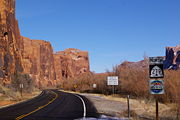
. The highway was named one of the most beautiful highways opened to traffic in 1963. The entire length of SR-279 has been designated the Potash – Lower Colorado River Scenic Byway
by the Utah State Legislature, however is known locally as Potash Road.
This highway was intended to be part of a longer highway, State Route 278, that was to scale the canyon walls between Moab and Dead Horse Point State Park
. Only the connection to the potash mine was constructed before the project was cancelled. Although the highway was constructed to aid the mining industry of southeastern Utah, the road is popular with tourists and four wheel drive
enthusiasts. The jeep trail
s beginning where SR-279 ends are used to access Canyonlands National Park
and Dead Horse Point.
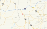
 The highway begins just north of Moab at a junction with U.S. Route 191 near the southern boundary of Arches National Park
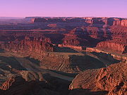
. The road follows the north bank of the Colorado River
to the potash mine. The road is legislatively designated north–south, but actually serpentines
for most of its length. The highway loosely parallels a spur of the Denver and Rio Grande Railroad built at the same time and for the same purpose of serving the potash mine. The route of the railroad features a 1.59 miles (2.56 km) tunnel that bypasses most of the serpentine bends in the Colorado River
between Moab and the potash plant. While in the Colorado River canyon, the highway passes by dinosaur footprints, Indian petroglyphs and jeep trail
s leading to Canyonlands National Park
and Dead Horse Point State Park
. The highway also passes by three named natural arch
es, Corona Arch, Bow Tie Arch, and Jug Handle Arch.
 The State Road Commission approved a new State Route 279 in 1960, connecting US-160 (now US-191) northwest of Moab with Dead Horse Point State Park
. The route would be mostly new construction, following the right (northwest) bank of the Colorado River
to Day Canyon, where it would climb to the southwest onto the plateau containing the park. Within the park, an existing roadway, then its primary access road, would become part of SR-279. The state legislature approved this highway in 1961. Later that year, the commission added a second route—State Route 278—that would continue south alongside the river from SR-279 to the Grand-San Juan County line. However, when it approved the addition in 1963, the legislature made it part of SR-279, renumbering the spur to the park through Day Canyon as SR-278. In addition, the south end of SR-279 was changed to Potash, a point north of the county line where the Texas Gulf Sulphur Company was building a potash
plant. SR-279 was soon built, but the road through Day Canyon was never constructed. In 1975, the legislature deleted SR-278 in favor of a new SR-313, which followed the existing county road to Dead Horse Point through Sevenmile Canyon.
In 1963, Parade Magazine held the third of an annual competition for most scenic highway that opened to traffic that year. SR-279 was one of four finalists in the competition. The others finalists were I-93 between Windham
and Londonderry
in New Hampshire
, I-84 near Southington, Connecticut
and I-405
near Sepulveda Pass
in Los Angeles, California
.
State highway
State highway, state road or state route can refer to one of three related concepts, two of them related to a state or provincial government in a country that is divided into states or provinces :#A...
in the U.S. state of Utah
Utah
Utah is a state in the Western United States. It was the 45th state to join the Union, on January 4, 1896. Approximately 80% of Utah's 2,763,885 people live along the Wasatch Front, centering on Salt Lake City. This leaves vast expanses of the state nearly uninhabited, making the population the...
. The highway was constructed in 1962–1963 to service the Cane Creek potash mine and processing plant southwest of Moab
Moab, Utah
Moab is a city in Grand County, in eastern Utah, in the western United States. The population was 4,779 at the 2000 census. It is the county seat and largest city in Grand County. Moab hosts a large number of tourists every year, mostly visitors to the nearby Arches and Canyonlands National Parks...
. The highway was named one of the most beautiful highways opened to traffic in 1963. The entire length of SR-279 has been designated the Potash – Lower Colorado River Scenic Byway
Utah Scenic Byways
The legislature in the U.S. state of Utah has designated a system of Utah Scenic Byways in addition to the National Scenic Byways that are defined within the state. Some of the state designated routes overlap with the federal designations...
by the Utah State Legislature, however is known locally as Potash Road.
This highway was intended to be part of a longer highway, State Route 278, that was to scale the canyon walls between Moab and Dead Horse Point State Park
Dead Horse Point State Park
Dead Horse Point State Park is a state park of Utah, USA, featuring a dramatic overlook of the Colorado River and Canyonlands National Park. The park is so named because of its use as a natural corral by cowboys in the 19th century...
. Only the connection to the potash mine was constructed before the project was cancelled. Although the highway was constructed to aid the mining industry of southeastern Utah, the road is popular with tourists and four wheel drive
Four Wheel Drive
The Four Wheel Drive Auto Company, more often known as Four Wheel Drive or just FWD, was founded in 1909 in Clintonville, Wisconsin, as the Badger Four-Wheel Drive Auto Company by Otto Zachow and William Besserdich.-History:...
enthusiasts. The jeep trail
Jeep trail
Roads that are only suitable for off-road vehicles are often called jeep trails.The most famous is the Rubicon Trail located near Lake Tahoe in California. The so-called "Jeep Trail Capital of the World," however, is Ouray, Colorado...
s beginning where SR-279 ends are used to access Canyonlands National Park
Canyonlands National Park
Canyonlands National Park is a U.S. National Park located in southeastern Utah near the town of Moab and preserves a colorful landscape eroded into countless canyons, mesas and buttes by the Colorado River, the Green River, and their respective tributaries. The park is divided into four districts:...
and Dead Horse Point.
Route description
Arches National Park
Arches National Park is a U.S. National Park in eastern Utah. It is known for preserving over 2000 natural sandstone arches, including the world-famous Delicate Arch, in addition to a variety of unique geological resources and formations....
. The road follows the north bank of the Colorado River
Colorado River
The Colorado River , is a river in the Southwestern United States and northwestern Mexico, approximately long, draining a part of the arid regions on the western slope of the Rocky Mountains. The watershed of the Colorado River covers in parts of seven U.S. states and two Mexican states...
to the potash mine. The road is legislatively designated north–south, but actually serpentines
Serpentine shape
Serpentine refers to the curved shape of an object or design which resembles the letter s, a sine wave or a snake; the latter is the derivation of the term.- Examples :* The Serpentine River...
for most of its length. The highway loosely parallels a spur of the Denver and Rio Grande Railroad built at the same time and for the same purpose of serving the potash mine. The route of the railroad features a 1.59 miles (2.56 km) tunnel that bypasses most of the serpentine bends in the Colorado River
Colorado River
The Colorado River , is a river in the Southwestern United States and northwestern Mexico, approximately long, draining a part of the arid regions on the western slope of the Rocky Mountains. The watershed of the Colorado River covers in parts of seven U.S. states and two Mexican states...
between Moab and the potash plant. While in the Colorado River canyon, the highway passes by dinosaur footprints, Indian petroglyphs and jeep trail
Jeep trail
Roads that are only suitable for off-road vehicles are often called jeep trails.The most famous is the Rubicon Trail located near Lake Tahoe in California. The so-called "Jeep Trail Capital of the World," however, is Ouray, Colorado...
s leading to Canyonlands National Park
Canyonlands National Park
Canyonlands National Park is a U.S. National Park located in southeastern Utah near the town of Moab and preserves a colorful landscape eroded into countless canyons, mesas and buttes by the Colorado River, the Green River, and their respective tributaries. The park is divided into four districts:...
and Dead Horse Point State Park
Dead Horse Point State Park
Dead Horse Point State Park is a state park of Utah, USA, featuring a dramatic overlook of the Colorado River and Canyonlands National Park. The park is so named because of its use as a natural corral by cowboys in the 19th century...
. The highway also passes by three named natural arch
Natural arch
A natural arch or natural bridge is a natural geological formation where a rock arch forms, with an opening underneath. Most natural arches form as a narrow ridge, walled by cliffs, become narrower from erosion, with a softer rock stratum under the cliff-forming stratum gradually eroding out until...
es, Corona Arch, Bow Tie Arch, and Jug Handle Arch.
History
Dead Horse Point State Park
Dead Horse Point State Park is a state park of Utah, USA, featuring a dramatic overlook of the Colorado River and Canyonlands National Park. The park is so named because of its use as a natural corral by cowboys in the 19th century...
. The route would be mostly new construction, following the right (northwest) bank of the Colorado River
Colorado River
The Colorado River , is a river in the Southwestern United States and northwestern Mexico, approximately long, draining a part of the arid regions on the western slope of the Rocky Mountains. The watershed of the Colorado River covers in parts of seven U.S. states and two Mexican states...
to Day Canyon, where it would climb to the southwest onto the plateau containing the park. Within the park, an existing roadway, then its primary access road, would become part of SR-279. The state legislature approved this highway in 1961. Later that year, the commission added a second route—State Route 278—that would continue south alongside the river from SR-279 to the Grand-San Juan County line. However, when it approved the addition in 1963, the legislature made it part of SR-279, renumbering the spur to the park through Day Canyon as SR-278. In addition, the south end of SR-279 was changed to Potash, a point north of the county line where the Texas Gulf Sulphur Company was building a potash
Potash
Potash is the common name for various mined and manufactured salts that contain potassium in water-soluble form. In some rare cases, potash can be formed with traces of organic materials such as plant remains, and this was the major historical source for it before the industrial era...
plant. SR-279 was soon built, but the road through Day Canyon was never constructed. In 1975, the legislature deleted SR-278 in favor of a new SR-313, which followed the existing county road to Dead Horse Point through Sevenmile Canyon.
In 1963, Parade Magazine held the third of an annual competition for most scenic highway that opened to traffic that year. SR-279 was one of four finalists in the competition. The others finalists were I-93 between Windham
Windham, New Hampshire
Windham is a town in Rockingham County, New Hampshire, United States. The population was 13,592 at the 2010 census.- History :The area was initially home to the Pawtucket Native Americans. Scottish immigrants began to settle in the area in 1719. The region was known as “Nutfield” and included what...
and Londonderry
Londonderry, New Hampshire
-Demographics:As of the census of 2000, there were 23,236 people, 7,623 households, and 6,319 families residing in the town. The population density was 555.8 people per square mile . There were 7,718 housing units at an average density of 184.6 per square mile...
in New Hampshire
New Hampshire
New Hampshire is a state in the New England region of the northeastern United States of America. The state was named after the southern English county of Hampshire. It is bordered by Massachusetts to the south, Vermont to the west, Maine and the Atlantic Ocean to the east, and the Canadian...
, I-84 near Southington, Connecticut
Southington, Connecticut
Southington is a town in Hartford County, Connecticut, United States. It is part of Connecticut's 1st congressional district. It is situated about 20 miles southwest of Hartford, about 80 miles northeast of New York City, 105 miles southwest of Boston and 77 miles west of Providence...
and I-405
Interstate 405 (California)
Interstate 405 is a major north–south Interstate Highway in Southern California. It is a bypass of Interstate 5, running along the western areas of the Greater Los Angeles Area from Irvine in the south to near San Fernando in the north...
near Sepulveda Pass
Sepulveda Pass
Sepulveda Pass is a mountain pass through the Santa Monica Mountains in Los Angeles.It connects the Los Angeles Basin to the San Fernando Valley via the San Diego Freeway and Sepulveda Boulevard and experiences heavy traffic on a regular basis, commonly experiencing major traffic slowdowns and...
in Los Angeles, California
Los Angeles, California
Los Angeles , with a population at the 2010 United States Census of 3,792,621, is the most populous city in California, USA and the second most populous in the United States, after New York City. It has an area of , and is located in Southern California...
.
Major intersections
Note: The entire route is located in rural Grand CountyGrand County, Utah
Grand County is a county located in the U.S. state of Utah. As of 2000 the population was 8,485, and by 2005 had been estimated at 8,743. It was named for the Colorado River, which at the time of statehood was known as the Grand River. Its county seat and largest city is Moab.-Geography:According...
| Mile | Junction | Notes |
|---|---|---|
| 0.000 | Potash Plant | Route begins |
| 1.678 | Jug Handle Arch View area | |
| 5.123 | Gold Bar Recreation Area and Campgrounds | |
| 5.294 | Corona Arch/ Bow Tie Arch parking area | |
| 9.390 | Dinosaur Footprints View Area/Poison Spider Mesa Trailhead | |
| 9.726 | Williams Bottom Camping Area | |
| 11.184 | Jaycee Park Recreation Site | |
| 15.178 | , To I-70 Interstate 70 in Utah Interstate 70 is a mainline route of the Interstate Highway System in the United States connecting Utah and Maryland. The Utah section runs east–west for across the central part of the state. Richfield is the largest Utah city served by the freeway, which does not serve or connect any urban areas... |