

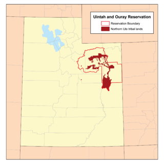
Uintah and Ouray Indian Reservation
Encyclopedia
Utah
Utah is a state in the Western United States. It was the 45th state to join the Union, on January 4, 1896. Approximately 80% of Utah's 2,763,885 people live along the Wasatch Front, centering on Salt Lake City. This leaves vast expanses of the state nearly uninhabited, making the population the...
, USA. It is the homeland of the Northern Ute Tribe
Ute Indian Tribe of the Uintah and Ouray Reservation
The Ute Indian Tribe of the Uintah and Ouray Reservation is a federally recognized tribe of Ute Indians in Utah. The Uintah are a western band of Ute.-Government:The Uintah and Ouray Reservation headquarters is located in Fort Duchesne, Utah....
, and is the largest of three Indian reservation
Indian reservation
An American Indian reservation is an area of land managed by a Native American tribe under the United States Department of the Interior's Bureau of Indian Affairs...
s inhabited by members of the Ute Tribe
Ute Tribe
The Ute are an American Indian people now living primarily in Utah and Colorado. There are three Ute tribal reservations: Uintah-Ouray in northeastern Utah ; Southern Ute in Colorado ; and Ute Mountain which primarily lies in Colorado, but extends to Utah and New Mexico . The name of the state of...
of Native Americans
Native Americans in the United States
Native Americans in the United States are the indigenous peoples in North America within the boundaries of the present-day continental United States, parts of Alaska, and the island state of Hawaii. They are composed of numerous, distinct tribes, states, and ethnic groups, many of which survive as...
. It lies in parts of seven counties; in descending order of land area they are: Uintah
Uintah County, Utah
This page deals with the Utah County. For the Wyoming County, see Uinta County, Wyoming.Uintah County is a county located in the U.S. state of Utah. As of 2000 the population was 25,224 and by 2009 was estimated at 31,536. It was named for the Ute Indians, the tribe that lives in the basin. Its...
, Duchesne
Duchesne County, Utah
Duchesne County is a county located in the U.S. state of Utah. As of 2010 the population was 18,607, a 29.5% increase over the 2000 figure of 14,371. Its county seat is Duchesne and the largest city is Roosevelt.-Geography:...
, Wasatch
Wasatch County, Utah
Wasatch County is a county located in the U.S. state of Utah. It was named for a Ute Indian word meaning mountain pass or low place in the high mountains. Its county seat and largest city is Heber City.The county is governed by a county council with an appointed county manager.Wasatch County is...
, Grand
Grand County, Utah
Grand County is a county located in the U.S. state of Utah. As of 2000 the population was 8,485, and by 2005 had been estimated at 8,743. It was named for the Colorado River, which at the time of statehood was known as the Grand River. Its county seat and largest city is Moab.-Geography:According...
, Carbon
Carbon County, Utah
Carbon County is a county located in the U.S. state of Utah. Named for the major coal deposits in the area, the county seat and largest city, is Price. Carbon County is the second largest natural gas producer in Utah , with 94 billion cubic feet produced in 2008. As of 2010 the population was...
, Utah
Utah County, Utah
Utah County is a county located in the U.S. state of Utah. As of 2000, the population was 368,536 and by 2008 was estimated at 530,837. It was named for the Spanish name for the Ute Indians. The county seat and largest city is Provo...
, and Emery
Emery County, Utah
Emery County is a county located in the U.S. state of Utah. As of 2000 the population was 10,860, and by 2009 had been estimated to decrease to 10,629. It was named for George W. Emery, governor of the Utah Territory in 1875...
counties. The total land area is 6,769.173 sq mi (17,532.078 km²) and there was a population of 19,182 persons living on its territory as of the 2000 census
United States Census, 2000
The Twenty-second United States Census, known as Census 2000 and conducted by the Census Bureau, determined the resident population of the United States on April 1, 2000, to be 281,421,906, an increase of 13.2% over the 248,709,873 persons enumerated during the 1990 Census...
. It is the second-largest Indian reservation in land area, smaller than only the Navajo Indian Reservation. Tribal headquarters are in Fort Duchesne
Fort Duchesne, Utah
Fort Duchesne is a census-designated place in Uintah County, Utah, United States. The population was 621 at the 2000 census, a slight decrease from the 1990 figure of 655...
, located in Uintah County, Utah
Uintah County, Utah
This page deals with the Utah County. For the Wyoming County, see Uinta County, Wyoming.Uintah County is a county located in the U.S. state of Utah. As of 2000 the population was 25,224 and by 2009 was estimated at 31,536. It was named for the Ute Indians, the tribe that lives in the basin. Its...
. The largest community on its territory is the city of Roosevelt
Roosevelt, Utah
Roosevelt is a city in Duchesne County, Utah, United States. The population was 4,299 at the 2000 census.The proper pronunciation of the city's name is based on how President Theodore Roosevelt pronounced his name: according to the man himself, "pronounced as if it was spelled...
, although most of its residents are not of Native American heritage.
Communities
- AltamontAltamont, UtahAltamont is a town in Duchesne County, Utah, United States. The population was 178 at the 2000 census, an increase over the 1990 figure of 167.-History:...
- BallardBallard, UtahBallard is a town in Uintah County, Utah, United States. The population was 566 at the 2000 census, a decrease of 78 persons from the 1990 population of 644.-Geography:Ballard is located at ....
- DuchesneDuchesne, UtahDuchesne is a city in and the county seat of Duchesne County, Utah, United States. The population was 1,690 at the 2010 census.-Geography:Duchesne city is located at . just west of the junction of the Strawberry and Duchesne rivers in the Uintah Basin of northeastern Utah...
- Fort DuchesneFort Duchesne, UtahFort Duchesne is a census-designated place in Uintah County, Utah, United States. The population was 621 at the 2000 census, a slight decrease from the 1990 figure of 655...
- MytonMyton, UtahMyton is a city in Duchesne County, Utah, United States. Established in 1905, Myton had a population of 539 at the 2000 census.-Geography:Myton is located at ....
- NeolaNeola, UtahNeola is a census-designated place in Duchesne County, Utah, United States. The population was 533 at the 2000 census, a slight increase from the 1990 population of 511...
- RandlettRandlett, UtahRandlett is a census-designated place in Uintah County, Utah, United States. In the 2000 census its population was 224, a 21% decrease from the 1990 figure of 283.Randlett began as the site of a school for Ute children in 1892.-Geography:...
- BluebellBluebell, UtahBluebell is a census-designated place in eastern Duchesne County, Utah, United States, on the Uintah and Ouray Indian Reservation. The population as of the 2010 Census was 293. It lies along local roads east of State Route 87, northeast of the city of Duchesne, the county seat of Duchesne County. ...
- RooseveltRoosevelt, UtahRoosevelt is a city in Duchesne County, Utah, United States. The population was 4,299 at the 2000 census.The proper pronunciation of the city's name is based on how President Theodore Roosevelt pronounced his name: according to the man himself, "pronounced as if it was spelled...
- TabionaTabiona, UtahTabiona is a town in Duchesne County, Utah, United States. The population was 149 at the 2000 census.-History:Tabiona was named for a Ute chief, Chief Tabby-To-Kwanah. The nearby town of Hanna was named after the first postmaster, William P. Hanna...
- WhiterocksWhiterocks, UtahWhiterocks is a census-designated place in Uintah County, Utah, United States. The population was 341 at the 2000 census, a slight increase over the 1990 population of 312.-Geography:Whiterocks is located at ....
See also
- Southern Ute Indian ReservationSouthern Ute Indian ReservationThe Southern Ute Indian Reservation lies in southwestern Colorado, USA, along the northern border of New Mexico. Its territory consists of land from three counties; in descending order of surface area they are La Plata, Archuleta, and Montezuma Counties. The reservation has a land area of 1,058.785...
- Ute Mountain Ute Indian Reservation
- Ouray National Wildlife RefugeOuray National Wildlife RefugeOuray National Wildlife Refuge is a wildlife refuge in central Uintah County, Utah in the northeastern part of the state...