
Dallas tornado outbreak of April 1957
Encyclopedia
The April 1957 Dallas tornado outbreak was a deadly tornado outbreak
that struck most of the Southern United States
from April 2 to the early hours of April 4, 1957. The outbreak was most notable due to a tornado
that hit a densely populated area of the Dallas
Metropolitan area, while other deadly tornadoes struck portions of Mississippi
, Texas
, and Oklahoma
. The two-day outbreak killed at least 19 across 3 states and produced 50 tornadoes from Texas to Tennessee
.
and Oklahoma
panhandles with a warm front
stretching into central Arkansas
and a cold front
stretching into western Texas east of El Paso
, Lubbock
, and Amarillo
. Temperatures on that day reached the 70s in northern Texas with dewpoints in the upper 60s to near 70 degrees Fahrenheit. A strong upper level jet
, abundant instability
in the atmosphere, and substantial wind shear
provided additional fuel for the development of supercell
ular storms across the region.
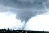
At around 3:00 PM CST, the first tornadoes touched down north of the Dallas-Fort Worth Metroplex area. At around 4:30 CST, a tornado touched down in southern Dallas County
(south of modern-day Interstate 20
) and traveled northward for about 45 minutes through the Dallas neighborhoods of Oak Cliff, Kessler Park
, West Dallas (just west of Downtown Dallas
) and Love Field
before lifting over Bachman Lake
(west of Dallas Love Field Airport) just after 5:00 PM CST. Ten people were killed and 200 others injured by the F3 tornado; damage was estimated at around $4 million (in 1957 dollars). Nearly 600 structures were damaged including over 100 homes and a dozen apartment buildings. Some businesses and schools were also damaged but the Parkland Memorial Hospital
was narrowly spared by the tornado as was the Dallas Love Field Airport. Another tornado in Collin County
north of the city also caused extensive damage.
The tornado was heavily documented and photographed by several eye-witnesses as it was clearly visible throughout most of its 17-mile path through residential and commercial areas of Dallas up to near Love Field Airport. At that time, it was the most observed tornado ever. A researcher from the Severe Weather Forecast Unit in Kansas City
noticed that several old theories were proven false during the Dallas tornado. One of the theories was that all air and debris flow inward into the funnel and then upward, but on the outside edges of the funnel debris and people were even lifted. WFAA-TV
in Dallas produced a 30-minute documentary about the tornado about one week later.
Another major tornado event struck the densely populated areas of the Dallas–Fort Worth Metroplex
on March 28, 2000 when F3 tornadoes
struck Downtown Fort Worth
as well as Arlington
killing at least 3 and injuring dozens of people while damaging or destroying several structures including several office towers. Additional tornadoes that touched down near the Metroplex area the following morning in Fort Worth
and other areas but no additional fatalities were reported.
, Bryan
and Murray
Counties in Oklahoma and Smith County
in Mississippi. 5 of the fatalities in Oklahoma were from the 2 F4 tornadoes that occurred during the outbreak. The activity shifted further east into the southern Mississippi River
Valley as well as the Tennessee Valley
on April 3 and the early hours of April 4 before activity ceased.
Tornado outbreak
While there is no single agreed upon definition, generally at least 6-10 tornadoes produced by the same synoptic scale weather system is considered a tornado outbreak. The tornadoes usually occur within the same day, or continue into the early morning hours of the succeeding day, and within the...
that struck most of the Southern United States
United States
The United States of America is a federal constitutional republic comprising fifty states and a federal district...
from April 2 to the early hours of April 4, 1957. The outbreak was most notable due to a tornado
Tornado
A tornado is a violent, dangerous, rotating column of air that is in contact with both the surface of the earth and a cumulonimbus cloud or, in rare cases, the base of a cumulus cloud. They are often referred to as a twister or a cyclone, although the word cyclone is used in meteorology in a wider...
that hit a densely populated area of the Dallas
Dallas, Texas
Dallas is the third-largest city in Texas and the ninth-largest in the United States. The Dallas-Fort Worth Metroplex is the largest metropolitan area in the South and fourth-largest metropolitan area in the United States...
Metropolitan area, while other deadly tornadoes struck portions of Mississippi
Mississippi
Mississippi is a U.S. state located in the Southern United States. Jackson is the state capital and largest city. The name of the state derives from the Mississippi River, which flows along its western boundary, whose name comes from the Ojibwe word misi-ziibi...
, Texas
Texas
Texas is the second largest U.S. state by both area and population, and the largest state by area in the contiguous United States.The name, based on the Caddo word "Tejas" meaning "friends" or "allies", was applied by the Spanish to the Caddo themselves and to the region of their settlement in...
, and Oklahoma
Oklahoma
Oklahoma is a state located in the South Central region of the United States of America. With an estimated 3,751,351 residents as of the 2010 census and a land area of 68,667 square miles , Oklahoma is the 28th most populous and 20th-largest state...
. The two-day outbreak killed at least 19 across 3 states and produced 50 tornadoes from Texas to Tennessee
Tennessee
Tennessee is a U.S. state located in the Southeastern United States. It has a population of 6,346,105, making it the nation's 17th-largest state by population, and covers , making it the 36th-largest by total land area...
.
Meteorological synopsis
On April 2, a low pressure system was situated over the TexasTexas Panhandle
The Texas Panhandle is a region of the U.S. state of Texas consisting of the northernmost 26 counties in the state. The panhandle is a rectangular area bordered by New Mexico to the west and Oklahoma to the north and east...
and Oklahoma
Oklahoma Panhandle
The Oklahoma Panhandle is the extreme western region of the state of Oklahoma, comprising Cimarron County, Texas County, and Beaver County. Its name comes from the similarity of shape to the handle of a cooking pan....
panhandles with a warm front
Warm front
A warm front is a density discontinuity located at the leading edge of a homogeneous warm air mass, and is typically located on the equator-facing edge of an isotherm gradient...
stretching into central Arkansas
Arkansas
Arkansas is a state located in the southern region of the United States. Its name is an Algonquian name of the Quapaw Indians. Arkansas shares borders with six states , and its eastern border is largely defined by the Mississippi River...
and a cold front
Cold front
A cold front is defined as the leading edge of a cooler mass of air, replacing a warmer mass of air.-Development of cold front:The cooler and denser air wedges under the less-dense warmer air, lifting it...
stretching into western Texas east of El Paso
El Paso, Texas
El Paso, is a city in and the county seat of El Paso County, Texas, United States, and lies in far West Texas. In the 2010 census, the city had a population of 649,121. It is the sixth largest city in Texas and the 19th largest city in the United States...
, Lubbock
Lubbock, Texas
Lubbock is a city in and the county seat of Lubbock County, Texas, United States. The city is located in the northwestern part of the state, a region known historically as the Llano Estacado, and the home of Texas Tech University and Lubbock Christian University...
, and Amarillo
Amarillo, Texas
Amarillo is the 14th-largest city, by population, in the state of Texas, the largest in the Texas Panhandle, and the seat of Potter County. A portion of the city extends into Randall County. The population was 190,695 at the 2010 census...
. Temperatures on that day reached the 70s in northern Texas with dewpoints in the upper 60s to near 70 degrees Fahrenheit. A strong upper level jet
Jet stream
Jet streams are fast flowing, narrow air currents found in the atmospheres of some planets, including Earth. The main jet streams are located near the tropopause, the transition between the troposphere and the stratosphere . The major jet streams on Earth are westerly winds...
, abundant instability
Instability
In numerous fields of study, the component of instability within a system is generally characterized by some of the outputs or internal states growing without bounds...
in the atmosphere, and substantial wind shear
Wind shear
Wind shear, sometimes referred to as windshear or wind gradient, is a difference in wind speed and direction over a relatively short distance in the atmosphere...
provided additional fuel for the development of supercell
Supercell
A supercell is a thunderstorm that is characterized by the presence of a mesocyclone: a deep, continuously-rotating updraft. For this reason, these storms are sometimes referred to as rotating thunderstorms...
ular storms across the region.
The Dallas tornado
| State | Total | County | County total |
|---|---|---|---|
| Mississippi Mississippi Mississippi is a U.S. state located in the Southern United States. Jackson is the state capital and largest city. The name of the state derives from the Mississippi River, which flows along its western boundary, whose name comes from the Ojibwe word misi-ziibi... |
1 | Smith Smith County, Mississippi -Demographics:As of the census of 2000, there were 16,182 people, 6,046 households, and 4,558 families residing in the county. The population density was 25 people per square mile . There were 7,005 housing units at an average density of 11 per square mile... |
1 |
| Oklahoma Oklahoma Oklahoma is a state located in the South Central region of the United States of America. With an estimated 3,751,351 residents as of the 2010 census and a land area of 68,667 square miles , Oklahoma is the 28th most populous and 20th-largest state... |
6 | Bryan Bryan County, Oklahoma Bryan County is a county located in the U.S. state of Oklahoma. The population was 36,534 at the 2000 census. Its county seat is Durant. The county shares the same boundaries as the Durant Micropolitan Area. It is also home to the headquarters of the Choctaw Nation of Oklahoma located in Durant... |
3 |
| Marshall Marshall County, Oklahoma Marshall County is a county located in the U.S. state of Oklahoma. As of 2000, the population was 13,184. Its county seat is Madill. The county's population grew at a rate of 35% in the 1990s and now it has a new population estimate at 20,000. Marshall County is the fastest growing county in... |
2 | ||
| Murray Murray County, Oklahoma Murray County is a county located in the U.S. state of Oklahoma. As of 2000, the population was 12,623. Its county seat is Sulphur.-Geography:... |
1 | ||
| Texas Texas Texas is the second largest U.S. state by both area and population, and the largest state by area in the contiguous United States.The name, based on the Caddo word "Tejas" meaning "friends" or "allies", was applied by the Spanish to the Caddo themselves and to the region of their settlement in... |
12 | Dallas Dallas County, Texas As of the census of 2000, there were 2,218,899 people, 807,621 households, and 533,837 families residing in the county. The population density was 2,523 people per square mile . There were 854,119 housing units at an average density of 971/sq mi... |
10 |
| Delta | 1 | ||
| Lamar | 1 | ||
| Totals | 19 | ||
| All deaths were tornado-related | |||
At around 3:00 PM CST, the first tornadoes touched down north of the Dallas-Fort Worth Metroplex area. At around 4:30 CST, a tornado touched down in southern Dallas County
Dallas County, Texas
As of the census of 2000, there were 2,218,899 people, 807,621 households, and 533,837 families residing in the county. The population density was 2,523 people per square mile . There were 854,119 housing units at an average density of 971/sq mi...
(south of modern-day Interstate 20
Interstate 20
Interstate 20 is a major east–west Interstate Highway in the Southern United States. I‑20 runs 1,535 miles from near Kent, Texas, at Interstate 10 to Florence, South Carolina, at Interstate 95...
) and traveled northward for about 45 minutes through the Dallas neighborhoods of Oak Cliff, Kessler Park
Kessler, Dallas
The Kessler community is a group of neighborhoods named for George E. Kessler in the Oak Cliff area of Dallas, Texas . Neighborhoods in the area include Kessler Highlands, Kessler Park Estates, Kessler Square, East Kessler Park, West Kessler, and Kessler Plaza.Kessler Park is the principal area...
, West Dallas (just west of Downtown Dallas
Downtown Dallas
Downtown Dallas is the Central Business District in Dallas, Texas USA, located in the geographic center of the city. The area termed "Downtown" has traditionally been defined as bounded by the downtown freeway loop: bounded on the east by I-345 Downtown Dallas is the Central Business District...
) and Love Field
Love Field, Dallas, Texas (neighborhood)
Love Field is a neighborhood located in northwest Dallas, Texas . It lies southwest of and is adjacent to Dallas Love Field Airport and is bounded by Denton Road, Inwood Road, Harry Hines Boulevard, and Webb Chapel Extension. The neighborhood takes its name from Love Field Airport.- Economy :The...
before lifting over Bachman Lake
Bachman Lake
Bachman Lake is a small freshwater lake located in the Love Field neighborhood of northwest Dallas, Texas . It covers in northwest Dallas and lies on the northwest boundary of Dallas Love Field in the airport's landing path...
(west of Dallas Love Field Airport) just after 5:00 PM CST. Ten people were killed and 200 others injured by the F3 tornado; damage was estimated at around $4 million (in 1957 dollars). Nearly 600 structures were damaged including over 100 homes and a dozen apartment buildings. Some businesses and schools were also damaged but the Parkland Memorial Hospital
Parkland Memorial Hospital
Parkland Memorial Hospital is a hospital located at 5201 Harry Hines Boulevard, just west of Oak Lawn in Dallas, Texas . It is the main hospital of the Dallas County Hospital District and serves as Dallas County's public hospital.- History :The original hospital opened in 1894 in a wooden...
was narrowly spared by the tornado as was the Dallas Love Field Airport. Another tornado in Collin County
Collin County, Texas
As of the census of 2000, there were 491,675 people, 181,970 households, and 132,292 families residing in the county. The population density was 580 people per square mile . There were 194,892 housing units at an average density of 230 per square mile...
north of the city also caused extensive damage.
The tornado was heavily documented and photographed by several eye-witnesses as it was clearly visible throughout most of its 17-mile path through residential and commercial areas of Dallas up to near Love Field Airport. At that time, it was the most observed tornado ever. A researcher from the Severe Weather Forecast Unit in Kansas City
Kansas City, Missouri
Kansas City, Missouri is the largest city in the U.S. state of Missouri and is the anchor city of the Kansas City Metropolitan Area, the second largest metropolitan area in Missouri. It encompasses in parts of Jackson, Clay, Cass, and Platte counties...
noticed that several old theories were proven false during the Dallas tornado. One of the theories was that all air and debris flow inward into the funnel and then upward, but on the outside edges of the funnel debris and people were even lifted. WFAA-TV
WFAA-TV
WFAA, channel 8, is an ABC-affiliated television station serving the Dallas–Fort Worth Metroplex, one of the top ten media markets in North America. The station is the flagship of Belo Corporation and the largest ABC affiliate not owned and operated by the network...
in Dallas produced a 30-minute documentary about the tornado about one week later.
Another major tornado event struck the densely populated areas of the Dallas–Fort Worth Metroplex
Dallas–Fort Worth metroplex
The Dallas–Fort Worth–Arlington Metropolitan Statistical Area, a title designated by the U.S. Census as of 2003, encompasses 12 counties within the U.S. state of Texas. The area is divided into two metropolitan divisions: Dallas–Plano–Irving and Fort Worth–Arlington. Residents of the area...
on March 28, 2000 when F3 tornadoes
Fort Worth Tornado
The Great 2000 Fort Worth Tornado occurred on March 28, 2000, moving eastward through the downtown area of Fort Worth, Texas .The tornado passed through the west side of Fort Worth at about 6:18 p.m. It tore a 4-mile path through the city, blowing out windows and causing significant damage to many...
struck Downtown Fort Worth
Downtown Fort Worth
Downtown Fort Worth is the central business district of Fort Worth, Texas, United States.* Sundance Square - Fort Worth's downtown has is an 8 block entertainment district for the city. The Square has brick-pavers, sidewalk cafes, and landscaping which set it apart...
as well as Arlington
Arlington, Texas
Arlington is a city in Tarrant County, Texas within the Dallas–Fort Worth metropolitan area. According to the 2010 census results, the city had a population of 365,438, making it the third largest municipality in the Metroplex...
killing at least 3 and injuring dozens of people while damaging or destroying several structures including several office towers. Additional tornadoes that touched down near the Metroplex area the following morning in Fort Worth
Fort Worth, Texas
Fort Worth is the 16th-largest city in the United States of America and the fifth-largest city in the state of Texas. Located in North Central Texas, just southeast of the Texas Panhandle, the city is a cultural gateway into the American West and covers nearly in Tarrant, Parker, Denton, and...
and other areas but no additional fatalities were reported.
Other tornadoes
Other killer tornadoes touched down in Lamar and Delta Counties in Texas, MarshallMarshall County, Oklahoma
Marshall County is a county located in the U.S. state of Oklahoma. As of 2000, the population was 13,184. Its county seat is Madill. The county's population grew at a rate of 35% in the 1990s and now it has a new population estimate at 20,000. Marshall County is the fastest growing county in...
, Bryan
Bryan County, Oklahoma
Bryan County is a county located in the U.S. state of Oklahoma. The population was 36,534 at the 2000 census. Its county seat is Durant. The county shares the same boundaries as the Durant Micropolitan Area. It is also home to the headquarters of the Choctaw Nation of Oklahoma located in Durant...
and Murray
Murray County, Oklahoma
Murray County is a county located in the U.S. state of Oklahoma. As of 2000, the population was 12,623. Its county seat is Sulphur.-Geography:...
Counties in Oklahoma and Smith County
Smith County, Mississippi
-Demographics:As of the census of 2000, there were 16,182 people, 6,046 households, and 4,558 families residing in the county. The population density was 25 people per square mile . There were 7,005 housing units at an average density of 11 per square mile...
in Mississippi. 5 of the fatalities in Oklahoma were from the 2 F4 tornadoes that occurred during the outbreak. The activity shifted further east into the southern Mississippi River
Mississippi River
The Mississippi River is the largest river system in North America. Flowing entirely in the United States, this river rises in western Minnesota and meanders slowly southwards for to the Mississippi River Delta at the Gulf of Mexico. With its many tributaries, the Mississippi's watershed drains...
Valley as well as the Tennessee Valley
Tennessee Valley
The Tennessee Valley is the drainage basin of the Tennessee River and is largely within the U.S. state of Tennessee. It stretches from southwest Kentucky to northwest Georgia and from northeast Mississippi to the mountains of Virginia and North Carolina...
on April 3 and the early hours of April 4 before activity ceased.
April 2, 1957 event
| F# Fujita scale The Fujita scale , or Fujita-Pearson scale, is a scale for rating tornado intensity, based primarily on the damage tornadoes inflict on human-built structures and vegetation... |
Location | County | Time (UTC) | Path length | Damage | |
|---|---|---|---|---|---|---|
| Texas Texas Texas is the second largest U.S. state by both area and population, and the largest state by area in the contiguous United States.The name, based on the Caddo word "Tejas" meaning "friends" or "allies", was applied by the Spanish to the Caddo themselves and to the region of their settlement in... |
||||||
| F2 | SE of Howe Howe, Texas Howe is a town in Grayson County, Texas, United States. The population was 2,478 at the 2000 census. It is part of the Sherman–Denison Metropolitan Statistical Area-Geography:Howe is located at .... |
Grayson Grayson County, Texas As of the census of 2000, there were 110,595 people, 42,849 households, and 30,208 families residing in the county. The population density was 118 people per square mile . There were 48,315 housing units at an average density of 52 per square mile... |
2100 | 0.1 miles (0.16 km) |
||
| F2 | south west of Spanish Fort Spanish Fort, Texas Spanish Fort is an unincorporated town in north central Montague County, Texas, United States at the end of Farm Road 103 one mile south of the Red River.-History:... |
Montague Montague County, Texas As of the census of 2000, there were 19,117 people, 7,770 households, and 5,485 families residing in the county. The population density was 20 people per square mile . There were 9,862 housing units at an average density of 11 per square mile... |
2125 | 2 miles (3.2 km) |
||
| F0 | NE of Grapevine Grapevine, Texas Grapevine is a city in northeast Tarrant County, Texas, United States located within the Dallas-Fort Worth metropolitan area. As of the 2010 census the city population was 46,334. The city's moniker is derived from the native grapes prevalent in the area. In recent years several wineries have... |
Tarrant Tarrant County, Texas Tarrant County is a county located in the U.S. state of Texas. As of the 2010 U.S. Census, it had a population of 1,809,034. Its county seat is Fort Worth. Tarrant County is the sixteenth most populous county in the United States and the third most populous in Texas. The county is named in honor... |
2150 | 0.3 miles (0.5 km) |
||
| F0 | S of Pottsboro Pottsboro, Texas Pottsboro is a town in Grayson County, Texas, United States. The population was 1,579 at the 2000 census. It is part of the Sherman–Denison Metropolitan Statistical Area.-Geography:Pottsboro is located at .... |
Grayson Grayson County, Texas As of the census of 2000, there were 110,595 people, 42,849 households, and 30,208 families residing in the county. The population density was 118 people per square mile . There were 48,315 housing units at an average density of 52 per square mile... |
2200 | 0.1 miles (0.16 km) |
||
| F3 | W of Melissa Melissa, Texas Melissa is a city in Collin County, Texas, United States. The population was 1,350 at the 2000 census, but has since increased to an estimated population of 3,014 in July 2006, a 123.3% increase... to Van Alstyne Van Alstyne, Texas Van Alstyne is a city in Grayson Counties in the U.S. state of Texas. The population was 3,046 at the 2010 census.The Grayson County portion of Van Alstyne is part of the Sherman–Denison Metropolitan Statistical Area,-Geography:... |
Collin Collin County, Texas As of the census of 2000, there were 491,675 people, 181,970 households, and 132,292 families residing in the county. The population density was 580 people per square mile . There were 194,892 housing units at an average density of 230 per square mile... , Grayson Grayson County, Texas As of the census of 2000, there were 110,595 people, 42,849 households, and 30,208 families residing in the county. The population density was 118 people per square mile . There were 48,315 housing units at an average density of 52 per square mile... |
2220 | 10.7 miles (17.1 km) |
||
| F3 | Oak Cliff to W of Oldham | Dallas Dallas County, Texas As of the census of 2000, there were 2,218,899 people, 807,621 households, and 533,837 families residing in the county. The population density was 2,523 people per square mile . There were 854,119 housing units at an average density of 971/sq mi... |
2230 | 17.2 miles (27.5 km) |
10 deaths | |
| F2 | W of Roxton Roxton, Texas Roxton is a city in Lamar County, Texas, United States. As of the 2000 census, the city population was 694.-Geography:Roxton is located at .... |
Lamar | 0000 | 6.5 miles (10.4 km) |
1 death | |
| F2 | N of Wheeler Wheeler, Texas Wheeler is a city in Wheeler County, Texas, United States, situated on the eastern edge of the Texas Panhandle. Both the city and the county are named for Royal Tyler Wheeler, a chief justice of the Texas Supreme Court. The population was 1,378 at the 2000 census. It is the county seat of Wheeler... |
Wheeler | 0005 | 0.3 miles (0.5 km) |
||
| F3 | NE of Briar Briar, Texas Briar is a census-designated place in Parker, Tarrant, and Wise counties in the U.S. state of Texas. The population was 5,665 at the 2010 census.-Geography:Briar is located at .... |
Wise Wise County, Texas As of the census of 2000, there were 48,793 people, 17,178 households, and 13,467 families residing in the county. The population density was 54 people per square mile . There were 19,242 housing units at an average density of 21 per square mile... |
0015 | 0.1 miles (0.16 km) |
||
| F0 | NE of Stony | Denton Denton County, Texas Denton County is a county located in the U.S. state of Texas. In 2000, its population was 432,976; in 2009 the estimated population had reached 628,300. Part of the Dallas – Fort Worth Metroplex, it is one of the fastest-growing counties in the United States. The county seat is Denton. The county... , Cooke Cooke County, Texas As of the census of 2000, there were 36,363 people, 13,643 households, and 10,000 families residing in the county. The population density was 42 people per square mile . There were 15,061 housing units at an average density of 17 per square mile... |
0030 | 1.5 miles (2.4 km) |
||
| F2 | SE of Harmon | Lamar | 0030 | 0.1 miles (0.16 km) |
||
| F2 | E of Noble | Delta | 0151 | 0.1 miles (0.16 km) |
1 death | |
| F0 | Terrell Terrell, Texas Terrell is a city in Kaufman County, Texas, United States, and a southeastern suburb of Dallas. As of the 2000 census, the city population was 13,606... area |
Kaufman Kaufman County, Texas As of the census of 2000, there were 71,313 people, 24,367 households, and 19,225 families residing in the county. The population density was 91/sq mi . There were 26,133 housing units at an average density of 33/sq mi... |
0715 | 0.1 miles (0.16 km) |
||
| Oklahoma Oklahoma Oklahoma is a state located in the South Central region of the United States of America. With an estimated 3,751,351 residents as of the 2010 census and a land area of 68,667 square miles , Oklahoma is the 28th most populous and 20th-largest state... |
||||||
| F1 | W of Healdton Healdton, Oklahoma Healdton is a city in Carter County, Oklahoma, United States. The population was 2,786 at the 2000 census. It is part of the Ardmore, Oklahoma Micropolitan Statistical Area.-Geography:Healdton is located at .... |
Jefferson Jefferson County, Oklahoma Jefferson County is a county located in the U.S. state of Oklahoma. As of 2000, the population was 6,818. Its county seat is Waurika.-Geography:... |
2130 | 2 miles (3.2 km) |
||
| F2 | W of Dolberg | Murray Murray County, Oklahoma Murray County is a county located in the U.S. state of Oklahoma. As of 2000, the population was 12,623. Its county seat is Sulphur.-Geography:... , Garvin Garvin County, Oklahoma Garvin County is a county located in the U.S. state of Oklahoma. As of 2000, the population was 27,210. Its county seat is Pauls Valley.-History:... |
2250 | 11.7 miles (18.7 km) |
||
| F2 | W of Dougherty Dougherty, Oklahoma Dougherty is a town in Murray County, Oklahoma, United States. The population was 224 at the 2000 census.-Geography:Dougherty is located at .... |
Murray Murray County, Oklahoma Murray County is a county located in the U.S. state of Oklahoma. As of 2000, the population was 12,623. Its county seat is Sulphur.-Geography:... |
2255 | 2 miles (3.2 km) |
1 death | |
| F4 | S of Aylesworth | Marshall Marshall County, Oklahoma Marshall County is a county located in the U.S. state of Oklahoma. As of 2000, the population was 13,184. Its county seat is Madill. The county's population grew at a rate of 35% in the 1990s and now it has a new population estimate at 20,000. Marshall County is the fastest growing county in... |
2329 | 5.2 miles (8.3 km) |
2 deaths | |
| F4 | Durant Durant, Oklahoma Durant is a city in Bryan County, Oklahoma, United States. The population was 15,877 at the 2010 census. Durant is the principal city of the Durant Micropolitan Statistical Area, which had a population of 42,416 in 2010... area |
Bryan Bryan County, Oklahoma Bryan County is a county located in the U.S. state of Oklahoma. The population was 36,534 at the 2000 census. Its county seat is Durant. The county shares the same boundaries as the Durant Micropolitan Area. It is also home to the headquarters of the Choctaw Nation of Oklahoma located in Durant... |
2358 | 7.9 miles (12.6 km) |
3 deaths | |
| F2 | E of Altus Altus, Oklahoma Altus is a city in Jackson County, Oklahoma, United States. The population was 19,813 at the 2010 census. It is the county seat of Jackson County.... to W of Mountain View Mountain View, Oklahoma Mountain View is a town in Kiowa County, Oklahoma, United States. The population was 795 at the 2010 census.-Geography:Mountain View is located at .... |
Jeackson Jackson County, Oklahoma Jackson County is a county located in the U.S. state of Oklahoma. As of 2000, the population was 28,439. Its county seat is Altus.-Geography:According to the U.S. Census Bureau, the county has a total area of , of which is land and is water.... , Kiowa Kiowa County, Oklahoma Kiowa County is a county located in the U.S. state of Oklahoma. As of 2000, the population was 10,227. Its county seat is Hobart.-Geography:According to the U.S. Census Bureau, the county has a total area of . is land and is water.... |
0030 | 43.7 miles (69.9 km) |
||
| F0 | W of Asher Asher, Oklahoma Asher is a town in Pottawatomie County, Oklahoma, United States. The population was 393 at the 2010 census.-Geography:Asher is located at , at the intersection of U.S. Highway 177 and State Highway 39 in Pottawatomie County... |
Pottawatomie Pottawatomie County, Oklahoma Pottawatomie County is a county located in the U.S. state of Oklahoma. The population was 65,521 as of the 2000 census. Its county seat is Shawnee... |
0040 | 0.1 miles (0.16 km) |
||
| F0 | SW of Friendship Friendship, Oklahoma Friendship is an incorporated town in Jackson County, Oklahoma, United States. It had an estimated population of 16 in 2007.Friendship, a rural Southwestern Oklahoma community, has a unique, colorful history. At various times, Southwestern Oklahoma was claimed by England, France, Spain, Mexico and... |
Jackson Jackson County, Oklahoma Jackson County is a county located in the U.S. state of Oklahoma. As of 2000, the population was 28,439. Its county seat is Altus.-Geography:According to the U.S. Census Bureau, the county has a total area of , of which is land and is water.... |
0105 | 8.8 miles (14.1 km) |
||
| F1 | SE of Grant Grant, Oklahoma Grant is an unincorporated community in Choctaw County, Oklahoma, United States, along U.S. Route 271 south of Hugo. Established on the Frisco Railroad in the Indian Territory, the Grant Post Office opened on January 31, 1889. It was named for Ulysses S. Grant. The ZIP Code is 74738.-Further... to SE of Spencerville Spencerville, Oklahoma Spencerville is a community in northern Choctaw County, Oklahoma, 12 miles northeast of Hugo, Oklahoma, adjacent to the Pushmataha County border.... |
Choctaw Choctaw County, Oklahoma Choctaw County is a county located in the U.S. state of Oklahoma. As of 2000, the population was 15,342. Its county seat is Hugo.-Geography:According to the U.S. Census Bureau, the county has a total area of , of which is land and is water.... |
0115 | 16.8 miles (26.9 km) |
||
| F2 | W of Benga to McCurtain McCurtain, Oklahoma McCurtain is a town in Haskell County, Oklahoma, United States. The population was 466 at the 2000 census.According to Frank Leslie's Weekly, 90 miners perished in a coal mine disaster in 1912... |
Latimer Latimer County, Oklahoma Latimer County is a county located in the U.S. state of Oklahoma. As of 2000, the population was 10,692. Its county seat is Wilburton.-Geography:According to the U.S. Census Bureau, the county has a total area of , of which is land and is water.... , Haskell Haskell County, Oklahoma Haskell County is a county located in the southeast quadrant of the U.S. state of Oklahoma. As of 2000, the population was 11,792. Its county seat is Stigler. The county is named in honor of Charles N. Haskell, who was the first governor of Oklahoma.... |
0300 | 23.3 miles (37.3 km) |
||
| F2 | Haileyville Haileyville, Oklahoma Haileyville is a city in Pittsburg County, Oklahoma, United States. The population was 891 at the 2000 census.Located in Pittsburg County, Haileyville lies at the junction of U.S. Highway 270/State Highway 1 and State Highway 63, fourteen miles east of McAlester and a little more than one mile west... to NW of Patterson |
Pittsburg Pittsburg County, Oklahoma Pittsburg County is a county located in the U.S. state of Oklahoma. As of 2000, the population was 43,953. Its county seat is McAlester.-Geography:According to the U.S. Census Bureau, the county has a total area of 3,569 km²... |
0305 | 11.7 miles (18.7 km) |
||
| F1 | NE of Broken Bow Broken Bow, Oklahoma Broken Bow is a city in McCurtain County, Oklahoma, United States. The population was 4,230 at the 2000 census. It is named after Broken Bow, Nebraska, the former hometown of the city's founders, the Dierks brothers.-History:... |
McCurtain McCurtain County, Oklahoma McCurtain County is a county located in the U.S. state of Oklahoma. As of 2010, the population was 33,151. Its county seat is Idabel.-Geography:... |
0330 | 11.2 miles (17.9 km) |
||
| F0 | Poteau Poteau, Oklahoma Poteau is a city in Le Flore County, Oklahoma, United States. It is part of the Fort Smith, Arkansas-Oklahoma Metropolitan Statistical Area. The population was 8,520 at the 2010 census, ranking fifth in the Greater Fort Smith Area. It is the county seat of Le Flore County... area |
Le Flore Le Flore County, Oklahoma Le Flore County is a county located in the U.S. state of Oklahoma. It is part of the Fort Smith, Arkansas-Oklahoma Metropolitan Statistical Area. As of 2000, the population was 48,109. Its county seat is Poteau. The United States District Court for the Eastern District of Oklahoma is the federal... |
0350 | 0.1 miles (0.16 km) |
||
| F0 | The Village The Village, Oklahoma The Village is a city in Oklahoma County, Oklahoma, United States, and a part of the Oklahoma City metropolitan area. The population was 10,157 at the 2000 census.-Geography:The Village is located at .... area |
Oklahoma Oklahoma County, Oklahoma Oklahoma County is a county located in the central partof the U.S. state of Oklahoma. The population was 718,633 at the 2010 census. The county seat and principal city is Oklahoma City... |
0430 | 0.1 miles (0.16 km) |
||
| F1 | SW of Courtney | Love Love County, Oklahoma Love County is a county located in the U.S. state of Oklahoma. As of 2000, the population is 8,831. Its county seat is Marietta.Love County is part of the Ardmore, Oklahoma, Micropolitan Statistical Area.-Geography:According to the U.S... |
0545 | 0.1 miles (0.16 km) |
||
| F0 | N of Davenport Davenport, Oklahoma Davenport is a town in Lincoln County, Oklahoma, United States. The population was 881 at the 2000 census.-Geography:Davenport is located at .... |
Lincoln Lincoln County, Oklahoma Lincoln County is a county located in the U.S. state of Oklahoma. The population as of 2010 was 34,273. It is part of the Oklahoma City Metropolitan Statistical Area.Its county seat is Chandler.... |
0615 | 0.1 miles (0.16 km) |
||
| Source: Tornado History Project - April 2, 1957 Storm Data | ||||||
April 3, 1957 event
| F# Fujita scale The Fujita scale , or Fujita-Pearson scale, is a scale for rating tornado intensity, based primarily on the damage tornadoes inflict on human-built structures and vegetation... |
Location | County | Time (UTC) | Path length | Damage | |
|---|---|---|---|---|---|---|
| Texas Texas Texas is the second largest U.S. state by both area and population, and the largest state by area in the contiguous United States.The name, based on the Caddo word "Tejas" meaning "friends" or "allies", was applied by the Spanish to the Caddo themselves and to the region of their settlement in... |
||||||
| F1 | NE of Nesbitt Nesbitt, Texas Nesbitt is an unincorporated community in Harrison County, Texas, United States. Nesbitt's town government was disestablished on January 1, 2000, but it was still listed as a town at the 2000 census, with a population of 302.-Geography:... |
Harrison Harrison County, Texas Harrison County is a county of the U.S. state of Texas. In 2000, its population was 62,110. It is named for Jonas Harrison, a lawyer and Texas revolutionary. It is located in the Ark-La-Tex region... |
1628 | 0.1 miles (0.16 km) |
||
| F0 | SE of Krugerville Krugerville, Texas Krugerville is a city in Denton County, Texas, United States. The population was 903 at the 2000 census.-Geography:Krugerville is located at .... |
Denton Denton County, Texas Denton County is a county located in the U.S. state of Texas. In 2000, its population was 432,976; in 2009 the estimated population had reached 628,300. Part of the Dallas – Fort Worth Metroplex, it is one of the fastest-growing counties in the United States. The county seat is Denton. The county... |
1630 | 0.1 miles (0.16 km) |
||
| F0 | Fort Worth Fort Worth, Texas Fort Worth is the 16th-largest city in the United States of America and the fifth-largest city in the state of Texas. Located in North Central Texas, just southeast of the Texas Panhandle, the city is a cultural gateway into the American West and covers nearly in Tarrant, Parker, Denton, and... area (S) |
Tarrant Tarrant County, Texas Tarrant County is a county located in the U.S. state of Texas. As of the 2010 U.S. Census, it had a population of 1,809,034. Its county seat is Fort Worth. Tarrant County is the sixteenth most populous county in the United States and the third most populous in Texas. The county is named in honor... |
1645 | 0.1 miles (0.16 km) |
||
| F0 | Duncanville Duncanville, Texas Duncanville is a city in Dallas County, Texas . Duncanville's population was 36,081 at the 2000 census, and estimated at 42,500 in 2008. Duncanville is a suburb of Dallas and is part of the Best Southwest area, which includes Duncanville, Cedar Hill, DeSoto, and Lancaster.-Geography:Duncanville is... area |
Dallas Dallas County, Texas As of the census of 2000, there were 2,218,899 people, 807,621 households, and 533,837 families residing in the county. The population density was 2,523 people per square mile . There were 854,119 housing units at an average density of 971/sq mi... |
1650 | 0.1 miles (0.16 km) |
||
| F2 | NE of Cedar Springs Cedar Springs, Texas Cedar Springs is an unincorporated community in west Falls County, Texas, United States. It is located on Farm-to-market road #2027.... |
Morris Morris County, Texas As of the census of 2000, there were 13,048 people, 5,215 households, and 3,749 families residing in the county. The population density was 51 people per square mile . There were 6,017 housing units at an average density of 24 per square mile... |
1700 | 0.1 miles (0.16 km) |
||
| F2 | SW of Woodlawn Woodlawn, Texas Woodlawn is a rural unincorporated community in north-central Harrison County, Texas, United States. Woodlawn is located 8 miles north of the county seat, Marshall, on U.S. Route 59.The Marshall Independent School District serves area students.... |
Harrison Harrison County, Texas Harrison County is a county of the U.S. state of Texas. In 2000, its population was 62,110. It is named for Jonas Harrison, a lawyer and Texas revolutionary. It is located in the Ark-La-Tex region... |
1730 | 0.1 miles (0.16 km) |
||
| F1 | Orange Orange, Texas Orange is a city in Orange County, Texas, United States. As of the 2000 census, the city population was 18,643. It is the county seat of Orange County, and is the easternmost city in Texas. Located on the Sabine River at the border with Louisiana, it is part of the Beaumont–Port Arthur... area |
Orange Orange County, Texas Orange County is one of 254 counties of the State of Texas and its county seat is the city of Orange, Texas. In the year 2000, the population of Orange County was about 85,000. Orange County is the county in the very southeastern corner of Texas, with a boundary with Louisiana and a seacoast on the... |
1845 | 0.1 miles (0.16 km) |
||
| F2 | W of Patroon | Shelby Shelby County, Texas *Arcadia*Brooklyn*Center*Dreka *Huxley*Joaquin*Possum Trot*Shelbyville *Tenaha*Timpson*Weaver-Education:The following school districts serve Shelby County:*Center ISD*Excelsior ISD... |
1930 | 2 miles (3.2 km) |
||
| Missouri Missouri Missouri is a US state located in the Midwestern United States, bordered by Iowa, Illinois, Kentucky, Tennessee, Arkansas, Oklahoma, Kansas and Nebraska. With a 2010 population of 5,988,927, Missouri is the 18th most populous state in the nation and the fifth most populous in the Midwest. It... |
||||||
| F1 | SE of Caruth | Dunklin Dunklin County, Missouri Dunklin County is a county located in the Bootheel of Southeast Missouri in the United States. As of the 2000 U.S. Census, the county's population was 33,155. A 2008 estimate, however, showed the population to be 31,454. The largest city and county seat is Kennett... |
1800 | 1 miles (1.6 km) |
||
| F0 | E of Dogwood | Mississippi Mississippi County, Missouri Mississippi County is a county located in the Bootheel of Southeast Missouri in the United States. As of the 2000 U.S. Census, the county's population was 13,427. A 2008 estimate, however, showed the population to be 13,504. The largest city and county seat is Charleston... |
1930 | 0.3 miles (0.5 km) |
||
| Arkansas Arkansas Arkansas is a state located in the southern region of the United States. Its name is an Algonquian name of the Quapaw Indians. Arkansas shares borders with six states , and its eastern border is largely defined by the Mississippi River... |
||||||
| F2 | E of Paragould Paragould, Arkansas -Health & Education:Paragould is home to Arkansas State University Paragould, Arkansas Northeastern College, Black River Technical College, and Crowley's Ridge College. Paragould has two public school districts, the Greene County Technical School District and the Paragould School District, as well... |
Greene | 1805 | 0.1 miles (0.16 km) |
||
| F3 | E of Cash Cash, Arkansas Cash is a town in Craighead County, Arkansas, United States. The population was 294 at the 2000 census. It is included in the Jonesboro, Arkansas Metropolitan Statistical Area.-Geography:Cash is located at .... to N of Finch |
Greene, Craighead Craighead County, Arkansas Craighead County is a county located in the U.S. state of Arkansas. As of the 2010 census, the population was 96,443. It is included in the Jonesboro, Arkansas Metropolitan Statistical Area. Craighead County is Arkansas's 58th county, formed on February 19, 1859, and named for state Senator Thomas... |
1805 | 22.6 miles (36.2 km) |
||
| F1 | W of Little River | Mississippi | 1830 | 0.1 miles (0.16 km) |
||
| Illinois Illinois Illinois is the fifth-most populous state of the United States of America, and is often noted for being a microcosm of the entire country. With Chicago in the northeast, small industrial cities and great agricultural productivity in central and northern Illinois, and natural resources like coal,... |
||||||
| F2 | Cairo Cairo, Illinois Cairo is the southernmost city in the U.S. state of Illinois. It is the county seat of Alexander County. Cairo is located at the confluence of the Mississippi and Ohio rivers. The rivers converge at Fort Defiance State Park, an American Civil War fort that was commanded by General Ulysses S. Grant... area |
Alexander Alexander County, Illinois Alexander County is a county located in the U.S. state of Illinois. According to the 2010 census, it has a population of 8,238, which is a decrease of 14.1% from 9,590 in 2000. Its county seat is Cairo. Alexander County is part of the Cape Girardeau–Jackson, MO-IL Metropolitan Statistical... , Pulaski |
2000 | 6.8 miles (10.9 km) |
||
| Kentucky Kentucky The Commonwealth of Kentucky is a state located in the East Central United States of America. As classified by the United States Census Bureau, Kentucky is a Southern state, more specifically in the East South Central region. Kentucky is one of four U.S. states constituted as a commonwealth... |
||||||
| F1 | E of Matlock | Warren Warren County, Kentucky Warren County is a county located in the U.S. state of Kentucky, specifically the Pennyroyal Plateau and Western Coal Fields regions. It is included in the Bowling Green, Kentucky, Metropolitan Statistical Area. The population was 113,792 in the 2010 Census. The county seat is Bowling Green... |
2330 | 0.1 miles (0.16 km) |
||
| Louisiana Louisiana Louisiana is a state located in the southern region of the United States of America. Its capital is Baton Rouge and largest city is New Orleans. Louisiana is the only state in the U.S. with political subdivisions termed parishes, which are local governments equivalent to counties... |
||||||
| F0 | N of Jonesboro Jonesboro, Louisiana Jonesboro is a town in and the parish seat of Jackson Parish in the northern portion of the U.S. state of Louisiana. The population was 3,914 at the 2000 census. It is part of the Ruston Micropolitan Statistical Area.-Geography:... |
Jackson Jackson Parish, Louisiana Jackson Parish is a parish located in the U.S. state of Louisiana. The parish was formed in 1845 from parts of Claiborne, Ouachita, and Union Parishes. In 2010, its population was 16,274. The parish seat is Jonesboro... |
0000 | 0.5 miles (0.8 km) |
||
| Mississippi Mississippi Mississippi is a U.S. state located in the Southern United States. Jackson is the state capital and largest city. The name of the state derives from the Mississippi River, which flows along its western boundary, whose name comes from the Ojibwe word misi-ziibi... |
||||||
| F2 | SW of Hollandale Hollandale, Mississippi Hollandale is a city in Washington County, Mississippi, United States. The population was 3,437 at the 2000 census. The town was incorporated in 1890 and almost totally destroyed by fire in February 1904.-Geography:... |
Washington Washington County, Mississippi -National protected areas:*Holt Collier National Wildlife Refuge*Theodore Roosevelt National Wildlife Refuge *Yazoo National Wildlife Refuge-Demographics:... |
0115 | 11.9 miles (19 km) |
||
| F2 | NE of Vernon to W of Forreston | Winston Winston County, Mississippi -Demographics:At the 2000 census, there were 20,160 people, 7,578 households and 5,471 families residing in the county. The population density was 33 per square mile . There were 8,472 housing units at an average density of 14 per square mile... , Noxubee Noxubee County, Mississippi -Demographics:As of the census of 2000, there were 12,548 people, 4,470 households, and 3,222 families residing in the county. The population density was 18 people per square mile . There were 5,228 housing units at an average density of 8 per square mile... , Lowndes Lowndes County, Mississippi As of the census of 2000, there were 61,586 people, 22,849 households, and 16,405 families residing in the county. The population density was 123 people per square mile . There were 25,104 housing units at an average density of 50 per square mile... |
0615 | 40.7 miles (65.1 km) |
||
| F3 | NW of Magee Magee, Mississippi Magee is a city in Simpson County, Mississippi, United States. The population was 4,200 at the 2000 census and was estimated to be near 5,019 as of February 2007. It is part of the Jackson Metropolitan Statistical Area.-History:... to SW of Penantly |
Simpson Simpson County, Mississippi -Demographics:As of the census of 2000, there were 27,639 people, 10,076 households, and 7,385 families residing in the county. The population density was 47 people per square mile . There were 11,307 housing units at an average density of 19 per square mile... , Smith Smith County, Mississippi -Demographics:As of the census of 2000, there were 16,182 people, 6,046 households, and 4,558 families residing in the county. The population density was 25 people per square mile . There were 7,005 housing units at an average density of 11 per square mile... , Jasper Jasper County, Mississippi -History:Jasper County was formed in 1833 from the middle section of what been Jones County. It was named for Sgt. William Jasper who first distinguished himself in the defense of Fort Moultrie in 1776. When a shell from a British warship shot away the flagstaff, he recovered the flag, raised it on... |
0700 | 40.2 miles (64.3 km) |
1 death | |
| Tennessee Tennessee Tennessee is a U.S. state located in the Southeastern United States. It has a population of 6,346,105, making it the nation's 17th-largest state by population, and covers , making it the 36th-largest by total land area... |
||||||
| F2 | SE of Middle Fork | Henderson | 0710 | 0.1 miles (0.16 km) |
||
| F3 | E of Ramer Ramer, Tennessee Ramer is a city in McNairy County, Tennessee, United States. The population was 354 at the 2000 census.-Geography:Ramer is located at .According to the United States Census Bureau, the city has a total area of , all of it land.... |
McNairy | 0715 | 7.3 miles (11.7 km) |
||
| Source: Tornado History Project - April 3, 1957 Storm Data Tornado History Project - April 4, 1957 Storm Data | ||||||