

Fort Worth Tornado
Encyclopedia
Fort Worth, Texas
Fort Worth is the 16th-largest city in the United States of America and the fifth-largest city in the state of Texas. Located in North Central Texas, just southeast of the Texas Panhandle, the city is a cultural gateway into the American West and covers nearly in Tarrant, Parker, Denton, and...
, Texas
Texas
Texas is the second largest U.S. state by both area and population, and the largest state by area in the contiguous United States.The name, based on the Caddo word "Tejas" meaning "friends" or "allies", was applied by the Spanish to the Caddo themselves and to the region of their settlement in...
(USA
United States
The United States of America is a federal constitutional republic comprising fifty states and a federal district...
).
The tornado
Tornado
A tornado is a violent, dangerous, rotating column of air that is in contact with both the surface of the earth and a cumulonimbus cloud or, in rare cases, the base of a cumulus cloud. They are often referred to as a twister or a cyclone, although the word cyclone is used in meteorology in a wider...
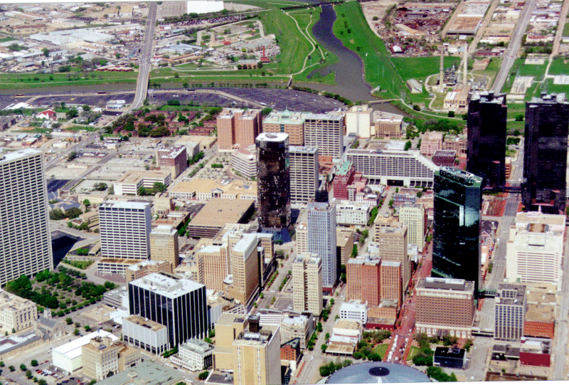
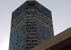
passed through the west side of Fort Worth at about 6:18 p.m. It tore a 4-mile (5-km) path through the city, blowing out windows and causing significant damage to many of the downtown high rise buildings. The tornado dissipated around 6:28 p.m., and at its worst, was approximately one-quarter mile wide (0.4 km). The tornado was classified as a low end F3 on the Fujita scale
Fujita scale
The Fujita scale , or Fujita-Pearson scale, is a scale for rating tornado intensity, based primarily on the damage tornadoes inflict on human-built structures and vegetation...
. Two people were killed by the tornado and 80 were injured, with six seriously injured. The heavy rain and hail that followed damaged many interior areas of buildings which were exposed by the tornado's winds.
The storm system spawned a second tornado which moved through Arlington
Arlington, Texas
Arlington is a city in Tarrant County, Texas within the Dallas–Fort Worth metropolitan area. According to the 2010 census results, the city had a population of 365,438, making it the third largest municipality in the Metroplex...
and Grand Prairie
Grand Prairie, Texas
Grand Prairie is a city in Dallas, Ellis, and Tarrant counties in the U.S. state of Texas and is a part of the Mid-Cities region in the Dallas–Fort Worth metroplex. Grand Prairie is a suburb of both Dallas and Fort Worth and had a population of 175,396 at the 2010 census.- History :The city of...
. The second tornado caused a mile long track of damage mainly through residential areas, leaving 80 people homeless. The storm system caused approximately $500 million in damage to Tarrant County in year 2000 values.
A KXAS outdoor camera in downtown Fort Worth broadcast parts of the tornado coverage on live TV during the 6 p.m. weather segment.
This is not the first time the Dallas/Fort Worth Metroplex
Dallas/Fort Worth Metroplex
The Dallas–Fort Worth–Arlington Metropolitan Statistical Area, a title designated by the U.S. Census as of 2003, encompasses 12 counties within the U.S. state of Texas. The area is divided into two metropolitan divisions: Dallas–Plano–Irving and Fort Worth–Arlington. Residents of the area...
was hit by a significant tornado. Another notable tornado hit Dallas on April 2, 1957. That tornado, which killed 10 people, was among the most photographed tornadoes of the 20th century.
Tornado table
Confirmed tornadoes
| F# Fujita scale The Fujita scale , or Fujita-Pearson scale, is a scale for rating tornado intensity, based primarily on the damage tornadoes inflict on human-built structures and vegetation... |
Location | County | Time (UTC) | Path length | Damage | |
|---|---|---|---|---|---|---|
| Texas Texas Texas is the second largest U.S. state by both area and population, and the largest state by area in the contiguous United States.The name, based on the Caddo word "Tejas" meaning "friends" or "allies", was applied by the Spanish to the Caddo themselves and to the region of their settlement in... |
||||||
| F0 | St. Jo St. Jo, Texas Saint Jo is a city in Montague County, Texas, United States. The population was 977 at the 2000 census.-History:Established in 1856, the city was originally known as Head of Elm, named for its location at the headwaters of the Elm Fork of the Trinity River.... area |
Montague Montague County, Texas As of the census of 2000, there were 19,117 people, 7,770 households, and 5,485 families residing in the county. The population density was 20 people per square mile . There were 9,862 housing units at an average density of 11 per square mile... |
2324 | 0.1 miles (0.16 km) |
A mobile home was damaged | |
| F3 | Fort Worth Fort Worth, Texas Fort Worth is the 16th-largest city in the United States of America and the fifth-largest city in the state of Texas. Located in North Central Texas, just southeast of the Texas Panhandle, the city is a cultural gateway into the American West and covers nearly in Tarrant, Parker, Denton, and... area |
Tarrant Tarrant County, Texas Tarrant County is a county located in the U.S. state of Texas. As of the 2010 U.S. Census, it had a population of 1,809,034. Its county seat is Fort Worth. Tarrant County is the sixteenth most populous county in the United States and the third most populous in Texas. The county is named in honor... |
0018 | 4 miles (6.4 km) |
2 deaths West of downtown Fort Worth, seven buildings collapsed. In the downtown area, eight buildings were destroyed, 27 sustained major damage, and 15 sustained minor damage. This included 17 skyscrapers that were heavily damaged. In total, 15 buildings were destroyed and 62 damaged. 93 homes were destroyed, 203 sustained major damage, and 810 sustained minor damage. Damages were at $450 million damage, inflated to $560.1 million. It is the tenth costliest U.S. tornado. Two people died and 80 were injured, 6 seriously. | |
| F0 | NW of Gainesville Gainesville, Texas Gainesville is a city in and the county seat of Cooke County, Texas, United States. The population was 15,538 at the 2000 census.-History:... |
Cooke Cooke County, Texas As of the census of 2000, there were 36,363 people, 13,643 households, and 10,000 families residing in the county. The population density was 42 people per square mile . There were 15,061 housing units at an average density of 17 per square mile... |
0020 | 0.1 miles (0.16 km) |
Brief touchdown with no damage | |
| F0 | N of Itasca Itasca, Texas Itasca is a city in Hill County in Northern Central Texas. As of the 2000 census, the city population was 1,503.-Geography:Itasca is located at .... |
Hill | 0020 | 0.1 miles (0.16 km) |
Brief touchdown with no damage | |
| F3 | Arlington Arlington, Texas Arlington is a city in Tarrant County, Texas within the Dallas–Fort Worth metropolitan area. According to the 2010 census results, the city had a population of 365,438, making it the third largest municipality in the Metroplex... /Grand Prairie Grand Prairie, Texas Grand Prairie is a city in Dallas, Ellis, and Tarrant counties in the U.S. state of Texas and is a part of the Mid-Cities region in the Dallas–Fort Worth metroplex. Grand Prairie is a suburb of both Dallas and Fort Worth and had a population of 175,396 at the 2010 census.- History :The city of... area |
Tarrant Tarrant County, Texas Tarrant County is a county located in the U.S. state of Texas. As of the 2010 U.S. Census, it had a population of 1,809,034. Its county seat is Fort Worth. Tarrant County is the sixteenth most populous county in the United States and the third most populous in Texas. The county is named in honor... , Dallas Dallas County, Texas As of the census of 2000, there were 2,218,899 people, 807,621 households, and 533,837 families residing in the county. The population density was 2,523 people per square mile . There were 854,119 housing units at an average density of 971/sq mi... |
0105 | 8 miles (12.8 km) |
In Arlington: $27 million damage occurred. The worst damage was at the municipal airport. The Bell Helicopter Textron was damaged as were many helicopters and hangars. A security guard was injured. Northeast of the airport, two subdivisions sustained up to F2 damage. The Health and Human Services Center suffered extensive damage and the Texas Department of Health was destroyed. The Lear Co. and a post office were also damaged. In the city, 6 homes were destroyed, 183 sustained major damage, 185 sustained minor damage, and 704 were affected. 33 businesses and buildings were damaged or destroyed. Over 200 trees were lost. In Grand Prairie: $4,180,000 damage occurred. 296 homes, 256 apartments, and 2 commercial complexes were damaged. This included 61 homes in the Mirabella Neighborhood. Inflations put damage at 38,808,000 (2008 dollars). |
|
| F0 | Leon Valley Leon Valley, Texas Leon Valley is a city in Bexar County, Texas, United States. It is an enclave of San Antonio and is part of the San Antonio-New Braunfels Metropolitan Statistical Area. The population was 9,239 at the 2000 census; the July 1, 2009 Census estimate, however, showed the population had grown to 11,020... /NW San Antonio San Antonio, Texas San Antonio is the seventh-largest city in the United States of America and the second-largest city within the state of Texas, with a population of 1.33 million. Located in the American Southwest and the south–central part of Texas, the city serves as the seat of Bexar County. In 2011,... area |
Bexar Bexar County, Texas As of the census of 2000, there were 1,392,931 people, 488,942 households, and 345,681 families residing in the county. The population density was 1,117 people per square mile . There were 521,359 housing units at an average density of 418 per square mile... |
0111 | 0.1 miles (0.16 km) |
Brief touchdown with no damage | |
| F0 | S of Lancaster Lancaster, Texas Lancaster is a city in Dallas County, Texas, United States. The population was 25,894 at the 2000 census.Lancaster is a suburb of Dallas, Texas and is part of the Best Southwest area, which includes Lancaster, Cedar Hill, DeSoto, and Duncanville. Most of the city is in Dallas County. But a... |
Dallas Dallas County, Texas As of the census of 2000, there were 2,218,899 people, 807,621 households, and 533,837 families residing in the county. The population density was 2,523 people per square mile . There were 854,119 housing units at an average density of 971/sq mi... |
0155 | 0.1 miles (0.16 km) |
Brief touchdown with no damage | |
| F0 | N of Roane | Navarro | 0155 | 0.1 miles (0.16 km) |
Brief touchdown with no damage | |
| F1 | S of Bazette | Navarro | 0215 | 3 miles (4.8 km) |
Three mobile homes and five barns were destroyed while two homes sustained roof damage. | |
| F0 | Trinidad Trinidad, Texas Trinidad is a city in Henderson County, Texas, United States, near the Trinity River from which the town's name was derived. The population was 1,091 at the 2000 census.-Geography:Trinidad is located at .... |
Henderson Henderson County, Texas As of the census of 2000, there were 73,277 people, 28,804 households, and 20,969 families residing in the county. The population density was 84 people per square mile . There were 35,935 housing units at an average density of 41 per square mile... |
0230 | 0.5 miles (0.8 km) |
Minor damage to a few homes | |
| Source: Tornado History Project - March 28, 2000 Storm Data |
||||||
See also
External links
- Preliminary Information on Fort Worth Tornado (National Weather ServiceNational Weather ServiceThe National Weather Service , once known as the Weather Bureau, is one of the six scientific agencies that make up the National Oceanic and Atmospheric Administration of the United States government...
at Fort Worth) - Satellite imagery (University of Wisconsin–MadisonUniversity of Wisconsin–MadisonThe University of Wisconsin–Madison is a public research university located in Madison, Wisconsin, United States. Founded in 1848, UW–Madison is the flagship campus of the University of Wisconsin System. It became a land-grant institution in 1866...
) - Damage Survey and Assessment of Fort Worth Tornado, 28 March 2000
- News Report (USA TodayUSA TodayUSA Today is a national American daily newspaper published by the Gannett Company. It was founded by Al Neuharth. The newspaper vies with The Wall Street Journal for the position of having the widest circulation of any newspaper in the United States, something it previously held since 2003...
) - March 2000 Storm Data report(National Weather ServiceNational Weather ServiceThe National Weather Service , once known as the Weather Bureau, is one of the six scientific agencies that make up the National Oceanic and Atmospheric Administration of the United States government...
at Ft. Worth) - Final Storm Data report (National Climatic Data CenterNational Climatic Data CenterThe United States National Climatic Data Center in Asheville, North Carolina is the world's largest active archive of weather data. The center became established in late 1951, with the move into the new facility occurring in early 1952....
)