

Brandywine Creek
Encyclopedia
Brandywine Creek is a tributary
of the Christina River
in southeastern Pennsylvania
and northern Delaware
in the United States
. The Lower Brandywine (the main stem) is 20.4 miles (32.8 km) long and is a designated Pennsylvania Scenic River
with several tributary streams. The East Branch and West Branch of the creek originate within 2 miles (3 km) of each other on the slopes of Welsh Mountain in Honey Brook Township, Pennsylvania
about 20 miles (32.2 km) northwest of their confluence.
The mouth of the creek on the Christina River
in present-day Wilmington, Delaware
is the site of the New Sweden
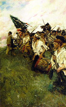
colony, where colonists first landed on March 29, 1638. The Battle of Brandywine
was fought around the creek near Chadds Ford, Pennsylvania, on September 11, 1777, during the American Revolution
. Water powered gristmill
s in Brandywine Village, near the creek mouth, and the nearby DuPont gunpowder mill were important in developing American industry before the introduction of steam power.
and West Branch
of Brandywine Creek, is located in western Chester County, Pennsylvania
, near Honey Brook
. The East Branch and West Branch flow southeast for 27.4 miles (44.1 km) and 33.1 miles (53.3 km), respectively, to their confluence about 10 miles (16.1 km) southeast of Coatesville
, between East Bradford Township
and Pocopson Township
. The combined drainage of the East Branch
and West Branch
, downstream of the confluence, is defined as Brandywine Creek and continues to flow southeast through Chester County, past Chadds Ford
, Delaware County, Pennsylvania
then enters the northern portion of the state of Delaware
approximately 5 miles (8 km) north of Wilmington
.
The creek continues its flow south through Brandywine Creek State Park
, into Wilmington, where it flows through Brandywine Park
near the city center. Brandywine Creek joins the Christina River 1 miles (1.6 km) east of downtown Wilmington and approximately 2 miles (3 km) upstream from the mouth of the Christina, which also includes flows from the White Clay Creek
and Red Clay Creek
basins, and finally discharges into the Delaware River
estuary
. The confluence of the Christina and Delaware rivers is the approximate dividing point between the freshwater Delaware River and the saltwater Delaware Bay
.
In Pennsylvania,Chadds Ford, Elam, Downingtown
, Unionville
, and parts of West Chester
, are all in the Brandywine Valley, as well as the Delaware towns of Centreville, Greenville
, Montchanin
, Hockessin
, and Yorklyn
. Nearby Avondale
(in the White Creek basin) and Kennett Square, Pennsylvania
(in the Red Creek basin) are often considered part of the Brandywine Valley.
-speaking Lenape
(or Delaware) Nation lived in the area between the Hudson River Valley and southern Delaware before the European settlement. They lived by hunting, farming corn, beans, and squash, and by fishing. The Brandywine had an especially rich shad
fishery. The Lenape called the creek Wauwaset, Wawasiungh, or Wawassan, and other Native American names for it included Suspecough and Trancocopanican.
The first European settlement on the Brandywine was Swedish. On March 29, 1638, Peter Minuit
, who had earlier explored the area for the Dutch, founded the colony of New Sweden
near the confluence of the Christina and Brandywine, at Fort Christina
, in present-day Wilmington. About 600 Swedes, Finns, and Dutch settled in New Sweden. They tended to settle along the Delaware River rather than move inland along the Brandywine and are credited with introducing the log cabin
into America. They called the creek Fiskiekylen, or "Fish Creek", and the Dutch heritage is also reflected in Fiske Creek and variant names using the Dutch word "Kill" or stream, Bainwend Kill, Brandewyn Kill, and Brandywine Kill. The creek’s current name may be from an old Dutch word for brandy or gin, brandewijn, or from the name of an early mill owner, Andreas Brainwende or Brantwyn. A 1681 map labels the creek Brande wine Cr. Thomas Holme
's 1687 map of Pennsylvania gives the name as simply Brandy Wine and shows it flowing into Christian Creek and then the Dellaware River.
The Swedes, Dutch and English disputed possession of the area until 1674, when the English gained control. William Penn was granted a charter for Pennsylvania in 1681 and gained control over the "lower three counties," as Delaware was then known, soon thereafter. The population of New Sweden had only reached about 1,000, on the western shore of the Delaware, by the time of Penn's arrival. By 1687, a Swedish colonist, Tyman Stidham, opened the first mill on the Brandywine, near Wilmington. Holme's 1687 map shows only five land claims along the Brandywine, all near present-day Chadds Ford. Land claims of the earlier Swedish and Dutch colonists were not noted on this map.
While the Lenape still remained along the Brandywine, they had by this time been decimated by European diseases and wars with Susquehannock
and later Iroquois
tribes over control of the fur trade
with Europeans. Their estimated population had fallen from 10,000–20,000 in 1600 to 2,000 in 1682. The Lenape signed a series of treaties with the Europeans, beginning with a 1682 treaty with William Penn, but were forced out of eastern Pennsylvania by the time of the French and Indian War
. During the 1720s and 1730s, the Lenape claimed that William Penn had granted them all the land 1 mile on each side of the creek, and complained that mill dams on the creek were ruining their shad fishery.
Hannah Freeman (1730–1802), known as Indian Hannah, is believed to be the last Lenape to have lived in Chester County and is buried in Embreeville, near the forks of the creek.
 The valley was settled by Quakers, and other dissident Protestants, following Penn’s Charter. Their activities were mainly farming and milling. Quaker influence is still felt with over 16 Quaker Meetings and several Quaker schools operating in the area.
The Quaker millers near the mouth of the Brandywine cooperated in maintaining quality and branding the flour. "Brandywine Superfine" flour was shipped all along the Atlantic coast and to the West Indies even before the American Revolution.
A base point for surveying the Mason-Dixon line
, known as the Stargazers’ Stone, was established in Embreeville 31 miles (49.9 km) west of Philadelphia and 15 miles (24.1 km) north of the Maryland-Pennsylvania border by Charles Mason
and Jeremiah Dixon
in 1764. They used the adjoining John Harlan house as their center of operations until 1768.
The creek lends its name to the 1777 Battle of Brandywine
of the American Revolutionary War
. General William Howe
, commanding the British forces, was marching north on Baltimore Pike
(now U.S. Route 1
) toward Philadelphia and needed to ford the Brandywine near Chadds Ford. General George Washington
, massed most of his American forces on the banks of the creek near Chadds Ford, and protected other fords as far as 5 miles (8 km) north and 3 miles (4.8 km) south. The Brandywine Battlefield Park covers only 50 acres (202,343 m²), but during the battle British troops marched about 6 miles (9.7 km) north, fording the creek above the forks, to outflank Washington's forces.
Before the battle, General Anthony Wayne
had his headquarters in Brandywine Village, across the creek from Wilmington, and Continental troops camped nearby, near Lovering Avenue.
Early paper mills were located along the creek, during the Revolution. They supplied Benjamin Franklin
's print shop and also supplied the paper to print Continental currency and the Declaration of Independence
.
The Conestoga wagon
, which later became known as the "prairie schooner" was first built to haul grain from the Conestoga Valley
to Brandywine flour mills.
A group of painters, including N.C. Wyeth, Andrew Wyeth
, Jamie Wyeth
and Howard Pyle
, are referred to as the "Brandywine School
" especially for their landscape works which depict the Brandywine valley. Many of their works are on view at the Brandywine River Museum
in Chadds Ford.
just north of Wilmington. The elevation falls from about 160 feet (48.8 m) above sea level in Chadds Ford, to just a few feet above sea level in Wilmington. The steep descent provided waterpower to many early industrial activities, including flour milling and the original DuPont
gunpowder
mills. The nearness of the fall line along the Brandywine to the Delaware river and Delaware Bay
, allowed manufacturers to use high powered machinery before the use of the steam engine, and to load ocean-going ships from the same location.
By 1687, a Swedish colonist, Tyman Stidham opened the first mill on the Brandywine, near Wilmington. About 1735, Brandywine Village was founded across the creek from Wilmington. Quakers Elizabeth Levis Shipley, her husband William Shipley,
and Thomas Canby were important in establishing the village and its supporting flour mills. By 1743 Thomas's son, Oliver Canby owned 3 mill sites. A dam and a millrace south of the creek had been built.
Prominent Quaker millers, including the Canbys, Leas, and Tatnalls, built their stone homes along Market Street, and the built the Brandywine Academy building in 1798. A cupola was added to the academy in 1820, and it rang as the Marquis de Lafayette visited on October 6, 1824. By 1806 there were "about fifty or sixty snug brick, stone, and frame houses" in the village and about 12 mills.
In 1760 a bridge was built at the current site of the Market Street Bridge, and the north race and two more flour mills were built by Joseph Tatnall.
Oliver Evans
in the 1780s helped local mills increase their efficiency, ushering in the industrial revolution
. His first design for a fully integrated automatic flour mill was built on nearby Red Clay Creek
in 1783, and gradually gained acceptance from Brandywine millers. The grain was unloaded on the ground floor and raised to the top floor by waterpower. Gravity moved the grain through the stages of cleaning, drying, grinding, spreading, and cooling, in a continuous manufacturing process.
The first paper mill
in Delaware, Gilpin's mill in north Wilmington, opened 1787. This site was later used by one of the largest textile mills in the world, Bancroft Mills
which is now closed.
 In 1795, Jacob Broom
built the first cotton mill on the Brandywine, a few miles north of the village.
The mill burned down in 1797, and in 1802 he sold the site, complete with a working dam
and millrace to Eleuthère Irénée du Pont
, who paid $6,740 for the 95 acres (384,451.7 m²). Gunpowder mills, known as the Eleutherian Mills
operated on the site from 1802 until 1921, and by 1810 the site was the largest gunpowder producer in the country. During the Civil War
alone over 4 million barrels of gunpowder were produced here. The mills may be viewed now at the Hagley Museum and Library
. The creek is located at the midpoint of the DuPont Historic Corridor
.
In 1796, the village contained twelve mills with a capacity for grinding 400,000 bushels of grain per year. By 1815 several toll roads connected the village with Pennsylvania's grain growing regions, including the Lancaster, Kennett and Concord Pikes. These roads later became Delaware Route 41
, Delaware Route 52
, and parts of US 202
combined with Delaware Route 202
.
 The millers cooperated in maintaining quality and branding the flour. "Brandywine Superfine" flour was shipped all along the Atlantic coast and to the West Indies before the American Revolution.
A mill race
once used to provide water power is still in working condition in Brandywine Park near downtown Wilmington. This park was designed in the 1890s by Frederick Law Olmsted
.
To the north, Downingtown on the east branch was originally known as Milltown. Its first building, the Downingtown Log House, was built about 1700 where the road between Philadelphia and Lancaster, later known as the Lancaster Pike, crossed the east branch. Thomas Moore built a grist mill in 1716 and Roger Hunt built another in 1739, which operated through at least 1908. Both the Downingtown Log House and the Roger Hunt Mill still stand today.
Milltown was the halfway point on the journey between Philadelphia and Lancaster so several inns served travelers, including the Ship Inn (c. 1730), the King-in-Armes or Washington Inn (1761), the Half-Way House (1790), and the Swan Hotel (1800). In the 1880s Downingtown became known for its paper mills.
Coatesville on the west branch became famous for producing iron goods as early as 1810 and rolling steel plate.
Lukens Steel Company
has dominated economy of the town since 1810, with Mittal
continuing steel production to the present day.
:
Tributary
A tributary or affluent is a stream or river that flows into a main stem river or a lake. A tributary does not flow directly into a sea or ocean...
of the Christina River
Christina River
The Christina River is a tributary of the Delaware River, approximately 35 miles long, in northern Delaware in the United States, also flowing through small areas of southeastern Pennsylvania and northeastern Maryland. Near its mouth the river flows past downtown Wilmington, Delaware,...
in southeastern Pennsylvania
Pennsylvania
The Commonwealth of Pennsylvania is a U.S. state that is located in the Northeastern and Mid-Atlantic regions of the United States. The state borders Delaware and Maryland to the south, West Virginia to the southwest, Ohio to the west, New York and Ontario, Canada, to the north, and New Jersey to...
and northern Delaware
Delaware
Delaware is a U.S. state located on the Atlantic Coast in the Mid-Atlantic region of the United States. It is bordered to the south and west by Maryland, and to the north by Pennsylvania...
in the United States
United States
The United States of America is a federal constitutional republic comprising fifty states and a federal district...
. The Lower Brandywine (the main stem) is 20.4 miles (32.8 km) long and is a designated Pennsylvania Scenic River
Pennsylvania Scenic Rivers
Pennsylvania Scenic Rivers are rivers that are designated "scenic" according to the criteria of the Pennsylvania Scenic Rivers Act . The scenic rivers are managed by a variety of State agencies and local conservancies...
with several tributary streams. The East Branch and West Branch of the creek originate within 2 miles (3 km) of each other on the slopes of Welsh Mountain in Honey Brook Township, Pennsylvania
Honey Brook Township, Pennsylvania
Honey Brook Township is a township in Chester County, Pennsylvania, United States. The population was 7,647 at the 2010 census.-Geography:According to the United States Census Bureau, the township has a total area of , of which is land and , or 1.14%, is water.-Demographics:As of the census of...
about 20 miles (32.2 km) northwest of their confluence.
The mouth of the creek on the Christina River
Christina River
The Christina River is a tributary of the Delaware River, approximately 35 miles long, in northern Delaware in the United States, also flowing through small areas of southeastern Pennsylvania and northeastern Maryland. Near its mouth the river flows past downtown Wilmington, Delaware,...
in present-day Wilmington, Delaware
Wilmington, Delaware
Wilmington is the largest city in the state of Delaware, United States, and is located at the confluence of the Christina River and Brandywine Creek, near where the Christina flows into the Delaware River. It is the county seat of New Castle County and one of the major cities in the Delaware Valley...
is the site of the New Sweden
New Sweden
New Sweden was a Swedish colony along the Delaware River on the Mid-Atlantic coast of North America from 1638 to 1655. Fort Christina, now in Wilmington, Delaware, was the first settlement. New Sweden included parts of the present-day American states of Delaware, New Jersey, and Pennsylvania....
colony, where colonists first landed on March 29, 1638. The Battle of Brandywine
Battle of Brandywine
The Battle of Brandywine, also known as the Battle of the Brandywine or the Battle of Brandywine Creek, was fought between the American army of Major General George Washington and the British-Hessian army of General Sir William Howe on September 11, 1777. The British defeated the Americans and...
was fought around the creek near Chadds Ford, Pennsylvania, on September 11, 1777, during the American Revolution
American Revolution
The American Revolution was the political upheaval during the last half of the 18th century in which thirteen colonies in North America joined together to break free from the British Empire, combining to become the United States of America...
. Water powered gristmill
Gristmill
The terms gristmill or grist mill can refer either to a building in which grain is ground into flour, or to the grinding mechanism itself.- Early history :...
s in Brandywine Village, near the creek mouth, and the nearby DuPont gunpowder mill were important in developing American industry before the introduction of steam power.
Course
The headwater region, for both the East BranchEast Branch Brandywine Creek
The East Branch Brandywine Creek is a tributary of Brandywine Creek in Chester County, Pennsylvania in the United States.-Course:The creek starts in Suplee near Honey Brook, and joins the West Branch Brandywine Creek in Lenape. From its source, the creek flows east, then southeast, passing through...
and West Branch
West Branch Brandywine Creek
The West Branch Brandywine Creek is a tributary of Brandywine Creek in Chester County, Pennsylvania in the United States.The West Branch Brandywine Creek is born near the community of Honey Brook. It later joins with the East Branch Brandywine Creek in the community of Lenape to form Brandywine...
of Brandywine Creek, is located in western Chester County, Pennsylvania
Chester County, Pennsylvania
-State parks:*French Creek State Park*Marsh Creek State Park*White Clay Creek Preserve-Demographics:As of the 2010 census, the county was 85.5% White, 6.1% Black or African American, 0.2% Native American or Alaskan Native, 3.9% Asian, 0.0% Native Hawaiian, 1.8% were two or more races, and 2.4% were...
, near Honey Brook
Honey Brook Township, Pennsylvania
Honey Brook Township is a township in Chester County, Pennsylvania, United States. The population was 7,647 at the 2010 census.-Geography:According to the United States Census Bureau, the township has a total area of , of which is land and , or 1.14%, is water.-Demographics:As of the census of...
. The East Branch and West Branch flow southeast for 27.4 miles (44.1 km) and 33.1 miles (53.3 km), respectively, to their confluence about 10 miles (16.1 km) southeast of Coatesville
Coatesville, Pennsylvania
Coatesville is the only city in Chester County, Pennsylvania, United States. The population was 13,100 at the 2010 census. Coatesville is approximately 39 miles west of Philadelphia....
, between East Bradford Township
East Bradford Township, Pennsylvania
East Bradford Township is a township in Chester County, Pennsylvania, United States. The population was 9,942 at the 2010 census.-Geography:...
and Pocopson Township
Pocopson Township, Pennsylvania
Pocopson Township is a township in Chester County, Pennsylvania, United States. The population was 4,582 at the 2010 census.-Geography:According to the United States Census Bureau, the township has a total area of , of which is land and , or 1.43%, is water.-Demographics:As of the census of 2000,...
. The combined drainage of the East Branch
East Branch Brandywine Creek
The East Branch Brandywine Creek is a tributary of Brandywine Creek in Chester County, Pennsylvania in the United States.-Course:The creek starts in Suplee near Honey Brook, and joins the West Branch Brandywine Creek in Lenape. From its source, the creek flows east, then southeast, passing through...
and West Branch
West Branch Brandywine Creek
The West Branch Brandywine Creek is a tributary of Brandywine Creek in Chester County, Pennsylvania in the United States.The West Branch Brandywine Creek is born near the community of Honey Brook. It later joins with the East Branch Brandywine Creek in the community of Lenape to form Brandywine...
, downstream of the confluence, is defined as Brandywine Creek and continues to flow southeast through Chester County, past Chadds Ford
Chadds Ford Township, Pennsylvania
Chadds Ford Township is a township in Delaware County, Pennsylvania, United States, about 30 miles southwest of Philadelphia. Prior to 1996, Chadds Ford Township was known as Birmingham Township, Delaware County, and the name was changed to allow the township to correspond to both its...
, Delaware County, Pennsylvania
Delaware County, Pennsylvania
Delaware County is a county located in the U.S. state of Pennsylvania. As of 2010, the population was 558,979, making it Pennsylvania's fifth most populous county, behind Philadelphia, Allegheny, Montgomery, and Bucks counties....
then enters the northern portion of the state of Delaware
Delaware
Delaware is a U.S. state located on the Atlantic Coast in the Mid-Atlantic region of the United States. It is bordered to the south and west by Maryland, and to the north by Pennsylvania...
approximately 5 miles (8 km) north of Wilmington
Wilmington, Delaware
Wilmington is the largest city in the state of Delaware, United States, and is located at the confluence of the Christina River and Brandywine Creek, near where the Christina flows into the Delaware River. It is the county seat of New Castle County and one of the major cities in the Delaware Valley...
.
The creek continues its flow south through Brandywine Creek State Park
Brandywine Creek State Park
Brandywine Creek State Park is a state park, located north of Wilmington, Delaware along the Brandywine Creek. Open year-round, it is in area and, before becoming a state park in 1965, was a dairy farm owned by the Du Pont family. It contains the first two nature preserves in Delaware. These...
, into Wilmington, where it flows through Brandywine Park
Wilmington State Parks
The Wilmington State Parks are a group of four parks in Wilmington, New Castle County, Delaware in the United States. The four parks are Brandywine Park, including the Brandywine Zoo and Baynard Stadium, Alapocas Woods Natural Area, H. Fletcher Brown Park and Rockford Park. Admission to the parks...
near the city center. Brandywine Creek joins the Christina River 1 miles (1.6 km) east of downtown Wilmington and approximately 2 miles (3 km) upstream from the mouth of the Christina, which also includes flows from the White Clay Creek
White Clay Creek
White Clay Creek is an tributary of the Christina River in southern Pennsylvania and northern Delaware in the United States. It is renowned for its scenic character and is largely federally protected....
and Red Clay Creek
Red Clay Creek
Red Clay Creek is a tributary of White Clay Creek in southeastern Pennsylvania and northern Delaware in the United States.The East and West branches both rise in West Marlborough Township, Pennsylvania, near the hamlet of Upland, and flow south through Kennett Square before uniting just north of...
basins, and finally discharges into the Delaware River
Delaware River
The Delaware River is a major river on the Atlantic coast of the United States.A Dutch expedition led by Henry Hudson in 1609 first mapped the river. The river was christened the South River in the New Netherland colony that followed, in contrast to the North River, as the Hudson River was then...
estuary
Estuary
An estuary is a partly enclosed coastal body of water with one or more rivers or streams flowing into it, and with a free connection to the open sea....
. The confluence of the Christina and Delaware rivers is the approximate dividing point between the freshwater Delaware River and the saltwater Delaware Bay
Delaware Bay
Delaware Bay is a major estuary outlet of the Delaware River on the Northeast seaboard of the United States whose fresh water mixes for many miles with the waters of the Atlantic Ocean. It is in area. The bay is bordered by the State of New Jersey and the State of Delaware...
.
In Pennsylvania,Chadds Ford, Elam, Downingtown
Downingtown, Pennsylvania
Downingtown is a borough in Chester County, Pennsylvania, west of Philadelphia. As of the 2010 census it had a population of 7,891. Downingtown was settled by English and European colonists in the early 18th century and has a number of historic buildings and structures.-History:The town was...
, Unionville
Unionville, Chester County, Pennsylvania
Unionville is an unincorporated community in East Marlborough Township in southern Chester County, Pennsylvania, United States. It was originally known as "Jacksonville."-Education:...
, and parts of West Chester
West Chester, Pennsylvania
The Borough of West Chester is the county seat of Chester County, Pennsylvania, United States. The population was 18,461 at the 2010 census.Valley Forge, the Brandywine Battlefield, Longwood Gardens, Marsh Creek State Park, and other historical attractions are near West Chester...
, are all in the Brandywine Valley, as well as the Delaware towns of Centreville, Greenville
Greenville, Delaware
Greenville is a census-designated place in New Castle County, Delaware, United States. The population was 2,326 at the 2010 census.-Geography:Greenville is located at ....
, Montchanin
Montchanin, Delaware
Montchanin is an unincorporated community in New Castle County, Delaware, United States. The community was named for Anne Alexandrine de Montchanin, mother of Pierre Samuel du Pont de Nemours. The Jacob Broom House, a National Historic Landmark, is located there....
, Hockessin
Hockessin, Delaware
Hockessin is a census-designated place in New Castle County, Delaware, United States. The population was 12,902 at the 2000 census. The place name may be derived from the Lenape word "hòkèsa" meaning "pieces of bark" or from a misspelling of "occasion," as pronounced by the Quakers who settled...
, and Yorklyn
Yorklyn, Delaware
Yorklyn is an unincorporated community in northern New Castle County, Delaware, United States. It lies along Delaware Route 82 northwest of the city of Wilmington, the county seat of New Castle County. Its elevation is 174 feet...
. Nearby Avondale
Avondale, Pennsylvania
Avondale is a borough in Chester County, Pennsylvania, United States. The population was 1,265 at the 2010 census.-Geography:Avondale is located at ....
(in the White Creek basin) and Kennett Square, Pennsylvania
Kennett Square, Pennsylvania
Kennett Square is a borough in Chester County, Pennsylvania, United States. It is known as the Mushroom Capital of the World because mushroom farming in the region produces over a million pounds of mushrooms a year...
(in the Red Creek basin) are often considered part of the Brandywine Valley.
History
Native Americans of the AlgonquianAlgonquian languages
The Algonquian languages also Algonkian) are a subfamily of Native American languages which includes most of the languages in the Algic language family. The name of the Algonquian language family is distinguished from the orthographically similar Algonquin dialect of the Ojibwe language, which is a...
-speaking Lenape
Lenape
The Lenape are an Algonquian group of Native Americans of the Northeastern Woodlands. They are also called Delaware Indians. As a result of the American Revolutionary War and later Indian removals from the eastern United States, today the main groups live in Canada, where they are enrolled in the...
(or Delaware) Nation lived in the area between the Hudson River Valley and southern Delaware before the European settlement. They lived by hunting, farming corn, beans, and squash, and by fishing. The Brandywine had an especially rich shad
Shad
The shads or river herrings comprise the genus Alosa, fish related to herring in the family Clupeidae. They are distinct from others in that family by having a deeper body and spawning in rivers. The several species frequent different areas on both sides of the Atlantic Ocean, Mediterranean Sea....
fishery. The Lenape called the creek Wauwaset, Wawasiungh, or Wawassan, and other Native American names for it included Suspecough and Trancocopanican.
The first European settlement on the Brandywine was Swedish. On March 29, 1638, Peter Minuit
Peter Minuit
Peter Minuit, Pieter Minuit, Pierre Minuit or Peter Minnewit was a Walloon from Wesel, in present-day North Rhine-Westphalia, Germany, then part of the Duchy of Cleves. He was the Director-General of the Dutch colony of New Netherland from 1626 until 1633, and he founded the Swedish colony of...
, who had earlier explored the area for the Dutch, founded the colony of New Sweden
New Sweden
New Sweden was a Swedish colony along the Delaware River on the Mid-Atlantic coast of North America from 1638 to 1655. Fort Christina, now in Wilmington, Delaware, was the first settlement. New Sweden included parts of the present-day American states of Delaware, New Jersey, and Pennsylvania....
near the confluence of the Christina and Brandywine, at Fort Christina
Fort Christina
Fort Christina was the first Swedish settlement in North America and the principal settlement of the New Sweden colony...
, in present-day Wilmington. About 600 Swedes, Finns, and Dutch settled in New Sweden. They tended to settle along the Delaware River rather than move inland along the Brandywine and are credited with introducing the log cabin
Log cabin
A log cabin is a house built from logs. It is a fairly simple type of log house. A distinction should be drawn between the traditional meanings of "log cabin" and "log house." Historically most "Log cabins" were a simple one- or 1½-story structures, somewhat impermanent, and less finished or less...
into America. They called the creek Fiskiekylen, or "Fish Creek", and the Dutch heritage is also reflected in Fiske Creek and variant names using the Dutch word "Kill" or stream, Bainwend Kill, Brandewyn Kill, and Brandywine Kill. The creek’s current name may be from an old Dutch word for brandy or gin, brandewijn, or from the name of an early mill owner, Andreas Brainwende or Brantwyn. A 1681 map labels the creek Brande wine Cr. Thomas Holme
Thomas Holme
Thomas Holme was the first Surveyor General of Pennsylvania to actually serve, in which capacity he laid out the original plan for the city of Philadelphia.-Life:...
's 1687 map of Pennsylvania gives the name as simply Brandy Wine and shows it flowing into Christian Creek and then the Dellaware River.
The Swedes, Dutch and English disputed possession of the area until 1674, when the English gained control. William Penn was granted a charter for Pennsylvania in 1681 and gained control over the "lower three counties," as Delaware was then known, soon thereafter. The population of New Sweden had only reached about 1,000, on the western shore of the Delaware, by the time of Penn's arrival. By 1687, a Swedish colonist, Tyman Stidham, opened the first mill on the Brandywine, near Wilmington. Holme's 1687 map shows only five land claims along the Brandywine, all near present-day Chadds Ford. Land claims of the earlier Swedish and Dutch colonists were not noted on this map.
While the Lenape still remained along the Brandywine, they had by this time been decimated by European diseases and wars with Susquehannock
Susquehannock
The Susquehannock people were Iroquoian-speaking Native Americans who lived in areas adjacent to the Susquehanna River and its tributaries from the southern part of what is now New York, through Pennsylvania, to the mouth of the Susquehanna in Maryland at the north end of the Chesapeake Bay...
and later Iroquois
Iroquois
The Iroquois , also known as the Haudenosaunee or the "People of the Longhouse", are an association of several tribes of indigenous people of North America...
tribes over control of the fur trade
Fur trade
The fur trade is a worldwide industry dealing in the acquisition and sale of animal fur. Since the establishment of world market for in the early modern period furs of boreal, polar and cold temperate mammalian animals have been the most valued...
with Europeans. Their estimated population had fallen from 10,000–20,000 in 1600 to 2,000 in 1682. The Lenape signed a series of treaties with the Europeans, beginning with a 1682 treaty with William Penn, but were forced out of eastern Pennsylvania by the time of the French and Indian War
French and Indian War
The French and Indian War is the common American name for the war between Great Britain and France in North America from 1754 to 1763. In 1756, the war erupted into the world-wide conflict known as the Seven Years' War and thus came to be regarded as the North American theater of that war...
. During the 1720s and 1730s, the Lenape claimed that William Penn had granted them all the land 1 mile on each side of the creek, and complained that mill dams on the creek were ruining their shad fishery.
Hannah Freeman (1730–1802), known as Indian Hannah, is believed to be the last Lenape to have lived in Chester County and is buried in Embreeville, near the forks of the creek.
The Quaker millers near the mouth of the Brandywine cooperated in maintaining quality and branding the flour. "Brandywine Superfine" flour was shipped all along the Atlantic coast and to the West Indies even before the American Revolution.
A base point for surveying the Mason-Dixon line
Mason-Dixon line
The Mason–Dixon Line was surveyed between 1763 and 1767 by Charles Mason and Jeremiah Dixon in the resolution of a border dispute between British colonies in Colonial America. It forms a demarcation line among four U.S. states, forming part of the borders of Pennsylvania, Maryland, Delaware, and...
, known as the Stargazers’ Stone, was established in Embreeville 31 miles (49.9 km) west of Philadelphia and 15 miles (24.1 km) north of the Maryland-Pennsylvania border by Charles Mason
Charles Mason
Charles Mason was an English astronomer who made significant contributions to 18th-century science and American history, particularly through his involvement with the survey of the Mason-Dixon line, which came to mark the division between the northern and southern United States...
and Jeremiah Dixon
Jeremiah Dixon
Jeremiah Dixon was an English surveyor and astronomer who is perhaps best known for his work with Charles Mason, from 1763 to 1767, in determining what was later called the Mason-Dixon line....
in 1764. They used the adjoining John Harlan house as their center of operations until 1768.
The creek lends its name to the 1777 Battle of Brandywine
Battle of Brandywine
The Battle of Brandywine, also known as the Battle of the Brandywine or the Battle of Brandywine Creek, was fought between the American army of Major General George Washington and the British-Hessian army of General Sir William Howe on September 11, 1777. The British defeated the Americans and...
of the American Revolutionary War
American Revolutionary War
The American Revolutionary War , the American War of Independence, or simply the Revolutionary War, began as a war between the Kingdom of Great Britain and thirteen British colonies in North America, and ended in a global war between several European great powers.The war was the result of the...
. General William Howe
William Howe, 5th Viscount Howe
William Howe, 5th Viscount Howe, KB, PC was a British army officer who rose to become Commander-in-Chief of British forces during the American War of Independence...
, commanding the British forces, was marching north on Baltimore Pike
Baltimore Pike
thumb|[[SEPTA]]'s [[SEPTA Route 34|Route 34]] streetcar line runs through the 4500 block of Baltimore Avenue in [[West Philadelphia]]The Baltimore Pike was an auto trail in the United States, connecting Baltimore, Maryland with Philadelphia, Pennsylvania....
(now U.S. Route 1
U.S. Route 1
U.S. Route 1 is a major north–south U.S. Highway that serves the East Coast of the United States. It runs 2,377 miles from Fort Kent, Maine at the Canadian border south to Key West, Florida. U.S. 1 generally parallels Interstate 95, though it is significantly farther west between...
) toward Philadelphia and needed to ford the Brandywine near Chadds Ford. General George Washington
George Washington
George Washington was the dominant military and political leader of the new United States of America from 1775 to 1799. He led the American victory over Great Britain in the American Revolutionary War as commander-in-chief of the Continental Army from 1775 to 1783, and presided over the writing of...
, massed most of his American forces on the banks of the creek near Chadds Ford, and protected other fords as far as 5 miles (8 km) north and 3 miles (4.8 km) south. The Brandywine Battlefield Park covers only 50 acres (202,343 m²), but during the battle British troops marched about 6 miles (9.7 km) north, fording the creek above the forks, to outflank Washington's forces.
Before the battle, General Anthony Wayne
Anthony Wayne
Anthony Wayne was a United States Army general and statesman. Wayne adopted a military career at the outset of the American Revolutionary War, where his military exploits and fiery personality quickly earned him a promotion to the rank of brigadier general and the sobriquet of Mad Anthony.-Early...
had his headquarters in Brandywine Village, across the creek from Wilmington, and Continental troops camped nearby, near Lovering Avenue.
Early paper mills were located along the creek, during the Revolution. They supplied Benjamin Franklin
Benjamin Franklin
Dr. Benjamin Franklin was one of the Founding Fathers of the United States. A noted polymath, Franklin was a leading author, printer, political theorist, politician, postmaster, scientist, musician, inventor, satirist, civic activist, statesman, and diplomat...
's print shop and also supplied the paper to print Continental currency and the Declaration of Independence
United States Declaration of Independence
The Declaration of Independence was a statement adopted by the Continental Congress on July 4, 1776, which announced that the thirteen American colonies then at war with Great Britain regarded themselves as independent states, and no longer a part of the British Empire. John Adams put forth a...
.
The Conestoga wagon
Conestoga wagon
The Conestoga wagon is a heavy, broad-wheeled covered wagon that was used extensively during the late 18th century and the 19th century in the United States and sometimes in Canada as well. It was large enough to transport loads up to 8 tons , and was drawn by horses, mules or oxen...
, which later became known as the "prairie schooner" was first built to haul grain from the Conestoga Valley
Conestoga River
The Conestoga River, also referred to as Conestoga Creek, is a tributary of the Susquehanna River flowing through the center of Lancaster County, Pennsylvania.-Geography:...
to Brandywine flour mills.
A group of painters, including N.C. Wyeth, Andrew Wyeth
Andrew Wyeth
Andrew Newell Wyeth was a visual artist, primarily a realist painter, working predominantly in a regionalist style. He was one of the best-known U.S. artists of the middle 20th century....
, Jamie Wyeth
Jamie Wyeth
James Browning Wyeth is a contemporary American realist painter. He was raised in Chadds Ford Township, Pennsylvania, son of Andrew Wyeth and grandson of N.C. Wyeth...
and Howard Pyle
Howard Pyle
Howard Pyle was an American illustrator and author, primarily of books for young people. A native of Wilmington, Delaware, he spent the last year of his life in Florence, Italy.__FORCETOC__...
, are referred to as the "Brandywine School
Brandywine School
The Brandywine School was a style of illustration and an artists colony in Chadds Ford, Pennsylvania, near Brandywine Creek, founded by artist Howard Pyle at the end of the 19th century...
" especially for their landscape works which depict the Brandywine valley. Many of their works are on view at the Brandywine River Museum
Brandywine River Museum
The Brandywine River Museum is a museum of regional and American art located on U.S. Route 1 in Chadds Ford, Pennsylvania on the banks of the Brandywine River. The museum showcases the art of Andrew Wyeth a major American realist painter, and his family: his father, N.C...
in Chadds Ford.
Brandywine Village and early industrialization
The Brandywine crosses the fall lineFall line
A fall line is a geomorphologic unconformity between an upland region of relatively hard crystalline basement rock and a coastal plain of softer sedimentary rock. A fall line is typically prominent when crossed by a river, for there will often be rapids or waterfalls...
just north of Wilmington. The elevation falls from about 160 feet (48.8 m) above sea level in Chadds Ford, to just a few feet above sea level in Wilmington. The steep descent provided waterpower to many early industrial activities, including flour milling and the original DuPont
DuPont
E. I. du Pont de Nemours and Company , commonly referred to as DuPont, is an American chemical company that was founded in July 1802 as a gunpowder mill by Eleuthère Irénée du Pont. DuPont was the world's third largest chemical company based on market capitalization and ninth based on revenue in 2009...
gunpowder
Gunpowder
Gunpowder, also known since in the late 19th century as black powder, was the first chemical explosive and the only one known until the mid 1800s. It is a mixture of sulfur, charcoal, and potassium nitrate - with the sulfur and charcoal acting as fuels, while the saltpeter works as an oxidizer...
mills. The nearness of the fall line along the Brandywine to the Delaware river and Delaware Bay
Delaware Bay
Delaware Bay is a major estuary outlet of the Delaware River on the Northeast seaboard of the United States whose fresh water mixes for many miles with the waters of the Atlantic Ocean. It is in area. The bay is bordered by the State of New Jersey and the State of Delaware...
, allowed manufacturers to use high powered machinery before the use of the steam engine, and to load ocean-going ships from the same location.
By 1687, a Swedish colonist, Tyman Stidham opened the first mill on the Brandywine, near Wilmington. About 1735, Brandywine Village was founded across the creek from Wilmington. Quakers Elizabeth Levis Shipley, her husband William Shipley,
and Thomas Canby were important in establishing the village and its supporting flour mills. By 1743 Thomas's son, Oliver Canby owned 3 mill sites. A dam and a millrace south of the creek had been built.
Prominent Quaker millers, including the Canbys, Leas, and Tatnalls, built their stone homes along Market Street, and the built the Brandywine Academy building in 1798. A cupola was added to the academy in 1820, and it rang as the Marquis de Lafayette visited on October 6, 1824. By 1806 there were "about fifty or sixty snug brick, stone, and frame houses" in the village and about 12 mills.
In 1760 a bridge was built at the current site of the Market Street Bridge, and the north race and two more flour mills were built by Joseph Tatnall.
Oliver Evans
Oliver Evans
Oliver Evans was an American inventor. Evans was born in Newport, Delaware to a family of Welsh settlers. At the age of 14 he was apprenticed to a wheelwright....
in the 1780s helped local mills increase their efficiency, ushering in the industrial revolution
Industrial Revolution
The Industrial Revolution was a period from the 18th to the 19th century where major changes in agriculture, manufacturing, mining, transportation, and technology had a profound effect on the social, economic and cultural conditions of the times...
. His first design for a fully integrated automatic flour mill was built on nearby Red Clay Creek
Red Clay Creek
Red Clay Creek is a tributary of White Clay Creek in southeastern Pennsylvania and northern Delaware in the United States.The East and West branches both rise in West Marlborough Township, Pennsylvania, near the hamlet of Upland, and flow south through Kennett Square before uniting just north of...
in 1783, and gradually gained acceptance from Brandywine millers. The grain was unloaded on the ground floor and raised to the top floor by waterpower. Gravity moved the grain through the stages of cleaning, drying, grinding, spreading, and cooling, in a continuous manufacturing process.
The first paper mill
Paper mill
A paper mill is a factory devoted to making paper from vegetable fibres such as wood pulp, old rags and other ingredients using a Fourdrinier machine or other type of paper machine.- History :...
in Delaware, Gilpin's mill in north Wilmington, opened 1787. This site was later used by one of the largest textile mills in the world, Bancroft Mills
Bancroft Mills
Bancroft Mills is an abandoned mill complex along Brandywine Creek in Wilmington, Delaware, United States. It has been the site of some of the earliest and most famous mills near Wilmington and was the largest and longest running complex along the Brandywine....
which is now closed.
Jacob Broom
Jacob Broom was an American businessman and politician from Wilmington, in New Castle County, Delaware. As a delegate to the U.S. Constitutional Convention of 1787, he was a signer of the U.S. Constitution. He was also appointed as a delegate to the Annapolis Convention but did not attend, and...
built the first cotton mill on the Brandywine, a few miles north of the village.
The mill burned down in 1797, and in 1802 he sold the site, complete with a working dam
Dam
A dam is a barrier that impounds water or underground streams. Dams generally serve the primary purpose of retaining water, while other structures such as floodgates or levees are used to manage or prevent water flow into specific land regions. Hydropower and pumped-storage hydroelectricity are...
and millrace to Eleuthère Irénée du Pont
Eleuthère Irénée du Pont
Éleuthère Irénée du Pont de Nemours , known as Irénée du Pont, or E.I. du Pont, was a French-born Huguenot chemist and industrialist who immigrated to the United States in 1799 and founded the gunpowder manufacturer, E. I. du Pont de Nemours and Company...
, who paid $6,740 for the 95 acres (384,451.7 m²). Gunpowder mills, known as the Eleutherian Mills
Eleutherian Mills
From 1802 to 1921, Eleutherian Mills was a gunpowder mill site used for the manufacture of explosives by the Du Pont family business. The name also refers to the house on the hill above the mills, which was the first Du Pont family home in America. The business was founded by Eleuthère Irénée du Pont...
operated on the site from 1802 until 1921, and by 1810 the site was the largest gunpowder producer in the country. During the Civil War
American Civil War
The American Civil War was a civil war fought in the United States of America. In response to the election of Abraham Lincoln as President of the United States, 11 southern slave states declared their secession from the United States and formed the Confederate States of America ; the other 25...
alone over 4 million barrels of gunpowder were produced here. The mills may be viewed now at the Hagley Museum and Library
Hagley Museum and Library
The Hagley Museum and Library is a nonprofit educational institution located in Wilmington, Delaware. Hagley Museum and Library collects, preserves and interprets the history of American enterprise.- Hagley Library :...
. The creek is located at the midpoint of the DuPont Historic Corridor
DuPont Historic Corridor
The DuPont Historic Corridor is a section of Delaware Route 141 that traces the history of both the Du Pont family and the DuPont company. The southwest point houses DuPont’s Chestnut Run Plaza and the northeastern end is home to the Alfred I. duPont Hospital for Children...
.
In 1796, the village contained twelve mills with a capacity for grinding 400,000 bushels of grain per year. By 1815 several toll roads connected the village with Pennsylvania's grain growing regions, including the Lancaster, Kennett and Concord Pikes. These roads later became Delaware Route 41
Delaware Route 41
Delaware Route 41 is a highway in northwestern New Castle County. Its northern terminus is the Pennsylvania state line just north of Hockessin, and it continues on as Pennsylvania Route 41 to Gap. Its southern terminus is the on-ramp to Delaware Route 141 southbound...
, Delaware Route 52
Delaware Route 52
Delaware Route 52 is a state highway in New Castle County, Delaware. The route runs from U.S. Route 13 Business in Wilmington, Delaware north to Pennsylvania Route 52 at the Pennsylvania border near Centerville, Delaware. Even though the southern terminus is at US 13 Business, DelDOT has DE 52...
, and parts of US 202
U.S. Route 202 in Delaware
U.S. Route 202 runs through northern New Castle County in the U.S. state of Delaware. It heads from a cloverleaf interchange with U.S. Route 13 and U.S...
combined with Delaware Route 202
Delaware Route 202
Delaware Route 202, also known as Concord Avenue, is a short state highway in Wilmington, Delaware. It runs from Business U.S. Route 13 to a modified cloverleaf interchange with Interstate 95 and U.S. Route 202 at the northern city limits. North of the interchange, the route becomes US 202...
.
A mill race
Mill race
A mill race, raceway or mill lade is the current or channel of a stream, especially one for conducting water to or from a water wheel or other device for utilizing its energy...
once used to provide water power is still in working condition in Brandywine Park near downtown Wilmington. This park was designed in the 1890s by Frederick Law Olmsted
Frederick Law Olmsted
Frederick Law Olmsted was an American journalist, social critic, public administrator, and landscape designer. He is popularly considered to be the father of American landscape architecture, although many scholars have bestowed that title upon Andrew Jackson Downing...
.
To the north, Downingtown on the east branch was originally known as Milltown. Its first building, the Downingtown Log House, was built about 1700 where the road between Philadelphia and Lancaster, later known as the Lancaster Pike, crossed the east branch. Thomas Moore built a grist mill in 1716 and Roger Hunt built another in 1739, which operated through at least 1908. Both the Downingtown Log House and the Roger Hunt Mill still stand today.
Milltown was the halfway point on the journey between Philadelphia and Lancaster so several inns served travelers, including the Ship Inn (c. 1730), the King-in-Armes or Washington Inn (1761), the Half-Way House (1790), and the Swan Hotel (1800). In the 1880s Downingtown became known for its paper mills.
Coatesville on the west branch became famous for producing iron goods as early as 1810 and rolling steel plate.
Lukens Steel Company
Lukens Steel Company
Lukens Steel Company is located in Coatesville, Pennsylvania. Lukens is the oldest steel mill in commission within the United States. In 1995 it was one of the three largest producers of plate steel and the largest domestic manufacturer of alloy-plate. It is ranked fourth out of 24 public steel...
has dominated economy of the town since 1810, with Mittal
Mittal Steel Company
Mittal Steel Company N.V. was one of the world's largest steel producers by volume, and also one of the largests in turnover. The company is now part of ArcelorMittal....
continuing steel production to the present day.
Historic preservation
These places near the Brandywine are on the National Register of Historic PlacesNational Register of Historic Places
The National Register of Historic Places is the United States government's official list of districts, sites, buildings, structures, and objects deemed worthy of preservation...
:
| Site | Address | Listed |
|---|---|---|
| Fort Christina Fort Christina Fort Christina was the first Swedish settlement in North America and the principal settlement of the New Sweden colony... |
E. 7th Street, Wilmington, Delaware Wilmington, Delaware Wilmington is the largest city in the state of Delaware, United States, and is located at the confluence of the Christina River and Brandywine Creek, near where the Christina flows into the Delaware River. It is the county seat of New Castle County and one of the major cities in the Delaware Valley... Near mouth of creek 39°44′14"N 75°32′18"W |
1961, 1966 |
| Old Swedes Church Holy Trinity Church (Old Swedes) Holy Trinity Church, also known as Old Swedes is a church in Wilmington, Delaware that is a National Historic Landmark. It was dedicated on July 4, 1699.-History:... |
E. 7th Street at Church Street 39°44′18"N 75°32′26"W |
1961, 1966 |
| Dr. John A. Brown House | 4 7th Ave 39°44′6"N 75°31′31"W |
1966 |
| Howard High School Howard High School of Technology Howard High School of Technology is a vocational-technical high school in Wilmington, Delaware and is the oldest of four high schools within the New Castle County Vocational-Technical School District, which includes Delcastle Technical High School in Newport, Hodgson Vo-Tech High School in Glasgow,... |
13th Street at Poplar Street 39°44′48"N 75°32′30"W |
1985 |
| Brandywine Village | North and east of Market Street Bridge 39.7518°N 75.5425°W |
1971, 1976 |
| Baynard Boulevard Historic District | Baynard Blvd. between 18th St. and Concord Ave 39.7580°N 75.5446°W |
1979 |
| Brandywine Park Wilmington State Parks The Wilmington State Parks are a group of four parks in Wilmington, New Castle County, Delaware in the United States. The four parks are Brandywine Park, including the Brandywine Zoo and Baynard Stadium, Alapocas Woods Natural Area, H. Fletcher Brown Park and Rockford Park. Admission to the parks... |
North of Market Street Bridge to Augustine Bridge 39.7550°N 75.5500°W |
1976 |
| Old First Presbyterian Church of Wilmington | West Street at Brandywine Park Drive 39.7509°N 75.5479°W |
1972 |
| Continental Army Encampment Site | Lovering Avenue, near Broom Street 39°45′30"N 75°33′21"W |
1972 |
| Augustine Paper Mill | N. Brandywine Park Dr. 39°45′43"N 75°33′25"W |
1978 |
| Bancroft Mills Bancroft Mills Bancroft Mills is an abandoned mill complex along Brandywine Creek in Wilmington, Delaware, United States. It has been the site of some of the earliest and most famous mills near Wilmington and was the largest and longest running complex along the Brandywine.... |
Rockford Road at the Brandywine 39.7685°N 75.5657°W |
1984 |
| Rockford Park Wilmington State Parks The Wilmington State Parks are a group of four parks in Wilmington, New Castle County, Delaware in the United States. The four parks are Brandywine Park, including the Brandywine Zoo and Baynard Stadium, Alapocas Woods Natural Area, H. Fletcher Brown Park and Rockford Park. Admission to the parks... |
West of Rockford Road, south of creek 39.7675°N 75.5716°W |
1978 |
| Brandywine Manufacturers Sunday School | North of Wilmington on Hagley Rd. 39°46′45"N 75°34′34"W |
1972 |
| Eleutherian Mills Eleutherian Mills From 1802 to 1921, Eleutherian Mills was a gunpowder mill site used for the manufacture of explosives by the Du Pont family business. The name also refers to the house on the hill above the mills, which was the first Du Pont family home in America. The business was founded by Eleuthère Irénée du Pont... |
Rt. 141 at Brandywine Creek Bridge 39.7746°N 75.5783°W |
1966 |
| Brandywine Powder Mills District | Rt. 141 at the Brandywine 39°46′48"N 75°34′40"W |
1984 |
| Breck's Mill Area | Breck's Lane and Creek Rd. 39°46′14"N 75°34′56"W |
1971 |
| Rockland Historic District | Rockland, DE 39.7972°N 75.5720°W |
1972 |
| N.C. Wyeth House and Studio | Murphy Rd. near Rt. 100, Chadds Ford, Pennsylvania 39.868°N 75.586°W |
1979 |
| Chadds Ford Historic District | U.S. Route 1 U.S. Route 1 U.S. Route 1 is a major north–south U.S. Highway that serves the East Coast of the United States. It runs 2,377 miles from Fort Kent, Maine at the Canadian border south to Key West, Florida. U.S. 1 generally parallels Interstate 95, though it is significantly farther west between... at PA 100, Chadds Ford, Pennsylvania 39.8719°N 75.5911°W |
1971 |
| Brandywine Battlefield Brandywine Battlefield Brandywine Battlefield Historic Site is a historical park that was operated by the Pennsylvania Historical and Museum Commission, on , near Chadds Ford, Delaware County, Pennsylvania in the United States. It is part of the site of the Battle of Brandywine fought on September 11, 1777, during the... |
U.S. Route 1 U.S. Route 1 U.S. Route 1 is a major north–south U.S. Highway that serves the East Coast of the United States. It runs 2,377 miles from Fort Kent, Maine at the Canadian border south to Key West, Florida. U.S. 1 generally parallels Interstate 95, though it is significantly farther west between... east of Brandywine Creek, Chadds Ford, Pennsylvania 39°52′31"N 75°34′31"W |
1966 |
| Brinton's Mill | PA 100, north of Chadds Ford 39°53′10"N 75°36′30"W |
1971 |
| Lenape Bridge | Rt 52 at Rt 100, Lenape 39.9146°N 75.6301°W |
1982 |
| Gibson's Covered Bridge | East Branch US 322 and Harmony Hill Rd, west of West Chester 39.9760°N 75.6829°W |
1971 |
| Downingtown Log House | 15 E. Lancaster Ave., Downingtown, Pennsylvania Downingtown, Pennsylvania Downingtown is a borough in Chester County, Pennsylvania, west of Philadelphia. As of the 2010 census it had a population of 7,891. Downingtown was settled by English and European colonists in the early 18th century and has a number of historic buildings and structures.-History:The town was... on East Branch Brandywine Creek East Branch Brandywine Creek The East Branch Brandywine Creek is a tributary of Brandywine Creek in Chester County, Pennsylvania in the United States.-Course:The creek starts in Suplee near Honey Brook, and joins the West Branch Brandywine Creek in Lenape. From its source, the creek flows east, then southeast, passing through... 40.0064°N 75.7043°W |
1979 |
| Roger Hunt Mill | Race Street, Downingtown, PA 40.0084°N 75.7108°W |
1979 |
| Embreeville Historic District | West Branch Rt. 162 at Cannery Rd. 39.9273°N 75.7306°W |
1985 |
| Coatesville Historical District | 1st–6th Streets and East Lincoln Highway Lincoln Highway The Lincoln Highway was the first road across the United States of America.Conceived and promoted by entrepreneur Carl G. Fisher, the Lincoln Highway spanned coast-to-coast from Times Square in New York City to Lincoln Park in San Francisco, originally through 13 states: New York, New Jersey,... at West Branch Brandywine Creek West Branch Brandywine Creek The West Branch Brandywine Creek is a tributary of Brandywine Creek in Chester County, Pennsylvania in the United States.The West Branch Brandywine Creek is born near the community of Honey Brook. It later joins with the East Branch Brandywine Creek in the community of Lenape to form Brandywine... , Coatesville, Pennsylvania Coatesville, Pennsylvania Coatesville is the only city in Chester County, Pennsylvania, United States. The population was 13,100 at the 2010 census. Coatesville is approximately 39 miles west of Philadelphia.... 39.9828°N 75.8225°W |
1987 |
| Brandywine Building & Loan Assoc. Development | Hephzibah Hill Rd, Coatesville, PA 39.9576°N 75.8052°W |
See also
- Bancroft MillsBancroft MillsBancroft Mills is an abandoned mill complex along Brandywine Creek in Wilmington, Delaware, United States. It has been the site of some of the earliest and most famous mills near Wilmington and was the largest and longest running complex along the Brandywine....
- Brandywine Battlefield Park
- Brandywine Valley RailroadBrandywine Valley RailroadThe Brandywine Valley Railroad is a class III railroad operating in Pennsylvania.It was established in 1981 by the Lukens Steel Company to operate trackage at Coatesville, Pennsylvania and the neighboring town of Modena...
- Chaddsford WineryChaddsford WineryChaddsford Winery is a Pennsylvania winery located in the Brandywine Valley, in Chadds Ford Township in western Delaware County. It was founded in 1982 by Eric and Lee Miller, and is the largest winery in the state, producing more than 30,000 cases annually...
- East Branch Brandywine CreekEast Branch Brandywine CreekThe East Branch Brandywine Creek is a tributary of Brandywine Creek in Chester County, Pennsylvania in the United States.-Course:The creek starts in Suplee near Honey Brook, and joins the West Branch Brandywine Creek in Lenape. From its source, the creek flows east, then southeast, passing through...
- Eleutherian MillsEleutherian MillsFrom 1802 to 1921, Eleutherian Mills was a gunpowder mill site used for the manufacture of explosives by the Du Pont family business. The name also refers to the house on the hill above the mills, which was the first Du Pont family home in America. The business was founded by Eleuthère Irénée du Pont...
- Longwood GardensLongwood GardensLongwood Gardens consists of over 1,077 acres of gardens, woodlands, and meadows in Kennett Square, Pennsylvania, United States in the Brandywine Creek Valley...
- Nemours Mansion and GardensNemours Mansion and GardensThe Nemours Mansion and Gardens is a country estate with jardin à la française formal gardens and a classical French mansion located in Wilmington, Delaware. The mansion resembles a Château and contains more than seventy rooms spread over five floors occupying nearly . It shares the grounds with...
- Preston LeaPreston LeaPreston Lea was an American businessman and politician from Wilmington, in New Castle County, Delaware. He was a member of the Republican Party who served as Governor of Delaware.-Early life and family:...
- Rockland, DelawareRockland, DelawareRockland is an unincorporated community in northern New Castle County, Delaware, United States. It lies along Rockland Road north of the city of Wilmington, the county seat of New Castle County. Its elevation is 194 feet . Although it is unincorporated, it has a post office, with the ZIP...
- William LeaWilliam LeaWilliam Lea was a member of a prominent flour milling family in Wilmington, Delaware, who was largely responsible for the development of the Brandywine Mills to their place of importance....
- West Branch Brandywine CreekWest Branch Brandywine CreekThe West Branch Brandywine Creek is a tributary of Brandywine Creek in Chester County, Pennsylvania in the United States.The West Branch Brandywine Creek is born near the community of Honey Brook. It later joins with the East Branch Brandywine Creek in the community of Lenape to form Brandywine...
- Wilmington State ParksWilmington State ParksThe Wilmington State Parks are a group of four parks in Wilmington, New Castle County, Delaware in the United States. The four parks are Brandywine Park, including the Brandywine Zoo and Baynard Stadium, Alapocas Woods Natural Area, H. Fletcher Brown Park and Rockford Park. Admission to the parks...
- List of Delaware rivers
- List of rivers of Pennsylvania
Further reading
- Henry Seidel CanbyHenry Seidel CanbyHenry Seidel Canby was a critic, editor, and Yale University professor.Canby was born in Wilmington, Delaware and attended Wilmington Friends School...
(1941). The Brandywine, illustrated by Andrew WyethAndrew WyethAndrew Newell Wyeth was a visual artist, primarily a realist painter, working predominantly in a regionalist style. He was one of the best-known U.S. artists of the middle 20th century....
, Schiffer Publishing, Atglen, PA. ISBN 0916838064 - Bruce MowdayBruce MowdayBruce E. Mowday is an author and Republican political activist who lives in Chester County, Pennsylvania. He specializes in books about local history.- Books :...
. (2001). Along the Brandywine River, Postcard History Series. Arcadia Publishing. - Badertscher, Vera Marie, " Brandywine Valley, Pennsylvania and Delaware", in National Geographic Traveler. Accessed 2010-02-18
External links
- U.S. Geological Survey: PA Continuous Streamflow Gaging Stations
- Brandywine Conservancy
- Brandywine School (art review)
- Brandywine Valley Association
- Chadds Ford History
- 11 LIFE Photographs by Walker EvansWalker EvansWalker Evans was an American photographer best known for his work for the Farm Security Administration documenting the effects of the Great Depression. Much of Evans's work from the FSA period uses the large-format, 8x10-inch camera...
of the DuPont gunpowder mills, 1957 - Lower Brandywine Scenic River Corridor
- Scenic Corridor and tributary streams
- The Historic Christina Basin
- http://digital.hagley.org/cdm4/results.php?CISOOP1=exact&CISOFIELD1=CISOSEARCHALL&CISORESTMP=results.php&CISOVIEWTMP=item_viewer.php&CISOMODE=thumbnail&CISOGRID=thumbnail,A,1;title,A,1;date,A,0;covera,200,0;subjec,A,0;20;coveraa,date,title,none,none&CISOTHUMB=20+(5x4);title,coveraa,date,none,none&CISOTITLE=20;title,none,none,none,none&CISOHIERA=20;subjec,title,none,none,none&CISOSUPPRESS=1&CISOBOX1=%22brandywine+river%22&CISOROOT=/p268001coll4,/p268001coll7,/p268001uw,/p268001coll5,/p268001coll8,/p268001coll9,/p268001coll10,/p268001coll13,/p268001coll14,/p268001coll15,/p268001coll17,/p268001coll18,/p268001coll19,/p268001coll21,/p268001coll22,/p268001coll24,/p268001coll25,/p268001coll26,/p268001coll34,/p268001coll32,/p268001coll33,/p15017coll8,/p15017coll9,/p268001coll36,/p268001coll29Historic images of the Brandywine] from the Hagley Digital Archives
- Delaware's Industrial Brandywine