

Anglo-Scottish border
Encyclopedia
The Anglo-Scottish border (or English-Scottish border) is the official border and mark of entry between Scotland
and England
. It runs for 154 km (96 miles) between the River Tweed
on the east coast and the Solway Firth
in the west. It is Scotland
's only land border. England shares a longer border with Wales
.
Although it had long been the de facto border, it was legally established in 1237, by the Treaty of York
between England and Scotland, with the exception of a small area around Berwick, which was taken by England in 1482. It is thus one of the oldest extant border
s in the world, although Berwick was not initially fully annexed by England. (It was not included in Northumberland
for parliamentary purposes until 1885.)
For centuries until the Union of the Crowns
the region on either side of the boundary was a lawless territory suffering from the repeated raids in each direction of the Border Reivers
.
Following the Treaty of Union 1707 which united Scotland and England to form the Kingdom of Great Britain
, the Border continues to form the boundary of two distinct legal jurisdictions as the treaty between the two countries guaranteed the continued separation of English law
and Scots law
.
The age of legal capacity under Scots law
is 16, while it is 18 under English law
. The border villages of Gretna Green
, Coldstream Bridge
and Lamberton were convenient for elope
rs from England who wanted to marry under Scottish laws, and marry without publicity.
The marine boundary was adjusted by the Scottish Adjacent Waters Boundaries Order 1999
so that the boundary within the territorial waters
(up to the 12 miles (19.3 km) limit) is 0.09 km north of the boundary for oil installations
established by the Civil Jurisdiction (Offshore Activities) Order 1987.
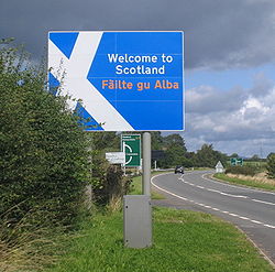
The border is marked by signposts welcoming travellers both into Scotland and into England.
is the area either side of the Anglo-Scottish border including parts of the modern council areas of Dumfries and Galloway
and the Scottish Borders
, and parts of the English counties
of Cumbria
, County Durham
and Northumberland
. It is a hilly area, with the Scottish Southern Uplands
to the north, and the Cheviot Hills
forming the border between the two countries to the south. From the Norman conquest of England until the reign of James VI of Scotland, who also became James I of England
, border clashes were common and the monarchs of both countries relied on Scottish Earls of March
and Lord Warden
of the Marches
to defend and control the frontier region
.
Historic Border clans include the following: Armstrong
, Beattie, Bannatyne, Bell, Briar, Douglas
, Elliot, Graham
, Hedley of Redesdale, Henderson, Irvine
, Jardine
, Kerr
, Little
, Moffat
, Nesbitt
, Ogilvy
, Porteous
, Scott
, Tweedie.
of the first Lord Warden of the Marches
to the early 17th century and the creation of the Middle Shires, promulgated after the personal union of England and Scotland under James VI of Scotland (James I of England)—the area around the border was known as the Scottish Marches
.
For centuries the Marches on either side of the boundary was an area of mixed allegiances, where families or clans switched which country or side they supported as suited their family interests at that time, and lawlessness abounded. Before the two kingdoms were united as the Kingdom of Great Britain
, the border clans would switch allegiance between the Scottish and English thrones depending on what was most favourable for the members of the clan. For a time a powerful local clan dominated a region on the border between England and Scotland. It was known as the Debatable Lands
and neither monarch's writ was heeded.
In 1603 the King placed George Home, 1st Earl of Dunbar
in charge of pacification of the borders. Courts were set up in the towns of the Middle Shires and known reivers were arrested. The more troublesome and lower classes were executed without trial; known as "Jeddart justice" (after the town of Jedburgh
in Roxburghshire
). Mass hanging soon became a common occurrence.
In 1607 James felt he could boast that "the Middle Shires" had "become the navel or umbilic of both kingdoms, planted and peopled with civility and riches". After ten years King James had succeeded; the Middle Shires had been brought under central law and order.
By the early 1620s the Borders were so peaceful that the Crown was able to scale down its operations.
Nevertheless, the Joint Commission continued it work, and as late as 25 September 1641 under King Charles II a local laird, Sir Richard Graham, was petitioning the Parliament of Scotland
"for regulating the disorders in the borders".
and Berwick-upon-Tweed
. Berwick only became properly annexed to Northumberland in the 19th century, and Berwickshire
is in Scotland, while the town is in England (though both the town and lands up to the Firth of Forth
belonged to the Kingdom of Northumbria in the Early Middle Ages
). Wendy Wood
moved the border signs to the middle of the River Tweed
as a protest.
The debatable lands, on the other hand, were long a hideaway for criminals.
Scotland
Scotland is a country that is part of the United Kingdom. Occupying the northern third of the island of Great Britain, it shares a border with England to the south and is bounded by the North Sea to the east, the Atlantic Ocean to the north and west, and the North Channel and Irish Sea to the...
and England
England
England is a country that is part of the United Kingdom. It shares land borders with Scotland to the north and Wales to the west; the Irish Sea is to the north west, the Celtic Sea to the south west, with the North Sea to the east and the English Channel to the south separating it from continental...
. It runs for 154 km (96 miles) between the River Tweed
River Tweed
The River Tweed, or Tweed Water, is long and flows primarily through the Borders region of Great Britain. It rises on Tweedsmuir at Tweed's Well near where the Clyde, draining northwest, and the Annan draining south also rise. "Annan, Tweed and Clyde rise oot the ae hillside" as the Border saying...
on the east coast and the Solway Firth
Solway Firth
The Solway Firth is a firth that forms part of the border between England and Scotland, between Cumbria and Dumfries and Galloway. It stretches from St Bees Head, just south of Whitehaven in Cumbria, to the Mull of Galloway, on the western end of Dumfries and Galloway. The Isle of Man is also very...
in the west. It is Scotland
Scotland
Scotland is a country that is part of the United Kingdom. Occupying the northern third of the island of Great Britain, it shares a border with England to the south and is bounded by the North Sea to the east, the Atlantic Ocean to the north and west, and the North Channel and Irish Sea to the...
's only land border. England shares a longer border with Wales
Wales
Wales is a country that is part of the United Kingdom and the island of Great Britain, bordered by England to its east and the Atlantic Ocean and Irish Sea to its west. It has a population of three million, and a total area of 20,779 km²...
.
Although it had long been the de facto border, it was legally established in 1237, by the Treaty of York
Treaty of York
The Treaty of York was an agreement between Henry III of England and Alexander II of Scotland, signed at York on 25 September 1237. It detailed the future status of several feudal properties and addressed other issues between the two kings, and indirectly marked the end of Scotland's attempts to...
between England and Scotland, with the exception of a small area around Berwick, which was taken by England in 1482. It is thus one of the oldest extant border
Border
Borders define geographic boundaries of political entities or legal jurisdictions, such as governments, sovereign states, federated states and other subnational entities. Some borders—such as a state's internal administrative borders, or inter-state borders within the Schengen Area—are open and...
s in the world, although Berwick was not initially fully annexed by England. (It was not included in Northumberland
Northumberland
Northumberland is the northernmost ceremonial county and a unitary district in North East England. For Eurostat purposes Northumberland is a NUTS 3 region and is one of three boroughs or unitary districts that comprise the "Northumberland and Tyne and Wear" NUTS 2 region...
for parliamentary purposes until 1885.)
For centuries until the Union of the Crowns
Union of the Crowns
The Union of the Crowns was the accession of James VI, King of Scots, to the throne of England, and the consequential unification of Scotland and England under one monarch. The Union of Crowns followed the death of James' unmarried and childless first cousin twice removed, Queen Elizabeth I of...
the region on either side of the boundary was a lawless territory suffering from the repeated raids in each direction of the Border Reivers
Border Reivers
Border Reivers were raiders along the Anglo–Scottish border from the late 13th century to the beginning of the 17th century. Their ranks consisted of both Scottish and English families, and they raided the entire border country without regard to their victims' nationality...
.
Following the Treaty of Union 1707 which united Scotland and England to form the Kingdom of Great Britain
Kingdom of Great Britain
The former Kingdom of Great Britain, sometimes described as the 'United Kingdom of Great Britain', That the Two Kingdoms of Scotland and England, shall upon the 1st May next ensuing the date hereof, and forever after, be United into One Kingdom by the Name of GREAT BRITAIN. was a sovereign...
, the Border continues to form the boundary of two distinct legal jurisdictions as the treaty between the two countries guaranteed the continued separation of English law
English law
English law is the legal system of England and Wales, and is the basis of common law legal systems used in most Commonwealth countries and the United States except Louisiana...
and Scots law
Scots law
Scots law is the legal system of Scotland. It is considered a hybrid or mixed legal system as it traces its roots to a number of different historical sources. With English law and Northern Irish law it forms the legal system of the United Kingdom; it shares with the two other systems some...
.
The age of legal capacity under Scots law
Scots law
Scots law is the legal system of Scotland. It is considered a hybrid or mixed legal system as it traces its roots to a number of different historical sources. With English law and Northern Irish law it forms the legal system of the United Kingdom; it shares with the two other systems some...
is 16, while it is 18 under English law
English law
English law is the legal system of England and Wales, and is the basis of common law legal systems used in most Commonwealth countries and the United States except Louisiana...
. The border villages of Gretna Green
Gretna Green
Gretna Green is a village in the south of Scotland famous for runaway weddings. It is in Dumfries and Galloway, near the mouth of the River Esk and was historically the first village in Scotland, following the old coaching route from London to Edinburgh. Gretna Green has a railway station serving...
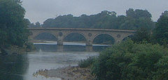
, Coldstream Bridge
Coldstream Bridge
Coldstream Bridge, linking Coldstream, Scottish Borders with Cornhill-on-Tweed, Northumberland, is an 18th century Grade II* listed bridge between England and Scotland, across the River Tweed. A plaque on the bridge commemorates the 1787 visit of the poet Robert Burns to the Coldstream...
and Lamberton were convenient for elope
Elope
To elope, most literally, merely means to run away with a girl and to not come back to the point of origination. More specifically, elopement is often used to refer to a marriage conducted in sudden and secretive fashion, usually involving hurried flight away from one's place of residence together...
rs from England who wanted to marry under Scottish laws, and marry without publicity.
The marine boundary was adjusted by the Scottish Adjacent Waters Boundaries Order 1999
Scottish Adjacent Waters Boundaries Order 1999
The Scottish Adjacent Waters Boundaries Order 1999 is a statutory instrument of the United Kingdom, defining "the boundaries between waters which are to be treated as internal waters or territorial sea of the United Kingdom adjacent to Scotland and those which are not"...
so that the boundary within the territorial waters
Territorial waters
Territorial waters, or a territorial sea, as defined by the 1982 United Nations Convention on the Law of the Sea, is a belt of coastal waters extending at most from the baseline of a coastal state...
(up to the 12 miles (19.3 km) limit) is 0.09 km north of the boundary for oil installations
North Sea oil
North Sea oil is a mixture of hydrocarbons, comprising liquid oil and natural gas, produced from oil reservoirs beneath the North Sea.In the oil industry, the term "North Sea" often includes areas such as the Norwegian Sea and the area known as "West of Shetland", "the Atlantic Frontier" or "the...
established by the Civil Jurisdiction (Offshore Activities) Order 1987.
The border is marked by signposts welcoming travellers both into Scotland and into England.
History
The border country, historically known as the Scottish MarchesScottish Marches
Scottish Marches was the term used for the Anglo-Scottish border during the late medieval and early modern eras—from the late 13th century, with the creation by Edward I of England of the first Lord Warden of the Marches to the early 17th century and the creation of the Middle Shires, promulgated...
is the area either side of the Anglo-Scottish border including parts of the modern council areas of Dumfries and Galloway
Dumfries and Galloway
Dumfries and Galloway is one of 32 unitary council areas of Scotland. It was one of the nine administrative 'regions' of mainland Scotland created in 1975 by the Local Government etc. Act 1973...
and the Scottish Borders
Scottish Borders
The Scottish Borders is one of 32 local government council areas of Scotland. It is bordered by Dumfries and Galloway in the west, South Lanarkshire and West Lothian in the north west, City of Edinburgh, East Lothian, Midlothian to the north; and the non-metropolitan counties of Northumberland...
, and parts of the English counties
Counties of England
Counties of England are areas used for the purposes of administrative, geographical and political demarcation. For administrative purposes, England outside Greater London and the Isles of Scilly is divided into 83 counties. The counties may consist of a single district or be divided into several...
of Cumbria
Cumbria
Cumbria , is a non-metropolitan county in North West England. The county and Cumbria County Council, its local authority, came into existence in 1974 after the passage of the Local Government Act 1972. Cumbria's largest settlement and county town is Carlisle. It consists of six districts, and in...
, County Durham
County Durham
County Durham is a ceremonial county and unitary district in north east England. The county town is Durham. The largest settlement in the ceremonial county is the town of Darlington...
and Northumberland
Northumberland
Northumberland is the northernmost ceremonial county and a unitary district in North East England. For Eurostat purposes Northumberland is a NUTS 3 region and is one of three boroughs or unitary districts that comprise the "Northumberland and Tyne and Wear" NUTS 2 region...
. It is a hilly area, with the Scottish Southern Uplands
Southern Uplands
The Southern Uplands are the southernmost and least populous of mainland Scotland's three major geographic areas . The term is used both to describe the geographical region and to collectively denote the various ranges of hills within this region...
to the north, and the Cheviot Hills
Cheviot Hills
The Cheviot Hills is a range of rolling hills straddling the England–Scotland border between Northumberland and the Scottish Borders.There is a broad split between the northern and the southern Cheviots...
forming the border between the two countries to the south. From the Norman conquest of England until the reign of James VI of Scotland, who also became James I of England
James I of England
James VI and I was King of Scots as James VI from 24 July 1567 and King of England and Ireland as James I from the union of the English and Scottish crowns on 24 March 1603...
, border clashes were common and the monarchs of both countries relied on Scottish Earls of March
Earl of March
The title The Earl of March has been created several times in the Peerage of Scotland and the Peerage of England. The title derived from the "marches" or boundaries between England and either Wales or Scotland , and was held by several great feudal families which owned lands in those border...
and Lord Warden
Lord Warden of the Marches
The Lord Warden of the Marches was an office in the governments of Scotland and England. The holders were responsible for the security of the border between the two nations, and often took part in military action....
of the Marches
Marches
A march or mark refers to a border region similar to a frontier, such as the Welsh Marches, the borderland between England and Wales. During the Frankish Carolingian Dynasty, the word spread throughout Europe....
to defend and control the frontier region
Border Country
Border Country is a novel by Raymond Williams. The book was re-published in December 2005 as one of the first group of titles in the Library of Wales series, having been out of print for several years. Written in English, the novel was first published in 1960.It is set in rural South Wales, close...
.
Clans
A 16th century Act of the Scottish Parliament talks about the chiefs of the border clans and a late 17th century statement by the Lord Advocate also uses both terms interchangeably. Although Lowland aristocrats may have increasingly liked to refer to themselves as 'families', the idea that the term 'clan' should be used of highland families alone is a 19th century convention.Historic Border clans include the following: Armstrong
Clan Armstrong
Clan Armstrong is an armigerous clan whose origins lie in Cumberland, south of the frontier between Scotland and England which was officially established in 1237....
, Beattie, Bannatyne, Bell, Briar, Douglas
Clan Douglas
Clan Douglas is an ancient Scottish kindred from the Scottish Lowlands taking its name from Douglas, South Lanarkshire, and thence spreading through the Scottish Borderland, Angus, Lothian and beyond. The clan does not currently have a chief, therefore it is considered an armigerous clan.The...
, Elliot, Graham
Clan Graham
Clan Graham is a Scottish clan who had territories in both the Scottish Highlands and Lowlands.-Origins:Legend has it that the first Graham was one Gramus who forced a breach in the Roman Antonine wall known as Graeme's Dyke in 420 A.D...
, Hedley of Redesdale, Henderson, Irvine
Clan Irvine
-Origins of the clan:As a surname Irvine is of territorial origins from one of two places of the same name. Firstly from Irving, an old parish in Dumfriesshire and from Irvine in Ayrshire....
, Jardine
Clan Jardine
-Origins of the clan:The Clan Jardine is believed to be of French origin. The French word jardin means garden or orchard and it is presumed that the Jardine family originally came from France. Members of the Jardine family travelled with William during the Norman conquest of England in 1066...
, Kerr
Clan Kerr
Clan Kerr is a Scottish clan that played an important role in the history of the Border country of Scotland.-Origins:The origins of the name Kerr are disputed as being either:*Caer *Ciar...
, Little
Clan Little
Clan Little is a Scottish clan of the Borders. The clan does not currently have a chief and is therefore considered an armigerous clan.-Origins of the Clan:...
, Moffat
Clan Moffat
-Origins of the clan:The Moffats are an ancient Borders family who were influential and powerful as far back as the time of Sir William Wallace. The ancestor of the Moffats most likely gave their name to the town of Moffat in Dumfriesshire. The origin of the name itself is thought to be Norse...
, Nesbitt
Clan Nesbitt
Clan Nesbitt is a Scottish clan recognised by the Lord Lyon King of Arms and first mentioned in a Scottish charter of 1139. It is a lowland family centred in Berwickshire, East Lothian, Edinburgh and Ayrshire, with a significant historical presence in Northumberland and Durham...
, Ogilvy
Clan Ogilvy
-Origins of the clan:The Ogilvys are one of the most distinguished families in Scotland and take their name from Gillebride the second son of Gille Chriosd, Celtic Earl of Angus...
, Porteous
Porteous family
-History:The earliest records for members of the Porteous family in Peeblesshire date back to the early part of the fifteenth century.The earliest possible reference, according to Lord Lyon King of Arms in Edinburgh, is to a Guillaume Porteuse , who arrived from Normandy c 1400 under the patronship...
, Scott
Clan Scott
Clan Scott is a Scottish clan. Clan Scott is not a Highland clan but Lowland, from the Borders region of Scotland. Families and clans from this area prefer to be known as Borderers instead of Lowlanders.-Origins:...
, Tweedie.
Scottish Marches
During late medieval and early modern eras—from the late 13th century, with the creation by Edward I of EnglandEdward I of England
Edward I , also known as Edward Longshanks and the Hammer of the Scots, was King of England from 1272 to 1307. The first son of Henry III, Edward was involved early in the political intrigues of his father's reign, which included an outright rebellion by the English barons...
of the first Lord Warden of the Marches
Lord Warden of the Marches
The Lord Warden of the Marches was an office in the governments of Scotland and England. The holders were responsible for the security of the border between the two nations, and often took part in military action....
to the early 17th century and the creation of the Middle Shires, promulgated after the personal union of England and Scotland under James VI of Scotland (James I of England)—the area around the border was known as the Scottish Marches
Scottish Marches
Scottish Marches was the term used for the Anglo-Scottish border during the late medieval and early modern eras—from the late 13th century, with the creation by Edward I of England of the first Lord Warden of the Marches to the early 17th century and the creation of the Middle Shires, promulgated...
.
For centuries the Marches on either side of the boundary was an area of mixed allegiances, where families or clans switched which country or side they supported as suited their family interests at that time, and lawlessness abounded. Before the two kingdoms were united as the Kingdom of Great Britain
Kingdom of Great Britain
The former Kingdom of Great Britain, sometimes described as the 'United Kingdom of Great Britain', That the Two Kingdoms of Scotland and England, shall upon the 1st May next ensuing the date hereof, and forever after, be United into One Kingdom by the Name of GREAT BRITAIN. was a sovereign...
, the border clans would switch allegiance between the Scottish and English thrones depending on what was most favourable for the members of the clan. For a time a powerful local clan dominated a region on the border between England and Scotland. It was known as the Debatable Lands
Debatable Lands
The Debatable Lands, also known as Debatable ground, batable ground or thriep lands, was land lying between Scotland and England, formerly in question to which it belonged, when they were distinct kingdoms...
and neither monarch's writ was heeded.
Middle Shires
King James VI & I decreed that the Borders should be renamed 'the Middle Shires'. In 1605 he established a single commission of ten drawn from equally Scotland and England to bring law and order to the region. Reivers could no longer escape justice by crossing from England to Scotland or vice versa. The rough-and-ready Border Laws were abolished and the folk of the middle shires found they had to obey the law of the land like all other subjects.In 1603 the King placed George Home, 1st Earl of Dunbar
George Home, 1st Earl of Dunbar
George Home, 1st Earl of Dunbar, KG, PC was, in the last decade of his life, the most prominent and most influential Scotsman in England. His work lay in the King's Household and in the control of the State Affairs of Scotland and he was the King's chief Scottish advisor...
in charge of pacification of the borders. Courts were set up in the towns of the Middle Shires and known reivers were arrested. The more troublesome and lower classes were executed without trial; known as "Jeddart justice" (after the town of Jedburgh
Jedburgh
Jedburgh is a town and former royal burgh in the Scottish Borders and historically in Roxburghshire.-Location:Jedburgh lies on the Jed Water, a tributary of the River Teviot, it is only ten miles from the border with England and is dominated by the substantial ruins of Jedburgh Abbey...
in Roxburghshire
Roxburghshire
Roxburghshire or the County of Roxburgh is a registration county of Scotland. It borders Dumfries to the west, Selkirk to the north-west, and Berwick to the north. To the south-east it borders Cumbria and Northumberland in England.It was named after the Royal Burgh of Roxburgh...
). Mass hanging soon became a common occurrence.
In 1607 James felt he could boast that "the Middle Shires" had "become the navel or umbilic of both kingdoms, planted and peopled with civility and riches". After ten years King James had succeeded; the Middle Shires had been brought under central law and order.
By the early 1620s the Borders were so peaceful that the Crown was able to scale down its operations.
Nevertheless, the Joint Commission continued it work, and as late as 25 September 1641 under King Charles II a local laird, Sir Richard Graham, was petitioning the Parliament of Scotland
Parliament of Scotland
The Parliament of Scotland, officially the Estates of Parliament, was the legislature of the Kingdom of Scotland. The unicameral parliament of Scotland is first found on record during the early 13th century, with the first meeting for which a primary source survives at...
"for regulating the disorders in the borders".
On the border
- Solway FirthSolway FirthThe Solway Firth is a firth that forms part of the border between England and Scotland, between Cumbria and Dumfries and Galloway. It stretches from St Bees Head, just south of Whitehaven in Cumbria, to the Mull of Galloway, on the western end of Dumfries and Galloway. The Isle of Man is also very...
- Union Bridge (Tweed)Union Bridge (Tweed)The Union Bridge is a suspended-deck suspension bridge that spans the River Tweed between Horncliffe, Northumberland, England and Fishwick, Borders, Scotland...
- Pennine WayPennine WayThe Pennine Way is a National Trail in England. The trail runs from Edale, in the northern Derbyshire Peak District, north through the Yorkshire Dales and the Northumberland National Park and ends at Kirk Yetholm, just inside the Scottish border. The path runs along the Pennine hills, sometimes...
- Scots' DikeScots' DikeThe Scots' Dike or dyke is a three and a half mile / 5.25 km long linear earthwork, constructed by the English and the Scots in the year 1552 to mark the division of the Debatable lands and thereby settle the exact boundary between the Kingdoms of Scotland and England.-Introduction:The...
England
Cumbria
- ArthuretArthuretArthuret is a civil parish in the Carlisle district of Cumbria, England. According to the 2001 census it had a population of 2,434. The parish includes the small town of Longtown and the village of Easton...
- Blackpool GateBlackpool GateBlackpool Gate is a settlement in the civil parish of Bewcastle, which is in the district of the City of Carlisle in the county of Cumbria, England.Blackpool Gate lies some five miles south of the border with Scotland and has existed since Roman occupation....
- Carlisle
- HethersgillHethersgillHethersgill is a village and a civil parish in the City of Carlisle district, in the county of Cumbria, England. Hethersgill has a church called St Mary's Church. In 2001 the population of the civil parish of Hethersgill was 382.- External links :*...
- KershopefootKershopefootKershopefoot is a small village in Cumbria, England. It is located very close to the Scotland-England border and is near the Kershope Burn and the Liddel Water....
- LongtownLongtown, CumbriaLongtown is a small town in northern Cumbria, England, with a population of around 3,000. It is in the parish of Arthuret and on the River Esk, not far from the Anglo-Scottish border. Nearby was the Battle of Arfderydd....
- CountyHistoric counties of EnglandThe historic counties of England are subdivisions of England established for administration by the Normans and in most cases based on earlier Anglo-Saxon kingdoms and shires...
of CumberlandCumberlandCumberland is a historic county of North West England, on the border with Scotland, from the 12th century until 1974. It formed an administrative county from 1889 to 1974 and now forms part of Cumbria.... - SkitbySkitbySkitby is a hamlet in the English county of Cumbria.Skitby lies northeast of the village of Smithfield.- External links :...
- StapletonStapleton, CumbriaStapleton is a village and a civil parish in the City of Carlisle district, in the county of Cumbria, England. Stapleton has a church called St Mary's Church.- External links :* http://www.stevebulman.f9.co.uk/cumbria/1901/stapleton.html...
Northumberland
- AlnwickAlnwickAlnwick is a small market town in north Northumberland, England. The town's population was just over 8000 at the time of the 2001 census and Alnwick's district population was 31,029....
and Alnwick CastleAlnwick CastleAlnwick Castle is a castle and stately home in the town of the same name in the English county of Northumberland. It is the residence of the Duke of Northumberland, built following the Norman conquest, and renovated and remodelled a number of times. It is a Grade I listed building.-History:Alnwick... - AncroftAncroftAncroft is a village and civil parish in Northumberland, England. Prior to 1844, Ancroft lay within the Islandshire exclave of County Durham. It is south of Berwick-upon-Tweed, and has a population of 885....
- BamburghBamburghBamburgh is a large village and civil parish on the coast of Northumberland, England. It has a population of 454.It is notable for two reasons: the imposing Bamburgh Castle, overlooking the beach, seat of the former Kings of Northumbria, and at present owned by the Armstrong family ; and its...
and Bamburgh CastleBamburgh CastleBamburgh Castle is an imposing castle located on the coast at Bamburgh in Northumberland, England. It is a Grade I listed building.-History:... - Barmoor CastleBarmoor CastleBarmoor Castle is a privately owned 19th century country house built on an ancient site in Northumberland. It is a Grade II* listed building...
- Barrow BurnBarrow BurnBarrow Burn is a village in Northumberland, England.- Governance :Barrow Burn is in the parliamentary constituency of Berwick-upon-Tweed....
- BeadnellBeadnellBeadnell is a village and civil parish in Northumberland, England. It is situated about south-east of Bamburgh, on the North Sea coast, and has a population of 528....
- BelfordBelford, NorthumberlandBelford is a village and civil parish in Northumberland, England about halfway between Alnwick and Berwick-upon-Tweed, a few miles inland from the east coast and just off the Great North Road, the A1...
- Berwick-upon-TweedBerwick-upon-TweedBerwick-upon-Tweed or simply Berwick is a town in the county of Northumberland and is the northernmost town in England, on the east coast at the mouth of the River Tweed. It is situated 2.5 miles south of the Scottish border....
, and the former boroughBerwick-upon-Tweed (borough)Berwick-upon-Tweed was a local government district and borough in Northumberland in the north-east of England, on the border with Scotland. The district had a resident population of 25,949 according to the 2001 census, which also notes that it is the most ethnically homogeneous in the country, with... - BowsdenBowsdenBowsden is a village and civil parish in Northumberland, England. It is about to the south of Berwick-upon-Tweed, inland from the North Sea coast at Lindisfarne, and has a population of 157.-Landmarks:...
- BranxtonBranxton, NorthumberlandBranxton is a village and civil parish in northern Northumberland, England. It lies about from the England-Scotland border and about from the Scottish border town of Coldstream, just off the A697 Newcastle-Edinburgh road...
- ByrnessByrnessLocated in Northumberland, Byrness the last village in England before the A68 climbs the Cheviot Hills to cross Carter Bar into Scotland. It is situated approximately to the north-west of Newcastle on the A68. Byrness's village church features a stained-glass window commemorating the workers who...
- CarhamCarhamCarham is a village in Northumberland, England. The village lies on the south side of the River Tweed about west of Coldstream.- History :Near to Carham are the extensive remains of Early British camps and a bronze sword, now in the British Museum, discovered in the nearby Tweed.Carham on the...
- Catcleugh ReservoirCatcleugh ReservoirCatcleugh Reservoir is a reservoir in Northumberland, England adjacent to the A68 road; just north of Byrness; and to the south of the border with Scotland.-History:...
- ChattonChattonChatton is a village in Northumberland, in England. It is situated approximately to the east of Wooler. The village has amenities which include a pub and village shop, and also has a number of historic artifacts, with cup and ring marks and a kettle stone.-External links:* *...
- Chillingham CastleChillingham CastleChillingham Castle is a medieval castle in the village of Chillingham in the northern part of Northumberland, England. It was the seat of the Grey family and their descendants the Earls of Tankerville from the 13th century until the 1980s. The Chillingham Wild Cattle, formerly associated with the...
- Cornhill-on-TweedCornhill-on-TweedCornhill-on-Tweed is a village and civil parish in Northumberland, in England about to the east of Coldstream.To the south and west of the village are the hamlets of West Learmouth and East Learmouth.- History :...
- CrookhamCrookham, NorthumberlandCrookham is a village on the River Till in Northumberland, in England. It is situated approximately to the east of Coldstream and northwest of Wooler. It has two farms, which are both west of the village. They are called Crookham Eastfield and Crookham Westfield...
- DoddingtonDoddington, NorthumberlandThe village and parish of Doddington is situated on the south side of the Milfield Plain, approximately 2 miles from the town of Wooler in the county of Northumberland. Notable buildings in Doddington include Doddington Hall, and the Anglican Church of St Mary and St Michael, which was built in the...
- DuddoDuddoDuddo is a village in Northumberland situated about south west of Berwick on Tweed.- Landmarks :The ruinous remains of Duddo Tower occupy a prominence to the south of the village....
and Duddo TowerDuddo TowerDuddo Tower is a Scheduled Ancient Monument and a Grade II listed building comprising the ruinous remains of an ancient pele tower and 16th century tower house, situated on a prominence on the south side of the village of Duddo, Northumberland, England.... - EtalEtalEtal is a small village in the far north of the county of Northumberland, England which shares a parish with nearby Ford. It lies on a bridging point of the River Till ten miles south west of Berwick-Upon-Tweed, and can boast the substantial ruins of a medieval castle currently owned by English...
and Etal CastleEtal CastleEtal Castle is a medieval English castle situated at Etal, Cornhill on Tweed, Northumberland, England. It is a Scheduled Ancient Monument and a Grade I listed building.... - Fowberry TowerFowberry TowerFowberry Tower is a Grade II* listed mansion house, situated on the banks of the River Till, near Chatton, Northumberland.The Manor of Fowberry was owned by the Fowberry family for over 400 years and their 16th century tower house incorporated the remains of an original pele tower.In the late 16th...
- GoswickGoswickGoswick is a hamlet in Northumberland, England, situated approximately south-east of Berwick-upon-Tweed, England, between the A1 and the North Sea coast.-Goswick station:...
- GreysteadGreysteadGreystead is a village in Northumberland, England west of Bellingham.- Governance :Greystead is in the parliamentary constituency of Hexham.-External links :*...
- HaggerstonHaggerston, NorthumberlandHaggerston is a hamlet located in the county of Northumberland, England about south of Berwick-upon-Tweed and adjacent to the A1 road. Historically, it was a baronetcy in the civil parish of Ancroft, then located in County Durham...
and Haggerston CastleHaggerston CastleHaggerston Castle was a castle located in the county of Northumberland, England at Haggerston about south of Berwick-upon-Tweed. Only the tower and the rotunda remain... - HorncliffeHorncliffeHorncliffe is a village in the county of Northumberland, England. It lies on the south bank of the River Tweed about south west of Berwick-upon-Tweed, and about north east of Norham and is the most northerly village in England.- Governance :...
- HowtelHowtelHowtel is a village in Northumberland, England about northwest of Wooler. The name Howtel is thought to mean Low Ground with a Holt or Wood.- History :...
- IslandshireIslandshireIslandshire was an area of Northumberland, England, comprising Lindisfarne or Holy Island, plus five parishes on the mainland.It is historically associated with the Bishop of Durham, and was administratively an exclave of County Palatinate of Durham...
- KielderKielder, NorthumberlandKielder Village is a small settlement in North Tynedale, Northumberland, England. Located at the head of Kielder Water and in the north west of Kielder Forest, the village is from the Scottish border.-History:...
, Kielder ForestKielder ForestKielder Forest is a large forestry plantation in Northumberland, England, surrounding the reservoir Kielder Water. It is the largest man-made woodland in Europe...
and Kielder WaterKielder WaterKielder Water is a large artificial reservoir in Northumberland in North East England. It is the largest artificial lake in the United Kingdom by capacity and it is surrounded by Kielder Forest, the largest human-made woodland in Europe. It was planned in the late 1960s to satisfy an expected rise... - KilhamKilham, NorthumberlandKilham is a hamlet and civil parish in the English county of Northumberland, located west of Wooler, east of Kelso, south west of Berwick upon Tweed and north west of Morpeth. It lies on the northern edge of the Northumberland National Park in Glendale...
- KirknewtonKirknewton, NorthumberlandKirknewton is a Northumbrian village to the north of the county of Northumberland, about from the town of Wooler and roughly the same distance to the Scottish Borders...
- LilburnLilburn, NorthumberlandLilburn is a small village in Northumberland, England. It is located in the on the edge of the Cheviots. The local farming estate is centred on Lilburn Tower.The area is noted for its large number of earthworks and remains of prehistoric settlements....
and Lilburn TowerLilburn TowerLilburn Tower is a privately owned 19th century mansion house at Lilburn, near Wooler, Northumberland. The property is a Grade II* listed building and forming part of the Lilburn Estate... - LindisfarneLindisfarneLindisfarne is a tidal island off the north-east coast of England. It is also known as Holy Island and constitutes a civil parish in Northumberland...
and Lindisfarne CastleLindisfarne CastleLindisfarne Castle is a 16th-century castle located on Holy Island, near Berwick-upon-Tweed, Northumberland, England, much altered by Sir Edwin Lutyens in 1901. The island is accessible from the mainland at low tide by means of a causeway.-History:... - LowickLowick, NorthumberlandLowick is a village in Northumberland, England. It appears in records as early as 1181 as Lowich, and in 1242 as Lowyc. The name derives from Old English meaning settlement on the River Low.-Landmarks:...
- MiddletonMiddleton, NorthumberlandMiddleton is a civil parish in Northumberland, England. The parish is situated on the North Sea coast, south of the island of Lindisfarne, and contains the villages of Middleton, Ross, Detchant and Elwick; all are shrunken medieval villages. Both the A1 London to Edinburgh road and East Coast...
- MilfieldMilfieldMilfield is a village in Northumberland, England about northwest of Wooler. The A697 road passes through the village.- History :Milfield is the likely location of the Northumbrian royal settlement of Maelmin, given "mael" is a Brythonic word meaning "field"...
- MindrumMindrumMindrum is a village in Northumberland, England, in the district of Berwick-upon-Tweed.- Governance :Mindrum is in the parliamentary constituency of Berwick-upon-Tweed....
- MorpethMorpeth, NorthumberlandMorpeth is the county town of Northumberland, England. It is situated on the River Wansbeck which flows east through the town. The town is from the A1, which bypasses it. Since 1981, it has been the administrative centre of the County of Northumberland. In the 2001 census the town had a population...
- NorhamNorhamNorham is a village in Northumberland, England, just south of the River Tweed and the border with Scotland.It is the site of the 12th century Norham Castle, and was for many years the centre for the Norhamshire exclave of County Durham...
and Norham CastleNorham CastleNorham Castle is a partly ruined castle in Northumberland, England, overlooking the River Tweed, on the border between England and Scotland. It is a Grade I listed building and a Scheduled Ancient Monument... - North SunderlandNorth SunderlandNorth Sunderland is a fishing village on the coast of Northumberland, England, and adjacent to Seahouses.- Governance : North Sunderland is in the parliamentary constituency of Berwick-upon-Tweed.-External links:* ....
- OtterburnOtterburn, NorthumberlandOtterburn is a small village in Northumberland, England, northwest of Newcastle Upon Tyne on the banks of the River Rede, near the confluence of the Otter Burn, from which the village derives its name. It lies within the Cheviot Hills about from the Scottish border...
- RedesdaleRedesdaleRedesdale is a valley iin the western part of the county of Northumberland, in northeast England. This area contains the valley of the River Rede, a tributary of the North Tyne River. Redesdale includes the settlements of Elsdon, Otterburn, Rochester, Byrness and Carter Bar.Historically this...
& River RedeRiver RedeThe Rede is a river in Northumberland, England. The river rises on Carter Fell on the Anglo-Scottish border feeding Catcleugh Reservoir and joins the River North Tyne below the village of Redesmouth-See also:*Carter Bar*List of places in Northumberland... - ScremerstonScremerstonScremerston is a village in Northumberland, England. The village lies on the North Sea coast about south of Berwick-upon-Tweed. Scremerston lies adjacent to the A1, the main national north/south trunk road, providing access to Newcastle upon Tyne to the south, and to the Scottish capital Edinburgh...
- SpittalSpittal, NorthumberlandSpittal is a small seaside resort in northern Northumberland, England, and is located near Berwick-upon-Tweed. Spittal Beach as one of the best beaches in Northumberland....
- Twizell CastleTwizell CastleTwizell Castle is a Grade II* listed building and a Scheduled Ancient Monument which stands on a bend of the River Till at Tillmouth Park, Northumberland, northern England. Below it, the medieval Twizell bridge spans the river. It is located south-west of Berwick Upon Tweed. The site is visible...
- Wark on TweedWark on TweedWark on Tweed is a village in the English county of Northumberland. It lies about south west of Berwick-upon-Tweed...
- WoolerWoolerWooler is a small town in Northumberland, England. It lies on the edge of the Northumberland National Park, by the Cheviot Hills and so is a popular base for walkers and is referred to as the "Gateway to the Cheviots"...
- YeaveringYeaveringYeavering is a very small hamlet in the north-east corner of the civil parish of Kirknewton in the English county of Northumberland. It is located on the River Glen at the northern edge of the Cheviot Hills...
Scotland
Dumfries and Galloway
- Auchenrivock TowerAuchenrivock TowerAuchenrivock Tower is a ruined late 16th Century tower house situated near Langholm, Dumfries and Galloway. The remains of the tower, which rise 8 feet at their highest, are currently built into a garden wall....
- CanonbieCanonbieCanonbie is a small village in Dumfries and Galloway in south west Scotland, six miles south of Langholm and two miles north of the Anglo-Scottish border. It is on the A7 road from Carlisle to Edinburgh, and the River Esk flows through it...
- Gilnockie TowerGilnockie TowerGilnockie Tower is a 16th-century tower house, located at the hamlet of Hollows, 2.3 km north of Canonbie, in Dumfries and Galloway, south-west Scotland. The tower is situated on the west bank of the River Esk. It was originally known as Hollows Tower...
- GretnaGretna, Dumfries and GallowayGretna is a town in Dumfries and Galloway, Scotland. Because they are near the Anglo-Scottish border, nearby Gretna Green and to a lesser extent Gretna, are historically linked to weddings because of the more liberal marriage laws in Scotland...
- Gretna GreenGretna GreenGretna Green is a village in the south of Scotland famous for runaway weddings. It is in Dumfries and Galloway, near the mouth of the River Esk and was historically the first village in Scotland, following the old coaching route from London to Edinburgh. Gretna Green has a railway station serving...
- LangholmLangholmLangholm , also known colloquially as the "Muckle Toon", is a burgh in Dumfries and Galloway, Scotland, on the River Esk and the A7 road.- History:...
- RowanburnRowanburnRowanburn is a hamlet in Eskdale, Dumfriesshire, in southern Scotland, near Canonbie, and about 5 miles south-east of Langholm. It is administered by Dumfries and Galloway Council....
Borders
- AllantonAllanton, Scottish BordersAllanton is a small village in the pre-1975 ancient county of Berwickshire, now an administrative area of the Scottish Borders region of Scotland....
- Ayton
- BirghamBirghamBirgham is a village in Berwickshire, parish of Eccles in the Scottish Borders area of Scotland, near Coldstream and the River Tweed, on the A698...
- Cessford CastleCessford CastleCessford Castle is a ruined L-plan castle lying equidistant between the Royal Burgh of Jedburgh, and the Burghs of Kelso and Kirk Yetholm, in the historic county of Roxburghshire, now a division of the Scottish Borders...
- ChirnsideChirnsideChirnside is a hillside village in Berwickshire in Scotland, west of Berwick-upon-Tweed and east of Duns.-Notables:David Hume, the Scottish Enlightenment philosopher, lived in Ninewells House, just south of the village...
- ColdstreamColdstreamColdstream is a small town in the Borders district of Scotland. It lies on the north bank of the River Tweed in Berwickshire, while Northumberland in England lies to the south bank, with Cornhill-on-Tweed the nearest village...
- DinlabyreDinlabyreDinlabyre is a village on the B6357 in Liddesdale, on the edge of the Newcastleton Forest, close to Castleton, in the Scottish Borders area of Scotland, in the former Roxburghshire....
- EcclesEccles, Scottish BordersthumbEccles is a village and agricultural parish near Kelso in Berwickshire in the Scottish Borders area of Scotland. The village is conjoined with Birgham and Leitholm...
- Eden WaterEden WaterEden Water is a tributary of the River Tweed in the Scottish Borders area of Scotland. "Water" is the Lowland Scots term for a small river.The Eden Burn rises to the east of Lauder at Corsbie Moor. The Eden Water passes Bassendean village and Bassendean House and the hamlets of Fawside and Mack's...
- EdgerstonEdgerstonEdgerston is a village and an estate about 8 miles north of the Anglo-Scottish border, south of Jedburgh in the Scottish Borders area of Scotland in the former Roxburghshire.Thomas Rutherfurd built Edgerston House in 1695...
- EdnamEdnamDisambiguation: "Ednam" can also refer to the aristocratic title Viscount EdnamEdnam is a small village near Kelso in the Scottish Borders area of Scotland....
- EdringtonEdringtonEdrington is a medieval estate occupying the lower part of Mordington parish in Berwickshire, Scottish Borders, Scotland, five miles west of Berwick-upon-Tweed. From probably the 14th century, if not earlier, a castle occupied the steep hill above the mill of the same name on the Whiteadder Water...
- EdromEdromEdrom is a small village in the pre-1975 ancient county of Berwickshire, now an administrative area of the Scottish Borders region of Scotland....
- EyemouthEyemouthEyemouth , historically spelt Aymouth, is a small town and civil parish in Berwickshire, in the Scottish Borders area of Scotland. It is east of the main north-south A1 road and just north of Berwick-upon-Tweed. It has a population of circa 3,420 people .The town's name comes from its location at...
- FogoFogo, Scottish BordersFogo is a village in the county of Berwickshire, in the Borders of Scotland, 3 miles south of Duns, on the Blackadder Water.The name Fogo means "foggage pit, den or hollow"....
- FouldenFoulden, Scottish BordersFoulden is a civil parish and village in the Berwickshire area of Scottish Borders, Scotland, situated not far above the Whiteadder Water, and west of Berwick-upon-Tweed....
- HermitageHermitage, Scottish BordersHermitage is a village near Newcastleton, on the B6399, in the Scottish Borders area of Scotland.-External links:**http://www.geograph.org.uk/photo/320847...
and Hermitage CastleHermitage CastleHermitage Castle is a semi-ruined castle in the border region of Scotland. It is under the care of Historic Scotland. The Castle has a reputation, both from its history and its appearance, as one of the most sinister and atmospheric in Scotland.... - Hilly LinnHilly Linn-References:...
- HiltonHilton, BerwickshireHilton is a village in Berwickshire, Scottish Borders, Scotland....
- Hume CastleHume CastleHume Castle is the heavily modified remnants of a late 12th or early 13th century "Castle of enceinte".The village of Hume is located between Greenlaw and Kelso, two miles north of the village of Stichill, in Berwickshire, Scotland....
- HuttonHutton, Scottish BordersHutton is a small village in the pre-1975 ancient county of Berwickshire, now an administrative area of the Scottish Borders region of Scotland. It is a traditional, country village surrounded by farmland.-Locality:...
- JedburghJedburghJedburgh is a town and former royal burgh in the Scottish Borders and historically in Roxburghshire.-Location:Jedburgh lies on the Jed Water, a tributary of the River Teviot, it is only ten miles from the border with England and is dominated by the substantial ruins of Jedburgh Abbey...
- KelsoKelso-Places:Australia* Kelso, New South Wales, a suburb of Bathurst* Kelso, Tasmania, a small village in the north of Tasmania* Kelso, Queensland, a suburb of Townsville, QueenslandCanada...
- Kirk YetholmKirk YetholmKirk Yetholm is a village in the Scottish Borders region of Scotland, south east of Kelso and less than west of the border. The first mention is of its church in the 13th century. Its sister town is Town Yetholm which lies half a mile across the Bowmont Water...
& Town YetholmTown YetholmTown Yetholm is a small village in the Scottish Borders in the valley of the Bowmont Water opposite Kirk Yetholm. The centre of the small village is made up of the village green surrounded by the village shop, the Plough Hotel Public House a few houses to the south and a row of terraced dwellings... - LadykirkLadykirk, Scottish BordersLadykirk is a village on the B6470 in the Scottish Borders area of Scotland, and the former Berwickshire, just north of the River Tweed and the Anglo-Scottish border. The town was formerly known as Upsettlington, but King James IV of Scotland renamed the town Ladykirk; the church is also known as St...
- Lamberton
- LeitholmLeitholmLeitholm is a village in the Scottish Borders area of Scotland, north-west of Coldstream, in the former county of Berwickshire.Other places nearby include the Crosshall cross, Duns, Eccles, Ednam, Fogo, Greenlaw, Hume Castle, Polwarth, Westruther....
- LiddesdaleLiddesdaleLiddesdale, the valley of the Liddel Water, in the County of Roxburgh, southern Scotland, extends in a south-westerly direction from the vicinity of Peel Fell to the River Esk, a distance of...
- MordingtonMordingtonMordington is an agricultural parish in the extreme south-east of Berwickshire in the Scottish Borders region. It is five miles from Berwick-upon-Tweed and borders Northumberland to the east, and south , Foulden to the west, and Lamberton to the north. The parish is bisected by the A6105 Berwick to...
- MorebattleMorebattleMorebattle is a village in the Scottish Borders area of Scotland, on the B6401, seven miles south of Kelso, Scottish Borders, beside the Kale Water, a tributary of the River Teviot.The nearby Linton Loch was drained in the 19th century to improve agriculture....
- MowhaughMowhaughMowhaugh is a hamlet and farm steading near the Calroust Burn and the Bowmont Water, near Morebattle, in the Scottish Borders area of Scotland, and in the former Roxburghshire. It is situated about 5 miles from the Anglo-Scottish Border....
- NewcastletonNewcastletonNewcastleton, or Copshaw Holm is a village in the Scottish Borders, a few miles from the border of Scotland with England. The village is in Liddesdale and is on the Liddel Water, and is the site of Hermitage Castle.-History:...
- OxnamOxnamOxnam is a village near Jedburgh, in Roxburghshire in the Scottish Borders area of Scotland. It is a primarily residential town.The placename Oxnam is from Old English oxa "oxen" and ham "village", the meaning being "village where ox are bred"...
- PaxtonPaxton, Scottish BordersPaxton is a small village near the B6461 and the B6460, in the pre-1975 ancient county of Berwickshire, now an administrative area of the Scottish Borders region of Scotland. It lies 1 mile west of the border with Northumberland, near Berwick-upon-Tweed...
- RoxburghRoxburghRoxburgh , also known as Rosbroch, is a village, civil parish and now-destroyed royal burgh. It was an important trading burgh in High Medieval to early modern Scotland...
and Roxburgh CastleRoxburgh CastleRoxburgh Castle was a castle sited near Kelso, in the Borders region of Scotland, in the former Roxburghshire.-History:The castle was founded by King David I. In 1174 it was surrendered to England after the capture of William I at Alnwick, and was often in English hands thereafter. The Scots made... - SaughtreeSaughtreeSaughtree is a village by the B6357 and the Liddel Water, in Liddesdale, near Newcastleton, in the Scottish Borders area of Scotland.The Dawston Burn is a tributary of the Liddel Water. Saughtree Fell is a hill which rises to 450m...
- SouthdeanSouthdeanSouthdean is a village in the Scottish Borders area of Scotland, on the A6088, by the Rule Water and in the Wauchope Forest area. Other settlements nearby include Abbotrule, Hobkirk, Bedrule, Hallrule, Bonchester Bridge, Denholm and the Swinnie Forest....
- SwintonSwinton, Scottish BordersSwinton is a small village in the Scottish Borders. It is in the former county of Berwickshire, around south-east of Duns, and north-west of the Anglo-Scottish border.-History:...
- TimpanheckTimpanheckTimpanheck is a village in Annandale, Scottish Borders.-External links:**...
- WhitsomeWhitsomeWhitsome is a small rural village in the Scottish Borders area of Scotland, on the B6437, near Duns, Fogo, Leitholm, Ladykirk and Swinton.-Place-name meaning:...
Rivers
- River EskRiver Esk, Dumfries and GallowayThe River Esk is a river in Dumfries and Galloway, Scotland, that flows into the Solway Firth. It also flows for a small way through the English county of Cumbria before entering the Solway....
- River RedeRiver RedeThe Rede is a river in Northumberland, England. The river rises on Carter Fell on the Anglo-Scottish border feeding Catcleugh Reservoir and joins the River North Tyne below the village of Redesmouth-See also:*Carter Bar*List of places in Northumberland...
- River SarkRiver SarkDisambiguation: for other meanings, please see Sark The River Sark or Sark Water is a river best known for forming part of the western border between Scotland and England...
- River TweedRiver TweedThe River Tweed, or Tweed Water, is long and flows primarily through the Borders region of Great Britain. It rises on Tweedsmuir at Tweed's Well near where the Clyde, draining northwest, and the Annan draining south also rise. "Annan, Tweed and Clyde rise oot the ae hillside" as the Border saying...
- Whiteadder WaterWhiteadder WaterWhiteadder Water is a river in East Lothian and Berwickshire, Scotland. It also flows for a very short distance through Northumberland before joining the River Tweed...
- Liddel WaterLiddel WaterLiddel Water is a river running through southern Scotland and northern England, for much of its course forming the border between the two countries, and was formerly one of the boundaries of the Debatable Lands....
Controversial territories
Although the border has been amongst the most stable in history, it has not been without its controversies, notably the debatable landsDebatable Lands
The Debatable Lands, also known as Debatable ground, batable ground or thriep lands, was land lying between Scotland and England, formerly in question to which it belonged, when they were distinct kingdoms...
and Berwick-upon-Tweed
Berwick-upon-Tweed
Berwick-upon-Tweed or simply Berwick is a town in the county of Northumberland and is the northernmost town in England, on the east coast at the mouth of the River Tweed. It is situated 2.5 miles south of the Scottish border....
. Berwick only became properly annexed to Northumberland in the 19th century, and Berwickshire
Berwickshire
Berwickshire or the County of Berwick is a registration county, a committee area of the Scottish Borders Council, and a lieutenancy area of Scotland, on the border with England. The town after which it is named—Berwick-upon-Tweed—was lost by Scotland to England in 1482...
is in Scotland, while the town is in England (though both the town and lands up to the Firth of Forth
Firth of Forth
The Firth of Forth is the estuary or firth of Scotland's River Forth, where it flows into the North Sea, between Fife to the north, and West Lothian, the City of Edinburgh and East Lothian to the south...
belonged to the Kingdom of Northumbria in the Early Middle Ages
Early Middle Ages
The Early Middle Ages was the period of European history lasting from the 5th century to approximately 1000. The Early Middle Ages followed the decline of the Western Roman Empire and preceded the High Middle Ages...
). Wendy Wood
Wendy Wood
Wendy Wood was a well-known campaigner for Scottish independence and founder of the Scottish Patriots...
moved the border signs to the middle of the River Tweed
River Tweed
The River Tweed, or Tweed Water, is long and flows primarily through the Borders region of Great Britain. It rises on Tweedsmuir at Tweed's Well near where the Clyde, draining northwest, and the Annan draining south also rise. "Annan, Tweed and Clyde rise oot the ae hillside" as the Border saying...
as a protest.
The debatable lands, on the other hand, were long a hideaway for criminals.
Migration
Cumbria and Northumberland have amongst the largest Scottish born communities in the world outside Scotland. 16,628 Scottish born people were residing in Cumbria in 2001 (3.41% of the region's population) and 11,435 Scottish born people were residing in Northumberland (3.72% of the county's population); the average percentage of Scottish born people in England is 1.62%.See also
- Republic of Ireland-United Kingdom borderRepublic of Ireland-United Kingdom borderThe Republic of Ireland–United Kingdom border is the boundary between the sovereign states of the Republic of Ireland and the United Kingdom of Great Britain and Northern Ireland...
- AngloAngloAnglo is a prefix indicating a relation to the Angles, England or the English people, as in the terms Anglo-Saxon, Anglo-American, Anglo-Celtic, Anglo-African and Anglo-Indian. It is often used alone, somewhat loosely, to refer to people of British Isles descent in The Americas, Australia and...
- Cheviot HillsCheviot HillsThe Cheviot Hills is a range of rolling hills straddling the England–Scotland border between Northumberland and the Scottish Borders.There is a broad split between the northern and the southern Cheviots...
- Border CountryBorder CountryBorder Country is a novel by Raymond Williams. The book was re-published in December 2005 as one of the first group of titles in the Library of Wales series, having been out of print for several years. Written in English, the novel was first published in 1960.It is set in rural South Wales, close...
- Southern UplandsSouthern UplandsThe Southern Uplands are the southernmost and least populous of mainland Scotland's three major geographic areas . The term is used both to describe the geographical region and to collectively denote the various ranges of hills within this region...
- Border balladBorder balladThe English/Scottish border has a long and bloody history of conquest and reconquest, raid and counter-raid . It also has a stellar tradition of balladry, such that a whole group of songs exists that are often called "border ballads", because they were collected in that region.Border ballads, like...
- Border pipesBorder pipesThe border pipes are a type of bagpipe related to the Scottish Great Highland Bagpipe. It is perhaps confusable with the Scottish smallpipe, although it is a quite different and much older instrument...
- Border TelevisionBorder TelevisionBorder Television is the ITV franchise holder for the Border region, spanning the England/Scotland border and covering Dumfries & Galloway region, a small part of the south-west area of Ayrshire, the Scottish Borders, parts of north and west Northumberland and the majority of Cumbria...
- Border CollieBorder CollieThe Border Collie is a herding dog breed developed in the Anglo-Scottish border region for herding livestock, especially sheep. It is the most widespread of the collie breeds....
- Border TerrierBorder TerrierThe Border Terrier is a small, rough-coated breed of dog of the terrier group. Originally bred as fox and vermin hunters, Border Terriers share ancestry with Dandie Dinmont Terriers and Bedlington Terriers....
- Both sides the TweedBoth sides the Tweed"Both sides the Tweed" is a song about the Treaty of Union between Scotland and England. Dick Gaughan made minor changes to the words and added his own tune. The song was written in 1979 and first appeared on Gaughan's 1981 album Handful of Earth...
- Scottish MarchesScottish MarchesScottish Marches was the term used for the Anglo-Scottish border during the late medieval and early modern eras—from the late 13th century, with the creation by Edward I of England of the first Lord Warden of the Marches to the early 17th century and the creation of the Middle Shires, promulgated...
- Scotch CornerScotch CornerScotch Corner is an important junction of the A1 and A66 trunk roads near Richmond, North Yorkshire, England. It has been described as "the modern gateway to Cumbria, the North East and Scotland".-Geography:...
- Debatable LandsDebatable LandsThe Debatable Lands, also known as Debatable ground, batable ground or thriep lands, was land lying between Scotland and England, formerly in question to which it belonged, when they were distinct kingdoms...
- Wales-England border
- Welsh MarchesWelsh MarchesThe Welsh Marches is a term which, in modern usage, denotes an imprecisely defined area along and around the border between England and Wales in the United Kingdom. The precise meaning of the term has varied at different periods...
Further reading
- Aird, W.M. (1997) "Northern England or southern Scotland? The Anglo-Scottish border in the eleventh and twelfth centuries and the problem of perspective" In: Appleby, J.C. and Dalton, P. (Eds) Government, religion and society in Northern England 1000-1700, Stroud : Sutton, ISBN 0-7509-1057-7, p. 27–39