
Byrness
Encyclopedia
Located in Northumberland
, Byrness the last village in England
before the A68
climbs the Cheviot Hills
to cross Carter Bar
into Scotland. It is situated approximately 60 km (37.3 mi) to the north-west of Newcastle
on the A68
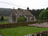
. Byrness's village church features a stained-glass window commemorating the workers who died during the building of Catcleugh Reservoir
nearby. Much of the village was built by the Forestry Commission
to house workers for the extensive forests that surround it. Situated on the Pennine Way
, Byrness has a youth hostel, campsite and other accommodation offering rest and sustenance for weary walkers.
In the seventeenth century Byrness was located in the shieling grounds of the upper Rede valley and there is little or no evidence of permanent post-medieval habitation. By the latter part of the eighteenth century, Hodgson reported that there was a burial ground in the area and the sale of the Lordship by the Howards had resulted in the construction of some farms in the area, such as Catcleugh and Byrness.
The first real evidence of attempts to create a permanent centre of settlement in this part of upper Redesdale came in the 1790s with the erection of the Church of St Francis and also a school by the Rector of Elsdon, the Rev Louis Dutens. The school was only built to house twelve children and gives some indication of the small size of the surrounding agricultural population.
This population remained fairly stable throughout the nineteenth century, but was obviously given a huge increase with the construction of Catcleugh reservoir and the introduction of several hundred workers and their families into this remote rural location. The village for the workers constructed by the Water Company supplied many of the workers' needs. However, aspects of the building operations, such as the narrow gauge railway to Woodburn and the Saturday market held for the dam workers by local tradesmen were of direct benefit to the local people.
When the dam was completed, a small number of workers remained to manage the reservoir, but the next influx new people did not take place until the 1930s. In an effort to assist the long-term unemployed, a number of labour camps to provide industrial training were opened throughout Britain. One of these was built at Byrness as a summer extension camp for the facility at Kielder in North Tynedale and operated as a training centre from 1934 until the Second World War when it was closed down.
It is known that workers from this camp assisted with forestry work as there was clearly a requirement for workers as parts of upper Redesdale was planted. After the war, this work was undertaken by forestry staff who were provided with a purpose built village just north of the church at Byrness.
Dr Thomas Sharp, a highly regarded expert in local authority housing, designed the houses, which are similar to the ones built at Kielder and Stonehaugh. The village has now been sold off to private home-owners as working practices in the forestry industry no longer necessitate a permanent, resident work force. At the same time the school is now housed in a modern building close to the village while the old school is now a private house. The former Byrness farmhouse is now a hotel.
Located in Northumberland
, Byrness the last village in England
before the A68
climbs the Cheviot Hills
to cross Carter Bar
into Scotland. It is situated approximately 60 km (37.3 mi) to the north-west of Newcastle
on the A68
. Byrness's village church features a stained-glass window commemorating the workers who died during the building of Catcleugh Reservoir
nearby. Much of the village was built by the Forestry Commission
to house workers for the extensive forests that surround it. Situated on the Pennine Way
, Byrness has a youth hostel, campsite and other accommodation offering rest and sustenance for weary walkers.
In the seventeenth century Byrness was located in the shieling grounds of the upper Rede valley and there is little or no evidence of permanent post-medieval habitation. By the latter part of the eighteenth century, Hodgson reported that there was a burial ground in the area and the sale of the Lordship by the Howards had resulted in the construction of some farms in the area, such as Catcleugh and Byrness.
The first real evidence of attempts to create a permanent centre of settlement in this part of upper Redesdale came in the 1790s with the erection of the Church of St Francis and also a school by the Rector of Elsdon, the Rev Louis Dutens. The school was only built to house twelve children and gives some indication of the small size of the surrounding agricultural population.
This population remained fairly stable throughout the nineteenth century, but was obviously given a huge increase with the construction of Catcleugh reservoir and the introduction of several hundred workers and their families into this remote rural location. The village for the workers constructed by the Water Company supplied many of the workers' needs. However, aspects of the building operations, such as the narrow gauge railway to Woodburn and the Saturday market held for the dam workers by local tradesmen were of direct benefit to the local people.
When the dam was completed, a small number of workers remained to manage the reservoir, but the next influx new people did not take place until the 1930s. In an effort to assist the long-term unemployed, a number of labour camps to provide industrial training were opened throughout Britain. One of these was built at Byrness as a summer extension camp for the facility at Kielder in North Tynedale and operated as a training centre from 1934 until the Second World War when it was closed down.
It is known that workers from this camp assisted with forestry work as there was clearly a requirement for workers as parts of upper Redesdale was planted. After the war, this work was undertaken by forestry staff who were provided with a purpose built village just north of the church at Byrness.
Dr Thomas Sharp, a highly regarded expert in local authority housing, designed the houses, which are similar to the ones built at Kielder and Stonehaugh. The village has now been sold off to private home-owners as working practices in the forestry industry no longer necessitate a permanent, resident work force. At the same time the school is now housed in a modern building close to the village while the old school is now a private house. The former Byrness farmhouse is now a hotel.

Northumberland
Northumberland is the northernmost ceremonial county and a unitary district in North East England. For Eurostat purposes Northumberland is a NUTS 3 region and is one of three boroughs or unitary districts that comprise the "Northumberland and Tyne and Wear" NUTS 2 region...
, Byrness the last village in England
England
England is a country that is part of the United Kingdom. It shares land borders with Scotland to the north and Wales to the west; the Irish Sea is to the north west, the Celtic Sea to the south west, with the North Sea to the east and the English Channel to the south separating it from continental...
before the A68
A68 road
The A68 is a major road in the United Kingdom, running from Darlington in England to the A720 in Scotland.From Darlington, the road runs north, bypassing Bishop Auckland, and running through West Auckland, Toft Hill and Tow Law, past Consett and Corbridge...
climbs the Cheviot Hills
Cheviot Hills
The Cheviot Hills is a range of rolling hills straddling the England–Scotland border between Northumberland and the Scottish Borders.There is a broad split between the northern and the southern Cheviots...
to cross Carter Bar
Carter Bar
The Carter Bar is the point at which the A68 crosses the England-Scotland border and forms a pass located at the top of Redesdale in the Cheviot Hills at an altitude of . The first sizeable Scottish town is Jedburgh approximately north. Other nearby Scottish towns include Hawick away and Kelso...
into Scotland. It is situated approximately 60 km (37.3 mi) to the north-west of Newcastle
Newcastle upon Tyne
Newcastle upon Tyne is a city and metropolitan borough of Tyne and Wear, in North East England. Historically a part of Northumberland, it is situated on the north bank of the River Tyne...
on the A68
A68 road
The A68 is a major road in the United Kingdom, running from Darlington in England to the A720 in Scotland.From Darlington, the road runs north, bypassing Bishop Auckland, and running through West Auckland, Toft Hill and Tow Law, past Consett and Corbridge...
. Byrness's village church features a stained-glass window commemorating the workers who died during the building of Catcleugh Reservoir
Catcleugh Reservoir
Catcleugh Reservoir is a reservoir in Northumberland, England adjacent to the A68 road; just north of Byrness; and to the south of the border with Scotland.-History:...
nearby. Much of the village was built by the Forestry Commission
Forestry Commission
The Forestry Commission is a non-ministerial government department responsible for forestry in Great Britain. Its mission is to protect and expand Britain's forests and woodlands and increase their value to society and the environment....
to house workers for the extensive forests that surround it. Situated on the Pennine Way
Pennine Way
The Pennine Way is a National Trail in England. The trail runs from Edale, in the northern Derbyshire Peak District, north through the Yorkshire Dales and the Northumberland National Park and ends at Kirk Yetholm, just inside the Scottish border. The path runs along the Pennine hills, sometimes...
, Byrness has a youth hostel, campsite and other accommodation offering rest and sustenance for weary walkers.
In the seventeenth century Byrness was located in the shieling grounds of the upper Rede valley and there is little or no evidence of permanent post-medieval habitation. By the latter part of the eighteenth century, Hodgson reported that there was a burial ground in the area and the sale of the Lordship by the Howards had resulted in the construction of some farms in the area, such as Catcleugh and Byrness.
The first real evidence of attempts to create a permanent centre of settlement in this part of upper Redesdale came in the 1790s with the erection of the Church of St Francis and also a school by the Rector of Elsdon, the Rev Louis Dutens. The school was only built to house twelve children and gives some indication of the small size of the surrounding agricultural population.
This population remained fairly stable throughout the nineteenth century, but was obviously given a huge increase with the construction of Catcleugh reservoir and the introduction of several hundred workers and their families into this remote rural location. The village for the workers constructed by the Water Company supplied many of the workers' needs. However, aspects of the building operations, such as the narrow gauge railway to Woodburn and the Saturday market held for the dam workers by local tradesmen were of direct benefit to the local people.
When the dam was completed, a small number of workers remained to manage the reservoir, but the next influx new people did not take place until the 1930s. In an effort to assist the long-term unemployed, a number of labour camps to provide industrial training were opened throughout Britain. One of these was built at Byrness as a summer extension camp for the facility at Kielder in North Tynedale and operated as a training centre from 1934 until the Second World War when it was closed down.
It is known that workers from this camp assisted with forestry work as there was clearly a requirement for workers as parts of upper Redesdale was planted. After the war, this work was undertaken by forestry staff who were provided with a purpose built village just north of the church at Byrness.
Dr Thomas Sharp, a highly regarded expert in local authority housing, designed the houses, which are similar to the ones built at Kielder and Stonehaugh. The village has now been sold off to private home-owners as working practices in the forestry industry no longer necessitate a permanent, resident work force. At the same time the school is now housed in a modern building close to the village while the old school is now a private house. The former Byrness farmhouse is now a hotel.
Located in Northumberland
Northumberland
Northumberland is the northernmost ceremonial county and a unitary district in North East England. For Eurostat purposes Northumberland is a NUTS 3 region and is one of three boroughs or unitary districts that comprise the "Northumberland and Tyne and Wear" NUTS 2 region...
, Byrness the last village in England
England
England is a country that is part of the United Kingdom. It shares land borders with Scotland to the north and Wales to the west; the Irish Sea is to the north west, the Celtic Sea to the south west, with the North Sea to the east and the English Channel to the south separating it from continental...
before the A68
A68 road
The A68 is a major road in the United Kingdom, running from Darlington in England to the A720 in Scotland.From Darlington, the road runs north, bypassing Bishop Auckland, and running through West Auckland, Toft Hill and Tow Law, past Consett and Corbridge...
climbs the Cheviot Hills
Cheviot Hills
The Cheviot Hills is a range of rolling hills straddling the England–Scotland border between Northumberland and the Scottish Borders.There is a broad split between the northern and the southern Cheviots...
to cross Carter Bar
Carter Bar
The Carter Bar is the point at which the A68 crosses the England-Scotland border and forms a pass located at the top of Redesdale in the Cheviot Hills at an altitude of . The first sizeable Scottish town is Jedburgh approximately north. Other nearby Scottish towns include Hawick away and Kelso...
into Scotland. It is situated approximately 60 km (37.3 mi) to the north-west of Newcastle
Newcastle upon Tyne
Newcastle upon Tyne is a city and metropolitan borough of Tyne and Wear, in North East England. Historically a part of Northumberland, it is situated on the north bank of the River Tyne...
on the A68
A68 road
The A68 is a major road in the United Kingdom, running from Darlington in England to the A720 in Scotland.From Darlington, the road runs north, bypassing Bishop Auckland, and running through West Auckland, Toft Hill and Tow Law, past Consett and Corbridge...
. Byrness's village church features a stained-glass window commemorating the workers who died during the building of Catcleugh Reservoir
Catcleugh Reservoir
Catcleugh Reservoir is a reservoir in Northumberland, England adjacent to the A68 road; just north of Byrness; and to the south of the border with Scotland.-History:...
nearby. Much of the village was built by the Forestry Commission
Forestry Commission
The Forestry Commission is a non-ministerial government department responsible for forestry in Great Britain. Its mission is to protect and expand Britain's forests and woodlands and increase their value to society and the environment....
to house workers for the extensive forests that surround it. Situated on the Pennine Way
Pennine Way
The Pennine Way is a National Trail in England. The trail runs from Edale, in the northern Derbyshire Peak District, north through the Yorkshire Dales and the Northumberland National Park and ends at Kirk Yetholm, just inside the Scottish border. The path runs along the Pennine hills, sometimes...
, Byrness has a youth hostel, campsite and other accommodation offering rest and sustenance for weary walkers.
In the seventeenth century Byrness was located in the shieling grounds of the upper Rede valley and there is little or no evidence of permanent post-medieval habitation. By the latter part of the eighteenth century, Hodgson reported that there was a burial ground in the area and the sale of the Lordship by the Howards had resulted in the construction of some farms in the area, such as Catcleugh and Byrness.
The first real evidence of attempts to create a permanent centre of settlement in this part of upper Redesdale came in the 1790s with the erection of the Church of St Francis and also a school by the Rector of Elsdon, the Rev Louis Dutens. The school was only built to house twelve children and gives some indication of the small size of the surrounding agricultural population.
This population remained fairly stable throughout the nineteenth century, but was obviously given a huge increase with the construction of Catcleugh reservoir and the introduction of several hundred workers and their families into this remote rural location. The village for the workers constructed by the Water Company supplied many of the workers' needs. However, aspects of the building operations, such as the narrow gauge railway to Woodburn and the Saturday market held for the dam workers by local tradesmen were of direct benefit to the local people.
When the dam was completed, a small number of workers remained to manage the reservoir, but the next influx new people did not take place until the 1930s. In an effort to assist the long-term unemployed, a number of labour camps to provide industrial training were opened throughout Britain. One of these was built at Byrness as a summer extension camp for the facility at Kielder in North Tynedale and operated as a training centre from 1934 until the Second World War when it was closed down.
It is known that workers from this camp assisted with forestry work as there was clearly a requirement for workers as parts of upper Redesdale was planted. After the war, this work was undertaken by forestry staff who were provided with a purpose built village just north of the church at Byrness.
Dr Thomas Sharp, a highly regarded expert in local authority housing, designed the houses, which are similar to the ones built at Kielder and Stonehaugh. The village has now been sold off to private home-owners as working practices in the forestry industry no longer necessitate a permanent, resident work force. At the same time the school is now housed in a modern building close to the village while the old school is now a private house. The former Byrness farmhouse is now a hotel.