

53rd Weather Reconnaissance Squadron
Encyclopedia
The 53d Weather Reconnaissance Squadron (AFRC), also known by its nickname, Hurricane Hunters, is a flying unit of the United States Air Force
. Aligned under the 403rd Wing of the Air Force Reserve Command
and based at Keesler Air Force Base
, Mississippi
, it flies aircraft into tropical cyclone
s in the Atlantic Ocean
and the Caribbean
for the specific purpose of directly measuring weather
data in and around those storms.
The Hurricane Hunters of the Air Force Reserve are distinct from those of the NOAA Hurricane Hunters
, based at MacDill AFB, Florida
, a civilian organization that uses a pair of Lockheed WP-3D Orion and a Gulfstream IV-SP aircraft for similar data collection missions.
, which struck Houston, Texas
during World War II
, marked the first intentional meteorological flight into a hurricane. That summer, British pilots being trained as instrument instructor pilots at Bryan Field heard that the school was evacuating its AT-6 Texan
trainers in the face of the oncoming hurricane, and began teasing their instructors about the airworthiness of the aircraft. School commander USAAF
Col.
Joseph B. Duckworth
bet his RAF students that he could safely fly into the storm and return. He took out one of the trainers with 2nd Lt.
Ralph M. O'Hair navigating
and flew it straight into the eye of the storm. After he returned safely, the base's only weather officer, 1st Lt. William H. Jones-Burdick, took over the navigator's seat and Col. Duckworth flew into the storm (now over land) a second time, this time recording their observations and measuring temperatures within the storm. The flights demonstrated that hurricane reconnaissance flights were feasible, and further flights continued on an irregular basis.
The 53d WRS was originally activated in 1944 as the 3rd WRS, at Presque Isle, Maine. Many of its missions were flown from a forward base at Gander, Newfoundland, using B-25 Mitchell
medium bombers. Its original mission was to fly weather tracks between North America and Allied Western Europe. During the 1946 season, the term "Hurricane Hunters" was first used to describe missions of the 53d WRS. From Gander, the squadron moved to New Hampshire; Florida; Kindley Field, Bermuda; Burtonwood Royal Air Force Station, England, with forward basing at Dhahran
, Saudi Arabia
; Bermuda for a short time, and Hunter AFB, Ga. In 1966, now flying the Lockheed WC-130, the 53d WRS once again left the United States, this time for Ramey AFB, Puerto Rico. When Ramey closed in 1973, the Hurricane Hunters relocated to their present location at Keesler AFB, Mississippi.
On September 18, 1953, while based at Kindley Field as the 53d Strategic Reconnaissance Squadron (M), Weather, the squadron suffered its only mission-related loss of an aircraft, a WB-29. Returning to base with a runaway propeller on one engine, the propeller separated from the engine and struck the engine beside it, setting fire to both the engine and wing. The pilot ordered an immediate bailout, but only nine of the 15-man crew escaped the aircraft before it crashed.
In 1976 the 815th Tactical Airlift Squadron
of the Air Force Reserve, also based at Keesler, was redesignated the 815th Weather Squadron "Storm Trackers" and served as an associate squadron to the 53d until 1987, when the 815th reverted to a tactical airlift unit. The Regular Air Force 53d WRS was deactivated in June 1991 for budgetary reasons and its mission assumed by the 815th TAS, which continued its airlift role as well. On November 1, 1993, the 53d WRS was reactivated as an Air Force Reserve squadron to take over the weather reconnissance mission from the 815th AS.
The WC-130H airframes flown by the 53d WRS were originally built in 1964-65 as C-130Es. 1992's Hurricane Andrew
demonstrated a need for upgraded models to continue the mission, and funding for ten replacements was authorized by Congress in FY1998. On October 11, 1999, the 53d WRS received its first WC-130J, and flew its first hurricane mission in the new model on November 16, into Hurricane Lenny
. Problems with the new model, primarily damage to its composite material
6-bladed propellers from hail and ice and a lack of sensitivity in its color radar images, delayed its Initial Operational Capability until just before the 2005 hurricane season. The propeller problem was overcome by bonding a metal sleeve to the leading edge of each blade and the radar issue by changes in the radar software coding.
While in conversion to the new airframe, the unit continued its mission of aerial weather reconnaissance and added a new weather-related mission type in 2003, using the WC-130Js to drop buoys ahead of impending tropical storms. In 2004, the unit started training to support tactical airlift missions in addition to its weather mission.
The landfall of Hurricane Katrina
on August 29, 2005 caused devastating damage to Keesler Air Force Base
. The equipment and personnel of the squadron were flying out of Dobbins Air Reserve Base
near Atlanta, Georgia
when the hurricane struck and never missed a tasked mission.
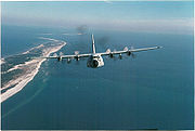
 The 53d Weather Reconnaissance Squadron flies missions into hurricanes
and weather systems for research purposes and observation. Although satellite
data has revolutionized weather forecast
ers' ability to detect early signs of tropical cyclones before they form, there are still many important tasks for which this information is not suitable. Satellites cannot determine the interior barometric pressure of a hurricane, nor provide accurate wind speed information. These data are needed to accurately predict hurricane development and movement. Because satellites cannot collect the data and ships are too slow and vulnerable, the only viable way to collect this information is with aircraft. Meteorological parameters measured are:
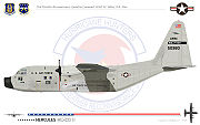
The 53d WRS is equipped with ten pallet-instrumented WC-130J aircraft to collect the required meteorological data. The area of responsibility for the "Hurricane Hunters" is midway through the Atlantic Ocean to the Hawaiian Islands
, although they have also been tasked to fly into typhoons in the Pacific Ocean
on occasion, as well as gather data in winter storms. The Hurricane Hunters are tasked to support 24 hour a day continuous operations with the ability to fly up to 3 storms at a time with a response time of 16 hours. This necessitates a mission organization of ten full-time aircrews and ten part-time. Crews train twice monthly at Keesler AFB and fly weather recon missions when available. The WC-130J employs a five person crew element of a pilot, co-pilot, navigator, aerial reconnaissance weather officer (ARWO), and a weather loadmaster/dropsonde operator.
Since 1969, the 53d WRS also performs winter storm weather reconnaissance off both coasts of the United States between November 1 and April 15 in support of the National Centers for Environmental Prediction
. These missions are flown at the WC-130's service ceiling
of 30000 ft (9,144 m), which subjects them to turbulence, lightning and icing. The crews collect data ahead of weather systems, dropping weather buoy
s along their routes, before they move off the eastern seaboard to help determine if the conditions are right to intensify into Nor'easter
blizzards. In 1997 and 1998, the Hurricane Hunters also flew winter storms in the Gulf of Alaska
. The predetermined tracks are six to eleven hours in duration, with one to three missions flown per major winter storm event.
(a division of the National Weather Service
located in Miami, Florida
, that tracks hurricanes to provide early warning service for Atlantic basin
storms) sends the 53d WRS to investigate if the winds are blowing in a counterclockwise rotation, indicating a "closed system". This mission is flown at an altitude of 500 ft (152.4 m) - 1500 ft (457.2 m) above the ocean surface. The ARWO aboard the mission WC-130 continuously monitors ocean waves to determine wind speed and direction. The low-level wind and pressure fields provide an accurate picture for NHC forecasters. Once NHC determines that there is circulation within the disturbance, the mission becomes a "fix" mission.
During the "fix" mission, the ARWO directs the aircraft to the true center of the storm. In order to make a reliable evaluation of the size and configuration of the storm, the crew flies through it using an "alpha pattern" consisting of intercardinal headings with legs 105 nautical miles (194.5 km) in length. The alpha pattern is repeated twice during the mission. Flight weather data is continuously collected and sent directly to the NHC by satellite communications. Since the WC-130J is not equipped for aerial refueling, the alpha pattern continues until minimum fuel reserve is reached, or until the NHC has received all the data it requires.
Major hurricanes (category 3 or above) are entered at approximately 10000 ft (3,048 m) altitude. While penetrating the eyewall
, a dropsonde is released to determine the maximum winds at the surface and a second dropsonde is released in the eye
to detect the lowest pressure at the surface. After exiting the eye, the ARWO creates a Vortex Data Message that includes the precise latitude and longitude of the storm center as well as its maximum winds, maximum temperature, and minimum sea level pressure. The average duration of a "Hurricane Hunter" mission is eleven hours.


United States Air Force
The United States Air Force is the aerial warfare service branch of the United States Armed Forces and one of the American uniformed services. Initially part of the United States Army, the USAF was formed as a separate branch of the military on September 18, 1947 under the National Security Act of...
. Aligned under the 403rd Wing of the Air Force Reserve Command
Air Force Reserve Command
The Air Force Reserve Command is a major command of the U.S. Air Force with its headquarters at Robins AFB, Georgia.It stood up as a major command of the Air Force on 17 February 1997....
and based at Keesler Air Force Base
Keesler Air Force Base
Keesler Air Force Base is a United States Air Force base located in Biloxi, a city in Harrison County, Mississippi, United States. The base is named in honor of aviator 2d Lt Samuel Reeves Keesler, Jr., a Mississippi native killed in France in First World War.-Units:The base is home of...
, Mississippi
Mississippi
Mississippi is a U.S. state located in the Southern United States. Jackson is the state capital and largest city. The name of the state derives from the Mississippi River, which flows along its western boundary, whose name comes from the Ojibwe word misi-ziibi...
, it flies aircraft into tropical cyclone
Tropical cyclone
A tropical cyclone is a storm system characterized by a large low-pressure center and numerous thunderstorms that produce strong winds and heavy rain. Tropical cyclones strengthen when water evaporated from the ocean is released as the saturated air rises, resulting in condensation of water vapor...
s in the Atlantic Ocean
Atlantic Ocean
The Atlantic Ocean is the second-largest of the world's oceanic divisions. With a total area of about , it covers approximately 20% of the Earth's surface and about 26% of its water surface area...
and the Caribbean
Caribbean
The Caribbean is a crescent-shaped group of islands more than 2,000 miles long separating the Gulf of Mexico and the Caribbean Sea, to the west and south, from the Atlantic Ocean, to the east and north...
for the specific purpose of directly measuring weather
Weather
Weather is the state of the atmosphere, to the degree that it is hot or cold, wet or dry, calm or stormy, clear or cloudy. Most weather phenomena occur in the troposphere, just below the stratosphere. Weather refers, generally, to day-to-day temperature and precipitation activity, whereas climate...
data in and around those storms.
The Hurricane Hunters of the Air Force Reserve are distinct from those of the NOAA Hurricane Hunters
NOAA Hurricane Hunters
The NOAA Hurricane Hunters work under the Aircraft Operations Center , located on MacDill Air Force Base in Tampa, Florida. The Aircraft Operations Center is under the Office of Marine and Aviation Operations , which is a branch of the National Oceanic and Atmospheric Administration . NOAA is part...
, based at MacDill AFB, Florida
Florida
Florida is a state in the southeastern United States, located on the nation's Atlantic and Gulf coasts. It is bordered to the west by the Gulf of Mexico, to the north by Alabama and Georgia and to the east by the Atlantic Ocean. With a population of 18,801,310 as measured by the 2010 census, it...
, a civilian organization that uses a pair of Lockheed WP-3D Orion and a Gulfstream IV-SP aircraft for similar data collection missions.
Lineage
- Constituted 3d Weather Reconnaissance Squadron, Air Route, Medium on 7 Aug 1944
- Activated on 31 Aug 1944
- Redesignated 3d Reconnaissance Squadron, Weather, Heavy on 26 Jan 1945
- Redesignated 53d Reconnaissance Squadron, Long Range, Weather on 15 Jun 1945
- Redesignated 53d Reconnaissance Squadron, Very Long Range, Weather on 27 Nov 1945
- Inactivated on 15 Oct 1947
- Redesignated 53d Strategic Reconnaissance Squadron, Medium, Weather on 22 Jan 1951
- Activated on 21 Feb 1951
- Redesignated 53d Weather Reconnaissance Squadron on 15 Feb 1954
- Discontinued on 18 Mar 1960
- Organized on 8 Jan 1962
- Inactivated on 30 Jun 1991
- Activated in the Reserve on 1 Nov 1993
Assignments
- North Atlantic Division ATC, 31 Aug 1944
- Air Transport CommandAir Transport CommandAir Transport Command is an inactive United States Air Force unit. Its mission was to meet the urgent demand for the speedy reinforcement of the United States' military bases worldwide during World War II, using an air supply system to supplement surface transport...
, 12 Jan 1945 - 311th Photographic (later, 311th Reconnaissance) Wing311th Air DivisionThe 311th Air Division is an inactive United States Air Force organization. Its last assignment was with Strategic Air Command, being stationed at Forbes Air Force Base, Kansas...
, 15 Feb 1945 - Air Transport Command, 13 Mar 1946
- Air Weather Service, 20 Mar 1946-15 Oct 1947
- 2108th Air Weather Group]], 21 Feb 1951
- Air Weather Service, 2 May 1951
- 9th Weather Group, 20 Apr 1953
- 2058 Air Weather Wing, 25 Nov 1953
- 2d Weather Wing, 8 Feb 1954-18 Mar 1960
- 9th Weather Reconnaissance Group, 8 Jan 1962
- 9th Weather Reconnaissance Wing9th Weather Reconnaissance WingThe 9th Weather Reconnaissance Wing is an inactive United States Air Force organization. Its last assignment was with the Air Weather Service, being stationed at McClellan Air Force Base, California. It was inactivated on 31 August 1975.- History :...
, 1 Jul 1965 - 41th Rescue and Weather Reconnaissance Wing, 1 Sep 1975
- Air Rescue ServiceAir Rescue ServiceThe Air Rescue Service is a disestablished organization in the United States Air Force. Previously a subcommand of the Military Air Transport Service , a USAF major command , ARS was redesignated as the Aerospace Rescue and Recovery Service on 1 Jan 1966 when MATS was redesignated as the Military...
, 1 Aug 1989-30 Jun 1991 - 403d Operations Group403d Wing403d Wing is a unit of the United States Air Force assigned to the Air Force Reserve Command. It is located at Keesler Air Force Base in Mississippi, and employs a military manning authorization of more than 1,400 reservists, including some 250 full-time air reserve technicians.403d Wing performs...
, 1 Nov 1993-
Stations
- Presque Isle AAFldPresque Isle Air Force BasePresque Isle Air Force Base is a former United States Air Force base, located in the city of Presque Isle, Maine.-History:Presque Isle Air Force Base was originally built in 1930 by the Civilian Conservation Corps as Presque Isle Airport, a commercial airport located west of the "business center."...
, MaineMaineMaine is a state in the New England region of the northeastern United States, bordered by the Atlantic Ocean to the east and south, New Hampshire to the west, and the Canadian provinces of Quebec to the northwest and New Brunswick to the northeast. Maine is both the northernmost and easternmost...
, 31 Aug 1944 - Grenier Field, New HampshireNew HampshireNew Hampshire is a state in the New England region of the northeastern United States of America. The state was named after the southern English county of Hampshire. It is bordered by Massachusetts to the south, Vermont to the west, Maine and the Atlantic Ocean to the east, and the Canadian...
, 9 Nov 1944 - Morrison Field, FloridaFloridaFlorida is a state in the southeastern United States, located on the nation's Atlantic and Gulf coasts. It is bordered to the west by the Gulf of Mexico, to the north by Alabama and Georgia and to the east by the Atlantic Ocean. With a population of 18,801,310 as measured by the 2010 census, it...
, 8 Nov 1946-21 Jul 1947 - Kindley FieldKindley Air Force BaseKindley Air Force Base was a United States Air Force base in Bermuda from 1948–1970, having been operated from 1943 to 1948 by the United States Army Air Force as Kindley Field.-World War II:...
, BermudaBermudaBermuda is a British overseas territory in the North Atlantic Ocean. Located off the east coast of the United States, its nearest landmass is Cape Hatteras, North Carolina, about to the west-northwest. It is about south of Halifax, Nova Scotia, Canada, and northeast of Miami, Florida...
, 17 Aug-15 Oct 1947 - Kindley AFB, Bermuda, 21 Feb 1951-5 Nov 1953
- Burtonwood Air Depot (later, RAF BurtonwoodRAF BurtonwoodRAF Burtonwood was a Royal Air Force station in England, 2 miles north-west of Warrington, Lancashire. During World War II and the Cold War it was used by the United States Air Force and was also known as USAAF station 590.- Overview :...
), EnglandEnglandEngland is a country that is part of the United Kingdom. It shares land borders with Scotland to the north and Wales to the west; the Irish Sea is to the north west, the Celtic Sea to the south west, with the North Sea to the east and the English Channel to the south separating it from continental...
, 7 Nov 1953
- RAF AlconburyRAF AlconburyRAF Alconbury is an active Royal Air Force station in Cambridgeshire, England. The airfield is adjacent to the Stukeleys [Great and Little] and located about northwest of Huntingdon; about north of London....
, England, 25 Apr 1959 - RAF MildenhallRAF MildenhallRAF Mildenhall is a Royal Air Force station located at Mildenhall in Suffolk, England. Despite its status as an RAF station, it primarily supports United States Air Force operations and is currently the home of the 100th Air Refueling Wing...
, England, 10 Aug 1959-18 Mar 1960 - Kindley AFB, Bermuda, 8 Jan 1962-1 Jul 1963
- Hunter AFB, GeorgiaGeorgia (U.S. state)Georgia is a state located in the southeastern United States. It was established in 1732, the last of the original Thirteen Colonies. The state is named after King George II of Great Britain. Georgia was the fourth state to ratify the United States Constitution, on January 2, 1788...
, 31 Aug 1963 - Ramey AFB, Puerto RicoPuerto RicoPuerto Rico , officially the Commonwealth of Puerto Rico , is an unincorporated territory of the United States, located in the northeastern Caribbean, east of the Dominican Republic and west of both the United States Virgin Islands and the British Virgin Islands.Puerto Rico comprises an...
, 15 Jun 1966 - Keesler AFB, MississippiMississippiMississippi is a U.S. state located in the Southern United States. Jackson is the state capital and largest city. The name of the state derives from the Mississippi River, which flows along its western boundary, whose name comes from the Ojibwe word misi-ziibi...
, 1 Jul 1973-30 Jun 1991, 1 Nov 1993-
Aircraft operated
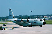
- WC-130J Hercules, (1999–present)
- WC-130A/B/E/H Hercules, (1965–2006)
- WB-47E Stratojet, (1963–1969)
- WB-50D Superfortress, (1956–1960, 1962-1963)
- WB-29 Superfortress, (1951–1956)
- B-29 SuperfortressB-29 SuperfortressThe B-29 Superfortress is a four-engine propeller-driven heavy bomber designed by Boeing that was flown primarily by the United States Air Forces in late-World War II and through the Korean War. The B-29 was one of the largest aircraft to see service during World War II...
, (1946–1947) - RB-17/TB-17 Flying FortressB-17 Flying Fortress variantsThe following is an extensive catalogue of the variants and specific unique elements of each variant and/or design stage of the Boeing B-17 Flying Fortress heavy bomber...
, (1945–1947) - B-25/WB-25D MitchellB-25 MitchellThe North American B-25 Mitchell was an American twin-engined medium bomber manufactured by North American Aviation. It was used by many Allied air forces, in every theater of World War II, as well as many other air forces after the war ended, and saw service across four decades.The B-25 was named...
, (1944, 1946–1947)
Operational history
The 1943 Surprise Hurricane1943 Surprise Hurricane
The 1943 Surprise Hurricane struck the Houston, Texas area on July 27, 1943. While not a major hurricane, the storm was described as the worst since the 1915 hurricane, which tested the newly constructed seawall at Galveston.-Meteorological history:...
, which struck Houston, Texas
Houston, Texas
Houston is the fourth-largest city in the United States, and the largest city in the state of Texas. According to the 2010 U.S. Census, the city had a population of 2.1 million people within an area of . Houston is the seat of Harris County and the economic center of , which is the ...
during World War II
World War II
World War II, or the Second World War , was a global conflict lasting from 1939 to 1945, involving most of the world's nations—including all of the great powers—eventually forming two opposing military alliances: the Allies and the Axis...
, marked the first intentional meteorological flight into a hurricane. That summer, British pilots being trained as instrument instructor pilots at Bryan Field heard that the school was evacuating its AT-6 Texan
T-6 Texan
The North American Aviation T-6 Texan was a single-engine advanced trainer aircraft used to train pilots of the United States Army Air Forces, United States Navy, Royal Air Force and other air forces of the British Commonwealth during World War II and into the 1950s...
trainers in the face of the oncoming hurricane, and began teasing their instructors about the airworthiness of the aircraft. School commander USAAF
United States Army Air Forces
The United States Army Air Forces was the military aviation arm of the United States of America during and immediately after World War II, and the direct predecessor of the United States Air Force....
Col.
Colonel
Colonel , abbreviated Col or COL, is a military rank of a senior commissioned officer. It or a corresponding rank exists in most armies and in many air forces; the naval equivalent rank is generally "Captain". It is also used in some police forces and other paramilitary rank structures...
Joseph B. Duckworth
Joseph Duckworth
Joseph B. Duckworth was a colonel in the United States Air Force, and was regarded as the "father" of modern instrument flight...
bet his RAF students that he could safely fly into the storm and return. He took out one of the trainers with 2nd Lt.
Lieutenant
A lieutenant is a junior commissioned officer in many nations' armed forces. Typically, the rank of lieutenant in naval usage, while still a junior officer rank, is senior to the army rank...
Ralph M. O'Hair navigating
Navigation
Navigation is the process of monitoring and controlling the movement of a craft or vehicle from one place to another. It is also the term of art used for the specialized knowledge used by navigators to perform navigation tasks...
and flew it straight into the eye of the storm. After he returned safely, the base's only weather officer, 1st Lt. William H. Jones-Burdick, took over the navigator's seat and Col. Duckworth flew into the storm (now over land) a second time, this time recording their observations and measuring temperatures within the storm. The flights demonstrated that hurricane reconnaissance flights were feasible, and further flights continued on an irregular basis.
The 53d WRS was originally activated in 1944 as the 3rd WRS, at Presque Isle, Maine. Many of its missions were flown from a forward base at Gander, Newfoundland, using B-25 Mitchell
B-25 Mitchell
The North American B-25 Mitchell was an American twin-engined medium bomber manufactured by North American Aviation. It was used by many Allied air forces, in every theater of World War II, as well as many other air forces after the war ended, and saw service across four decades.The B-25 was named...
medium bombers. Its original mission was to fly weather tracks between North America and Allied Western Europe. During the 1946 season, the term "Hurricane Hunters" was first used to describe missions of the 53d WRS. From Gander, the squadron moved to New Hampshire; Florida; Kindley Field, Bermuda; Burtonwood Royal Air Force Station, England, with forward basing at Dhahran
Dhahran
Dhahran is a city located in Saudi Arabia's Eastern Province, and is a major administrative center for the Saudi oil industry. Large oil reserves were first identified in the Dhahran area in 1931, and in 1935 Standard Oil of California drilled the first commercially viable oil well...
, Saudi Arabia
Saudi Arabia
The Kingdom of Saudi Arabia , commonly known in British English as Saudi Arabia and in Arabic as as-Sa‘ūdiyyah , is the largest state in Western Asia by land area, constituting the bulk of the Arabian Peninsula, and the second-largest in the Arab World...
; Bermuda for a short time, and Hunter AFB, Ga. In 1966, now flying the Lockheed WC-130, the 53d WRS once again left the United States, this time for Ramey AFB, Puerto Rico. When Ramey closed in 1973, the Hurricane Hunters relocated to their present location at Keesler AFB, Mississippi.
On September 18, 1953, while based at Kindley Field as the 53d Strategic Reconnaissance Squadron (M), Weather, the squadron suffered its only mission-related loss of an aircraft, a WB-29. Returning to base with a runaway propeller on one engine, the propeller separated from the engine and struck the engine beside it, setting fire to both the engine and wing. The pilot ordered an immediate bailout, but only nine of the 15-man crew escaped the aircraft before it crashed.
In 1976 the 815th Tactical Airlift Squadron
815th Airlift Squadron
The 815th Airlift Squadron is part of the 403d Wing at Keesler Air Force Base, Mississippi. It operates C-130J Hercules aircraft providing global airlfit....
of the Air Force Reserve, also based at Keesler, was redesignated the 815th Weather Squadron "Storm Trackers" and served as an associate squadron to the 53d until 1987, when the 815th reverted to a tactical airlift unit. The Regular Air Force 53d WRS was deactivated in June 1991 for budgetary reasons and its mission assumed by the 815th TAS, which continued its airlift role as well. On November 1, 1993, the 53d WRS was reactivated as an Air Force Reserve squadron to take over the weather reconnissance mission from the 815th AS.
The WC-130H airframes flown by the 53d WRS were originally built in 1964-65 as C-130Es. 1992's Hurricane Andrew
Hurricane Andrew
Hurricane Andrew was the third Category 5 hurricane to make landfall in the United States, after the Labor Day Hurricane of 1935 and Hurricane Camille in 1969. Andrew was the first named storm and only major hurricane of the otherwise inactive 1992 Atlantic hurricane season...
demonstrated a need for upgraded models to continue the mission, and funding for ten replacements was authorized by Congress in FY1998. On October 11, 1999, the 53d WRS received its first WC-130J, and flew its first hurricane mission in the new model on November 16, into Hurricane Lenny
Hurricane Lenny
Hurricane Lenny was the strongest November Atlantic hurricane on record. It was the twelfth tropical storm, eighth hurricane, and record-breaking fifth Category 4 hurricane in the 1999 Atlantic hurricane season. Lenny formed on November 13 in the western Caribbean Sea, and maintained an...
. Problems with the new model, primarily damage to its composite material
Composite material
Composite materials, often shortened to composites or called composition materials, are engineered or naturally occurring materials made from two or more constituent materials with significantly different physical or chemical properties which remain separate and distinct at the macroscopic or...
6-bladed propellers from hail and ice and a lack of sensitivity in its color radar images, delayed its Initial Operational Capability until just before the 2005 hurricane season. The propeller problem was overcome by bonding a metal sleeve to the leading edge of each blade and the radar issue by changes in the radar software coding.
While in conversion to the new airframe, the unit continued its mission of aerial weather reconnaissance and added a new weather-related mission type in 2003, using the WC-130Js to drop buoys ahead of impending tropical storms. In 2004, the unit started training to support tactical airlift missions in addition to its weather mission.
The landfall of Hurricane Katrina
Hurricane Katrina
Hurricane Katrina of the 2005 Atlantic hurricane season was a powerful Atlantic hurricane. It is the costliest natural disaster, as well as one of the five deadliest hurricanes, in the history of the United States. Among recorded Atlantic hurricanes, it was the sixth strongest overall...
on August 29, 2005 caused devastating damage to Keesler Air Force Base
Keesler Air Force Base
Keesler Air Force Base is a United States Air Force base located in Biloxi, a city in Harrison County, Mississippi, United States. The base is named in honor of aviator 2d Lt Samuel Reeves Keesler, Jr., a Mississippi native killed in France in First World War.-Units:The base is home of...
. The equipment and personnel of the squadron were flying out of Dobbins Air Reserve Base
Dobbins Air Reserve Base
Dobbins Air Reserve Base or Dobbins ARB is a United States air reserve base located in Marietta, Georgia, a suburb about northwest of Atlanta. It was named in honor of Captain Charles M. Dobbins, a World War II C-47 pilot who died near Sicily...
near Atlanta, Georgia
Atlanta, Georgia
Atlanta is the capital and most populous city in the U.S. state of Georgia. According to the 2010 census, Atlanta's population is 420,003. Atlanta is the cultural and economic center of the Atlanta metropolitan area, which is home to 5,268,860 people and is the ninth largest metropolitan area in...
when the hurricane struck and never missed a tasked mission.
Hurricane Hunter mission
Tropical cyclone
A tropical cyclone is a storm system characterized by a large low-pressure center and numerous thunderstorms that produce strong winds and heavy rain. Tropical cyclones strengthen when water evaporated from the ocean is released as the saturated air rises, resulting in condensation of water vapor...
and weather systems for research purposes and observation. Although satellite
Satellite
In the context of spaceflight, a satellite is an object which has been placed into orbit by human endeavour. Such objects are sometimes called artificial satellites to distinguish them from natural satellites such as the Moon....
data has revolutionized weather forecast
Weather forecasting
Weather forecasting is the application of science and technology to predict the state of the atmosphere for a given location. Human beings have attempted to predict the weather informally for millennia, and formally since the nineteenth century...
ers' ability to detect early signs of tropical cyclones before they form, there are still many important tasks for which this information is not suitable. Satellites cannot determine the interior barometric pressure of a hurricane, nor provide accurate wind speed information. These data are needed to accurately predict hurricane development and movement. Because satellites cannot collect the data and ships are too slow and vulnerable, the only viable way to collect this information is with aircraft. Meteorological parameters measured are:
- exact geographical position of the storm center at flight level and relative position of the center at the surface,
- sea-level atmospheric pressure of the storm center determined by dropsondeDropsondeA dropsonde is a weather reconnaissance device created by the National Center for Atmospheric Research , designed to be dropped from an aircraft at altitude to more accurately measure tropical storm conditions as the device falls to the surface...
or extrapolation from within 1500 ft (457.2 m) of the sea surface, - minimum pressure at altitudes of 5000 ft (1,524 m) or 10000 ft (3,048 m),
- wind profile data at flight level,
- temperature profile at flight level, and
- dew point profile at flight level.
The 53d WRS is equipped with ten pallet-instrumented WC-130J aircraft to collect the required meteorological data. The area of responsibility for the "Hurricane Hunters" is midway through the Atlantic Ocean to the Hawaiian Islands
Hawaiian Islands
The Hawaiian Islands are an archipelago of eight major islands, several atolls, numerous smaller islets, and undersea seamounts in the North Pacific Ocean, extending some 1,500 miles from the island of Hawaii in the south to northernmost Kure Atoll...
, although they have also been tasked to fly into typhoons in the Pacific Ocean
Pacific Ocean
The Pacific Ocean is the largest of the Earth's oceanic divisions. It extends from the Arctic in the north to the Southern Ocean in the south, bounded by Asia and Australia in the west, and the Americas in the east.At 165.2 million square kilometres in area, this largest division of the World...
on occasion, as well as gather data in winter storms. The Hurricane Hunters are tasked to support 24 hour a day continuous operations with the ability to fly up to 3 storms at a time with a response time of 16 hours. This necessitates a mission organization of ten full-time aircrews and ten part-time. Crews train twice monthly at Keesler AFB and fly weather recon missions when available. The WC-130J employs a five person crew element of a pilot, co-pilot, navigator, aerial reconnaissance weather officer (ARWO), and a weather loadmaster/dropsonde operator.
Since 1969, the 53d WRS also performs winter storm weather reconnaissance off both coasts of the United States between November 1 and April 15 in support of the National Centers for Environmental Prediction
National Centers for Environmental Prediction
The United States National Centers for Environmental Prediction delivers national and global weather, water, climate and space weather guidance, forecasts, warnings and analyses to its Partners and External User Communities...
. These missions are flown at the WC-130's service ceiling
Service ceiling
With respect to aircraft, a ceiling is the maximum density altitude an aircraft can reach under a set of conditions.The word ceiling can also refer to the height of the lowest obscuring cloud layer above the ground.-Service ceiling:...
of 30000 ft (9,144 m), which subjects them to turbulence, lightning and icing. The crews collect data ahead of weather systems, dropping weather buoy
Weather buoy
Weather buoys are instruments which collect weather and ocean data within the world's oceans, as well as aiding during emergency response to chemical spills, legal proceedings, and engineering design. Moored buoys have been in used since 1951, while drifting buoys have been used since 1979...
s along their routes, before they move off the eastern seaboard to help determine if the conditions are right to intensify into Nor'easter
Nor'easter
A nor'easter is a type of macro-scale storm along the East Coast of the United States and Atlantic Canada, so named because the storm travels to the northeast from the south and the winds come from the northeast, especially in the coastal areas of the Northeastern United States and Atlantic Canada...
blizzards. In 1997 and 1998, the Hurricane Hunters also flew winter storms in the Gulf of Alaska
Gulf of Alaska
The Gulf of Alaska is an arm of the Pacific Ocean defined by the curve of the southern coast of Alaska, stretching from the Alaska Peninsula and Kodiak Island in the west to the Alexander Archipelago in the east, where Glacier Bay and the Inside Passage are found.The entire shoreline of the Gulf is...
. The predetermined tracks are six to eleven hours in duration, with one to three missions flown per major winter storm event.
Hurricane mission profile
When a storm is beginning to form, the National Hurricane CenterNational Hurricane Center
The National Hurricane Center , located at Florida International University in Miami, Florida, is the division of the National Weather Service responsible for tracking and predicting weather systems within the tropics between the Prime Meridian and the 140th meridian west poleward to the 30th...
(a division of the National Weather Service
National Weather Service
The National Weather Service , once known as the Weather Bureau, is one of the six scientific agencies that make up the National Oceanic and Atmospheric Administration of the United States government...
located in Miami, Florida
Miami, Florida
Miami is a city located on the Atlantic coast in southeastern Florida and the county seat of Miami-Dade County, the most populous county in Florida and the eighth-most populous county in the United States with a population of 2,500,625...
, that tracks hurricanes to provide early warning service for Atlantic basin
Atlantic Basin
The Atlantic Basin is the Atlantic Ocean.Atlantic Basin may also refer to:* Atlantic Basin Iron Works, an ironworks that operated in Brooklyn, New York, in the early to mid-20th century...
storms) sends the 53d WRS to investigate if the winds are blowing in a counterclockwise rotation, indicating a "closed system". This mission is flown at an altitude of 500 ft (152.4 m) - 1500 ft (457.2 m) above the ocean surface. The ARWO aboard the mission WC-130 continuously monitors ocean waves to determine wind speed and direction. The low-level wind and pressure fields provide an accurate picture for NHC forecasters. Once NHC determines that there is circulation within the disturbance, the mission becomes a "fix" mission.
During the "fix" mission, the ARWO directs the aircraft to the true center of the storm. In order to make a reliable evaluation of the size and configuration of the storm, the crew flies through it using an "alpha pattern" consisting of intercardinal headings with legs 105 nautical miles (194.5 km) in length. The alpha pattern is repeated twice during the mission. Flight weather data is continuously collected and sent directly to the NHC by satellite communications. Since the WC-130J is not equipped for aerial refueling, the alpha pattern continues until minimum fuel reserve is reached, or until the NHC has received all the data it requires.
Major hurricanes (category 3 or above) are entered at approximately 10000 ft (3,048 m) altitude. While penetrating the eyewall
Eye (cyclone)
The eye is a region of mostly calm weather found at the center of strong tropical cyclones. The eye of a storm is a roughly circular area and typically 30–65 km in diameter. It is surrounded by the eyewall, a ring of towering thunderstorms where the second most severe weather of a cyclone...
, a dropsonde is released to determine the maximum winds at the surface and a second dropsonde is released in the eye
Eye (cyclone)
The eye is a region of mostly calm weather found at the center of strong tropical cyclones. The eye of a storm is a roughly circular area and typically 30–65 km in diameter. It is surrounded by the eyewall, a ring of towering thunderstorms where the second most severe weather of a cyclone...
to detect the lowest pressure at the surface. After exiting the eye, the ARWO creates a Vortex Data Message that includes the precise latitude and longitude of the storm center as well as its maximum winds, maximum temperature, and minimum sea level pressure. The average duration of a "Hurricane Hunter" mission is eleven hours.
Decorations
- Meritorious Unit CommendationMeritorious Unit CommendationThe Meritorious Unit Commendation is a mid-level unit award of the United States military which is awarded to any military command which displays exceptionally meritorious conduct in the performance of outstanding service, heroic deeds, or valorous actions....
:
- 23 May-31 Oct 1945
- Outstanding Unit AwardOutstanding Unit AwardThe Air Force Outstanding Unit Award is an award of the United States Air Force which was first created in 1954. The award is presented as a ribbon to any command of the U.S...
s:
- 1 Dec 1958-30 Sep 1959
- 1 Jul 1967-30 Jun 1968
- 1 Jan-31 Dec 1971
- 1 Sep 1975-1 May 1977
- 16 Jul 1977-16 Jul 1979
- 17 Jul 1979-15 Jun 1981
- 1 Apr 1984-31 Mar 1986
- 1 Apr 1986-31 Mar 1988
- [1 Nov 1993]-30 Apr 1994
- 1 May 1994-30 Apr 1996
- 1 May 1996-31 Aug 1997
See also
- Tropical cycloneTropical cycloneA tropical cyclone is a storm system characterized by a large low-pressure center and numerous thunderstorms that produce strong winds and heavy rain. Tropical cyclones strengthen when water evaporated from the ocean is released as the saturated air rises, resulting in condensation of water vapor...
- NOAA Hurricane HuntersNOAA Hurricane HuntersThe NOAA Hurricane Hunters work under the Aircraft Operations Center , located on MacDill Air Force Base in Tampa, Florida. The Aircraft Operations Center is under the Office of Marine and Aviation Operations , which is a branch of the National Oceanic and Atmospheric Administration . NOAA is part...
External links
- 403rd Wing official website
- Aerial Reconnaissance Weather Officer Equipment description
- 53d WRS image gallery (USAF)
- Hurricane Hunters Association homepage
- AF Reserve Hurricane Hunters, Facebook page maintained by 403rd Wing Public Affairs Office
- Air Weather Reconnaissance Association homepage
- Whiskey-Charlie!, a history of WC-130 weather aircraft
- Why and how people fly into hurricanes - USA Today - sidebar, "Fatal flights"