

NOAA Hurricane Hunters
Encyclopedia
The NOAA Hurricane Hunters work under the Aircraft Operations Center
Aircraft Operations Center
The Aircraft Operations Center is the main base for the approximately 15 aircraft of the National Oceanic and Atmospheric Administration of the United States government.It is the home base of the NOAA Hurricane Hunters....
(AOC), located on MacDill Air Force Base
MacDill Air Force Base
MacDill Air Force Base is an active United States Air Force base located approximately south-southwest of downtown Tampa, Florida...
in Tampa, Florida
Tampa, Florida
Tampa is a city in the U.S. state of Florida. It serves as the county seat for Hillsborough County. Tampa is located on the west coast of Florida. The population of Tampa in 2010 was 335,709....
. The Aircraft Operations Center is under the Office of Marine and Aviation Operations (OMAO), which is a branch of the National Oceanic and Atmospheric Administration
National Oceanic and Atmospheric Administration
The National Oceanic and Atmospheric Administration , pronounced , like "noah", is a scientific agency within the United States Department of Commerce focused on the conditions of the oceans and the atmosphere...
(NOAA). NOAA is part of the Department of Commerce
United States Department of Commerce
The United States Department of Commerce is the Cabinet department of the United States government concerned with promoting economic growth. It was originally created as the United States Department of Commerce and Labor on February 14, 1903...
. The AOC has resided at MacDill AFB since January 1993.
About
The NOAA Hurricane Hunters conduct research using special aircraft in order to support NOAA's mission of predicting changes in the Earth's environment and managing coastal and marine resources. AOC crews fly through hurricanes to help forecasters and scientists gather both operational and research data. In addition, the crews do a number of other research projects - including ocean wind studies, winter storm research, thunderstorm research, coastal erosion, and air chemistry flights to name a few.Currently, AOC staff members are working to bring all of their post flight data collected during missions to the World Wide Web
World Wide Web
The World Wide Web is a system of interlinked hypertext documents accessed via the Internet...
. When the website is completed it will be posted here.
Mission
The OMAO mission states:"To safely and efficiently operate NOAA ships and aircraft, incorporate emerging data acquisition technologies, and provide a specialized professional team responsive to NOAA programs."
The OMAO vision states:
"To be the best in class for sea and air operations and data acquisition for NOAA and the Nation."
Aircraft
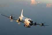
NOAA uses the Lockheed WP-3D OrionWP-3D Orion
|-See also:- External links:* *...
and Gulfstream IV-SP for most of its weather-related missions; however NOAA also uses light aircraft for some of its research. In conjunction with Jim Henson Productions, NOAA has two P-3s nicknamed 'Kermit' (NOAA42) and 'Miss Piggy' (NOAA43). The G-IV (NOAA49) is nicknamed 'Gonzo'. The Air Force Reserve Command
Air Force Reserve Command
The Air Force Reserve Command is a major command of the U.S. Air Force with its headquarters at Robins AFB, Georgia.It stood up as a major command of the Air Force on 17 February 1997....
's 53d Weather Reconnaissance Squadron Hurricane Hunters
Hurricane Hunters
The Hurricane Hunters are aircraft that fly into tropical cyclones in the North Atlantic Ocean and Northeastern Pacific Ocean for the specific purpose of directly measuring weather data in and around those storms. In the United States, the Air Force, Navy, and NOAA units have all participated in...
use the Lockheed WC-130J for their hurricane missions. The 53rd WRS Hurricane Hunters are located at Keesler Air Force Base
Keesler Air Force Base
Keesler Air Force Base is a United States Air Force base located in Biloxi, a city in Harrison County, Mississippi, United States. The base is named in honor of aviator 2d Lt Samuel Reeves Keesler, Jr., a Mississippi native killed in France in First World War.-Units:The base is home of...
in Biloxi, Mississippi
Biloxi, Mississippi
Biloxi is a city in Harrison County, Mississippi, in the United States. The 2010 census recorded the population as 44,054. Along with Gulfport, Biloxi is a county seat of Harrison County....
.
P-3
A normal hurricane reconnaissance or research mission can last from 9–10 hours, while a surveillance mission will typically last 8 hours. Most often, the scientists and crew aboard the aircraft deploy dropsonde
Dropsonde
A dropsonde is a weather reconnaissance device created by the National Center for Atmospheric Research , designed to be dropped from an aircraft at altitude to more accurately measure tropical storm conditions as the device falls to the surface...
s with GPS
Global Positioning System
The Global Positioning System is a space-based global navigation satellite system that provides location and time information in all weather, anywhere on or near the Earth, where there is an unobstructed line of sight to four or more GPS satellites...
which collect and transmit data as it descends toward the ocean. Once this data is received and QC'd by the crew, it is sent to the NOAA National Hurricane Center
National Hurricane Center
The National Hurricane Center , located at Florida International University in Miami, Florida, is the division of the National Weather Service responsible for tracking and predicting weather systems within the tropics between the Prime Meridian and the 140th meridian west poleward to the 30th...
for analysis. Other data is collected and transmitted by request. Personnel on board include pilots, navigators, engineers, technicians, and flight meteorologists (Flight Director
Flight director
The term flight director can refer to any one of the following:* the flight controller of a space flight* the flight director of an aviation navigation system...
s).
Projects in the past have included a low level jet experiment over South America, a bow echo
Bow echo
A bow echo is a term describing the characteristic radar return from a mesoscale convective system that is shaped like an archer’s bow. These systems can produce severe straight-line winds and occasionally tornadoes, causing major damage.-Research:...
and mesoscale convective study
Mesoscale Convective System
A mesoscale convective system is a complex of thunderstorms that becomes organized on a scale larger than the individual thunderstorms but smaller than extratropical cyclones, and normally persists for several hours or more...
in the Midwest, and ocean wind satellite verification missions over the Northern Atlantic and Pacific.
G-IV
The G-IV is a high altitude jet that can fly up to 45,000 feet. The G-IV has a similar crew to the P-3 with pilots, engineers, technicians, and a flight meteorologist (Flight DirectorFlight director
The term flight director can refer to any one of the following:* the flight controller of a space flight* the flight director of an aviation navigation system...
)
The G-IV flies around the periphery of both tropical and winter storms, including hurricanes, and drops sondes in order to gather data about the surrounding environment. This information is used to help predict the path of hurricanes. The dropsonde message is collected and QC'd by an on-board Flight Director, who then transmits the message to the National Centers for Environmental Prediction
National Centers for Environmental Prediction
The United States National Centers for Environmental Prediction delivers national and global weather, water, climate and space weather guidance, forecasts, warnings and analyses to its Partners and External User Communities...
(NCEP) and the National Hurricane Center
National Hurricane Center
The National Hurricane Center , located at Florida International University in Miami, Florida, is the division of the National Weather Service responsible for tracking and predicting weather systems within the tropics between the Prime Meridian and the 140th meridian west poleward to the 30th...
(NHC) for analysis.
The G-IV serves the NCEP Winter Storm Reconnaissance program every year in order to better predict the location and intensity of winter storms that head for the United States. The program was started by NCEP (National Center for Environmental Prediction). During the winter storm reconnaissance, air chemistry measurements are also taken from the upper troposphere
Troposphere
The troposphere is the lowest portion of Earth's atmosphere. It contains approximately 80% of the atmosphere's mass and 99% of its water vapor and aerosols....
. These flights are typically flown from Honolulu, Anchorage, or Yokota AB, Japan
Japan
Japan is an island nation in East Asia. Located in the Pacific Ocean, it lies to the east of the Sea of Japan, China, North Korea, South Korea and Russia, stretching from the Sea of Okhotsk in the north to the East China Sea and Taiwan in the south...
.