
Weather forecasting
Encyclopedia
Earth's atmosphere
The atmosphere of Earth is a layer of gases surrounding the planet Earth that is retained by Earth's gravity. The atmosphere protects life on Earth by absorbing ultraviolet solar radiation, warming the surface through heat retention , and reducing temperature extremes between day and night...
for a given location. Human beings have attempted to predict the weather informally for millennia, and formally since the nineteenth century. Weather forecasts are made by collecting quantitative data
Data
The term data refers to qualitative or quantitative attributes of a variable or set of variables. Data are typically the results of measurements and can be the basis of graphs, images, or observations of a set of variables. Data are often viewed as the lowest level of abstraction from which...
about the current state of the atmosphere and using scientific understanding of atmospheric processes
Meteorology
Meteorology is the interdisciplinary scientific study of the atmosphere. Studies in the field stretch back millennia, though significant progress in meteorology did not occur until the 18th century. The 19th century saw breakthroughs occur after observing networks developed across several countries...
to project how the atmosphere will evolve.
Once an all-human endeavor based mainly upon changes in barometric pressure
Atmospheric pressure
Atmospheric pressure is the force per unit area exerted into a surface by the weight of air above that surface in the atmosphere of Earth . In most circumstances atmospheric pressure is closely approximated by the hydrostatic pressure caused by the weight of air above the measurement point...
, current weather conditions, and sky condition, weather forecasting now relies on computer-based models
Numerical weather prediction
Numerical weather prediction uses mathematical models of the atmosphere and oceans to predict the weather based on current weather conditions. Though first attempted in the 1920s, it was not until the advent of computer simulation in the 1950s that numerical weather predictions produced realistic...
that take many atmospheric factors into account. Human input is still required to pick the best possible forecast model to base the forecast upon, which involves pattern recognition skills, teleconnection
Teleconnection
Teleconnection in atmospheric science refers to climate anomalies being related to each other at large distances...
s, knowledge of model performance, and knowledge of model biases. The chaotic
Chaos theory
Chaos theory is a field of study in mathematics, with applications in several disciplines including physics, economics, biology, and philosophy. Chaos theory studies the behavior of dynamical systems that are highly sensitive to initial conditions, an effect which is popularly referred to as the...
nature of the atmosphere, the massive computational power required to solve the equations that describe the atmosphere, error involved in measuring the initial conditions, and an incomplete understanding of atmospheric processes mean that forecasts become less accurate as the difference in current time and the time for which the forecast is being made (the range of the forecast) increases. The use of ensembles and model consensus help narrow the error and pick the most likely outcome.
There are a variety of end uses to weather forecasts. Weather warnings are important forecasts because they are used to protect life and property. Forecasts based on temperature
Temperature
Temperature is a physical property of matter that quantitatively expresses the common notions of hot and cold. Objects of low temperature are cold, while various degrees of higher temperatures are referred to as warm or hot...
and precipitation
Precipitation (meteorology)
In meteorology, precipitation In meteorology, precipitation In meteorology, precipitation (also known as one of the classes of hydrometeors, which are atmospheric water phenomena is any product of the condensation of atmospheric water vapor that falls under gravity. The main forms of precipitation...
are important to agriculture
Agriculture
Agriculture is the cultivation of animals, plants, fungi and other life forms for food, fiber, and other products used to sustain life. Agriculture was the key implement in the rise of sedentary human civilization, whereby farming of domesticated species created food surpluses that nurtured the...
, and therefore to traders within commodity markets. Temperature forecasts are used by utility companies to estimate demand over coming days. On an everyday basis, people use weather forecasts to determine what to wear on a given day. Since outdoor activities are severely curtailed by heavy rain, snow and the wind chill
Wind chill
Wind chill is the felt air temperature on exposed skin due to wind. The wind chill temperature is always lower than the air temperature, and the windchill is undefined at the higher temps...
, forecasts can be used to plan activities around these events, and to plan ahead and survive them.
History
For millennia people have tried to forecast the weather. In 650 BC, the BabyloniaBabylonia
Babylonia was an ancient cultural region in central-southern Mesopotamia , with Babylon as its capital. Babylonia emerged as a major power when Hammurabi Babylonia was an ancient cultural region in central-southern Mesopotamia (present-day Iraq), with Babylon as its capital. Babylonia emerged as...
ns predicted the weather from cloud patterns as well as astrology
Astrology
Astrology consists of a number of belief systems which hold that there is a relationship between astronomical phenomena and events in the human world...
. In about 340 BC, Aristotle
Aristotle
Aristotle was a Greek philosopher and polymath, a student of Plato and teacher of Alexander the Great. His writings cover many subjects, including physics, metaphysics, poetry, theater, music, logic, rhetoric, linguistics, politics, government, ethics, biology, and zoology...
described weather patterns in Meteorologica
Meteorology (Aristotle)
Meteorology is a treatise by Aristotle which contains his theories about the earth sciences. These include early accounts of water evaporation, weather phenomena, and earthquakes....
. Later, Theophrastus
Theophrastus
Theophrastus , a Greek native of Eresos in Lesbos, was the successor to Aristotle in the Peripatetic school. He came to Athens at a young age, and initially studied in Plato's school. After Plato's death he attached himself to Aristotle. Aristotle bequeathed to Theophrastus his writings, and...
compiled a book on weather forecasting, called the Book of Signs. Chinese
China
Chinese civilization may refer to:* China for more general discussion of the country.* Chinese culture* Greater China, the transnational community of ethnic Chinese.* History of China* Sinosphere, the area historically affected by Chinese culture...
weather prediction lore extends at least as far back as 300 BC, which was also around the same time ancient Indian astronomers developed weather-prediction methods. In 904 AD, Ibn Wahshiyya
Ibn Wahshiyya
Ibn Wahshiyya was an Iraqi alchemist, agriculturalist, farm toxicologist, egyptologist and historian born at Qusayn near Kufa in Iraq.Ibn Wahshiyya was one of the first historians to be able to at least partly decipher what was written in the ancient Egyptian hieroglyphs, by relating them to the...
's Nabatean Agriculture discussed the weather forecasting of atmospheric changes and signs from the planetary astral alterations; signs of rain based on observation of the lunar phase
Lunar phase
A lunar phase or phase of the moon is the appearance of the illuminated portion of the Moon as seen by an observer, usually on Earth. The lunar phases change cyclically as the Moon orbits the Earth, according to the changing relative positions of the Earth, Moon, and Sun...
s; and weather forecasts based on the movement of winds.
Ancient weather forecasting methods usually relied on observed patterns of events, also termed pattern recognition. For example, it might be observed that if the sunset was particularly red, the following day often brought fair weather. This experience accumulated over the generations to produce weather lore
Weather lore
Weather lore is the body of informal folklore related to the prediction of the weather.It has been a human desire for millennia to make accurate weather predictions. Oral and written history is full of rhymes, anecdotes, and adages meant to guide the uncertain in determining whether the next day...
. However, not all of these predictions prove reliable, and many of them have since been found not to stand up to rigorous statistical testing.
It was not until the invention of the electric telegraph
Electrical telegraph
An electrical telegraph is a telegraph that uses electrical signals, usually conveyed via telecommunication lines or radio. The electromagnetic telegraph is a device for human-to-human transmission of coded text messages....
in 1835 that the modern age of weather forecasting began. Before this time, it was not widely practicable to transport information about the current state of the weather any faster than a steam train (and the train also was a very new technology at that time). By the late 1840s, the telegraph allowed reports of weather conditions from a wide area to be received almost instantaneously, allowing forecasts to be made from knowledge of weather conditions further upwind
Windward and leeward
Windward is the direction upwind from the point of reference. Leeward is the direction downwind from the point of reference. The side of a ship that is towards the leeward is its lee side. If the vessel is heeling under the pressure of the wind, this will be the "lower side"...
. The two men most credited with the birth of forecasting as a science were Francis Beaufort
Francis Beaufort
Rear-Admiral Sir Francis Beaufort, FRS, FRGS was an Irish hydrographer and officer in Britain's Royal Navy...
(remembered chiefly for the Beaufort scale
Beaufort scale
The Beaufort Scale is an empirical measure that relates wind speed to observed conditions at sea or on land. Its full name is the Beaufort Wind Force Scale.-History:...
) and his protégé Robert Fitzroy
Robert FitzRoy
Vice-Admiral Robert FitzRoy RN achieved lasting fame as the captain of HMS Beagle during Charles Darwin's famous voyage, and as a pioneering meteorologist who made accurate weather forecasting a reality...
(developer of the Fitzroy barometer
Barometer
A barometer is a scientific instrument used in meteorology to measure atmospheric pressure. Pressure tendency can forecast short term changes in the weather...
). Both were influential men in British
United Kingdom of Great Britain and Ireland
The United Kingdom of Great Britain and Ireland was the formal name of the United Kingdom during the period when what is now the Republic of Ireland formed a part of it....
naval and governmental circles, and though ridiculed in the press at the time, their work gained scientific credence, was accepted by the Royal Navy
Royal Navy
The Royal Navy is the naval warfare service branch of the British Armed Forces. Founded in the 16th century, it is the oldest service branch and is known as the Senior Service...
, and formed the basis for all of today's weather forecasting knowledge. To convey information accurately, it became necessary to have a standard vocabulary describing clouds; this was achieved by means of a series of classifications and, in the 1890s, by pictorial cloud atlas
Cloud atlas
A cloud atlas is a pictorial key to the nomenclature of clouds. Early cloud atlases were an important element in the training of meteorologists and in weather forecasting, and the author of a 1923 atlas stated that "increasing use of the air as a means of transportation will require and lead to a...
es.
Great progress was made in the science of meteorology during the 20th century. The possibility of numerical weather prediction was proposed by Lewis Fry Richardson
Lewis Fry Richardson
Lewis Fry Richardson, FRS was an English mathematician, physicist, meteorologist, psychologist and pacifist who pioneered modern mathematical techniques of weather forecasting, and the application of similar techniques to studying the causes of wars and how to prevent them...
in 1922, though computers did not exist to complete the vast number of calculations required to produce a forecast before the event had occurred. The first computerised weather forecast was performed by a team led by the mathematician John von Neumann
John von Neumann
John von Neumann was a Hungarian-American mathematician and polymath who made major contributions to a vast number of fields, including set theory, functional analysis, quantum mechanics, ergodic theory, geometry, fluid dynamics, economics and game theory, computer science, numerical analysis,...
; von Neumann publishing the paper Numerical Integration of the Barotropic Vorticity Equation in 1950. Practical use of numerical weather prediction began in 1955, spurred by the development of programmable electronic computer
Computer
A computer is a programmable machine designed to sequentially and automatically carry out a sequence of arithmetic or logical operations. The particular sequence of operations can be changed readily, allowing the computer to solve more than one kind of problem...
s.
In the United States, the first public radio forecasts were made in 1925 by Edward B. "E.B." Rideout, on WEEI
WEEI
WEEI is a sports radio station in Boston, Massachusetts, that broadcasts on 850 kHz from a transmitter in Needham, Massachusetts, and is owned by Entercom Communications. The station is one of the top-rated sports talk radio stations in the nation. Studios are located in Brighton, Massachusetts...
, the Edison Electric Illuminating station in Boston. Rideout came from the U.S. Weather Bureau
National Weather Service
The National Weather Service , once known as the Weather Bureau, is one of the six scientific agencies that make up the National Oceanic and Atmospheric Administration of the United States government...
, as did WBZ
WBZ
WBZ may refer to:* WBZ , the United States' first commercial radio station originally broadcast from Springfield, Massachusetts, now licensed to Boston, Massachusetts, United States...
weather forecaster G. Harold Noyes in 1931. Television forecasts followed with Jimmie Fidler in Cincinnati in 1940 or 1947 on the DuMont Television Network
DuMont Television Network
The DuMont Television Network, also known as the DuMont Network, DuMont, Du Mont, or Dumont was one of the world's pioneer commercial television networks, rivalling NBC for the distinction of being first overall. It began operation in the United States in 1946. It was owned by DuMont...
. The Weather Channel
The Weather Channel
The Weather Channel is a US cable and satellite television network since May 2, 1982, that broadcasts weather forecasts and weather-related news, along with entertainment programming related to weather 24 hours a day...
is a 24-hour cable network that began broadcasting in May 1982.
How models create forecasts
The basic idea of numerical weather prediction is to sample the state of the fluid at a given time and use the equations of fluid dynamics
Fluid dynamics
In physics, fluid dynamics is a sub-discipline of fluid mechanics that deals with fluid flow—the natural science of fluids in motion. It has several subdisciplines itself, including aerodynamics and hydrodynamics...
and thermodynamics
Thermodynamics
Thermodynamics is a physical science that studies the effects on material bodies, and on radiation in regions of space, of transfer of heat and of work done on or by the bodies or radiation...
to estimate the state of the fluid at some time in the future. The main inputs from country-based weather services are surface observations from automated weather station
Weather station
A weather station is a facility, either on land or sea, with instruments and equipment for observing atmospheric conditions to provide information for weather forecasts and to study the weather and climate. The measurements taken include temperature, barometric pressure, humidity, wind speed, wind...
s at ground level over land and from weather buoys at sea. The World Meteorological Organization
World Meteorological Organization
The World Meteorological Organization is an intergovernmental organization with a membership of 189 Member States and Territories. It originated from the International Meteorological Organization , which was founded in 1873...
acts to standardize the instrumentation, observing practices and timing of these observations worldwide. Stations either report hourly in METAR
METAR
METAR is a format for reporting weather information. A METAR weather report is predominantly used by pilots in fulfillment of a part of a pre-flight weather briefing, and by meteorologists, who use aggregated METAR information to assist in weather forecasting....
reports, or every six hours in SYNOP
SYNOP
SYNOP is a numerical code used for reporting weather observations made by manned and automated weather stations. SYNOP reports are typically sent every six hours on shortwave using RTTY...
reports. Sites launch radiosonde
Radiosonde
A radiosonde is a unit for use in weather balloons that measures various atmospheric parameters and transmits them to a fixed receiver. Radiosondes may operate at a radio frequency of 403 MHz or 1680 MHz and both types may be adjusted slightly higher or lower as required...
s, which rise through the depth of the troposphere
Troposphere
The troposphere is the lowest portion of Earth's atmosphere. It contains approximately 80% of the atmosphere's mass and 99% of its water vapor and aerosols....
and well into the stratosphere
Stratosphere
The stratosphere is the second major layer of Earth's atmosphere, just above the troposphere, and below the mesosphere. It is stratified in temperature, with warmer layers higher up and cooler layers farther down. This is in contrast to the troposphere near the Earth's surface, which is cooler...
. Data from weather satellite
Weather satellite
The weather satellite is a type of satellite that is primarily used to monitor the weather and climate of the Earth. Satellites can be either polar orbiting, seeing the same swath of the Earth every 12 hours, or geostationary, hovering over the same spot on Earth by orbiting over the equator while...
s are used in areas of where traditional data sources are not available. Compared with similar data from radiosondes, the satellite data has the advantage of global coverage, however at a lower accuracy and resolution. Meteorological radar
Weather radar
Weather radar, also called weather surveillance radar and Doppler weather radar, is a type of radar used to locate precipitation, calculate its motion, estimate its type . Modern weather radars are mostly pulse-Doppler radars, capable of detecting the motion of rain droplets in addition to the...
provide information on precipitation location and intensity, which can be used to estimate precipitation accumulations over time. Additionally, if a Pulse Doppler
Pulse-doppler radar
Pulse-Doppler is a 4D radar system capable of detecting both target 3D location as well as measuring radial velocity . It uses the Doppler effect to avoid overloading computers and operators as well as to reduce power consumption...
weather radar
Weather radar
Weather radar, also called weather surveillance radar and Doppler weather radar, is a type of radar used to locate precipitation, calculate its motion, estimate its type . Modern weather radars are mostly pulse-Doppler radars, capable of detecting the motion of rain droplets in addition to the...
is used then wind speed and direction can be determined.
Commerce provides pilot reports along aircraft routes, and ship reports along shipping routes. Research flights using reconnaissance aircraft
Weather reconnaissance
Weather reconnaissance is the acquisition of weather data used for research and planning. Typically the term reconnaissance refers to observing weather from the air, as opposed to the ground .- Aircraft :Balloon...
fly in and around weather systems of interest such as tropical cyclone
Tropical cyclone
A tropical cyclone is a storm system characterized by a large low-pressure center and numerous thunderstorms that produce strong winds and heavy rain. Tropical cyclones strengthen when water evaporated from the ocean is released as the saturated air rises, resulting in condensation of water vapor...
s. Reconnaissance aircraft are also flown over the open oceans during the cold season into systems which cause significant uncertainty in forecast guidance, or are expected to be of high impact 3–7 days into the future over the downstream continent.
Models are initialized using this observed data. The irregularly spaced observations are processed by data assimilation
Data assimilation
Applications of data assimilation arise in many fields of geosciences, perhaps most importantly in weather forecasting and hydrology. Data assimilation proceeds by analysis cycles...
and objective analysis methods, which perform quality control and obtain values at locations usable by the model's mathematical algorithms (usually an evenly spaced grid). The data are then used in the model as the starting point for a forecast. Commonly, the set of equations used to predict the known as the physics and dynamics of the atmosphere are called primitive equations
Primitive equations
The primitive equations are a set of nonlinear differential equations that are used to approximate global atmospheric flow and are used in most atmospheric models...
. These equations are initialized from the analysis data and rates of change are determined. The rates of change predict the state of the atmosphere a short time into the future. The equations are then applied to this new atmospheric state to find new rates of change, and these new rates of change predict the atmosphere at a yet further time into the future. This time stepping procedure is continually repeated until the solution reaches the desired forecast time. The length of the time step is related to the distance between the points on the computational grid. Time steps for global climate model
Global climate model
A General Circulation Model is a mathematical model of the general circulation of a planetary atmosphere or ocean and based on the Navier–Stokes equations on a rotating sphere with thermodynamic terms for various energy sources . These equations are the basis for complex computer programs commonly...
s may be on the order of tens of minutes, while time steps for regional models may be a few seconds to a few minutes.
Essentially, a model is a computer program that produces meteorological information for future times at given locations and altitudes. Within any modern model is a set of equations, known as the primitive equations
Primitive equations
The primitive equations are a set of nonlinear differential equations that are used to approximate global atmospheric flow and are used in most atmospheric models...
, used to predict the future state of the atmosphere. These equations—along with the ideal gas law
Ideal gas law
The ideal gas law is the equation of state of a hypothetical ideal gas. It is a good approximation to the behavior of many gases under many conditions, although it has several limitations. It was first stated by Émile Clapeyron in 1834 as a combination of Boyle's law and Charles's law...
—are used to evolve the density
Density
The mass density or density of a material is defined as its mass per unit volume. The symbol most often used for density is ρ . In some cases , density is also defined as its weight per unit volume; although, this quantity is more properly called specific weight...
, pressure
Pressure
Pressure is the force per unit area applied in a direction perpendicular to the surface of an object. Gauge pressure is the pressure relative to the local atmospheric or ambient pressure.- Definition :...
, and potential temperature scalar field
Scalar field
In mathematics and physics, a scalar field associates a scalar value to every point in a space. The scalar may either be a mathematical number, or a physical quantity. Scalar fields are required to be coordinate-independent, meaning that any two observers using the same units will agree on the...
s and the velocity
Velocity
In physics, velocity is speed in a given direction. Speed describes only how fast an object is moving, whereas velocity gives both the speed and direction of the object's motion. To have a constant velocity, an object must have a constant speed and motion in a constant direction. Constant ...
vector field
Vector field
In vector calculus, a vector field is an assignmentof a vector to each point in a subset of Euclidean space. A vector field in the plane for instance can be visualized as an arrow, with a given magnitude and direction, attached to each point in the plane...
of the atmosphere through time. Additional transport equations for pollutants and other aerosol
Aerosol
Technically, an aerosol is a suspension of fine solid particles or liquid droplets in a gas. Examples are clouds, and air pollution such as smog and smoke. In general conversation, aerosol usually refers to an aerosol spray can or the output of such a can...
s are included in some primitive-equation mesoscale models as well. The equations used are nonlinear partial differential equations which are impossible to solve exactly through analytical methods, with the exception of a few idealized cases. Therefore, numerical methods obtain approximate solutions. Different models use different solution methods: some global models use spectral method
Spectral method
Spectral methods are a class of techniques used in applied mathematics and scientific computing to numerically solve certain Dynamical Systems, often involving the use of the Fast Fourier Transform. Where applicable, spectral methods have excellent error properties, with the so called "exponential...
s for the horizontal dimensions and finite difference method
Finite difference method
In mathematics, finite-difference methods are numerical methods for approximating the solutions to differential equations using finite difference equations to approximate derivatives.- Derivation from Taylor's polynomial :...
s for the vertical dimension, while regional models and other global models usually use finite-difference methods in all three dimensions.
These equations are initialized from the analysis data and rates of change are determined. These rates of change predict the state of the atmosphere a short time into the future; the time increment for this prediction is called a time step. The equations are then applied to this new atmospheric state to find new rates of change, and these new rates of change predict the atmosphere at a yet further time step into the future. This time stepping is repeated until the solution reaches the desired forecast time. The length of the time step chosen within the model is related to the distance between the points on the computational grid, and is chosen to maintain numerical stability
Numerical stability
In the mathematical subfield of numerical analysis, numerical stability is a desirable property of numerical algorithms. The precise definition of stability depends on the context, but it is related to the accuracy of the algorithm....
. Time steps for global models are on the order of tens of minutes, while time steps for regional models are between one and four minutes. The global models are run at varying times into the future. The UKMET Unified Model
Unified Model
The Unified Model is a Numerical Weather Prediction and climate modeling software suite originally developed by the United Kingdom Met Office, and now both used and further developed by many weather-forecasting agencies around the world...
is run six days into the future, the European Centre for Medium-Range Weather Forecasts
European Centre for Medium-Range Weather Forecasts
The European Centre for Medium-Range Weather Forecasts is an independent intergovernmental organisation supported by 19 European Member States and 15 Co-operating States...
model is run out to 10 days into the future, while the Global Forecast System
Global Forecast System
The Global Forecast System is a global numerical weather prediction computer model run by NOAA. This mathematical model is run four times a day and produces forecasts up to 16 days in advance, but with decreasing spatial and temporal resolution over time...
model run by the Environmental Modeling Center
Environmental Modeling Center
The Environmental Modeling Center , improves numerical weather, marine and climate predictions at the National Centers for Environmental Prediction , through a broad program of research in data assimilation and modeling...
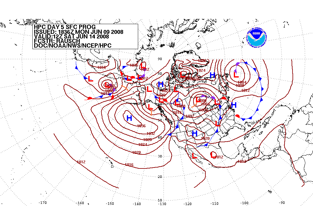
is run 16 days into the future. The visual output produced by a model solution is known as a prognostic chart
Prognostic chart
Prognostic charts are maps which display what the weather is expected to be like at a future time; in other words, a forecast map. Within the United States, manual prognostic charts generated by the National Centers for Environmental Prediction have special symbols which require interpretation...
, or prog. The raw output is often modified before being presented as the forecast. This can be in the form of statistical techniques to remove known bias
Bias
Bias is an inclination to present or hold a partial perspective at the expense of alternatives. Bias can come in many forms.-In judgement and decision making:...
es in the model, or of adjustment to take into account consensus among other numerical weather forecasts. MOS or model output statistics is a technique used to interpret numerical model output and produce site-specific guidance. This guidance is presented in coded numerical form, and can be obtained for nearly all National Weather Service reporting stations in the United States. As proposed by Edward Lorenz in 1963, long range forecasts, those made at a range of two weeks or more, are impossible to definitively predict the state of the atmosphere, owing to the chaotic nature
Chaos theory
Chaos theory is a field of study in mathematics, with applications in several disciplines including physics, economics, biology, and philosophy. Chaos theory studies the behavior of dynamical systems that are highly sensitive to initial conditions, an effect which is popularly referred to as the...
of the fluid dynamics
Fluid dynamics
In physics, fluid dynamics is a sub-discipline of fluid mechanics that deals with fluid flow—the natural science of fluids in motion. It has several subdisciplines itself, including aerodynamics and hydrodynamics...
equations involved. Extremely small errors in the initial input, such as temperatures and winds, within numerical models doubles every five days.
Persistence
The simplest method of forecasting the weather, persistence, relies upon today's conditions to forecast the conditions tomorrow. This can be a valid way of forecasting the weather when it is steady state, such as during the summer season in the tropics. This method of forecasting strongly depends upon the presence of a stagnant weather pattern. It can be useful in both short range forecasts and long range forecasts.Use of a barometer
Measurements of barometric pressure and the pressure tendency (the change of pressure over time) have been used in forecasting since the late 19th century. The larger the change in pressure, especially if more than 3.5 hPa (2.6 mmHg), the larger the change in weather can be expected. If the pressure drop is rapid, a low pressure systemLow pressure area
A low-pressure area, or "low", is a region where the atmospheric pressure at sea level is below that of surrounding locations. Low-pressure systems form under areas of wind divergence which occur in upper levels of the troposphere. The formation process of a low-pressure area is known as...
is approaching, and there is a greater chance of rain. Rapid pressure rises
High pressure area
A high-pressure area is a region where the atmospheric pressure at the surface of the planet is greater than its surrounding environment. Winds within high-pressure areas flow outward due to the higher density air near their center and friction with land...
are associated with improving weather conditions, such as clearing skies.
Looking at the sky

Cirrostratus cloud
Cirrostratus clouds are thin, generally uniform clouds, composed of ice-crystals. They are difficult to detect and if capable of forming halos the cloud takes the form of thin cirrostratus nebulosus. The cloud has a fibrous texture with no haloes if it is thicker cirrostratus fibratus. On the...
s can lead to halo
Halo
Halo may refer to:* Halo , a glow or ring of light around a head or person in art-Game franchise and spin-offs:*Halo , a video game franchise by Bungie and Microsoft Game Studios...
s around the moon
Moon
The Moon is Earth's only known natural satellite,There are a number of near-Earth asteroids including 3753 Cruithne that are co-orbital with Earth: their orbits bring them close to Earth for periods of time but then alter in the long term . These are quasi-satellites and not true moons. For more...
, which indicates an approach of a warm front
Warm front
A warm front is a density discontinuity located at the leading edge of a homogeneous warm air mass, and is typically located on the equator-facing edge of an isotherm gradient...
and its associated rain
Rain
Rain is liquid precipitation, as opposed to non-liquid kinds of precipitation such as snow, hail and sleet. Rain requires the presence of a thick layer of the atmosphere to have temperatures above the melting point of water near and above the Earth's surface...
. Morning fog
Fog
Fog is a collection of water droplets or ice crystals suspended in the air at or near the Earth's surface. While fog is a type of stratus cloud, the term "fog" is typically distinguished from the more generic term "cloud" in that fog is low-lying, and the moisture in the fog is often generated...
portends fair conditions, as rainy conditions are preceded by wind or clouds which prevent fog formation. The approach of a line of thunderstorm
Thunderstorm
A thunderstorm, also known as an electrical storm, a lightning storm, thundershower or simply a storm is a form of weather characterized by the presence of lightning and its acoustic effect on the Earth's atmosphere known as thunder. The meteorologically assigned cloud type associated with the...
s could indicate the approach of a cold front
Cold front
A cold front is defined as the leading edge of a cooler mass of air, replacing a warmer mass of air.-Development of cold front:The cooler and denser air wedges under the less-dense warmer air, lifting it...
. Cloud-free skies are indicative of fair weather for the near future. A bar
Bar (tropical cyclone)
The bar of a mature tropical cyclone is a very dark gray-black layer of cloud appearing near the horizon as seen from an observer preceding the approach of the storm, and is composed of dense stratocumulus clouds. Cumulus and cumulonimbus clouds bearing precipitation follow immediately after the...
can indicate a coming tropical cyclone. The use of sky cover in weather prediction has led to various weather lore
Weather lore
Weather lore is the body of informal folklore related to the prediction of the weather.It has been a human desire for millennia to make accurate weather predictions. Oral and written history is full of rhymes, anecdotes, and adages meant to guide the uncertain in determining whether the next day...
over the centuries.
Nowcasting
The term nowcasting is also used in economicsNowcasting (economics)
The term ‘nowcasting’ is a contraction of ‘now’ and ‘forecasting’. The term is used in both economics and meteorology. This article is about its use in economics; see meteorology for its use referring to techniques used to make short-term weather forecasts, typically in the 0 to 12 hour...
.
The forecasting of the weather within the next six hours is often referred to as nowcasting. In this time range it is possible to forecast smaller features such as individual showers and thunderstorms with reasonable accuracy, as well as other features too small to be resolved by a computer model. A human given the latest radar, satellite and observational data will be able to make a better analysis of the small scale features present and so will be able to make a more accurate forecast for the following few hours.
Use of forecast models
Analog technique
The Analog technique is a complex way of making a forecast, requiring the forecaster to remember a previous weather event which is expected to be mimicked by an upcoming event. What makes it a difficult technique to use is that there is rarely a perfect analog for an event in the future. Some call this type of forecasting pattern recognition. It remains a useful method of observing rainfall over data voids such as oceans, as well as the forecasting of precipitation amounts and distribution in the future. A similar technique is used in medium range forecasting, which is known as teleconnections, when systems in other locations are used to help pin down the location of another system within the surrounding regime. An example of teleconnections are by using El Niño-Southern OscillationEl Niño-Southern Oscillation
El Niño/La Niña-Southern Oscillation, or ENSO, is a quasiperiodic climate pattern that occurs across the tropical Pacific Ocean roughly every five years...
(ENSO) related phenomena.
- Analog model – A model based on similarities between the system under study and another system or process.
- Analytical model – A model that uses classic methods such as calculus or algebra to solve a series of equations.
- Conceptual model – A simplified representation of the system being examined.
- Continuous model – A model that uses continuous simulation, as opposed to a single-event model.
- Deterministic model – A model that produces the same output for a given input without consideration for risk or uncertainty.
- Empirical model – A model represented by simplified processes based on observation, measurements, or practical experience rather than solely on principles or theory. A lumped model is an example.
- Explicit model – A numerical model that uses parameter values or unknown variables at the beginning of a time step in the computational algorithms.
- Implicit model – A numerical model that uses parameter values or unknown variables at the end of a time step in the computational algorithms.
- Mass balance model – A model based on the conservation of mass and focuses on balancing inputs and outputs from the model area. Also known as a zero-dimensional model.
- Numerical model – A model that uses a numerical method to solve a series of equations, as opposed to an analytical model. The results from numerical models are often approximations, while analytic models produce exact solutions.
- One-dimensional model – A model that includes only one space dimension.
- Pseudo-deterministic model – A semi-distributed model.
- Stochastic mathematical model – A model that includes statistical elements and produces a set of outputs for a given set of inputs. The output represents a set of expected values.
- Two-dimensional model – A model that includes two space dimensions, usually horizontal and vertical averaging.
Most end users of forecasts are members of the general public. Thunderstorms can create strong winds and dangerous lightning
Lightning
Lightning is an atmospheric electrostatic discharge accompanied by thunder, which typically occurs during thunderstorms, and sometimes during volcanic eruptions or dust storms...
strikes that can lead to deaths, power outages, and widespread hail damage. Heavy snow or rain can bring transportation and commerce to a stand-still, as well as cause flooding in low-lying areas. Excessive heat
Heat wave
A heat wave is a prolonged period of excessively hot weather, which may be accompanied by high humidity. There is no universal definition of a heat wave; the term is relative to the usual weather in the area...
or cold wave
Cold wave
A cold wave is a weather phenomenon that is distinguished by a cooling of the air. Specifically, as used by the U.S. National Weather Service, a cold wave is a rapid fall in temperature within a 24 hour period requiring substantially increased protection to agriculture, industry, commerce, and...
s can sicken or kill those with inadequate utilities, and drought
Drought
A drought is an extended period of months or years when a region notes a deficiency in its water supply. Generally, this occurs when a region receives consistently below average precipitation. It can have a substantial impact on the ecosystem and agriculture of the affected region...
s can impact water usage and destroy vegetation.
Several countries employ government agencies to provide forecasts and watches/warnings/advisories to the public in order to protect life and property and maintain commercial interests. Knowledge of what the end user needs from a weather forecast must be taken into account to present the information in a useful and understandable way. Examples include the National Oceanic and Atmospheric Administration
National Oceanic and Atmospheric Administration
The National Oceanic and Atmospheric Administration , pronounced , like "noah", is a scientific agency within the United States Department of Commerce focused on the conditions of the oceans and the atmosphere...
's National Weather Service
National Weather Service
The National Weather Service , once known as the Weather Bureau, is one of the six scientific agencies that make up the National Oceanic and Atmospheric Administration of the United States government...
(NWS) and Environment Canada
Environment Canada
Environment Canada , legally incorporated as the Department of the Environment under the Department of the Environment Act Environment Canada (EC) (French: Environnement Canada), legally incorporated as the Department of the Environment under the Department of the Environment Act Environment...
's Meteorological Service
Meteorological Service of Canada
The Meteorological Service of Canada , also known as "The Canadian Weather Service", is a division of Environment Canada, which primarily provides public meteorological information and weather forecasts and warnings of severe weather and other environmental hazards...
(MSC). Traditionally, newspaper, television, and radio have been the primary outlets for presenting weather forecast information to the public. Increasingly, the internet is being used due to the vast amount of specific information that can be found. In all cases, these outlets update their forecasts on a regular basis.
Severe weather alerts and advisories
A major part of modern weather forecasting is the severe weather alerts and advisories which the national weather services issue in the case that severe or hazardous weather is expected. This is done to protect life and property. Some of the most commonly known of severe weather advisories are the severe thunderstormSevere thunderstorm warning
A severe thunderstorm warning is issued when trained storm spotters or a Doppler weather radar indicate a strong thunderstorm is producing dangerously large hail or high winds, capable of causing significant damage. In the United States, it does not account for lightning or flooding...
and tornado warning
Tornado warning
A tornado warning is an alert issued by government weather services to warn that severe thunderstorms with tornadoes may be imminent. It can be issued after a tornado or funnel cloud has been spotted by eye, or more commonly if there are radar indications of tornado formation...
, as well as the severe thunderstorm
Severe thunderstorm watch
[File:Annual_severe_thunderstorm_watch_frequency_in_the_United_States.svg|thumb|right|300px|Map of average annual severe thunderstorm watches in the United States between 1999 and 2008.Legend:...
and tornado watch
Tornado watch
A tornado watch is issued when conditions are right for a tornado to form. Since any thunderstorm capable of producing a tornado is defined as severe, a tornado watch is also automatically a severe thunderstorm watch...
. Other forms of these advisories include winter weather, high wind, flood
Flood warning
Flood warning is closely linked to the task of flood forecasting. The distinction between the two is that the outcome of flood forecasting is a set of forecast time-profiles of channel flows or river levels at various locations, while "flood warning" is the task of making use of these forecasts to...
, tropical cyclone
Tropical cyclone
A tropical cyclone is a storm system characterized by a large low-pressure center and numerous thunderstorms that produce strong winds and heavy rain. Tropical cyclones strengthen when water evaporated from the ocean is released as the saturated air rises, resulting in condensation of water vapor...
, and fog. Severe weather advisories and alerts are broadcast through the media, including radio, using emergency systems as the Emergency Alert System
Emergency Alert System
The Emergency Alert System is a national warning system in the United States put into place on January 1, 1997, when it superseded the Emergency Broadcast System , which itself had superseded the CONELRAD System...
which break into regular programming.
Air traffic
Because the aviation industry is especially sensitive to the weather, accurate weather forecasting is essential. Fog or exceptionally low ceilings
Ceiling (cloud)
- ICAO :The height above the ground or water of the base of the lowest layer of cloud below 6000 meters covering more than halfthe sky.- United Kingdom :...
can prevent many aircraft from landing and taking off. Turbulence
Turbulence
In fluid dynamics, turbulence or turbulent flow is a flow regime characterized by chaotic and stochastic property changes. This includes low momentum diffusion, high momentum convection, and rapid variation of pressure and velocity in space and time...
and icing
Atmospheric icing
Atmospheric icing occurs when water droplets in the atmosphere freeze on objects they contact. This can be extremely dangerous to aircraft, as the built-up ice changes the aerodynamics of the flight surfaces, which can increase the risk of a subsequent stalling of the airfoil...
are also significant in-flight hazards. Thunderstorms are a problem for all aircraft because of severe turbulence due to their updrafts
Vertical draft
An updraft or downdraft is the vertical movement of air as a weather related phenomenon. One of two forces causes the air to move. Localized regions of warm or cool air will exhibit vertical movement. A mass of warm air will typically be less dense than the surrounding region, and so will rise...
and outflow boundaries
Outflow boundary
An outflow boundary, also known as a gust front, is a storm-scale or mesoscale boundary separating thunderstorm-cooled air from the surrounding air; similar in effect to a cold front, with passage marked by a wind shift and usually a drop in temperature and a related pressure jump...
, icing due to the heavy precipitation, as well as large hail
Hail
Hail is a form of solid precipitation. It consists of balls or irregular lumps of ice, each of which is referred to as a hail stone. Hail stones on Earth consist mostly of water ice and measure between and in diameter, with the larger stones coming from severe thunderstorms...
, strong winds, and lightning, all of which can cause severe damage to an aircraft in flight. Volcanic ash
Volcanic ash
Volcanic ash consists of small tephra, which are bits of pulverized rock and glass created by volcanic eruptions, less than in diameter. There are three mechanisms of volcanic ash formation: gas release under decompression causing magmatic eruptions; thermal contraction from chilling on contact...
is also a significant problem for aviation, as aircraft can lose engine power within ash clouds. On a day to day basis airliners are routed to take advantage of the jet stream
Jet stream
Jet streams are fast flowing, narrow air currents found in the atmospheres of some planets, including Earth. The main jet streams are located near the tropopause, the transition between the troposphere and the stratosphere . The major jet streams on Earth are westerly winds...
tailwind to improve fuel efficiency. Aircrews are briefed prior to takeoff
Takeoff
Takeoff is the phase of flight in which an aerospace vehicle goes from the ground to flying in the air.For horizontal takeoff aircraft this usually involves starting with a transition from moving along the ground on a runway. For balloons, helicopters and some specialized fixed-wing aircraft , no...
on the conditions to expect en route and at their destination. Additionally, airports often change which runway
Runway
According to ICAO a runway is a "defined rectangular area on a land aerodrome prepared for the landing and take-off of aircraft." Runways may be a man-made surface or a natural surface .- Orientation and dimensions :Runways are named by a number between 01 and 36, which is generally one tenth...
is being used to take advantage of a headwind. This reduces the distance required for takeoff, and eliminates potential crosswind
Crosswind
A crosswind is any wind that has a perpendicular component to the line or direction of travel. In aviation, a crosswind is the component of wind that is blowing across the runway making landings and take-offs more difficult than if the wind were blowing straight down the runway...
s.
Marine
Commercial and recreational use of waterways can be limited significantly by wind direction and speed, waveOcean surface wave
In fluid dynamics, wind waves or, more precisely, wind-generated waves are surface waves that occur on the free surface of oceans, seas, lakes, rivers, and canals or even on small puddles and ponds. They usually result from the wind blowing over a vast enough stretch of fluid surface. Waves in the...
periodicity and heights, tides, and precipitation. These factors can each influence the safety of marine transit. Consequently, a variety of codes have been established to efficiently transmit detailed marine weather forecasts to vessel pilots via radio, for example the MAFOR
MAFOR
MAFOR, an abbreviation of MArine FORecast, is a North American code used in the transmission of marine weather forecasts to compress a volume of meteorological and marine information into shorter code for convenience during radio broadcasting...
(marine forecast). Typical weather forecasts can be received at sea through the use of RTTY, Navtex
Navtex
NAVTEX is an international automated medium frequency direct-printing service for delivery of navigational and meteorological warnings and forecasts, as well as urgent marine safety information to ships...
and Radiofax
Radiofax
Radiofax, also known as weatherfax and HF fax , is an analogue mode for transmitting monochrome images. It was the predecessor to slow-scan television...
.
Agriculture
FarmerFarmer
A farmer is a person engaged in agriculture, who raises living organisms for food or raw materials, generally including livestock husbandry and growing crops, such as produce and grain...
s rely on weather forecasts to decide what work to do on any particular day. For example, drying hay
Hay
Hay is grass, legumes or other herbaceous plants that have been cut, dried, and stored for use as animal fodder, particularly for grazing livestock such as cattle, horses, goats, and sheep. Hay is also fed to pets such as rabbits and guinea pigs...
is only feasible in dry weather. Prolonged periods of dryness can ruin cotton
Cotton
Cotton is a soft, fluffy staple fiber that grows in a boll, or protective capsule, around the seeds of cotton plants of the genus Gossypium. The fiber is almost pure cellulose. The botanical purpose of cotton fiber is to aid in seed dispersal....
, wheat
Wheat
Wheat is a cereal grain, originally from the Levant region of the Near East, but now cultivated worldwide. In 2007 world production of wheat was 607 million tons, making it the third most-produced cereal after maize and rice...
, and corn
Maize
Maize known in many English-speaking countries as corn or mielie/mealie, is a grain domesticated by indigenous peoples in Mesoamerica in prehistoric times. The leafy stalk produces ears which contain seeds called kernels. Though technically a grain, maize kernels are used in cooking as a vegetable...
crops. While corn crops can be ruined by drought, their dried remains can be used as a cattle feed substitute in the form of silage
Silage
Silage is fermented, high-moisture fodder that can be fed to ruminants or used as a biofuel feedstock for anaerobic digesters. It is fermented and stored in a process called ensiling or silaging, and is usually made from grass crops, including corn , sorghum or other cereals, using the entire...
. Frost
Frost
Frost is the solid deposition of water vapor from saturated air. It is formed when solid surfaces are cooled to below the dew point of the adjacent air as well as below the freezing point of water. Frost crystals' size differ depending on time and water vapour available. Frost is also usually...
s and freezes play havoc with crops both during the spring and fall. For example, peach
Peach
The peach tree is a deciduous tree growing to tall and 6 in. in diameter, belonging to the subfamily Prunoideae of the family Rosaceae. It bears an edible juicy fruit called a peach...
trees in full bloom can have their potential peach crop decimated by a spring freeze. Orange
Orange (fruit)
An orange—specifically, the sweet orange—is the citrus Citrus × sinensis and its fruit. It is the most commonly grown tree fruit in the world....
groves can suffer significant damage during frosts and freezes, regardless of their timing.
Forestry
Weather forecasting of wind, precipitations and humidity is essential for preventing and controlling wildfireWildfire
A wildfire is any uncontrolled fire in combustible vegetation that occurs in the countryside or a wilderness area. Other names such as brush fire, bushfire, forest fire, desert fire, grass fire, hill fire, squirrel fire, vegetation fire, veldfire, and wilkjjofire may be used to describe the same...
s. Different indices, like the Forest fire weather index and the Haines Index
Haines Index
Haines Index is a weather index developed by meteorologist Donald Haines in 1988 that measures the potential for rapid forest fire growth. The index is derived from the stability and moisture content of the lower atmosphere. These data may be acquired with a radiosonde...
, have been developed to predict the areas more at risk to experience fire from natural or human causes. Conditions for the development of harmful insects can be predicted by forecasting the evolution of weather, too.
Utility companies
Electricity and gas companies rely on weather forecasts to anticipate demand which can be strongly affected by the weather. They use the quantity termed the degree day to determine how strong of a use there will be for heating (heating degree day
Heating degree day
Heating degree day is a measurement designed to reflect the demand for energy needed to heat a home or business. It is derived from measurements of outside air temperature. The heating requirements for a given structure at a specific location are considered to be directly proportional to the...
) or cooling (cooling degree day). These quantities are based on a daily average temperature of 65 °F (18.3 °C). Cooler temperatures force heating degree days (one per degree Fahrenheit), while warmer temperatures force cooling degree days. In winter, severe cold weather can cause a surge in demand as people turn up their heating. Similarly, in summer a surge in demand can be linked with the increased use of air conditioning
Air conditioning
An air conditioner is a home appliance, system, or mechanism designed to dehumidify and extract heat from an area. The cooling is done using a simple refrigeration cycle...
systems in hot weather. By anticipating a surge in demand, utility companies can purchase additional supplies of power or natural gas before the price increases, or in some circumstances, supplies are restricted through the use of brownout
Power outage
A power outage is a short- or long-term loss of the electric power to an area.There are many causes of power failures in an electricity network...
s and blackouts.
Private sector
Increasingly, private companies pay for weather forecasts tailored to their needs so that they can increase their profits or avoid large losses. For example, supermarket chains may change the stocks on their shelves in anticipation of different consumer spending habits in different weather conditions. Weather forecasts can be used to invest in the commodity market, such as futures in oranges, corn, soybeans, and oil.US Navy

United States Navy
The United States Navy is the naval warfare service branch of the United States Armed Forces and one of the seven uniformed services of the United States. The U.S. Navy is the largest in the world; its battle fleet tonnage is greater than that of the next 13 largest navies combined. The U.S...
provides a special service to both themselves and the rest of the federal government by issuing forecasts for tropical cyclone across the Pacific and Indian Oceans through their Joint Typhoon Warning Center
Joint Typhoon Warning Center
The Joint Typhoon Warning Center is a joint United States Navy – United States Air Force task force located at the Naval Maritime Forecast Center in Pearl Harbor, Hawaii...
.
US Air Force
Within the United States, Air Force Weather provides weather forecasting for the Air Force and the Army. Air ForceUnited States Air Force
The United States Air Force is the aerial warfare service branch of the United States Armed Forces and one of the American uniformed services. Initially part of the United States Army, the USAF was formed as a separate branch of the military on September 18, 1947 under the National Security Act of...
forecasters cover air operations in both wartime and peacetime operations and provide Army
United States Army
The United States Army is the main branch of the United States Armed Forces responsible for land-based military operations. It is the largest and oldest established branch of the U.S. military, and is one of seven U.S. uniformed services...
support; United States Coast Guard
United States Coast Guard
The United States Coast Guard is a branch of the United States Armed Forces and one of the seven U.S. uniformed services. The Coast Guard is a maritime, military, multi-mission service unique among the military branches for having a maritime law enforcement mission and a federal regulatory agency...
marine science technicians provide ship forecasts for ice breakers and other various operations within their realm; and Marine forecasters provide support for ground- and air-based United States Marine Corps
United States Marine Corps
The United States Marine Corps is a branch of the United States Armed Forces responsible for providing power projection from the sea, using the mobility of the United States Navy to deliver combined-arms task forces rapidly. It is one of seven uniformed services of the United States...
operations. All four military branches take their initial enlisted meteorology technical training at Keesler Air Force Base
Keesler Air Force Base
Keesler Air Force Base is a United States Air Force base located in Biloxi, a city in Harrison County, Mississippi, United States. The base is named in honor of aviator 2d Lt Samuel Reeves Keesler, Jr., a Mississippi native killed in France in First World War.-Units:The base is home of...
. Military and civilian forecasters actively cooperate in analyzing, creating and critiquing weather forecast products.
See also
|
National Collegiate Weather Forecasting Contest The National Collegiate Weather Forecasting Contest, or NCWFC, was a yearly competition among colleges and Universities in the US run by Penn State. There were over 1000 participants from about 45 institutions... National Weatherperson's Day National Weatherperson's Day, also known as National Weatherman's Day, is a holiday observed on February 5 primarily in the United States. It recognizes individuals in the fields of meteorology, weather forecasting and broadcast meteorology, as well as volunteer storm spotters and observers... Trend estimation Trend estimation is a statistical technique to aid interpretation of data. When a series of measurements of a process are treated as a time series, trend estimation can be used to make and justify statements about tendencies in the data... Tropical cyclone forecasting Tropical cyclone forecasting is the science and art of forecasting where a tropical cyclone's center, and its effects, are expected to be at some point in the future. There are several elements to tropical cyclone forecasting: track forecasting, intensity forecasting, rainfall forecasting, storm... Weather control Weather control is the act of manipulating or altering certain aspects of the environment to produce desirable changes in weather. Weather control can have the goal of preventing damaging weather, such as hurricanes or tornadoes, from occurring; of causing beneficial weather, such as rainfall in... Weather wars Weather wars, sometimes called TV radar wars or Doppler wars, are a kind of sensationalist journalism primarily concerning weather news... WxChallenge The WxChallenge is a weather forecasting competition between colleges in North America. The competition is run by the University of Oklahoma. In its first official semester, fall 2006, there were 1,262 participants from 53 institutions... Zambretti Forecaster The Zambretti Forecaster is an weather forecasting instrument used in conjunction with a barometer. It interprets the reading of a barometer into one forecast from a large selection of permutations after making allowances for variable factors. These include wind direction, a rising, falling or... |
Meteorological agencies
These are academic or governmental meteorology organizations. Most provide at least a limited forecast for their area of interest on their website.- The World Meteorological Organization
- European Centre for Medium Range Weather Forecasting (ECMWF)
- Australian Bureau of Meteorology
- Royal Meteorological Institute of Belgium
- Environment Canada Weather Office
- Finnish Meteorological Institute
- French National Meteorological Service
- Indian Meteorological Department(IMD)
- National Centre for Medium Range Weather Forecast (NCMRWF)
- Indian Institute of Tropical Meteorology (IITM)
- National Atmospheric Research Laboratory (NARL)
- Pakistan Meteorological Department
- The Hellenic National Meteorological Service (Greece)
- Hong Kong Observatory
- Met Éireann (Ireland)
- Italian Air Force (Aeronautica Militare) Meteorological Service
- Korea Meteorological Administration
- New Zealand MetService
- South African Weather Service
- Meteo Suisse (Swiss Weather Agency)
- The Met Office of the UK
- yr.no (a joint online weather service from the Norwegian Meteorological Institute (met.no) and the Norwegian Broadcasting Corporation (NRK))
- Unidad de Meteorología - IVIC (Meteorology Unit - Venezuela Institute of Scientific Research)
- Instituto Nacional de Hidrometeorología
Other external links
- Economic history and impact of weather forecasting from EH.net
- Dynamic Weather Forecaster Iowa State University's online educational tool for weather forecasting
- "World Weather News by Radio" Popular Mechanics, January 1930, pp.50-55, article on international weather report systems set up after World War One, using wireless broadcasting from various stations and ships world wide