
Mount Baker-Snoqualmie National Forest
Encyclopedia
The Mount Baker-Snoqualmie National Forest in Washington extends more than 140 miles (225.3 km) along the western slopes of the Cascade Range
from the Canadian border to the northern boundary of Mount Rainier National Park
. Forest headquarters are located in the city of Everett
.
, Whatcom
, Skagit
, King
, Snohomish
, Pierce
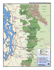
, and Kittitas counties. It has a total area of 1,724,229 acre
s. The Mt. Baker-Snoqualmie National Forest consists of four Ranger Districts. The following are listed geographically from North to South: the Mt. Baker District has two ranger stations located in Glacier
and Sedro-Woolley
; the Darrington Ranger District has two ranger stations located in Darrington
and Verlot
; the Skykomish Ranger District has one ranger station located in Skykomish
; and the Snoqualmie Ranger District has two ranger stations located in North Bend
and Enumclaw
.
Together with the other central Puget Sound
counties, 62% (3.63 million people) of the State's population lives within a 70 miles (112.7 km) drive of the Forests. Another 1.5 million in the Vancouver
, British Columbia metro area are also within easy reach of the northern part of the Forests.
The large population factor, coupled with easy road access, makes the Mt. Baker-Snoqualmie National Forest the second most visited National Forest in the country.
and Glacier Peak
, tower thousands of feet above the adjacent ridges.
The number of glaciers in the forest has decreased from 295 in 1971 to less than 287 in 1998. This is a part of the global phenomenon of glacier retreat
. Forest glaciers have lost between 20 and 40% of their volume between 1984 and 2006. This is due to continued warm conditions and negative mass balance. White Chuck Glacier (Glacier Peak) is no longer on the list of large glaciers, above. It shrank from 3.1 km2 in 1958 to 0.9 km2 in 2002. With the shrinking of the glaciers, summer glacial runoff has been reduced by 65 to 80%. This reduces stream and river flow and sediment
and increases their temperature. Salmon
and many other species are adversely affected by such changes.
. A 1993 Forest Service study estimated that the extent of old growth in the Forest was 643500 acres (260,415.4 ha). In addition, Congressional action since 1964 has established the following wilderness areas:
These pristine areas provide clean water, solitude, and permanent protection to old-growth forests across 42% of the Mt. Baker-Snoqualmie National Forest.
Congress also established the Skagit Wild and Scenic River system in 1978. Its 125 miles (201.2 km) of river on the Skagit
, Cascade
, Sauk
, and Suiattle River
s provide important wildlife habitat and recreation. The Skagit River System is home to one of the largest winter populations of Bald Eagle
s in the United States
.
Mount Baker-Snoqualmie National Forest encompasses much of the North Cascades Ecoregion
, a Level III North American Ecoregion. It includes the following level IV ecoregion
s:
Cascade Range
The Cascade Range is a major mountain range of western North America, extending from southern British Columbia through Washington and Oregon to Northern California. It includes both non-volcanic mountains, such as the North Cascades, and the notable volcanoes known as the High Cascades...
from the Canadian border to the northern boundary of Mount Rainier National Park
Mount Rainier National Park
Mount Rainier National Park is a United States National Park located in southeast Pierce County and northeast Lewis County in Washington state. It was one of the US's earliest National Parks, having been established on March 2, 1899 as the fifth national park in the United States. The park contains...
. Forest headquarters are located in the city of Everett
Everett, Washington
Everett is the county seat of and the largest city in Snohomish County, Washington, United States. Named for Everett Colby, son of founder Charles L. Colby, it lies north of Seattle. The city had a total population of 103,019 at the 2010 census, making it the 6th largest in the state and...
.
Visitation
Mt. Baker-Snoqualmie National Forest covers (in descending order of forestland area) portions of SnohomishSnohomish County, Washington
Snohomish County is a county located in the U.S. state of Washington. It is named after the Snohomish tribe. Since 2000, the county's population has grown from 606,024 to 713,335 residents , making it one of the fastest-growing in the state, ranking third in overall population after King and...
, Whatcom
Whatcom County, Washington
Whatcom County is a county located in the U.S. state of Washington. Its name ultimately derives from the Lummi word Xwotʼqom, meaning "noisy water." As of 2010, the population was 201,140. The county seat is at Bellingham, which is also the county's largest city...
, Skagit
Skagit County, Washington
Skagit County is a county in the U.S. state of Washington. It is named after the Skagit Indian tribe. As of 2010, the population was 116,901. It is included in the Mount Vernon-Anacortes, Washington, Metropolitan Statistical Area...
, King
King County, Washington
King County is a county located in the U.S. state of Washington. The population in the 2010 census was 1,931,249. King is the most populous county in Washington, and the 14th most populous in the United States....
, Snohomish
Snohomish County, Washington
Snohomish County is a county located in the U.S. state of Washington. It is named after the Snohomish tribe. Since 2000, the county's population has grown from 606,024 to 713,335 residents , making it one of the fastest-growing in the state, ranking third in overall population after King and...
, Pierce
Pierce County, Washington
right|thumb|[[Tacoma, Washington|Tacoma]] - Seat of Pierce CountyPierce County is the second most populous county in the U.S. state of Washington. Formed out of Thurston County on December 22, 1852, by the legislature of Oregon Territory...
, and Kittitas counties. It has a total area of 1,724,229 acre
Acre
The acre is a unit of area in a number of different systems, including the imperial and U.S. customary systems. The most commonly used acres today are the international acre and, in the United States, the survey acre. The most common use of the acre is to measure tracts of land.The acre is related...
s. The Mt. Baker-Snoqualmie National Forest consists of four Ranger Districts. The following are listed geographically from North to South: the Mt. Baker District has two ranger stations located in Glacier
Glacier, Washington
Glacier is a census-designated place in Whatcom County, Washington, United States. The population was 211 at the 2010 census.Based on per capita income, Glacier ranks 522nd of 522 areas in the state of Washington to be ranked. Glacier is hoping to change this with the opening of the Glacier...
and Sedro-Woolley
Sedro-Woolley, Washington
Sedro-Woolley is a city in Skagit County, Washington, United States. The population was 10,540 at the 2010 census. It is included in the Mount Vernon–Anacortes, Washington Metropolitan Statistical Area.-History:...
; the Darrington Ranger District has two ranger stations located in Darrington
Darrington, Washington
Darrington is a town in Snohomish County, Washington, United States. The population was 1,347 at the 2010 census.-History:The upper Stillaguamish valley where Darrington is located was once settled by the local Sauk-Suiattle Tribes in the drainage of the Sauk, Suiattle and Whitechuck rivers...
and Verlot
Verlot, Washington
Verlot is a census-designated place in Snohomish County, Washington, United States. The population was 285 at the 2010 census.-Geography:Verlot is located at ....
; the Skykomish Ranger District has one ranger station located in Skykomish
Skykomish, Washington
As of the census of 2000, there were 214 people, 104 households, and 58 families residing in the town. The population density was 623.2 people per square mile . There were 162 housing units at an average density of 471.8 per square mile...
; and the Snoqualmie Ranger District has two ranger stations located in North Bend
North Bend, Washington
North Bend is a city in King County, Washington, United States. The town was made famous by David Lynch's television series Twin Peaks Since the Weyerhaeuser sawmill closed, North Bend has become an upscale bedroom community for the Eastside of Seattle, Washington, with property values more than...
and Enumclaw
Enumclaw, Washington
Enumclaw is a city in King County, Washington, United States. The population was 10,669 at the 2010 census.The Enumclaw Plateau, on which the city resides, was formed by a volcanic mudflow from Mount Rainier approximately 5,700 years ago....
.
Together with the other central Puget Sound
Puget Sound
Puget Sound is a sound in the U.S. state of Washington. It is a complex estuarine system of interconnected marine waterways and basins, with one major and one minor connection to the Strait of Juan de Fuca and the Pacific Ocean — Admiralty Inlet being the major connection and...
counties, 62% (3.63 million people) of the State's population lives within a 70 miles (112.7 km) drive of the Forests. Another 1.5 million in the Vancouver
British Columbia
British Columbia is the westernmost of Canada's provinces and is known for its natural beauty, as reflected in its Latin motto, Splendor sine occasu . Its name was chosen by Queen Victoria in 1858...
, British Columbia metro area are also within easy reach of the northern part of the Forests.
The large population factor, coupled with easy road access, makes the Mt. Baker-Snoqualmie National Forest the second most visited National Forest in the country.
Mountains
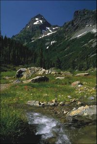
The Mt. Baker-Snoqualmie National Forest contains many scenic and historical points of interest. Mountain tops gradually rise from 5,000 to 6000 feet (1,828.8 m) on the south end of the forest to 7,000 to 8000 feet (2,438.4 m) in the north. Two tall volcanoes, Mount BakerMount Baker
Mount Baker , also known as Koma Kulshan or simply Kulshan, is an active glaciated andesitic stratovolcano in the Cascade Volcanic Arc and the North Cascades of Washington State in the United States. It is the second-most active volcano in the range after Mount Saint Helens...
and Glacier Peak
Glacier Peak
Glacier Peak is the most isolated of the five major stratovolcanoes of the Cascade Volcanic Arc in Washington...
, tower thousands of feet above the adjacent ridges.
Glaciers
The Forest is home to more glaciers and snow fields than any other National Forest outside Alaska. , the largest glaciers (with surface areas greater than 2.5 km2) are:- Mount BakerMount BakerMount Baker , also known as Koma Kulshan or simply Kulshan, is an active glaciated andesitic stratovolcano in the Cascade Volcanic Arc and the North Cascades of Washington State in the United States. It is the second-most active volcano in the range after Mount Saint Helens...
- Roosevelt
- Mazama
- Park
- Boulder
- EastonEaston GlacierEaston Glacier is one of the more prominent alpine glaciers on Mount Baker in the North Cascades Range of Washington state, USA. Named for Charles F. Easton of Bellingham, who did much to preserve the history of Mount Baker, it is positioned on the south face of the mountain and can be accessed by...
- DemingDeming GlacierDeming Glacier is a tributary glacier flowing along the north side of Novasio Ridge to enter Man-o-War Glacier, in the Admiralty Mountains, Victoria Land. Mapped by United States Geological Survey from surveys and U.S. Navy air photos, 1960-63. Named by Advisory Committee on Antarctic Names for...
- ColemanColeman Glacier (Washington)Coleman Glacier is a glacier on Mount Baker in the U.S. state of Washington. It was named for Edmund Thomas Coleman, who made the first ascent of Mount Baker....
- Sentinel PeakSentinel PeakSentinel Peak may refer to:* Sentinel Peak * Sentinel Peak * Sentinel Peak * Sentinel Peak * Sentinel Peak * Sentinel Peak * Sentinel Peak...
- South Cascade GlacierSouth Cascade GlacierSouth Cascade Glacier is a large alpine glacier in the North Cascades of Washington, USA. It is bordered on the east by 8,261-foot Sentinel Peak, and is about 17 miles north of Glacier Peak in the Glacier Peak Wilderness...
- South Cascade Glacier
- Glacier PeakGlacier PeakGlacier Peak is the most isolated of the five major stratovolcanoes of the Cascade Volcanic Arc in Washington...
- Suiattle
- HoneycombHoneycomb GlacierHoneycomb Glacier is a glacier which drains the north and east sides of the mountainous mass surmounted by Mount Whewell, then flows south between that feature and Honeycomb Ridge to Moubray Bay. Named by the New Zealand Geological Survey Antarctic Expedition , 1957–58, for its proximity to...
- White Chuck
The number of glaciers in the forest has decreased from 295 in 1971 to less than 287 in 1998. This is a part of the global phenomenon of glacier retreat
Retreat of glaciers since 1850
The retreat of glaciers since 1850 affects the availability of fresh water for irrigation and domestic use, mountain recreation, animals and plants that depend on glacier-melt, and in the longer term, the level of the oceans...
. Forest glaciers have lost between 20 and 40% of their volume between 1984 and 2006. This is due to continued warm conditions and negative mass balance. White Chuck Glacier (Glacier Peak) is no longer on the list of large glaciers, above. It shrank from 3.1 km2 in 1958 to 0.9 km2 in 2002. With the shrinking of the glaciers, summer glacial runoff has been reduced by 65 to 80%. This reduces stream and river flow and sediment
Sediment
Sediment is naturally occurring material that is broken down by processes of weathering and erosion, and is subsequently transported by the action of fluids such as wind, water, or ice, and/or by the force of gravity acting on the particle itself....
and increases their temperature. Salmon
Salmon
Salmon is the common name for several species of fish in the family Salmonidae. Several other fish in the same family are called trout; the difference is often said to be that salmon migrate and trout are resident, but this distinction does not strictly hold true...
and many other species are adversely affected by such changes.
Conservation
The north and east portions of the Forest are exceptionally rugged and scenic. In 1968 part of the Forest was transferred to the National Park Service as the North Cascades National ParkNorth Cascades National Park
North Cascades National Park is a U.S. National Park located in the state of Washington. The park is the largest of the three National Park Service units that comprise the North Cascades National Park Service Complex. Several national wilderness areas and British Columbia parkland adjoin the...
. A 1993 Forest Service study estimated that the extent of old growth in the Forest was 643500 acres (260,415.4 ha). In addition, Congressional action since 1964 has established the following wilderness areas:
- Glacier PeakGlacier Peak WildernessThe Glacier Peak Wilderness, created by the US Forest Service in 1960 by efforts of the , four years before the 1964 wilderness legislation of the Congress, is located within portions of Chelan County, Snohomish County, and Skagit Counties in the North Cascades of Washington...
- Alpine LakesAlpine Lakes WildernessThe Alpine Lakes Wilderness is a large wilderness area spanning the Cascade Range of Washington state in the United States. The wilderness is located in parts of Wenatchee National Forest and Snoqualmie National Forest, and is approximately bounded by Interstate 90 and Snoqualmie Pass to the south...
- Mount BakerMount Baker WildernessMount Baker Wilderness in northern Washington, USA,contains . Its eastern border is shared with the boundary of the North Cascades National Park for a distance of 40 miles . The Wilderness extends from State Route 20 north to the Canadian border...
- Noisy-DiobsudNoisy-Diobsud WildernessThe Noisy-Diobsud Wilderness is a relatively small wilderness area in northwestern Washington state adjacent to North Cascades National Park. Created in 1984, the Noisy-Diobsud contains of steep valleys, subalpine lakes, and the summits of Anderson Butte and Mount Watson...
- Boulder RiverBoulder River WildernessBoulder River Wilderness is a wilderness area within the Mount Baker-Snoqualmie National Forest in the western Cascade Range of Washington state.-Topography:...
- Henry M. JacksonHenry M. Jackson WildernessThe Henry M. Jackson Wilderness is a U.S. Wilderness Area in the state of Washington, United States.-History:The Henry M. Jackson Wilderness was created by the 1984 Washington Wilderness Act and named after former US Senator Henry M. Jackson of Washington...
- Norse PeakNorse Peak WildernessNorse Peak Wilderness is located in central Washington in the United States. It protects the portion of the Cascade Range north of Chinook Pass , south of Naches Pass , and east of Mt. Rainier National Park. This 50,923 acre wilderness is named for a prominent peak which overlooks Crystal Mountain...
- ClearwaterClearwater WildernessClearwater Wilderness, a small wilderness created by Congress in the 1984 under the 1964 Wilderness Act establishing the National Wilderness Preservation System. It is located in northeast Pierce County, southeast of Tacoma in the South Cascade Range in Washington, US...
- Wild SkyWild Sky WildernessThe Wild Sky Wilderness is a wilderness area in the western Cascade Range of Washington state. The wilderness is within the Mount Baker-Snoqualmie National Forest north of the U.S. Highway 2 towns of Index and Skykomish. The wilderness flanks, but does not include, the North Fork Skykomish River...
These pristine areas provide clean water, solitude, and permanent protection to old-growth forests across 42% of the Mt. Baker-Snoqualmie National Forest.
Congress also established the Skagit Wild and Scenic River system in 1978. Its 125 miles (201.2 km) of river on the Skagit
Skagit River
The Skagit River is a river in southwestern British Columbia in Canada and northwestern Washington in the United States, approximately 150 mi long...
, Cascade
Cascade River (Washington)
The Cascade River is a river in the U.S. state of Washington. It is a tributary of the Skagit River which it joins at the city of Marblemount. It is a National Wild and Scenic River.- South Fork :...
, Sauk
Sauk River (Washington)
The Sauk River is a tributary of the Skagit River, approximately long, in northwestern Washington in the United States. It drains an area of the high Cascade Range in the watershed of Puget Sound north of Seattle. The river is a popular destination for fly fishing...
, and Suiattle River
Suiattle River
The Suiattle River is a river in the U.S. state of Washington.-Course:The Suiattle River originates from the Suiattle Glacier on the slopes of Glacier Peak in the Cascade Range. It flows generally northwest to join the Sauk River north of Darrington. The Sauk River in turn joins the Skagit River,...
s provide important wildlife habitat and recreation. The Skagit River System is home to one of the largest winter populations of Bald Eagle
Bald Eagle
The Bald Eagle is a bird of prey found in North America. It is the national bird and symbol of the United States of America. This sea eagle has two known sub-species and forms a species pair with the White-tailed Eagle...
s in the United States
United States
The United States of America is a federal constitutional republic comprising fifty states and a federal district...
.
Mount Baker-Snoqualmie National Forest encompasses much of the North Cascades Ecoregion
Ecology of the North Cascades
The Ecology of the North Cascades is heavily influenced by the high elevation and rain shadow effects of the mountain range. The North Cascades is a section of the Cascade Range from the South Fork of the Snoqualmie River in Washington, United States, to the confluence of the Thompson and Fraser...
, a Level III North American Ecoregion. It includes the following level IV ecoregion
Ecoregion
An ecoregion , sometimes called a bioregion, is an ecologically and geographically defined area that is smaller than an ecozone and larger than an ecosystem. Ecoregions cover relatively large areas of land or water, and contain characteristic, geographically distinct assemblages of natural...
s:
- Western Hemlock Ecoregion
- Silver Fir Ecoregion
- Subalpine Mountain Hemlock Ecoregion
- Alpine Ecoregion
External links
- MBSNF web site
- The Death of a Glacier Retreat of the White Chuck Glacier