
Washington State Route 123
Encyclopedia
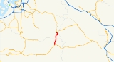
State Route 123 is a state highway
in the Gifford Pinchot National Forest
and Mount Rainier National Park
east of Mount Rainier
in the U.S. state
of Washington. Located in the counties of Lewis
and Pierce
, the 16.34 miles (26.3 km) long roadway extends through a heavily forested canyon from (US 12) to . First established as a branch of in 1923, the designation of SR 123 has changed from a branch of (PSH 5) in 1937 to during the 1964 highway renumbering and SR 123 in 1967. The northern terminus of the highway, Cayuse Pass
, is closed annually and in late 2006, the Hanukkah Eve Wind Storm of 2006
washed out a 10.9 miles (17.54 km) long segment of the roadway.
, in the Gifford Pinchot National Forest
. Paralleling US 12 and the Ohanapecosh River
, the highway crosses Boulder Creek and enters a canyon where the roadway encounters (FR 44), a connector from to Mount Rainier National Park
. The segment of SR 123 in the heavily forested canyon is the busiest along the road, with a daily average of 803 motorists in 2007. Still in the canyon, the roadway exits the Gifford Pinchot National Forest and enters the Mount Rainier National Park. The roadway enters Pierce County
from Lewis County
and passes the Ohanapecosh Visitor Center, located 1900 feet (579.12 m) above sea level
. SR 123 crosses the Laughingwater River and passes Silver Falls and the entrance to Steve Canyon to the trailhead
of the Grove of the Patriarchs Trail. Now following the Chinook Creek, the highway travels into a tunnel
under Seymour Peak and ends at an intersection with at Cayuse Pass
.
 The history of SR 123 begins with the establishment of the Pacific Forest Reserve
in 1893, which became the Mount Rainier Forest Reserve
on in 1897, both included the area near the present highway. The Mount Rainier National Park
was established as the fifth national park
on 2 March 1907. The Mount Rainier National Forest Reserve became the Rainier National Forest
in 1907 and Columbia National Forest
in 1908. In 1923, a renumbering and restructuring of the state highway system
occurred and a branch of , later named the Cayuse Pass
–Yakima
branch, was added to the system. The northern terminus of the roadway at Cayuse Pass became (US 410) during the creation of the United States Numbered Highways
. The Columbia National Forest replaced the Rainier National Forest in 1933. The branch of State Road 5 became the Cayuse Pass branch of (PSH 5) in 1937. Between 1946 and 1959, a ski resort
operated at Cayuse Pass. In 1949, the Columbia National Forest was renamed to the Gifford Pinchot National Forest
to honor a pioneer of the same name
. During the 1964 highway renumbering, the Cayuse Pass branch of PSH 5 became , an auxiliary route
of . SR 14 became on 20 June 1967 and SR 143 became SR 123, while US 410 became . Since 1974, the Washington State Department of Transportation
(WSDOT) has recorded the opening and closing dates of Cayuse Pass. The only season when the pass was not closed was between 1976 and 1977. The earliest closure was on 7 October 1996 and the earliest opening was on 30 March 1992. The latest closure was on 4 January 1990 and the latest opening was 21 June 1996. After the Hanukkah Eve Wind Storm of 2006
, a 10.9 miles (17.54 km) long segment of SR 123, which is only 16.34 miles (26.3 km) long, was washed out and need reconstruction. Construction started on 21 June 2007 and the road reopened on 28 September 2007.
State highways in Washington
In the U.S. state of Washington, the Washington State Department of Transportation maintains a network of over 7000 miles of state highways, including all Interstate and U.S. Highways that pass through the state. The system comprises 8.5% of the state's public road mileage, but carries over half...
in the Gifford Pinchot National Forest
Gifford Pinchot National Forest
Gifford Pinchot National Forest is a U.S. National Forest located in southern Washington, USA. With an area of 1.37 million acres , it extends 116 km along the western slopes of Cascade Range from Mount Rainier National Park to the Columbia River. It includes the 110,000 acre Mount St....
and Mount Rainier National Park
Mount Rainier National Park
Mount Rainier National Park is a United States National Park located in southeast Pierce County and northeast Lewis County in Washington state. It was one of the US's earliest National Parks, having been established on March 2, 1899 as the fifth national park in the United States. The park contains...
east of Mount Rainier
Mount Rainier
Mount Rainier is a massive stratovolcano located southeast of Seattle in the state of Washington, United States. It is the most topographically prominent mountain in the contiguous United States and the Cascade Volcanic Arc, with a summit elevation of . Mt. Rainier is considered one of the most...
in the U.S. state
U.S. state
A U.S. state is any one of the 50 federated states of the United States of America that share sovereignty with the federal government. Because of this shared sovereignty, an American is a citizen both of the federal entity and of his or her state of domicile. Four states use the official title of...
of Washington. Located in the counties of Lewis
Lewis County, Washington
Lewis County is a county located in the U.S. state of Washington. As of 2010, the population was 75,455. The county seat is at Chehalis, and its largest city is Centralia....
and Pierce
Pierce County, Washington
right|thumb|[[Tacoma, Washington|Tacoma]] - Seat of Pierce CountyPierce County is the second most populous county in the U.S. state of Washington. Formed out of Thurston County on December 22, 1852, by the legislature of Oregon Territory...
, the 16.34 miles (26.3 km) long roadway extends through a heavily forested canyon from (US 12) to . First established as a branch of in 1923, the designation of SR 123 has changed from a branch of (PSH 5) in 1937 to during the 1964 highway renumbering and SR 123 in 1967. The northern terminus of the highway, Cayuse Pass
Cayuse Pass
Cayuse Pass is a mountain pass in the Cascade Mountains in the state of Washington.The pass is about 32 miles southeast of Enumclaw on State Route 410. The intersection with State Route 123 is at the pass....
, is closed annually and in late 2006, the Hanukkah Eve Wind Storm of 2006
Hanukkah Eve Wind Storm of 2006
The Hanukkah Eve Wind Storm of 2006 was a powerful Pacific storm that slammed into the Pacific Northwest region of the United States and southern British Columbia, Canada between December 14, 2006 and December 15, 2006...
washed out a 10.9 miles (17.54 km) long segment of the roadway.
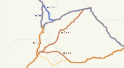
Route description
State Route 123 (SR 123) begins at an intersection with (US 12) northeast of PackwoodPackwood, Washington
Packwood is an unincorporated community located in easternmost Lewis County, Washington.Packwood is located at the intersection of US Highway 12 and Gifford Pinchot National Forest Road 52 . It is located between Mount Rainier National Park to the north and Mt. St. Helens National Volcanic Monument...
, in the Gifford Pinchot National Forest
Gifford Pinchot National Forest
Gifford Pinchot National Forest is a U.S. National Forest located in southern Washington, USA. With an area of 1.37 million acres , it extends 116 km along the western slopes of Cascade Range from Mount Rainier National Park to the Columbia River. It includes the 110,000 acre Mount St....
. Paralleling US 12 and the Ohanapecosh River
Ohanapecosh River
The Ohanapecosh River is a river in the U.S. state of Washington.It is the main headwater tributary of the Cowlitz River, which begins at the confluence of the Ohanapecosh River and the Clear Fork Cowlitz River. The Ohanapecosh originates near Ohanapecosh Glacier on the southeast side of Mount...
, the highway crosses Boulder Creek and enters a canyon where the roadway encounters (FR 44), a connector from to Mount Rainier National Park
Mount Rainier National Park
Mount Rainier National Park is a United States National Park located in southeast Pierce County and northeast Lewis County in Washington state. It was one of the US's earliest National Parks, having been established on March 2, 1899 as the fifth national park in the United States. The park contains...
. The segment of SR 123 in the heavily forested canyon is the busiest along the road, with a daily average of 803 motorists in 2007. Still in the canyon, the roadway exits the Gifford Pinchot National Forest and enters the Mount Rainier National Park. The roadway enters Pierce County
Pierce County, Washington
right|thumb|[[Tacoma, Washington|Tacoma]] - Seat of Pierce CountyPierce County is the second most populous county in the U.S. state of Washington. Formed out of Thurston County on December 22, 1852, by the legislature of Oregon Territory...
from Lewis County
Lewis County, Washington
Lewis County is a county located in the U.S. state of Washington. As of 2010, the population was 75,455. The county seat is at Chehalis, and its largest city is Centralia....
and passes the Ohanapecosh Visitor Center, located 1900 feet (579.12 m) above sea level
Sea level
Mean sea level is a measure of the average height of the ocean's surface ; used as a standard in reckoning land elevation...
. SR 123 crosses the Laughingwater River and passes Silver Falls and the entrance to Steve Canyon to the trailhead
Trailhead
A trailhead is the point at which a trail begins, where the trail is often intended for hiking, biking, horseback riding, or off-road vehicles...
of the Grove of the Patriarchs Trail. Now following the Chinook Creek, the highway travels into a tunnel
Tunnel
A tunnel is an underground passageway, completely enclosed except for openings for egress, commonly at each end.A tunnel may be for foot or vehicular road traffic, for rail traffic, or for a canal. Some tunnels are aqueducts to supply water for consumption or for hydroelectric stations or are sewers...
under Seymour Peak and ends at an intersection with at Cayuse Pass
Cayuse Pass
Cayuse Pass is a mountain pass in the Cascade Mountains in the state of Washington.The pass is about 32 miles southeast of Enumclaw on State Route 410. The intersection with State Route 123 is at the pass....
.
History
Pacific Forest Reserve
The Pacific Forest Reserve was established by the General Land Office in Washington on February 20, 1893 with . On February 22, 1898 the forest was combined with other lands to create the Mount Rainier Forest Reserve, and the name was discontinued....
in 1893, which became the Mount Rainier Forest Reserve
Mount Rainier Forest Reserve
The Mount Rainier Forest Reserve in Washington was established by the General Land Office on February 22, 1898 from the Pacific Forest Reserve and other lands with . In 1905 federal forests were transferred to the U.S. Forest Service. On March 2, 1907 the name was changed to Rainier National Forest...
on in 1897, both included the area near the present highway. The Mount Rainier National Park
Mount Rainier National Park
Mount Rainier National Park is a United States National Park located in southeast Pierce County and northeast Lewis County in Washington state. It was one of the US's earliest National Parks, having been established on March 2, 1899 as the fifth national park in the United States. The park contains...
was established as the fifth national park
National park
A national park is a reserve of natural, semi-natural, or developed land that a sovereign state declares or owns. Although individual nations designate their own national parks differently A national park is a reserve of natural, semi-natural, or developed land that a sovereign state declares or...
on 2 March 1907. The Mount Rainier National Forest Reserve became the Rainier National Forest
Rainier National Forest
Ranier National Forest was established in Washington on March 2, 1907 when its name was changed from Mount Rainier Forest Reserve. On October 13, 1933 Rainer was divided between Columbia, Snoqualmie and Wenatchee National Forests. Its lands exists presently as portions of Mount Baker-Snoqualmie,...
in 1907 and Columbia National Forest
Columbia National Forest
Columbia National Forest was established in Washington by the U.S. Forest Service on July 1, 1908 when it was established from part of Rainier National Forest with . On June 15, 1949 it was renamed Gifford Pinchot National Forest in honor of the forestry pioneer Gifford Pinchot. -External links:** ...
in 1908. In 1923, a renumbering and restructuring of the state highway system
State highways in Washington
In the U.S. state of Washington, the Washington State Department of Transportation maintains a network of over 7000 miles of state highways, including all Interstate and U.S. Highways that pass through the state. The system comprises 8.5% of the state's public road mileage, but carries over half...
occurred and a branch of , later named the Cayuse Pass
Cayuse Pass
Cayuse Pass is a mountain pass in the Cascade Mountains in the state of Washington.The pass is about 32 miles southeast of Enumclaw on State Route 410. The intersection with State Route 123 is at the pass....
–Yakima
Yakima, Washington
Yakima is an American city southeast of Mount Rainier National Park and the county seat of Yakima County, Washington, United States, and the eighth largest city by population in the state itself. As of the 2010 census, the city had a total population of 91,196 and a metropolitan population of...
branch, was added to the system. The northern terminus of the roadway at Cayuse Pass became (US 410) during the creation of the United States Numbered Highways
United States Numbered Highways
The system of United States Numbered Highways is an integrated system of roads and highways in the United States numbered within a nationwide grid...
. The Columbia National Forest replaced the Rainier National Forest in 1933. The branch of State Road 5 became the Cayuse Pass branch of (PSH 5) in 1937. Between 1946 and 1959, a ski resort
Ski resort
A ski resort is a resort developed for skiing and other winter sports. In Europe a ski resort is a town or village in a ski area - a mountainous area, where there are ski trails and supporting services such as hotels and other accommodation, restaurants, equipment rental and a ski lift system...
operated at Cayuse Pass. In 1949, the Columbia National Forest was renamed to the Gifford Pinchot National Forest
Gifford Pinchot National Forest
Gifford Pinchot National Forest is a U.S. National Forest located in southern Washington, USA. With an area of 1.37 million acres , it extends 116 km along the western slopes of Cascade Range from Mount Rainier National Park to the Columbia River. It includes the 110,000 acre Mount St....
to honor a pioneer of the same name
Gifford Pinchot
Gifford Pinchot was the first Chief of the United States Forest Service and the 28th Governor of Pennsylvania...
. During the 1964 highway renumbering, the Cayuse Pass branch of PSH 5 became , an auxiliary route
Auxiliary route
In road transportation, a special route is a prefixed and/or suffixed numbered road that forms a loop or spur of a more dominant route of the same route number and system. The dominant route is generally referred to as the "parent" or "mainline", while special routes are also unofficially or...
of . SR 14 became on 20 June 1967 and SR 143 became SR 123, while US 410 became . Since 1974, the Washington State Department of Transportation
Washington State Department of Transportation
The Washington State Department of Transportation , was established in 1905. The agency, led by a Secretary and overseen by the Governor, is a Washington governmental agency that constructs, maintains, and regulates the use of the state's transportation infrastructure...
(WSDOT) has recorded the opening and closing dates of Cayuse Pass. The only season when the pass was not closed was between 1976 and 1977. The earliest closure was on 7 October 1996 and the earliest opening was on 30 March 1992. The latest closure was on 4 January 1990 and the latest opening was 21 June 1996. After the Hanukkah Eve Wind Storm of 2006
Hanukkah Eve Wind Storm of 2006
The Hanukkah Eve Wind Storm of 2006 was a powerful Pacific storm that slammed into the Pacific Northwest region of the United States and southern British Columbia, Canada between December 14, 2006 and December 15, 2006...
, a 10.9 miles (17.54 km) long segment of SR 123, which is only 16.34 miles (26.3 km) long, was washed out and need reconstruction. Construction started on 21 June 2007 and the road reopened on 28 September 2007.
Major intersections
| County | Location | Mile | Destinations | Notes |
|---|---|---|---|---|
| Lewis Lewis County, Washington Lewis County is a county located in the U.S. state of Washington. As of 2010, the population was 75,455. The county seat is at Chehalis, and its largest city is Centralia.... |
Gifford Pinchot NF Gifford Pinchot National Forest Gifford Pinchot National Forest is a U.S. National Forest located in southern Washington, USA. With an area of 1.37 million acres , it extends 116 km along the western slopes of Cascade Range from Mount Rainier National Park to the Columbia River. It includes the 110,000 acre Mount St.... |
0.00 | Southern terminus | |
| 2.23 | ||||
| 2.60 | Mount Rainier National Park Mount Rainier National Park Mount Rainier National Park is a United States National Park located in southeast Pierce County and northeast Lewis County in Washington state. It was one of the US's earliest National Parks, having been established on March 2, 1899 as the fifth national park in the United States. The park contains... boundary |
|||
| Mt. Rainier NP Mount Rainier National Park Mount Rainier National Park is a United States National Park located in southeast Pierce County and northeast Lewis County in Washington state. It was one of the US's earliest National Parks, having been established on March 2, 1899 as the fifth national park in the United States. The park contains... |
||||
| Pierce Pierce County, Washington right|thumb|[[Tacoma, Washington|Tacoma]] - Seat of Pierce CountyPierce County is the second most populous county in the U.S. state of Washington. Formed out of Thurston County on December 22, 1852, by the legislature of Oregon Territory... |
16.34 | Northern terminus | ||