

Pierce County, Washington
Encyclopedia
U.S. state
A U.S. state is any one of the 50 federated states of the United States of America that share sovereignty with the federal government. Because of this shared sovereignty, an American is a citizen both of the federal entity and of his or her state of domicile. Four states use the official title of...
of Washington. Formed out of Thurston County on December 22, 1852, by the legislature of Oregon Territory
Oregon Territory
The Territory of Oregon was an organized incorporated territory of the United States that existed from August 14, 1848, until February 14, 1859, when the southwestern portion of the territory was admitted to the Union as the State of Oregon. Originally claimed by several countries , the region was...
, it was named for U.S. President
President of the United States
The President of the United States of America is the head of state and head of government of the United States. The president leads the executive branch of the federal government and is the commander-in-chief of the United States Armed Forces....
Franklin Pierce
Franklin Pierce
Franklin Pierce was the 14th President of the United States and is the only President from New Hampshire. Pierce was a Democrat and a "doughface" who served in the U.S. House of Representatives and the Senate. Pierce took part in the Mexican-American War and became a brigadier general in the Army...
.
As of 2010 Census, the population was 795,225. The county seat is Tacoma
Tacoma, Washington
Tacoma is a mid-sized urban port city and the county seat of Pierce County, Washington, United States. The city is on Washington's Puget Sound, southwest of Seattle, northeast of the state capital, Olympia, and northwest of Mount Rainier National Park. The population was 198,397, according to...
, on Commencement Bay
Commencement Bay
Commencement Bay is a bay of Puget Sound in the U.S. state of Washington. The city of Tacoma is located on the bay, with the Port of Tacoma occupying the southeastern end. A line drawn from Point Defiance in the southwest to Browns Point in the northeast serves to mark the generally accepted...
, which is also the county's largest city.
Pierce County is notable for being home to the Mount Rainier
Mount Rainier
Mount Rainier is a massive stratovolcano located southeast of Seattle in the state of Washington, United States. It is the most topographically prominent mountain in the contiguous United States and the Cascade Volcanic Arc, with a summit elevation of . Mt. Rainier is considered one of the most...
volcano
Volcano
2. Bedrock3. Conduit 4. Base5. Sill6. Dike7. Layers of ash emitted by the volcano8. Flank| 9. Layers of lava emitted by the volcano10. Throat11. Parasitic cone12. Lava flow13. Vent14. Crater15...
, the tallest mountain in the Cascade Range
Cascade Range
The Cascade Range is a major mountain range of western North America, extending from southern British Columbia through Washington and Oregon to Northern California. It includes both non-volcanic mountains, such as the North Cascades, and the notable volcanoes known as the High Cascades...
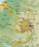
. Its most recent recorded eruption was between 1820 and 1854. There is no imminent risk of eruption, but geologists expect that the volcano will erupt again. If this should happen, parts of Pierce County and the Puyallup Valley would be at risk from lahar
Lahar
A lahar is a type of mudflow or debris flow composed of a slurry of pyroclastic material, rocky debris, and water. The material flows down from a volcano, typically along a river valley. The term is a shortened version of "berlahar" which originated in the Javanese language of...
s, lava
Lava
Lava refers both to molten rock expelled by a volcano during an eruption and the resulting rock after solidification and cooling. This molten rock is formed in the interior of some planets, including Earth, and some of their satellites. When first erupted from a volcanic vent, lava is a liquid at...
, or pyroclastic flow
Pyroclastic flow
A pyroclastic flow is a fast-moving current of superheated gas and rock , which reaches speeds moving away from a volcano of up to 700 km/h . The flows normally hug the ground and travel downhill, or spread laterally under gravity...
s. The Mount Rainier Volcano Lahar Warning System was established in 1998 to assist in the evacuation of the Puyallup River
Puyallup River
The Puyallup River is a river in the U.S. state of Washington. About long, it is formed by glaciers on the west side of Mount Rainier. It flows generally northwest, emptying into Commencement Bay, part of Puget Sound...
valley in case of eruption.
Geography
According to the U.S. Census BureauUnited States Census Bureau
The United States Census Bureau is the government agency that is responsible for the United States Census. It also gathers other national demographic and economic data...
, the county has a total area of 1,806 square miles (4,679 km²), of which 1,679 square miles (4,348 km²) is land and 128 square miles (330 km²) (7.06%) is water. The highest natural point in Washington, Mount Rainier
Mount Rainier
Mount Rainier is a massive stratovolcano located southeast of Seattle in the state of Washington, United States. It is the most topographically prominent mountain in the contiguous United States and the Cascade Volcanic Arc, with a summit elevation of . Mt. Rainier is considered one of the most...
at 14,410 feet (4,392 m), is located in Pierce County.
Geographic features
- Anderson Island
- Carbon RiverCarbon RiverThe Carbon River is a river in the U.S. state of Washington. It flows about 30 miles from its source, the Carbon Glacier on Mount Rainier, to join the Puyallup River at Orting....
- Cascade RangeCascade RangeThe Cascade Range is a major mountain range of western North America, extending from southern British Columbia through Washington and Oregon to Northern California. It includes both non-volcanic mountains, such as the North Cascades, and the notable volcanoes known as the High Cascades...
- Case InletCase InletCase Inlet, in southern Puget Sound in the U.S. state of Washington, is an arm of water between Key Peninsula on the east and Hartstine Island on the west. Its northern end, called North Bay, reaches nearly to Hood Canal, creating the defining isthmus of Kitsap Peninsula. Case Inlet is the boundary...
- Commencement BayCommencement BayCommencement Bay is a bay of Puget Sound in the U.S. state of Washington. The city of Tacoma is located on the bay, with the Port of Tacoma occupying the southeastern end. A line drawn from Point Defiance in the southwest to Browns Point in the northeast serves to mark the generally accepted...
- Fox IslandFox Island, WashingtonFox Island is a census-designated place in Pierce County, Washington, United States, on an island of the same name in Puget Sound. It is located approximately five miles from Gig Harbor. The island was named Fox by Charles Wilkes during the United States Exploring Expedition, to honor J.L. Fox, an...
- Herron IslandHerron IslandHerron Island is an island in central Case Inlet in the southern part of Puget Sound in the state of Washington, USA. The Pierce County island has a land area of 1.2326 km² and a population of 152 persons as of the 2000 census....
- Ketron IslandKetron IslandKetron Island is an island in southern Puget Sound in Pierce County in the state of Washington, USA. It lies between the mainland near the city of Steilacoom and Anderson Island near the extreme south end of Puget Sound...
- Key PeninsulaKey PeninsulaThe Key Peninsula is a finger of land in Puget Sound, Washington, United States . It is approximately long and extends south from the Kitsap Peninsula. It is part of Pierce County, Washington. Some of its towns include:...
- Lake Tapps (Washington)Lake Tapps (Washington)Lake Tapps is a reservoir in Pierce County, Washington. It was created in 1911 by Puget Sound Energy and operated for hydroelectric power until it ceased power production in 2004...
- McNeil IslandMcNeil IslandMcNeil Island is an island in western Puget Sound, located just west of Steilacoom, Washington, with a land area of 17.177 km² . It lies just north of Anderson Island. Fox Island is to the north, across Carr Inlet. To the west McNeil Island is separated from Key Peninsula by Pitt Passage. The...
- Mount RainierMount RainierMount Rainier is a massive stratovolcano located southeast of Seattle in the state of Washington, United States. It is the most topographically prominent mountain in the contiguous United States and the Cascade Volcanic Arc, with a summit elevation of . Mt. Rainier is considered one of the most...
, highest point in Pierce County - Nisqually RiverNisqually RiverThe Nisqually River is a river in west central Washington in the United States, approximately long. It drains part of the Cascade Range southwest of Tacoma, including the southern slope of Mount Rainier, and empties into the southern end of Puget Sound....
- Puget SoundPuget SoundPuget Sound is a sound in the U.S. state of Washington. It is a complex estuarine system of interconnected marine waterways and basins, with one major and one minor connection to the Strait of Juan de Fuca and the Pacific Ocean — Admiralty Inlet being the major connection and...
- Puyallup RiverPuyallup RiverThe Puyallup River is a river in the U.S. state of Washington. About long, it is formed by glaciers on the west side of Mount Rainier. It flows generally northwest, emptying into Commencement Bay, part of Puget Sound...
- Raft IslandRaft IslandRaft Island is a private island in the Pierce County community of Rosedale, Washington, USA. Gig Harbor, Washington is the nearest incorporated town, although unincorporated Artondale is much closer. There are 1,694 housing units and a population of 4,107 persons on the island as of the 2010 census...
- Tacoma NarrowsTacoma NarrowsThe Tacoma Narrows , a strait, is part of Puget Sound in the U.S. state of Washington. A navigable maritime waterway between glacial landforms, the Narrows separates the Kitsap Peninsula from the city of Tacoma....
Pierce County also contains the Clearwater Wilderness
Clearwater Wilderness
Clearwater Wilderness, a small wilderness created by Congress in the 1984 under the 1964 Wilderness Act establishing the National Wilderness Preservation System. It is located in northeast Pierce County, southeast of Tacoma in the South Cascade Range in Washington, US...
area.
Adjacent counties
- King County, WashingtonKing County, WashingtonKing County is a county located in the U.S. state of Washington. The population in the 2010 census was 1,931,249. King is the most populous county in Washington, and the 14th most populous in the United States....
- north - Yakima County, WashingtonYakima County, WashingtonYakima County is the second largest county by area in the U.S. state of Washington. It is named after the Yakama tribe of Native Americans. In the 2010 census, its population was 243,231...
- east - Lewis County, WashingtonLewis County, WashingtonLewis County is a county located in the U.S. state of Washington. As of 2010, the population was 75,455. The county seat is at Chehalis, and its largest city is Centralia....
- south - Thurston County, Washington - west/southwest
- Mason County, Washington - west/northwest
- Kitsap County, WashingtonKitsap County, WashingtonKitsap County is a county located in the U.S. state of Washington, named after Chief Kitsap of the Suquamish tribe. As of 2011 state estimate, its population was 253,900. Its county seat is at Port Orchard, and its largest city is Bremerton....
- north/northwest
National protected areas
- Mount Baker-Snoqualmie National ForestMount Baker-Snoqualmie National ForestThe Mount Baker-Snoqualmie National Forest in Washington extends more than along the western slopes of the Cascade Range from the Canadian border to the northern boundary of Mount Rainier National Park. Forest headquarters are located in the city of Everett....
(part) - Mount Rainier National ParkMount Rainier National ParkMount Rainier National Park is a United States National Park located in southeast Pierce County and northeast Lewis County in Washington state. It was one of the US's earliest National Parks, having been established on March 2, 1899 as the fifth national park in the United States. The park contains...
(part) - Nisqually National Wildlife RefugeNisqually National Wildlife RefugeThe Nisqually National Wildlife Refuge is a wildlife preserve operated by the United States Fish and Wildlife Service on the Nisqually River Delta near Puget Sound in northeastern Thurston County, Washington and northwestern Pierce County, Washington...
(part)
Demographics
As of the censusCensus
A census is the procedure of systematically acquiring and recording information about the members of a given population. It is a regularly occurring and official count of a particular population. The term is used mostly in connection with national population and housing censuses; other common...
of 2000, there were 700,820 people, 260,800 households, and 180,212 families residing in the county. The population density
Population density
Population density is a measurement of population per unit area or unit volume. It is frequently applied to living organisms, and particularly to humans...
was 417 people per square mile (161/km²). There were 277,060 housing units at an average density of 165 per square mile (64/km²). The racial makeup of the county was 78.39% White
Race (United States Census)
Race and ethnicity in the United States Census, as defined by the Federal Office of Management and Budget and the United States Census Bureau, are self-identification data items in which residents choose the race or races with which they most closely identify, and indicate whether or not they are...
, 6.95% Black
Race (United States Census)
Race and ethnicity in the United States Census, as defined by the Federal Office of Management and Budget and the United States Census Bureau, are self-identification data items in which residents choose the race or races with which they most closely identify, and indicate whether or not they are...
or African American
Race (United States Census)
Race and ethnicity in the United States Census, as defined by the Federal Office of Management and Budget and the United States Census Bureau, are self-identification data items in which residents choose the race or races with which they most closely identify, and indicate whether or not they are...
, 1.42% Native American
Race (United States Census)
Race and ethnicity in the United States Census, as defined by the Federal Office of Management and Budget and the United States Census Bureau, are self-identification data items in which residents choose the race or races with which they most closely identify, and indicate whether or not they are...
, 5.08% Asian
Race (United States Census)
Race and ethnicity in the United States Census, as defined by the Federal Office of Management and Budget and the United States Census Bureau, are self-identification data items in which residents choose the race or races with which they most closely identify, and indicate whether or not they are...
, 0.85% Pacific Islander
Race (United States Census)
Race and ethnicity in the United States Census, as defined by the Federal Office of Management and Budget and the United States Census Bureau, are self-identification data items in which residents choose the race or races with which they most closely identify, and indicate whether or not they are...
, 2.20% from other races
Race (United States Census)
Race and ethnicity in the United States Census, as defined by the Federal Office of Management and Budget and the United States Census Bureau, are self-identification data items in which residents choose the race or races with which they most closely identify, and indicate whether or not they are...
, and 5.11% from two or more races. 5.51% of the population were Hispanic
Race (United States Census)
Race and ethnicity in the United States Census, as defined by the Federal Office of Management and Budget and the United States Census Bureau, are self-identification data items in which residents choose the race or races with which they most closely identify, and indicate whether or not they are...
or Latino
Race (United States Census)
Race and ethnicity in the United States Census, as defined by the Federal Office of Management and Budget and the United States Census Bureau, are self-identification data items in which residents choose the race or races with which they most closely identify, and indicate whether or not they are...
of any race. 16.1% were of German, 8.6% Irish
Irish people
The Irish people are an ethnic group who originate in Ireland, an island in northwestern Europe. Ireland has been populated for around 9,000 years , with the Irish people's earliest ancestors recorded having legends of being descended from groups such as the Nemedians, Fomorians, Fir Bolg, Tuatha...
, 8.2% English
English people
The English are a nation and ethnic group native to England, who speak English. The English identity is of early mediaeval origin, when they were known in Old English as the Anglecynn. England is now a country of the United Kingdom, and the majority of English people in England are British Citizens...
, 6.3% United States
United States
The United States of America is a federal constitutional republic comprising fifty states and a federal district...
or American and 6.2% Norwegian ancestry according to Census 2000.
There were 260,800 households out of which 35.90% had children under the age of 18 living with them, 52.80% were married couples
Marriage
Marriage is a social union or legal contract between people that creates kinship. It is an institution in which interpersonal relationships, usually intimate and sexual, are acknowledged in a variety of ways, depending on the culture or subculture in which it is found...
living together, 11.80% had a female householder with no husband present, and 30.90% were non-families. 24.30% of all households were made up of individuals and 7.60% had someone living alone who was 65 years of age or older. The average household size was 2.60 and the average family size was 3.10.
In the county, the population was spread out with 27.20% under the age of 18, 9.80% from 18 to 24, 31.30% from 25 to 44, 21.50% from 45 to 64, and 10.20% who were 65 years of age or older. The median age was 34 years. For every 100 females there were 98.90 males. For every 100 females age 18 and over, there were 96.70 males.
The median income for a household in the county was $45,204, and the median income for a family was $52,098. Males had a median income of $38,510 versus $28,580 for females. The per capita income
Per capita income
Per capita income or income per person is a measure of mean income within an economic aggregate, such as a country or city. It is calculated by taking a measure of all sources of income in the aggregate and dividing it by the total population...
for the county was $20,948. About 7.50% of families and 10.50% of the population were below the poverty line, including 13.20% of those under age 18 and 7.20% of those age 65 or over.
Politics
| Year | Democrat Democratic Party (United States) The Democratic Party is one of two major contemporary political parties in the United States, along with the Republican Party. The party's socially liberal and progressive platform is largely considered center-left in the U.S. political spectrum. The party has the lengthiest record of continuous... |
Republican Republican Party (United States) The Republican Party is one of the two major contemporary political parties in the United States, along with the Democratic Party. Founded by anti-slavery expansion activists in 1854, it is often called the GOP . The party's platform generally reflects American conservatism in the U.S... |
|---|---|---|
| 2008 | 54.9% 181,824 | 42.8% 141,673 |
| 2004 | 50.5% 158,231 | 48.1% 150,783 |
| 2000 | 51.4% 138,249 | 44.1% 118,431 |
| 1996 | 50.6% 120,893 | 37.4% 89,295 |
| 1992 | 42.4% 102,243 | 32.1% 77,410 |
| 1988 | 49.7% 96,688 | 48.4% 94,167 |
Residents of Pierce County, Washington, live in one of three U.S. congressional districts:
- Washington's 8th congressional districtWashington's 8th congressional districtWashington's 8th congressional district includes most of the region known as the Eastside and the mostly rural eastern parts of King and Pierce counties. It is currently represented in the U.S. House of Representatives by Republican Dave Reichert....
covers the eastern half of the county, from Orting east to Mt. Rainier. The 8th district has been represented since 2005 by Dave ReichertDave ReichertDavid George Reichert is the U.S. Representative for , serving since 2005. He is a member of the Republican Party. He previously served as Sheriff of King County, Washington.-Early life, education and career:...
(RepublicanRepublican Party (United States)The Republican Party is one of the two major contemporary political parties in the United States, along with the Democratic Party. Founded by anti-slavery expansion activists in 1854, it is often called the GOP . The party's platform generally reflects American conservatism in the U.S...
). - Washington's 9th congressional districtWashington's 9th congressional districtWashington's 9th congressional district encompasses a long, somewhat narrow area in western Washington that largely follows Interstate 5 through the densely populated central Puget Sound region, from Olympia in the south to Renton in the north. Since 1997, the 9th District has been represented in...
, which cuts a swath through the county's midsection and includes the county's southwestern portion, is bordered by the Nisqually River and includes Fort Lewis and McChord Air Force Base. The 9th district has been represented since 1997 by Adam SmithAdam Smith (politician)David Adam Smith , American politician, has been a Democratic member of the United States House of Representatives since 1997, representing Washington's 9th congressional district.-Biography:...
(DemocratDemocratic Party (United States)The Democratic Party is one of two major contemporary political parties in the United States, along with the Republican Party. The party's socially liberal and progressive platform is largely considered center-left in the U.S. political spectrum. The party has the lengthiest record of continuous...
). - Washington's 6th congressional districtWashington's 6th congressional districtWashington's 6th congressional district encompasses the Olympic Peninsula, most of the Kitsap Peninsula, and most of the city of Tacoma. Since 1977, the 6th District has been represented in the U.S. House of Representatives by Norm Dicks, a Democrat from Bremerton.Established after the 1930 U.S...
includes the city of Tacoma, Gig Harbor, the Key Peninsula, and part of Lakewood. The 6th has been represented since 1977 by Norm Dicks (Democrat).
Economy
Joint Base Lewis-McChordJoint Base Lewis-McChord
Joint Base Lewis-McChord is a United States military facility located south-southwest of Tacoma, Washington. The facility is under the jurisdiction of the United States Army Joint Base Garrison, Joint Base Lewis-McChord....
contributes more than 42,000 military and civilian jobs to the local economy.
Pierce County agriculture has been an instrumental part of the local economy for almost 150 years. However, in the last half century much of the county's farmland has been transformed into residential areas. Pierce County has taken aggressive steps to reverse this trend; the county recently created the Pierce County Farm Advisory Commission. This advisory board helps local farmers with the interpretation of land use regulations as well as the promotion of local produce. The creation of the Pierce County Farm Advisory Commission will hopefully save the remaining 48,000 acres of Pierce County farmland. Despite the loss of farmland, Pierce County continues to produce about 50% of the United States' rhubarb
Rhubarb
Rhubarb is a group of plants that belong to the genus Rheum in the family Polygonaceae. They are herbaceous perennial plants growing from short, thick rhizomes. They have large leaves that are somewhat triangular-shaped with long fleshy petioles...
.
Arts and culture
Pierce County boasts a thriving arts and culture community. Arts organizations within Pierce County include: the Broadway Center for the Performing Arts, Grand Cinema, Lakewood Playhouse, Museum of Glass, Northwest Sinfonietta, Speakeasy Arts Cooperative, Tacoma Art Museum, Tacoma Little Theater, Tacoma Concert Band, Tacoma Musical Playhouse, Tacoma Opera, Tacoma Philharmonic, Tacoma Symphony, Dance Theater Northwest, Washington State History MuseumWashington State History Museum
The Washington State History Museum is located in downtown Tacoma, Washington. It is owned and operated by the Washington State Historical Society under the official approval of the Washington State Legislature....
and others. Wintergrasshttp://www.acousticsound.org, a yearly festival that takes place over several days in February every year, was honored in 2005 as "Bluegrass Festival of the year in 2005". (It was moved to Bellevue
Bellevue, Washington
Bellevue is a city in the Eastside region of King County, Washington, United States, across Lake Washington from Seattle. Long known as a suburb or satellite city of Seattle, it is now categorized as an edge city or a boomburb. The population was 122,363 at the 2010 census.Downtown Bellevue is...
starting in 2010.) The City of Tacoma celebrates "Art at Work" month every November to encourage participation and support for the arts community in that city. ArtsFund, a regional United Arts Fund, has been supporting the arts community in Pierce County since 1969.
There are several good city guides to the arts and culture scene: TacomaMama.com, Exit 133, TakePartInArt.org, and FeedTacoma.com are among the most popular.
Every year in April, the Pierce County Daffodil Festival and Parade is held. Established in 1934, it is one of the regions prominent attractions. It is also home to the Puyallup Fair
Puyallup Fair
The Puyallup Fair is the largest single attraction held annually in the state of Washington. The fair continually ranks in the top ten largest fairs in the United States...
, held every September. The Puyallup Fair is nationally accredited and recognized.
Education
Public school districts in Pierce County include Tacoma Public SchoolsTacoma Public Schools
Tacoma Public Schools is the main school district for Tacoma, Washington, USA.-District facts:-2004-2005 Budget:-School board:*Kurt Miller, President, Term expires: November, 2009*Connie Rickman, Vice President, Term expires: November, 2009...
, Auburn-Dieringer School District, Bethel School District, Carbonado School District, Clover Park School District, Eatonville School District, Fife School District, Franklin Pierce School District, Orting School District, Peninsula School District, Puyallup School District, Steilacoom Historical Schools District, Sumner School District, University Place School District, White River School District, and Yelm School District (map of districts: http://yakima.co.pierce.wa.us/MapGallery/documents/SchoolDistricts_Atlas.pdf). Private schools include the Cascade Christian Schools
Cascade Christian Schools
Cascade Christian Schools are a small group of private schools in Pierce County, Washington. They comprise three elementary school campuses several early childhood centers, and a junior/senior high school, providing education for roughly 1500 students...
group, Life Christian School and Academy, Bellarmine, and Charles Wright Academy. Libraries include the Pierce County Library System
Pierce County Library System
The Pierce County Library System is a library system serving the residents of Pierce County, Washington. As of 2011, PCLS has 17 branches and several bookmobiles serving more than 550,000 people in unincorporated Pierce County and 15 cities and towns which have annexed to the system for library...
, the Tacoma Library System, and the Puyallup Public Library.
Higher education
Tacoma Community College was established in 1965 and is accredited by the Northwest Commission on Colleges and Universities. It is one of 34 Washington community and technical colleges. It is supported through state funds and resources from the Tacoma Community College Foundation. Over 15,000 students enroll at TCC annually (2006–2007). Nearly 1/2 million students have attended TCC since its opening. About 40% of TCC students plan to transfer to universities.Other institutions include Pierce Community College, University of Puget Sound (UPS), Pacific Lutheran University (PLU), Central Washington University Extension centers (CWU), and University of Washington-Tacoma (UW-T).
Government of Pierce County
Pierce County has adopted and is governed by a Charter. This is allowed by section 4 of Article XI of the Washington constitution. Its legislative branch of government consists of a seven member partisan council, led by Chairman Roger Bush (R-District 3); its judicial branch by 23 departments of the Superior Court; and its executive branch by five separate offices:
+ 1 Executive Pat McCarthy
+ 2 Assessor-Treasurer Dale Washam
+ 3 Auditor Julie Anderson
+ 4 Prosecuting Attorney Mark Lindquist
+ 5 Sheriff Paul Pastor, Jr. (non-partisan)
Many charter amendments have been on the ballot in the last five years, but sequential numbering does not carryover from year-to-year.
Transportation
The Port of TacomaPort of Tacoma
The Port of Tacoma is an independent seaport located in Tacoma, Washington. The port was created by a vote of Pierce County citizens on November 5, 1918...
is the sixth busiest container port in North America, and one of the 25 busiest in the world, and it plays an important part in the local economy. This deep-water port covers 2,400 acres (9.7 km²) and offers a combination of facilities and services including 34 deepwater berths, two million square feet (190,000 m²) of warehouse and office space, and 131 acres (530,000 m²) of industrial yard. One economic impact study showed that more the 28,000 jobs in Pierce County are related to the Port activities.
Pierce County's official transportation provider is Pierce Transit
Pierce Transit
Pierce Transit, in full the Pierce County Public Transportation Benefit Area Corporation, is the public transit authority of Pierce County, Washington. Based in Lakewood, Washington, it was founded in 1979...
. It provides bus
Bus
A bus is a road vehicle designed to carry passengers. Buses can have a capacity as high as 300 passengers. The most common type of bus is the single-decker bus, with larger loads carried by double-decker buses and articulated buses, and smaller loads carried by midibuses and minibuses; coaches are...
es, paratransit, and rideshare vehicles. The regional Sound Transit
Sound Transit
Sound Transit has been the popular name of Washington state's Central Puget Sound Regional Transit Authority since September 19, 1999. It was formed in 1996 by the Snohomish, King, and Pierce County Councils...
runs a light rail
Light rail
Light rail or light rail transit is a form of urban rail public transportation that generally has a lower capacity and lower speed than heavy rail and metro systems, but higher capacity and higher speed than traditional street-running tram systems...
line through downtown Tacoma, and provides several regional express bus
Bus
A bus is a road vehicle designed to carry passengers. Buses can have a capacity as high as 300 passengers. The most common type of bus is the single-decker bus, with larger loads carried by double-decker buses and articulated buses, and smaller loads carried by midibuses and minibuses; coaches are...
es. Also, Intercity Transit
Intercity Transit
Intercity Transit is a public transportation service organized as a municipal corporation that services Lacey, Olympia, Tumwater, and Yelm, Washington, an area of approximately...
provides transportation between Tacoma, Lakewood
Lakewood, Washington
Lakewood is a city in Pierce County, Washington, United States. The population was 58,163 at the 2010 census.-History:Lakewood was officially incorporated on February 28, 1996. Historical names include Lakewood Center and Lakes District...
, and Thurston County.
Major highways
 Interstate 5Interstate 5 in WashingtonInterstate 5 in Washington is a highway in the U.S. state of Washington that extends from its border with Oregon to its border with Canada...
 Interstate 705Interstate 705Interstate 705 is a short Interstate Highway spur route of Interstate 5 located entirely within Tacoma, Pierce, Washington, United States. I-705 serves as the connector between Interstate 5, Downtown Tacoma, Tacoma's waterfront, North Tacoma, and the Tacoma Dome...
 State Route 16 (Tacoma Narrows BridgeTacoma Narrows BridgeThe Tacoma Narrows Bridge is a pair of twin suspension bridges in the U.S. state of Washington, which carry State Route 16 across the Tacoma Narrows strait of Puget Sound between Tacoma and the Kitsap Peninsula...
) State Route 167
 State Route 410Washington State Route 410State Route 410 is a long state highway that traverses Pierce, King, and Yakima counties in the U.S. state of Washington. It begins at an interchange with SR 167 in Sumner and travels southeast across the Cascade Range to a junction with U.S. Route 12 in Naches...
 State Route 512
Crime
As of 2006, 38% of the methamphetamineMethamphetamine
Methamphetamine is a psychostimulant of the phenethylamine and amphetamine class of psychoactive drugs...
labs (138 sites) cleaned up by the Washington Department of Ecology
Washington Department of Ecology
The Washington Department of Ecology, or simply, Ecology, is an environmental regulatory agency for the State of Washington. The department administers laws and regulations pertaining to the areas of water quality, water rights and water resources, shoreline management, toxics clean-up, nuclear...
were in Pierce County. This reduction from a high of 589 labs in 2001 comes in part to a new law restricting the sale of pseudoephedrine
Pseudoephedrine
Pseudoephedrine is a sympathomimetic drug of the phenethylamine and amphetamine chemical classes. It is used as a nasal/sinus decongestant and stimulant, or as a wakefulness-promoting agent....
and in part due to tougher prison sentences for methamphetamine producers.
See also
- National Register of Historic Places listings in Pierce County, Washington