

Bypass (road)
Encyclopedia
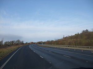
A bypass is a road
or highway
that avoids or "bypasses" a built-up area, town, or village, to let through traffic
flow without interference from local traffic, to reduce congestion
in the built-up area, and to improve road safety.
If there are no strong land use controls, buildings are often built in town along a bypass, converting it into an ordinary town road, and the bypass may eventually become as congested as the local streets it was intended to avoid. Shopping centres and some other companies often are built there for ease of access, while homes are often avoided for noise reasons.
 The idea of bypasses predates the use of motor vehicles. The first (northern) London
bypass, the present Marylebone Road
between Paddington
and Islington
, was started in 1756.
Bypasses can take many years to gain planning approval and funding. Many towns and villages have been campaigning for bypasses for over 30 years e.g. Banwell
in North Somerset
. Bypass routes are often controversial — by definition they require the building of a road carrying heavy traffic where no road previously existed. This creates a conflict between those who support a bypass to reduce congestion in a built up area, and those who oppose the development of (often rural) undeveloped land.
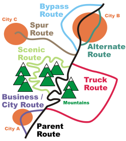
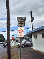 In the United States, bypass routes are a type of special route used on an alternative routing of a highway around a town when the main route of the highway goes through the town. The original designation of these routes were "truck routes" to divert through truck traffic away from the town, but the designation was changed to "bypass" in 1959-1960 by AASHTO
. However, many "Truck" routes remain where the mainline of the highway is prohibited for trucks.
In a few cases, both a bypass and a business route
exist, both with auxiliary signs (i.e. U.S. Highway 60 in Lexington, Kentucky
). Bypass routes are less common than business routes. Many of those that existed before the era of Interstate highways have lost their old designations. For example in Missouri
, the old bypass route of U.S. Highway 71 to the east of Kansas City, Missouri
was decertified
as Interstate 435 supplanted, the remainder that existed as suburban surface route becoming Missouri State Highway 291
; around St. Louis, Missouri
, what had been Bypass U.S. Highway 50 was absorbed into a diversion of U.S. Highway 50 from Interstate 44
and Interstate 64
.
In the Interstate highway system in the United States, bypasses and loops are designated with a three digit number beginning with an even digit. Note, however, that this pattern is inconsistent enough that, as in greater Des Moines, Iowa
the genuine bypass is the main route (in that case, Interstate 35
and Interstate 80
, and the loop into downtown Des Moines is Interstate 235
; or as in Omaha, Nebraska
, where Interstate 480
traverses their downtown area
, which is bypassed by Interstate 80
and Interstate 680
and also Interstate 95
which goes through Philadelphia, Pennsylvania
and Interstate 295 is the bypass around Philly which goes into New Jersey
.
Another meaning of the term bypass route (usually simply called a bypass) is a highway that was constructed to bypass an area that is often congested with traffic. This includes Interstate highway beltways and U.S. Highways constructed to circumvent downtown areas. Examples of these are U.S. Route 60
bypassing Williamsburg, Virginia
, U.S. Routes 31
and 20
bypassing metro South Bend, Indiana
(the St. Joseph Valley Parkway
), and Interstate 75
bypassing Tampa
and St. Petersburg, Florida
. These bypasses usually carry mainline routes rather than auxiliary "bypass" routes.
The first bypass route in the United States was completed in 1958, as Alabama State Route 210 (Ross Clark Circle) in Dothan, Alabama.
uses the term "diversion".
, many bypasses have been built, both as motorways and ordinary roads. Many cities and villages however still have main roads right through them. Municipality
administrations are often lobbying to have a bypass for safety, noise and air quality reasons. In the northern parts of Sweden fewer bypasses have been built, especially in the sparsely populated interior. Here, municipality administrations are often lobbying against bypasses, since they are afraid of losing income from road travellers.
, the East Kowloon Corridor
, the West Kowloon Corridor
, and the Lung Cheung
and Ching Cheung Road
s. Later ones are named directly as bypasses, such as Kwun Tong Bypass
, Hung Hom Bypass, and the Ma On Shan Bypass. Other bypasses include the Tai Po Section of the Tolo Highway
, the section within the Tuen Mun New Town of the Tuen Mun Road
, the Yuen Long Highway
, and the West Kowloon Highway
. The Central-Wan Chai Bypass
, which costs HK$28.1 billion, will be a series of tunnels between Central
and Causeway Bay
.
, Arthur Dent's
home is destroyed to make way for a bypass. A few minutes later, the entire Earth
is destroyed by the Vogon
s to make way for a hyperspace bypass. In chapter 1, Adams explained what a bypass was:
Road
A road is a thoroughfare, route, or way on land between two places, which typically has been paved or otherwise improved to allow travel by some conveyance, including a horse, cart, or motor vehicle. Roads consist of one, or sometimes two, roadways each with one or more lanes and also any...
or highway
Highway
A highway is any public road. In American English, the term is common and almost always designates major roads. In British English, the term designates any road open to the public. Any interconnected set of highways can be variously referred to as a "highway system", a "highway network", or a...
that avoids or "bypasses" a built-up area, town, or village, to let through traffic
Traffic
Traffic on roads may consist of pedestrians, ridden or herded animals, vehicles, streetcars and other conveyances, either singly or together, while using the public way for purposes of travel...
flow without interference from local traffic, to reduce congestion
Traffic congestion
Traffic congestion is a condition on road networks that occurs as use increases, and is characterized by slower speeds, longer trip times, and increased vehicular queueing. The most common example is the physical use of roads by vehicles. When traffic demand is great enough that the interaction...
in the built-up area, and to improve road safety.
If there are no strong land use controls, buildings are often built in town along a bypass, converting it into an ordinary town road, and the bypass may eventually become as congested as the local streets it was intended to avoid. Shopping centres and some other companies often are built there for ease of access, while homes are often avoided for noise reasons.
United Kingdom
London
London is the capital city of :England and the :United Kingdom, the largest metropolitan area in the United Kingdom, and the largest urban zone in the European Union by most measures. Located on the River Thames, London has been a major settlement for two millennia, its history going back to its...
bypass, the present Marylebone Road
Marylebone Road
Marylebone Road is an important thoroughfare in central London, within the City of Westminster. It runs east-west from the Euston Road at Regent's Park to the A40 Westway at Paddington...
between Paddington
Paddington
Paddington is a district within the City of Westminster, in central London, England. Formerly a metropolitan borough, it was integrated with Westminster and Greater London in 1965...
and Islington
Islington
Islington is a neighbourhood in Greater London, England and forms the central district of the London Borough of Islington. It is a district of Inner London, spanning from Islington High Street to Highbury Fields, encompassing the area around the busy Upper Street...
, was started in 1756.
Bypasses can take many years to gain planning approval and funding. Many towns and villages have been campaigning for bypasses for over 30 years e.g. Banwell
Banwell
Banwell is a village and civil parish on the River Banwell in the North Somerset district of Somerset, England. Its population was 2,923 according to the 2001 census.-History:...
in North Somerset
North Somerset
North Somerset is a unitary authority in England. Its area covers part of the ceremonial county of Somerset but it is administered independently of the non-metropolitan county. Its administrative headquarters is in the town hall in Weston-super-Mare....
. Bypass routes are often controversial — by definition they require the building of a road carrying heavy traffic where no road previously existed. This creates a conflict between those who support a bypass to reduce congestion in a built up area, and those who oppose the development of (often rural) undeveloped land.
United States
American Association of State Highway and Transportation Officials
AASHTO, the American Association of State Highway and Transportation Officials, is a standards setting body which publishes specifications, test protocols and guidelines which are used in highway design and construction throughout the United States...
. However, many "Truck" routes remain where the mainline of the highway is prohibited for trucks.
In a few cases, both a bypass and a business route
Business route
A business route in the United States and Canada is a short special route connected to a parent numbered highway at its beginning, then routed through the central business district of a nearby city or town, and finally reconnecting with the same parent numbered highway again at its...
exist, both with auxiliary signs (i.e. U.S. Highway 60 in Lexington, Kentucky
Lexington, Kentucky
Lexington is the second-largest city in Kentucky and the 63rd largest in the US. Known as the "Thoroughbred City" and the "Horse Capital of the World", it is located in the heart of Kentucky's Bluegrass region...
). Bypass routes are less common than business routes. Many of those that existed before the era of Interstate highways have lost their old designations. For example in Missouri
Missouri
Missouri is a US state located in the Midwestern United States, bordered by Iowa, Illinois, Kentucky, Tennessee, Arkansas, Oklahoma, Kansas and Nebraska. With a 2010 population of 5,988,927, Missouri is the 18th most populous state in the nation and the fifth most populous in the Midwest. It...
, the old bypass route of U.S. Highway 71 to the east of Kansas City, Missouri
Kansas City, Missouri
Kansas City, Missouri is the largest city in the U.S. state of Missouri and is the anchor city of the Kansas City Metropolitan Area, the second largest metropolitan area in Missouri. It encompasses in parts of Jackson, Clay, Cass, and Platte counties...
was decertified
Decommissioned highway
A decommissioned highway is a highway that has been removed from service, shut down or has had its authorization as a federal or state highway removed. Decommissioning can include the complete or partial demolition or abandonment of an old highway structure because the old roadway has lost its...
as Interstate 435 supplanted, the remainder that existed as suburban surface route becoming Missouri State Highway 291
Missouri State Highway 291
Route 291 is a highway in western Missouri. Once designated as U.S. Route 71 Bypass, its northern terminus is at the Kansas City International Airport near I-29/US-71 in Kansas City, Missouri; its southern terminus is at U.S. Route 71 in Harrisonville....
; around St. Louis, Missouri
St. Louis, Missouri
St. Louis is an independent city on the eastern border of Missouri, United States. With a population of 319,294, it was the 58th-largest U.S. city at the 2010 U.S. Census. The Greater St...
, what had been Bypass U.S. Highway 50 was absorbed into a diversion of U.S. Highway 50 from Interstate 44
Interstate 44
Interstate 44 is a major highway in the central United States. Its western terminus is in Wichita Falls, Texas at a concurrency with US 277, US 281 and US 287; its eastern terminus is at the Illinois state line on the Poplar Street Bridge over the Mississippi River in St...
and Interstate 64
Interstate 64
Interstate 64 is an Interstate Highway in the Midwestern and Southeastern United States. Its western terminus is at I-70, U.S. 40, and U.S. 61 in Wentzville, Missouri. Its eastern terminus is at an interchange with I-264 and I-664 at Bowers Hill in Chesapeake, Virginia. As I-64 is concurrent with...
.
In the Interstate highway system in the United States, bypasses and loops are designated with a three digit number beginning with an even digit. Note, however, that this pattern is inconsistent enough that, as in greater Des Moines, Iowa
Des Moines, Iowa
Des Moines is the capital and the most populous city in the US state of Iowa. It is also the county seat of Polk County. A small portion of the city extends into Warren County. It was incorporated on September 22, 1851, as Fort Des Moines which was shortened to "Des Moines" in 1857...
the genuine bypass is the main route (in that case, Interstate 35
Interstate 35
Interstate 35 is a north–south Interstate Highway in the central United States. I-35 stretches from Laredo, Texas, on the U.S.-Mexico border to Duluth, Minnesota, at Minnesota Highway 61 and 26th Avenue East. Many interstates used to have splits or spurs indicated with suffixed letters , but I-35...
and Interstate 80
Interstate 80
Interstate 80 is the second-longest Interstate Highway in the United States, following Interstate 90. It is a transcontinental artery running from downtown San Francisco, California to Teaneck, New Jersey in the New York City Metropolitan Area...
, and the loop into downtown Des Moines is Interstate 235
Interstate 235 (Iowa)
Interstate 235 in Iowa is an auxiliary Interstate Highway that runs just north of downtown Des Moines through the heart of the Des Moines metropolitan area. I-235 runs from the junction of Interstate 35 and Interstate 80 in West Des Moines to the separation of the same two interstates in Ankeny...
; or as in Omaha, Nebraska
Omaha, Nebraska
Omaha is the largest city in the state of Nebraska, United States, and is the county seat of Douglas County. It is located in the Midwestern United States on the Missouri River, about 20 miles north of the mouth of the Platte River...
, where Interstate 480
Interstate 480 (Iowa-Nebraska)
Interstate 480 is an auxiliary Interstate Highway, a mere long, that connects Interstate 80 in downtown Omaha, Nebraska, with Interstate 29 in Council Bluffs, Iowa. The portion of I-480 in Nebraska has been named the Gerald R. Ford Freeway, named in honor of the former President, who was a...
traverses their downtown area
Downtown Omaha
Downtown Omaha is the central business, government and social core of the Omaha-Council Bluffs metropolitan area, and is located in Omaha, Nebraska. The boundaries are 20th Street on the west to the Missouri River on the east and the centerline of Leavenworth Street on the south to the centerline...
, which is bypassed by Interstate 80
Interstate 80 in Nebraska
In the U.S. state of Nebraska, Interstate 80 runs west from Omaha to the Wyoming state border, ultimately terminating in San Francisco, California. When it completed construction of the stretch of Interstate 80 spanning the state on October 19, 1974, Nebraska was the first state in the nation to...
and Interstate 680
Interstate 680 (Iowa-Nebraska)
Interstate 680 in Nebraska and Iowa is the northern bypass freeway for the Omaha, Nebraska-Council Bluffs, Iowa metropolitan area. I-680 spans from its western terminus in western Omaha to its eastern terminus near Neola, Iowa. For a stretch, I-680 is co-signed with Interstate 29...
and also Interstate 95
Interstate 95
Interstate 95 is the main highway on the East Coast of the United States, running parallel to the Atlantic Ocean from Maine to Florida and serving some of the most populated urban areas in the country, including Boston, Providence, New Haven, New York City, Newark, Philadelphia, Baltimore,...
which goes through Philadelphia, Pennsylvania
Philadelphia, Pennsylvania
Philadelphia is the largest city in the Commonwealth of Pennsylvania and the county seat of Philadelphia County, with which it is coterminous. The city is located in the Northeastern United States along the Delaware and Schuylkill rivers. It is the fifth-most-populous city in the United States,...
and Interstate 295 is the bypass around Philly which goes into New Jersey
New Jersey
New Jersey is a state in the Northeastern and Middle Atlantic regions of the United States. , its population was 8,791,894. It is bordered on the north and east by the state of New York, on the southeast and south by the Atlantic Ocean, on the west by Pennsylvania and on the southwest by Delaware...
.
Another meaning of the term bypass route (usually simply called a bypass) is a highway that was constructed to bypass an area that is often congested with traffic. This includes Interstate highway beltways and U.S. Highways constructed to circumvent downtown areas. Examples of these are U.S. Route 60
U.S. Route 60
U.S. Route 60 is an east–west United States highway, running from the Atlantic Ocean on the east coast in Virginia to western Arizona. Despite the final "0" in its number, indicating a transcontinental designation, the 1926 route formerly ended in Springfield, Missouri, at its intersection...
bypassing Williamsburg, Virginia
Williamsburg, Virginia
Williamsburg is an independent city located on the Virginia Peninsula in the Hampton Roads metropolitan area of Virginia, USA. As of the 2010 Census, the city had an estimated population of 14,068. It is bordered by James City County and York County, and is an independent city...
, U.S. Routes 31
U.S. Route 31
U.S. Route 31 is a long north–south highway connecting northern Michigan to southern Alabama, with its northern terminus at Interstate 75 near Mackinaw City, Michigan, and southern terminus at the combined U.S. Route 90 & U.S. Route 98 at Spanish Fort, Alabama...
and 20
U.S. Route 20
U.S. Route 20 is an east–west United States highway. As the "0" in its route number implies, US 20 is a coast-to-coast route. Spanning , it is the longest road in the United States, and the route sparsely parallels Interstate 90...
bypassing metro South Bend, Indiana
South Bend, Indiana
The city of South Bend is the county seat of St. Joseph County, Indiana, United States, on the St. Joseph River near its southernmost bend, from which it derives its name. As of the 2010 Census, the city had a total of 101,168 residents; its Metropolitan Statistical Area had a population of 316,663...
(the St. Joseph Valley Parkway
St. Joseph Valley Parkway
The St. Joseph Valley Parkway is a freeway in the U.S. states of Indiana and Michigan, serving as a bypass route around Elkhart, Mishawaka, and South Bend in Indiana and Niles in Michigan. The freeway runs to the south and west of Elkhart and South Bend and Niles and consists of segments of U.S...
), and Interstate 75
Interstate 75
Interstate 75 is a major north–south Interstate Highway in the Great Lakes and Southeastern regions of the United States. It travels from State Road 826 and State Road 924 in Hialeah, Florida to Sault Ste. Marie, Michigan, at the Ontario, Canada, border...
bypassing Tampa
Tampa, Florida
Tampa is a city in the U.S. state of Florida. It serves as the county seat for Hillsborough County. Tampa is located on the west coast of Florida. The population of Tampa in 2010 was 335,709....
and St. Petersburg, Florida
St. Petersburg, Florida
St. Petersburg is a city in Pinellas County, Florida, United States. It is known as a vacation destination for both American and foreign tourists. As of 2008, the population estimate by the U.S. Census Bureau is 245,314, making St...
. These bypasses usually carry mainline routes rather than auxiliary "bypass" routes.
The first bypass route in the United States was completed in 1958, as Alabama State Route 210 (Ross Clark Circle) in Dothan, Alabama.
Shoofly
The term shoofly, while common in rail terminology, can also be applied to a short temporary roadway which bypasses a construction site or other obstruction. The U.S. Manual on Uniform Traffic Control DevicesManual on Uniform Traffic Control Devices
The Manual on Uniform Traffic Control Devices is a document issued by the Federal Highway Administration of the United States Department of Transportation to specify the standards by which traffic signs, road surface markings, and signals are designed, installed, and used...
uses the term "diversion".
Sweden
In the more densely populated southern part of SwedenSweden
Sweden , officially the Kingdom of Sweden , is a Nordic country on the Scandinavian Peninsula in Northern Europe. Sweden borders with Norway and Finland and is connected to Denmark by a bridge-tunnel across the Öresund....
, many bypasses have been built, both as motorways and ordinary roads. Many cities and villages however still have main roads right through them. Municipality
Municipality
A municipality is essentially an urban administrative division having corporate status and usually powers of self-government. It can also be used to mean the governing body of a municipality. A municipality is a general-purpose administrative subdivision, as opposed to a special-purpose district...
administrations are often lobbying to have a bypass for safety, noise and air quality reasons. In the northern parts of Sweden fewer bypasses have been built, especially in the sparsely populated interior. Here, municipality administrations are often lobbying against bypasses, since they are afraid of losing income from road travellers.
Italy
In Italy the most important bypass, built as motorway, is the Passante di Mestre (part of the Autostrada A4). Many other bypass were built but outside the motorway system.Hong Kong
Bypasses are built around different parts in the territories. The first are the Island Eastern CorridorIsland Eastern Corridor
Island Eastern Corridor is an expressway along the north shore of Hong Kong Island in Hong Kong. It starts from Causeway Bay in the west and ends in Chai Wan in the east. It is part of Route 4...
, the East Kowloon Corridor
East Kowloon Corridor
East Kowloon Corridor is a highway in Kowloon, Hong Kong. It is part of Route 5. It is a dual two-lane carriageway running from the exit of Kai Tak Tunnel near Sung Wong Toi Road to its junction with Ma Tau Wai Road in Hung Hom, where both roads are succeeded by Chatham Road.-Function:Since its...
, the West Kowloon Corridor
West Kowloon Corridor
West Kowloon Corridor is part of Route 5 in Hong Kong. Bypassing existing surface roads in West Kowloon, it connects Lai Chi Kok Road in Cheung Sha Wan with the Gascoigne Road Flyover near Yau Ma Tei.The highway was built in 4 phases:...
, and the Lung Cheung
Lung Cheung Road
Lung Cheung Road is part of Route 7 in Hong Kong, linking Kwun Tong Road at Ngau Chi Wan and Ching Cheung Road near Tai Wo Ping. It is a dual 3-lane carriageway for its entire length....
and Ching Cheung Road
Ching Cheung Road
Ching Cheung Road , part of the Route 7, is a dual carriageway in New Kowloon, Hong Kong linking Lung Cheung Road and Tai Po Road near Tai Wo Ping and Kwai Chung Road of Route 5 near Lai Chi Kok, varying between 2+2 lanes and 3+4 lanes for its length....
s. Later ones are named directly as bypasses, such as Kwun Tong Bypass
Kwun Tong Bypass
Kwun Tong Bypass is an elevated bypass expressway in Kwun Tong, Kowloon, Hong Kong with three lanes in each direction and a posted speed limit of 70-80 kilometres per hour. It comprises part of Route 2 and has links to Route 5 and Route 7....
, Hung Hom Bypass, and the Ma On Shan Bypass. Other bypasses include the Tai Po Section of the Tolo Highway
Tolo Highway
Tolo Highway is a major expressway on Route 9 in Hong Kong. It connects the new towns of Sha Tin and Tai Po in the eastern New Territories.The highway diverges from Tai Po Road near Sha Tin Racecourse. The following of the road runs on an embankment on the west coast of Tolo Harbour towards Yuen...
, the section within the Tuen Mun New Town of the Tuen Mun Road
Tuen Mun Road
Tuen Mun Road is a major expressway in Hong Kong which connects Tuen Mun in the New Territories with Tsuen Wan. It is part of Hong Kong's Route 9, which circumnavigates the New Territories...
, the Yuen Long Highway
Yuen Long Highway
Yuen Long Highway is a Hong Kong road connecting Au Tau in Yuen Long and Lam Tei in Tuen Mun of New Territories. It is part of Route 9. It was completed in July 1993 and provides a continuation of route 9 from Tuen Mun to Yuen Long leading to the Shap Pat Heung Interchange and Pok Oi Interchange...
, and the West Kowloon Highway
West Kowloon Highway
West Kowloon Highway is a section of Route 3 in Hong Kong. This dual-3 lane highway runs for 4.2 km, connecting Western Harbour Crossing in the south with Tsing Kwai Highway in the north. While the southern section of the road is at grade, the northern part is on a viaduct in order to accommodate...
. The Central-Wan Chai Bypass
Central-Wan Chai Bypass
The Central-Wan Chai Bypass is a proposed 4 km trunk road running between Central and Causeway Bay, Hong Kong. The original design consists of a 2.3 km dual 3-lane tunnel running under new reclamation areas which will be provided by Central and Wan Chai Reclamation project, and also...
, which costs HK$28.1 billion, will be a series of tunnels between Central
Central, Hong Kong
Central is the central business district of Hong Kong. It is located in Central and Western District, on the north shore of Hong Kong Island, across Victoria Harbour from Tsim Sha Tsui, the southernmost point of Kowloon Peninsula...
and Causeway Bay
Causeway Bay
Causeway Bay is a heavily built-up area of Hong Kong, People's Republic of China, located on the Hong Kong Island, and covering parts of Wan Chai and Eastern districts. The Chinese name is also romanized as Tung Lo Wan as in Tung Lo Wan Road...
.
Popular references
In The Hitchhiker's Guide to the Galaxy by Douglas AdamsDouglas Adams
Douglas Noel Adams was an English writer and dramatist. He is best known as the author of The Hitchhiker's Guide to the Galaxy, which started life in 1978 as a BBC radio comedy before developing into a "trilogy" of five books that sold over 15 million copies in his lifetime, a television...
, Arthur Dent's
Arthur Dent
Arthur Philip Dent is a fictional character, the hapless protagonist and anti-hero in the comic science fiction series The Hitchhiker's Guide to the Galaxy by Douglas Adams....
home is destroyed to make way for a bypass. A few minutes later, the entire Earth
Earth
Earth is the third planet from the Sun, and the densest and fifth-largest of the eight planets in the Solar System. It is also the largest of the Solar System's four terrestrial planets...
is destroyed by the Vogon
Vogon
The Vogons are a fictional alien race from the planet Vogsphere in The Hitchhiker's Guide to the Galaxy series by Douglas Adams, who are responsible for the destruction of the Earth, in order to facilitate an intergalactic highway construction project. Vogons are slug-like but vaguely humanoid, are...
s to make way for a hyperspace bypass. In chapter 1, Adams explained what a bypass was:
Bypasses are devices that allow some people to dash from point A to point B very fast while other people dash from point B to point A very fast. People living at point C, being a point directly in between, are often given to wonder what’s so great about point A that so many people from point B are so keen to get there, and what’s so great about point B that so many people from point A are so keen to get there. They often wish that people would just once and for all work out where the hell they wanted to be.
See also
- Special route
- Alternate route
- Business routeBusiness routeA business route in the United States and Canada is a short special route connected to a parent numbered highway at its beginning, then routed through the central business district of a nearby city or town, and finally reconnecting with the same parent numbered highway again at its...
- Israeli bypass roads
- Link roadLink roadA link road is a transport infrastructure road that links two conurbations or other major road transport facilities, often added because of increasing road traffic. They can be controversial, especially if they threaten to destroy natural habitat and greenfield land.The term is used in the United...
- List of bannered U.S. Highways
- List of Business Routes of the Interstate Highway System
- Ring roadRing roadA ring road, orbital motorway, beltway, circumferential highway, or loop highway is a road that encircles a town or city...