
.gif)
Tropical Storm Laura (2008)
Encyclopedia
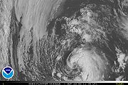
Tropical Storm Laura was a short lived tropical cyclone
that developed over the north-central Atlantic Ocean
in late September during the 2008 Atlantic hurricane season
. The 12th named storm of the season, Laura formed out of a large extratropical
area of low pressure
located about 1015 miles (1635 km) west of the Azores
on September 29. Laura slowly developed tropical characteristics throughout the day as it moved over warmer waters. On the afternoon of September 30, Laura had acquired enough tropical characteristics to be designated a Tropical Storm. Shortly after being declared tropical, Laura began to undergo an extratropical
transition, which did not fully take place until the morning of October 1. Laura degenerated into a post-tropical cyclone later that morning, and the final advisory by the National Hurricane Center
was issued. The remnants of Laura contributed to heavy rainfall and power outages in the British Isles
, the Netherlands
, and Norway
on October 5 to 8.
area of low pressure
developed along a quasi-stationary frontal system
a few hundred miles west of the Azores
. The low intensified into the equivalent of a Category 1 hurricane with winds of 80 mph (130 km/h) at 12:00 UTC
on September 27. Over the following days, the low began to lose its frontal features and began to transition into a subtropical cyclone
as it traveled in a general westward direction. By September 29, the low had developed sufficient convection
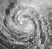
and was declared Subtropical Storm Laura. Upon being upgraded, cold cloud tops began to wrap around the center of Laura and consolidate near the center of circulation. The convection organized around the center quickly and a satellite pass over the storm revealed that it could be intensifying. A later satellite pass disregarded the possibility of intensification as the intensity was confirmed to be at 60 mph (95 km/h). The overall structure of Laura remained subtropical but there were indications that it was acquiring tropical characteristics.
During the afternoon, satellites revealed that Laura had developed a deep warm core, a characteristic of a tropical cyclone, but the wind field remained subtropical in nature. By the nighttime hours, the radius of the strongest winds contracted to 80 mi (130 km), much smaller than what is typical of a subtropical cyclone. However, Laura was still under the influence of an upper-level low and cloud tops remained shallow. However, the cloud tops became colder overnight and Laura was on the verge of becoming a tropical cyclone by the morning of September 30, but strong interaction with the upper-level low meant it was still subtropical. Despite moving over colder waters, a water vapor satellite image determined that Laura had separated itself from the upper-level low, signifying it had developed into a tropical cyclone. Laura was re-classified as a tropical storm at a relatively high latitude
, 40.6°N. Not long after being declared tropical, early signs of an extratropical transition appeared. Cold air began to enter the storm on the west side and forecast models showed Laura becoming extratropical the next morning and non-tropical later the next day.
 Overnight, convection associated with Laura began to diminish and lose tropical characteristics, but still retained its status. Early on October 1, the extratropical
transition was fully apparent. Laura remained tropical but the cloud pattern was becoming frontal and there was little convection around the center of the system. With minimal shower and thunderstorm activity remaining around the center of Laura, the storm degenerated into a remnant-low pressure area
on October 1 while still producing tropical storm-force winds. The next day, the remnant system transitioned into an extratropical cyclone and began to re-intensify as it rapidly tracked towards the north. Early on October 3, the system slowed down as it turned towards the east and strengthened into a hurricane-force cyclone with winds of 75 mph (120 km/h). After accelerating towards the east, another large extratropical cyclone absorbed the remnants of Laura while located several hundred miles west of the British Isles
on October 4.
 As a tropical cyclone, Laura never approached land, and no damages or fatalities occurred. Since the storm remained over open waters for most of its life, several ships and oil platforms recorded tropical storm-force winds. The highest recorded winds were at an oil platform with the call sign VEP717 at 03:00 UTC on October 1. Winds were recorded up to 47 knots (54 mph; 87 km/h). Despite the lack of impact, the storm's remnants were caught in an upper-level jet stream
, and steered towards Europe
. There, they contributed to heavy rainfall across portions of Britain
on October 5, causing localized accumulation of flood waters. As a result, Glebe Road near Windermere
, England
was closed in both directions, and along the A65 road
between Old Hutton and Kirkby Lonsdale
, previously saturated soil, combined with overwhelmed storm drains resulted in localized flooding. Traffic on the M6 Motorway
was slowed due to poor driving conditions. One person had to be rescued from her car after driving into a flooded street. The UK Environment Agency
issued 76 flood watches and 21 severe flood warnings as a result of the rainfall.
On October 8, the remnants of Laura reached the Netherlands
. At the time, its rain bands began interacting with a cold front
associated with a well-developed low west of Norway
, dropping up to 113 mm (4.4 in) of precipitation in the northwestern Netherlands. Consequently, streets and homes in the village of Hippolytushoef
were reportedly inundated. The large amounts of precipitation broke the daily and monthly rainfall records for October, which were previously set in 2006. Gradually passing through Norway, the remnants of the storm caused significant damage to electric utilities
. As a result, more than 10,000 people lost power in southern parts of the country.
Tropical cyclone
A tropical cyclone is a storm system characterized by a large low-pressure center and numerous thunderstorms that produce strong winds and heavy rain. Tropical cyclones strengthen when water evaporated from the ocean is released as the saturated air rises, resulting in condensation of water vapor...
that developed over the north-central Atlantic Ocean
Atlantic Ocean
The Atlantic Ocean is the second-largest of the world's oceanic divisions. With a total area of about , it covers approximately 20% of the Earth's surface and about 26% of its water surface area...
in late September during the 2008 Atlantic hurricane season
2008 Atlantic hurricane season
The 2008 Atlantic hurricane season was a very active hurricane season with sixteen named storms formed, including eight that became hurricanes and five that became major hurricanes. The season officially started on June 1 and ended on November 30. These dates conventionally delimit the period of...
. The 12th named storm of the season, Laura formed out of a large extratropical
Extratropical cyclone
Extratropical cyclones, sometimes called mid-latitude cyclones or wave cyclones, are a group of cyclones defined as synoptic scale low pressure weather systems that occur in the middle latitudes of the Earth having neither tropical nor polar characteristics, and are connected with fronts and...
area of low pressure
Low pressure area
A low-pressure area, or "low", is a region where the atmospheric pressure at sea level is below that of surrounding locations. Low-pressure systems form under areas of wind divergence which occur in upper levels of the troposphere. The formation process of a low-pressure area is known as...
located about 1015 miles (1635 km) west of the Azores
Azores
The Archipelago of the Azores is composed of nine volcanic islands situated in the middle of the North Atlantic Ocean, and is located about west from Lisbon and about east from the east coast of North America. The islands, and their economic exclusion zone, form the Autonomous Region of the...
on September 29. Laura slowly developed tropical characteristics throughout the day as it moved over warmer waters. On the afternoon of September 30, Laura had acquired enough tropical characteristics to be designated a Tropical Storm. Shortly after being declared tropical, Laura began to undergo an extratropical
Extratropical cyclone
Extratropical cyclones, sometimes called mid-latitude cyclones or wave cyclones, are a group of cyclones defined as synoptic scale low pressure weather systems that occur in the middle latitudes of the Earth having neither tropical nor polar characteristics, and are connected with fronts and...
transition, which did not fully take place until the morning of October 1. Laura degenerated into a post-tropical cyclone later that morning, and the final advisory by the National Hurricane Center
National Hurricane Center
The National Hurricane Center , located at Florida International University in Miami, Florida, is the division of the National Weather Service responsible for tracking and predicting weather systems within the tropics between the Prime Meridian and the 140th meridian west poleward to the 30th...
was issued. The remnants of Laura contributed to heavy rainfall and power outages in the British Isles
British Isles
The British Isles are a group of islands off the northwest coast of continental Europe that include the islands of Great Britain and Ireland and over six thousand smaller isles. There are two sovereign states located on the islands: the United Kingdom of Great Britain and Northern Ireland and...
, the Netherlands
Netherlands
The Netherlands is a constituent country of the Kingdom of the Netherlands, located mainly in North-West Europe and with several islands in the Caribbean. Mainland Netherlands borders the North Sea to the north and west, Belgium to the south, and Germany to the east, and shares maritime borders...
, and Norway
Norway
Norway , officially the Kingdom of Norway, is a Nordic unitary constitutional monarchy whose territory comprises the western portion of the Scandinavian Peninsula, Jan Mayen, and the Arctic archipelago of Svalbard and Bouvet Island. Norway has a total area of and a population of about 4.9 million...
on October 5 to 8.
Meteorological history
On September 26, an extratropicalExtratropical cyclone
Extratropical cyclones, sometimes called mid-latitude cyclones or wave cyclones, are a group of cyclones defined as synoptic scale low pressure weather systems that occur in the middle latitudes of the Earth having neither tropical nor polar characteristics, and are connected with fronts and...
area of low pressure
Low pressure area
A low-pressure area, or "low", is a region where the atmospheric pressure at sea level is below that of surrounding locations. Low-pressure systems form under areas of wind divergence which occur in upper levels of the troposphere. The formation process of a low-pressure area is known as...
developed along a quasi-stationary frontal system
Weather front
A weather front is a boundary separating two masses of air of different densities, and is the principal cause of meteorological phenomena. In surface weather analyses, fronts are depicted using various colored lines and symbols, depending on the type of front...
a few hundred miles west of the Azores
Azores
The Archipelago of the Azores is composed of nine volcanic islands situated in the middle of the North Atlantic Ocean, and is located about west from Lisbon and about east from the east coast of North America. The islands, and their economic exclusion zone, form the Autonomous Region of the...
. The low intensified into the equivalent of a Category 1 hurricane with winds of 80 mph (130 km/h) at 12:00 UTC
Coordinated Universal Time
Coordinated Universal Time is the primary time standard by which the world regulates clocks and time. It is one of several closely related successors to Greenwich Mean Time. Computer servers, online services and other entities that rely on having a universally accepted time use UTC for that purpose...
on September 27. Over the following days, the low began to lose its frontal features and began to transition into a subtropical cyclone
Subtropical cyclone
A subtropical cyclone is a weather system that has some characteristics of a tropical and an extratropical cyclone. As early as the 1950s, meteorologists were unclear whether they should be characterized as tropical or extratropical cyclones. They were officially recognized by the National...
as it traveled in a general westward direction. By September 29, the low had developed sufficient convection
Atmospheric convection
Atmospheric convection is the result of a parcel-environment instability, or temperature difference, layer in the atmosphere. Different lapse rates within dry and moist air lead to instability. Mixing of air during the day which expands the height of the planetary boundary layer leads to...
and was declared Subtropical Storm Laura. Upon being upgraded, cold cloud tops began to wrap around the center of Laura and consolidate near the center of circulation. The convection organized around the center quickly and a satellite pass over the storm revealed that it could be intensifying. A later satellite pass disregarded the possibility of intensification as the intensity was confirmed to be at 60 mph (95 km/h). The overall structure of Laura remained subtropical but there were indications that it was acquiring tropical characteristics.
During the afternoon, satellites revealed that Laura had developed a deep warm core, a characteristic of a tropical cyclone, but the wind field remained subtropical in nature. By the nighttime hours, the radius of the strongest winds contracted to 80 mi (130 km), much smaller than what is typical of a subtropical cyclone. However, Laura was still under the influence of an upper-level low and cloud tops remained shallow. However, the cloud tops became colder overnight and Laura was on the verge of becoming a tropical cyclone by the morning of September 30, but strong interaction with the upper-level low meant it was still subtropical. Despite moving over colder waters, a water vapor satellite image determined that Laura had separated itself from the upper-level low, signifying it had developed into a tropical cyclone. Laura was re-classified as a tropical storm at a relatively high latitude
Latitude
In geography, the latitude of a location on the Earth is the angular distance of that location south or north of the Equator. The latitude is an angle, and is usually measured in degrees . The equator has a latitude of 0°, the North pole has a latitude of 90° north , and the South pole has a...
, 40.6°N. Not long after being declared tropical, early signs of an extratropical transition appeared. Cold air began to enter the storm on the west side and forecast models showed Laura becoming extratropical the next morning and non-tropical later the next day.
Extratropical cyclone
Extratropical cyclones, sometimes called mid-latitude cyclones or wave cyclones, are a group of cyclones defined as synoptic scale low pressure weather systems that occur in the middle latitudes of the Earth having neither tropical nor polar characteristics, and are connected with fronts and...
transition was fully apparent. Laura remained tropical but the cloud pattern was becoming frontal and there was little convection around the center of the system. With minimal shower and thunderstorm activity remaining around the center of Laura, the storm degenerated into a remnant-low pressure area
Low pressure area
A low-pressure area, or "low", is a region where the atmospheric pressure at sea level is below that of surrounding locations. Low-pressure systems form under areas of wind divergence which occur in upper levels of the troposphere. The formation process of a low-pressure area is known as...
on October 1 while still producing tropical storm-force winds. The next day, the remnant system transitioned into an extratropical cyclone and began to re-intensify as it rapidly tracked towards the north. Early on October 3, the system slowed down as it turned towards the east and strengthened into a hurricane-force cyclone with winds of 75 mph (120 km/h). After accelerating towards the east, another large extratropical cyclone absorbed the remnants of Laura while located several hundred miles west of the British Isles
British Isles
The British Isles are a group of islands off the northwest coast of continental Europe that include the islands of Great Britain and Ireland and over six thousand smaller isles. There are two sovereign states located on the islands: the United Kingdom of Great Britain and Northern Ireland and...
on October 4.
Impact
Jet stream
Jet streams are fast flowing, narrow air currents found in the atmospheres of some planets, including Earth. The main jet streams are located near the tropopause, the transition between the troposphere and the stratosphere . The major jet streams on Earth are westerly winds...
, and steered towards Europe
Europe
Europe is, by convention, one of the world's seven continents. Comprising the westernmost peninsula of Eurasia, Europe is generally 'divided' from Asia to its east by the watershed divides of the Ural and Caucasus Mountains, the Ural River, the Caspian and Black Seas, and the waterways connecting...
. There, they contributed to heavy rainfall across portions of Britain
Great Britain
Great Britain or Britain is an island situated to the northwest of Continental Europe. It is the ninth largest island in the world, and the largest European island, as well as the largest of the British Isles...
on October 5, causing localized accumulation of flood waters. As a result, Glebe Road near Windermere
Windermere
Windermere is the largest natural lake of England. It is also a name used in a number of places, including:-Australia:* Lake Windermere , a reservoir, Australian Capital Territory * Lake Windermere...
, England
England
England is a country that is part of the United Kingdom. It shares land borders with Scotland to the north and Wales to the west; the Irish Sea is to the north west, the Celtic Sea to the south west, with the North Sea to the east and the English Channel to the south separating it from continental...
was closed in both directions, and along the A65 road
A65 road
The A65 is a major road in England. It runs north west from Leeds in Yorkshire via Kirkstall, Horsforth, Yeadon, Guiseley, Ilkley and Skipton, passes west of Settle, then continues through Ingleton and Kirkby Lonsdale before terminating at Kendal in Cumbria....
between Old Hutton and Kirkby Lonsdale
Kirkby Lonsdale
Kirkby Lonsdale is a small town and civil parish in the South Lakeland district of Cumbria, England, on the River Lune. Historically within Westmorland, it is situated south east of Kendal along the A65. The parish had a population of 1,771 recorded in the 2001 census.Notable buildings include St...
, previously saturated soil, combined with overwhelmed storm drains resulted in localized flooding. Traffic on the M6 Motorway
M6 motorway
The M6 motorway runs from junction 19 of the M1 at the Catthorpe Interchange, near Rugby via Birmingham then heads north, passing Stoke-on-Trent, Manchester, Preston, Carlisle and terminating at the Gretna junction . Here, just short of the Scottish border it becomes the A74 which continues to...
was slowed due to poor driving conditions. One person had to be rescued from her car after driving into a flooded street. The UK Environment Agency
Environment Agency
The Environment Agency is a British non-departmental public body of the Department for Environment, Food and Rural Affairs and an Assembly Government Sponsored Body of the Welsh Assembly Government that serves England and Wales.-Purpose:...
issued 76 flood watches and 21 severe flood warnings as a result of the rainfall.
On October 8, the remnants of Laura reached the Netherlands
Netherlands
The Netherlands is a constituent country of the Kingdom of the Netherlands, located mainly in North-West Europe and with several islands in the Caribbean. Mainland Netherlands borders the North Sea to the north and west, Belgium to the south, and Germany to the east, and shares maritime borders...
. At the time, its rain bands began interacting with a cold front
Cold front
A cold front is defined as the leading edge of a cooler mass of air, replacing a warmer mass of air.-Development of cold front:The cooler and denser air wedges under the less-dense warmer air, lifting it...
associated with a well-developed low west of Norway
Norway
Norway , officially the Kingdom of Norway, is a Nordic unitary constitutional monarchy whose territory comprises the western portion of the Scandinavian Peninsula, Jan Mayen, and the Arctic archipelago of Svalbard and Bouvet Island. Norway has a total area of and a population of about 4.9 million...
, dropping up to 113 mm (4.4 in) of precipitation in the northwestern Netherlands. Consequently, streets and homes in the village of Hippolytushoef
Hippolytushoef
Hippolytushoef is a town in the Dutch province of North Holland. It is the main town of the municipality of Wieringen, and lies about 14 km east of Den Helder....
were reportedly inundated. The large amounts of precipitation broke the daily and monthly rainfall records for October, which were previously set in 2006. Gradually passing through Norway, the remnants of the storm caused significant damage to electric utilities
Electric utility
An electric utility is a company that engages in the generation, transmission, and distribution of electricity for sale generally in a regulated market. The electrical utility industry is a major provider of energy in most countries. It is indispensable to factories, commercial establishments,...
. As a result, more than 10,000 people lost power in southern parts of the country.
See also
- Other storms of the same name
- Timeline of the 2008 Atlantic hurricane seasonTimeline of the 2008 Atlantic hurricane seasonThe 2008 Atlantic hurricane season was a well above-average year in which sixteen named storms formed, making it the fourth most active season ever recorded. An average season has eleven tropical storms, six hurricanes and two major hurricanes...
External links
- The NHC's Advisory Archive for Laura
- The NHC's Tropical Cyclone Report on Laura