
Transportation in West Virginia
Encyclopedia
Interstate highways
|
Interstate 73 Interstate 73 is a main route of the Interstate Highway System, currently located entirely within the U.S. state of North Carolina. It is part of a longer planned corridor, defined by various Federal laws to run from Myrtle Beach, South Carolina, to Grayling, Michigan, but only the part south of... (proposed) Interstate 77 Interstate 77 is an Interstate Highway in the eastern United States. It traverses diverse terrain, from the mountainous state of West Virginia to the rolling farmlands of North Carolina and Ohio. It largely supplants the old U.S... West Virginia Turnpike The West Virginia Turnpike is a toll road in the US state of West Virginia. It is also signed as Interstate 77 for its entire length as well as Interstate 64 from Charleston to just south of Beckley. From Beckley, the road extends south to Princeton... Interstate 79 Interstate 79 is an Interstate Highway in the eastern United States, designated from Interstate 77 in Charleston, West Virginia to Pennsylvania Route 5 and Pennsylvania Route 290 in Erie, Pennsylvania... Interstate 81 Interstate 81 is an Interstate Highway in the eastern part of the United States. Its southern terminus is at Interstate 40 in Dandridge, Tennessee; its northern terminus is on Wellesley Island at the Canadian border, where the Thousand Islands Bridge connects it to Highway 401, the main freeway... |
U.S. Highways
|
U.S. Route 21 U.S. Route 21 is a north–south United States highway of , from Hunting Island State Park, South Carolina to Wytheville, Virginia.-South Carolina:... U.S. Route 121 U.S. Route 121 is a proposed highway designated as the Coalfields Expressway, a four lane highway stretching from Beckley, West Virginia to Pound, Virginia, approximately in length. It is designed to connect Interstate 77/Interstate 64 in West Virginia near Beckley to U.S. Route 23 in Wise County,... U.S. Route 22 U.S. Route 22 is a west–east route and is one of the original United States highways of 1926, running from Cincinnati, Ohio, at US 27, US 42, US 127, and US 52 to Newark, New Jersey, at U.S. Route 1/9 near the Newark Liberty International Airport.US 22 also carries the names of the William... U.S. Route 522 U.S. Route 522 is a spur route of U.S. Route 22 in the eastern United States. The southern terminus of the route is at U.S. Route 60 in Powhatan, Virginia. The northern terminus is at U.S. Route 11 and U.S. Route 15 in Selinsgrove, Pennsylvania. US 522 passes through the states of Virginia, West... U.S. Route 30 U.S. Route 30 is an east–west main route of the system of United States Numbered Highways, with the highway traveling across the northern tier of the country. It is the third longest U.S. route, after U.S. Route 20 and U.S. Route 6. The western end of the highway is at Astoria, Oregon; the... |
U.S. Route 33 U.S. Route 33 is a United States federal highway that runs northwest-southeast for 709 miles from northern Indiana to Richmond, Virginia, passing through Ohio and West Virginia en route. Although most odd-numbered U.S... U.S. Route 35 U.S. Route 35 is a north–south United States highway that runs northwest-southeast for approximately from northern Indiana to the western suburbs of Charleston, West Virginia. The highway's northern terminus is in Michigan City, Indiana, at U.S. Route 20. Its southern terminus is in Scott... U.S. Route 40 U.S. Route 40 is an east–west United States highway. As with most routes whose numbers end in a zero, U.S. 40 once traversed the entire United States. It is one of the original 1920s U.S. Highways, and its first termini were San Francisco, California, and Atlantic City, New Jersey... U.S. Route 340 U.S. Route 340 is a spur of US 40. It currently runs for from Greenville, Virginia at US 11 to Frederick, Maryland at US 40. Between those two states, US 340 also passes briefly through West Virginia. In Virginia and West Virginia, it is signed north–south... U.S. Route 48 U.S. Route 48 , or Corridor H, is part of the Appalachian Development Highway System. It is an east–west United States highway that runs from northern Virginia to central West Virginia.- West Virginia :... |
U.S. Route 50 U.S. Route 50 is a major east–west route of the U.S. Highway system, stretching just over from Ocean City, Maryland on the Atlantic Ocean to West Sacramento, California. Until 1972, when it was replaced by Interstate Highways west of the Sacramento area, it extended to San Francisco, near... U.S. Route 250 U.S. Route 250 is a route of the United States Numbered Highway System, and is a spur of U.S. Route 50. It currently runs for from Sandusky, Ohio to Richmond, Virginia. It passes through the states of Virginia, West Virginia, and Ohio. It goes through the cities of Richmond, Virginia,... U.S. Route 52 U.S. Route 52 is a United States highway that runs across the northern, eastern and southeastern regions of the United States. Contrary to most other even-numbered U.S... U.S. Route 60 U.S. Route 60 is an east–west United States highway, running from the Atlantic Ocean on the east coast in Virginia to western Arizona. Despite the final "0" in its number, indicating a transcontinental designation, the 1926 route formerly ended in Springfield, Missouri, at its intersection... Midland Trail For the trail's section in West Virginia see: The Midland Trail in West Virginia.The Midland Trail, also called the Roosevelt Midland Trail, was a national auto trail spanning the United States from Washington, D.C... |
U.S. Route 460 U.S. Route 460 is a spur of U.S. Route 60. It currently runs for 655 miles from Norfolk, Virginia at U.S. Route 60 at Ocean View to Frankfort, Kentucky at U.S. Route 60. It passes through the states of Virginia, West Virginia, and Kentucky... |
West Virginia State Highways
Airports
- Beckley Raleigh County Memorial AirportBeckley Raleigh County Memorial Airport- External links :* at West Virginia Airport Directory...
- Eastern West Virginia Regional AirportEastern WV Regional AirportEastern WV Regional Airport , also known as Shepherd Field, is a joint civil-military public airport located four miles south of the central business district of Martinsburg, a city in Berkeley County, West Virginia, USA....
- Elkins-Randolph County Airport
- Greater Cumberland Regional AirportGreater Cumberland Regional AirportGreater Cumberland Regional Airport is a public airport located in the town of Wiley Ford in Mineral County, West Virginia. It is two miles south of the larger city of Cumberland in Allegany County, Maryland...
- Greenbrier Valley AirportGreenbrier Valley AirportGreenbrier Valley Airport is a public use airport located three nautical miles north of the central business district of Lewisburg, a city in Greenbrier County, West Virginia, United States. It is owned by the Greenbrier County Airport Authority....
- Harrison/Marion Regional AirportHarrison/Marion Regional AirportNorth Central West Virginia Airport is a joint-use public and military airport in Harrison County, West Virginia, United States. The airport is one nautical mile northeast of the central business district of Clarksburg, West Virginia, in Bridgeport, West Virginia...
- Mercer County Airport
- Mid-Ohio Valley Regional AirportMid-Ohio Valley Regional AirportMid-Ohio Valley Regional Airport , also known as Wood County Airport or Gill Robb Wilson Field, is a public airport located six miles northeast of the central business district of Parkersburg, a city in Wood County, West Virginia, USA...
- Morgantown Municipal AirportMorgantown Municipal AirportMorgantown Municipal Airport , also known as Walter L. Bill Hart Field, is a public-use airport located three nautical miles east of the central business district of Morgantown, in Monongalia County, West Virginia, United States. The airport is owned by the City of Morgantown...
- Potomac Airpark
- Tri-State AirportTri-State AirportTri-State Airport , also known as Milton J. Ferguson Field, is a public-use airport in Wayne County, West Virginia, United States. The airport is located three nautical miles south of the central business district of Huntington, West Virginia, near the cities of Ceredo and Kenova...
- Wheeling Ohio County AirportWheeling Ohio County AirportWheeling Ohio County Airport is a public airport serving the city of Wheeling and Ohio County in the U.S. state of West Virginia. It is located eight miles northeast of the central business district of Wheeling and the northern portion of the airport situated in Brooke County, southeast of Short...
- Yeager AirportYeager AirportYeager Airport is a public-use airport located three nautical miles east of the central business district of Charleston, a city in Kanawha County, West Virginia, United States. It is owned by the Central West Virginia Regional Airport Authority...
Railroads
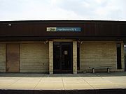
Today, West Virginia is serviced by two Amtrak
Amtrak
The National Railroad Passenger Corporation, doing business as Amtrak , is a government-owned corporation that was organized on May 1, 1971, to provide intercity passenger train service in the United States. "Amtrak" is a portmanteau of the words "America" and "track". It is headquartered at Union...
lines: one that cuts through the southern portion of the state, including stops in Huntington
Huntington, West Virginia
Huntington is a city in Cabell and Wayne counties in the U.S. state of West Virginia, along the Ohio River. Most of the city is in Cabell County, for which it is the county seat. A small portion of the city, mainly the neighborhood of Westmoreland, is in Wayne County. Its population was 49,138 at...
and Charleston
Charleston, West Virginia
Charleston is the capital and largest city of the U.S. state of West Virginia. It is located at the confluence of the Elk and Kanawha Rivers in Kanawha County. As of the 2010 census, it has a population of 51,400, and its metropolitan area 304,214. It is the county seat of Kanawha County.Early...
, and one that cuts through the state's Eastern Panhandle
Eastern Panhandle of West Virginia
The Eastern Panhandle of West Virginia is a narrow stretch of territory in the northeast of the state, bordering Maryland and Virginia, United States. The Eastern Panhandle Board of Realtors and other local civic organizations consider only the three Easternmost counties, Jefferson, Berkeley and...
, including stops in Martinsburg
Martinsburg, West Virginia
Martinsburg is a city in the Eastern Panhandle region of West Virginia, United States. The city's population was 14,972 at the 2000 census; according to a 2009 Census Bureau estimate, Martinsburg's population was 17,117, making it the largest city in the Eastern Panhandle and the eighth largest...
and Harpers Ferry
Harpers Ferry, West Virginia
Harpers Ferry is a historic town in Jefferson County, West Virginia, United States. In many books the town is called "Harper's Ferry" with an apostrophe....
. The Eastern Panhandle is also serviced during the week by MARC's
MARC Train
MARC , known prior to 1984 as Maryland Rail Commuter Service, is a regional rail system comprising three lines in the Baltimore-Washington Metropolitan Area. MARC is administered by the Maryland Transit Administration , a Maryland Department of Transportation agency, and is operated under contract...
Brunswick commuter rail line
Brunswick Line
The Brunswick Line is a MARC commuter rail line consisting of a main line running from Washington D.C. to Martinsburg, West Virginia and a branch line from just south of Point-of-Rocks station to Frederick, Maryland. The service is operated under contract by CSX Transportation, but is administered...
, which terminates in Martinsburg. Commercial railroads still operate in the state, mainly hauling coal to inland ports such as Huntington (the nation's busiest) and Pittsburgh
Pittsburgh, Pennsylvania
Pittsburgh is the second-largest city in the US Commonwealth of Pennsylvania and the county seat of Allegheny County. Regionally, it anchors the largest urban area of Appalachia and the Ohio River Valley, and nationally, it is the 22nd-largest urban area in the United States...
.
Bridges and tunnels
As a mountainous state, bridges and tunnels play an important role in transportation in West Virginia. Notable bridges and tunnels include:- New River Gorge BridgeNew River Gorge BridgeThe New River Gorge Bridge is a steel arch bridge long over the New River Gorge near Fayetteville, West Virginia, in the Appalachian Mountains of the eastern United States. With an arch long, the New River Gorge Bridge was for many years the world's longest arch bridge; it is now the third...
-- near Fayetteville, WVFayetteville, West VirginiaFayetteville is a town in and the county seat of Fayette County, West Virginia, United States. The population was 2,754 at the 2000 census.Fayetteville was listed as one of the 2006 "Top 10 Coolest Small Towns in America" by Budget Travel Magazine .... - Silver BridgeSilver BridgeThe Silver Bridge collapsed in 1967, killing 46 people. The terms Silver Bridge or Silverbridge may also refer to:* Silver Memorial Bridge, the replacement for the above bridge, opened in 1969....
-- Point Pleasant, WVPoint Pleasant, West VirginiaPoint Pleasant is a city in Mason County, West Virginia, United States, at the confluence of the Ohio and Kanawha rivers. The population was 4,637 at the 2000 census... - Silver Memorial BridgeSilver Memorial BridgeThe Silver Memorial Bridge is a cantilever bridge which spans the Ohio River between Gallipolis, Ohio and Henderson, West Virginia. The bridge was completed in 1969, shortly after the Silver Bridge disaster, although it is located about 1 mile downstream of the original...
-- Henderson, WVHenderson, West VirginiaHenderson is a town in Mason County, West Virginia, United States, at the confluence of the Ohio and Kanawha Rivers. The population was 325 at the 2000 census. It is part of the Point Pleasant, WV–OH Micropolitan Statistical Area...
to Gallipolis, OHGallipolis, OhioAs of the census of 2000, there were 4,180 people, 1,847 households, and 1,004 families residing in the village. The population density was 1,156.2 people per square mile . There were 2,056 housing units at an average density of 568.7 per square mile... - Wheeling Suspension BridgeWheeling Suspension BridgeThe Wheeling Suspension Bridge is a suspension bridge spanning the main channel of the Ohio River at Wheeling, West Virginia. It was the largest suspension bridge in the world from 1849 until the Queenston-Lewiston Bridge was opened in 1851. It was designed by Charles Ellet Jr., who also worked...
-- Wheeling, WVWheeling, West VirginiaWheeling is a city in Ohio and Marshall counties in the U.S. state of West Virginia; it is the county seat of Ohio County. Wheeling is the principal city of the Wheeling Metropolitan Statistical Area... - East River Mountain TunnelEast River Mountain TunnelThe East River Mountain Tunnel is a vehicular tunnel that carries Interstate 77 and U.S. Route 52 through East River Mountain between the communities of Bluefield, West Virginia, and Rocky Gap, Virginia.-History:...
-- near Bluefield, WVBluefield, West VirginiaBluefield is a city in Mercer County, West Virginia, United States. The population was 10,447 at the 2010 census. It is also the core city of the Bluefield WV-VA micropolitan area which has a population of 107,342.-Geography & Climate:...
to near Rocky Gap, VARocky Gap, VirginiaRocky Gap is an unincorporated community that is located in Bland County in the U.S. state of Virginia. Rocky Gap's center sits at a high elevation of around 2,887 ft. In the year of 2009, there was an estimate that there were a total of 75 people living in Rocky Gap. Rocky Gap has one zip code... - Fort Henry BridgeFort Henry BridgeThe Fort Henry Bridge is a crossing of the Ohio River main channel in Wheeling, West Virginia. The tied-arch bridge carries two lanes in each direction of Interstate 70 , U.S. Route 40 , and US 250. The bridge opened after four years of construction work on September 8, 1955, costing $6.8...
-- Wheeling, WVWheeling, West VirginiaWheeling is a city in Ohio and Marshall counties in the U.S. state of West Virginia; it is the county seat of Ohio County. Wheeling is the principal city of the Wheeling Metropolitan Statistical Area... - Veterans Memorial BridgeVeterans Memorial Bridge (Steubenville, Ohio)The Veterans Memorial Bridge, also known as the New Steubenville Bridge, is a cable-stayed bridge which carries U.S. Route 22 across the Ohio River between Steubenville, Ohio and Weirton, West Virginia. Planning for the bridge began in 1961 in Ohio and in 1964 in West Virginia, and the bridge's...
-- Weirton, WVWeirton, West VirginiaWeirton is a city located in the Northern Panhandle of West Virginia, United States. Most of the city is in Hancock County, with the remainder in Brooke County. As of the 2000 census, the city population was 20,411...
to Steubenville, OHSteubenville, OhioSteubenville is a city located along the Ohio River in Jefferson County, Ohio on the Ohio-West Virginia border in the United States. It is the political county seat of Jefferson County. It is also a principal city of the Weirton–Steubenville, WV-OH Metropolitan Statistical Area...
Rivers
Rivers with commercial barge traffic and docks in West Virginia include:- OhioOhio RiverThe Ohio River is the largest tributary, by volume, of the Mississippi River. At the confluence, the Ohio is even bigger than the Mississippi and, thus, is hydrologically the main stream of the whole river system, including the Allegheny River further upstream...
- KanawhaKanawha RiverThe Kanawha River is a tributary of the Ohio River, approximately 97 mi long, in the U.S. state of West Virginia. The largest inland waterway in West Virginia, it has formed a significant industrial region of the state since the middle of the 19th century.It is formed at the town of Gauley...
(a tributary of the Ohio) - MonongahelaMonongahela RiverThe Monongahela River is a river on the Allegheny Plateau in north-central West Virginia and southwestern Pennsylvania in the United States...
(the MonMonongahela RiverThe Monongahela River is a river on the Allegheny Plateau in north-central West Virginia and southwestern Pennsylvania in the United States...
and the Allegheny RiverAllegheny RiverThe Allegheny River is a principal tributary of the Ohio River; it is located in the Eastern United States. The Allegheny River joins with the Monongahela River to form the Ohio River at the "Point" of Point State Park in Downtown Pittsburgh, Pennsylvania...
s meet to form the OhioOhio RiverThe Ohio River is the largest tributary, by volume, of the Mississippi River. At the confluence, the Ohio is even bigger than the Mississippi and, thus, is hydrologically the main stream of the whole river system, including the Allegheny River further upstream...
in Pittsburgh, PennsylvaniaPittsburgh, PennsylvaniaPittsburgh is the second-largest city in the US Commonwealth of Pennsylvania and the county seat of Allegheny County. Regionally, it anchors the largest urban area of Appalachia and the Ohio River Valley, and nationally, it is the 22nd-largest urban area in the United States...
. - Little KanawhaLittle Kanawha RiverThe Little Kanawha River is a tributary of the Ohio River, 169 mi long, in western West Virginia in the United States. Via the Ohio, it is part of the watershed of the Mississippi River, draining an area of 2,320 mi² on the unglaciated portion of the Allegheny Plateau...
(a tributary of the Ohio) - Big SandyBig Sandy River (Ohio River)The Big Sandy River is a tributary of the Ohio River, approximately long, in western West Virginia and northeastern Kentucky in the United States. The river forms part of the boundary between the two states along its entire course...
(a tributary of the Ohio) - ElkElk River (West Virginia)The Elk River is a tributary of the Kanawha River, long, in central West Virginia in the United States. Via the Kanawha and Ohio Rivers, it is part of the watershed of the Mississippi River.-Course:...
(a tributary of the Kanawha) - PocatalicoPocatalico RiverThe Pocatalico River is a tributary of the Kanawha River, about 75 mi long, in west-central West Virginia in the United States. Via the Kanawha and Ohio Rivers, it is part of the Mississippi River watershed....
(a tributary of the Kanawha) - Mill CreekMill Creek (western West Virginia)Mill Creek is a tributary of the Ohio River, long, in western West Virginia in the United States. Via the Ohio, it is part of the watershed of the Mississippi River, draining an area of on the unglaciated portion of the Allegheny Plateau...
(a tributary of the Ohio)
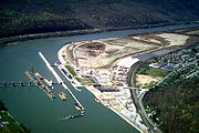
Navigation Lock and Dams in West Virginia
- On the OhioOhio RiverThe Ohio River is the largest tributary, by volume, of the Mississippi River. At the confluence, the Ohio is even bigger than the Mississippi and, thus, is hydrologically the main stream of the whole river system, including the Allegheny River further upstream...
- New Cumberland Locks and Dam
- Pike Island Locks and Dam
- Hannibal Locks and Dam
- Willow Island Locks and Dam
- Belleville Locks and Dam
- Racine Locks and Dam
- Robert C. Byrd Locks and Dam
- On the KanawhaKanawha RiverThe Kanawha River is a tributary of the Ohio River, approximately 97 mi long, in the U.S. state of West Virginia. The largest inland waterway in West Virginia, it has formed a significant industrial region of the state since the middle of the 19th century.It is formed at the town of Gauley...
- London Lock and Dam
- Marmet Lock and Dam
- Winfield Lock and Dam
- On the MonogahelaMonongahela RiverThe Monongahela River is a river on the Allegheny Plateau in north-central West Virginia and southwestern Pennsylvania in the United States...
- Morgantown Lock and Dam
- Hildebrand Lock and Dam
- Opekiska Lock and Dam