

U.S. Route 121
Encyclopedia

Highway
A highway is any public road. In American English, the term is common and almost always designates major roads. In British English, the term designates any road open to the public. Any interconnected set of highways can be variously referred to as a "highway system", a "highway network", or a...
designated as the Coalfields Expressway, a four lane highway stretching from Beckley, West Virginia
Beckley, West Virginia
Beckley is a city in Raleigh County, West Virginia, United States, which was founded on April 4, 1838. The 2008 population was estimated to be 16,832 by the U.S. Census Bureau. Early in its history, the town was known as Beckleyville and Raleigh Court House...
to Pound, Virginia
Pound, Virginia
Pound is a town in Wise County, Virginia, United States. The population was 1,089 as recorded in the 2000 census.-Geography:Pound is located at ....
, approximately 62 miles (99.8 km) in length. It is designed to connect Interstate 77
Interstate 77
Interstate 77 is an Interstate Highway in the eastern United States. It traverses diverse terrain, from the mountainous state of West Virginia to the rolling farmlands of North Carolina and Ohio. It largely supplants the old U.S...
/Interstate 64
Interstate 64
Interstate 64 is an Interstate Highway in the Midwestern and Southeastern United States. Its western terminus is at I-70, U.S. 40, and U.S. 61 in Wentzville, Missouri. Its eastern terminus is at an interchange with I-264 and I-664 at Bowers Hill in Chesapeake, Virginia. As I-64 is concurrent with...
in West Virginia
West Virginia
West Virginia is a state in the Appalachian and Southeastern regions of the United States, bordered by Virginia to the southeast, Kentucky to the southwest, Ohio to the northwest, Pennsylvania to the northeast and Maryland to the east...
near Beckley
Beckley, West Virginia
Beckley is a city in Raleigh County, West Virginia, United States, which was founded on April 4, 1838. The 2008 population was estimated to be 16,832 by the U.S. Census Bureau. Early in its history, the town was known as Beckleyville and Raleigh Court House...
to U.S. Route 23 in Wise County, Virginia
Wise County, Virginia
Wise County is a county located in the U.S. state of Virginia. In 1856, the county was formed from land taken from Lee, Scott, and Russell Counties. It was named after Henry A. Wise, who was the Governor of Virginia at the time. As of 2010, the population was 41,452, making it the largest...
at Pound
Pound, Virginia
Pound is a town in Wise County, Virginia, United States. The population was 1,089 as recorded in the 2000 census.-Geography:Pound is located at ....
.
While U.S. 121 will not connect directly to U.S. Route 21
U.S. Route 21
U.S. Route 21 is a north–south United States highway of , from Hunting Island State Park, South Carolina to Wytheville, Virginia.-South Carolina:...
, it will intersect at the latter road's original alignment, now a part of I-77.
History
Interstate 64
Interstate 64 is an Interstate Highway in the Midwestern and Southeastern United States. Its western terminus is at I-70, U.S. 40, and U.S. 61 in Wentzville, Missouri. Its eastern terminus is at an interchange with I-264 and I-664 at Bowers Hill in Chesapeake, Virginia. As I-64 is concurrent with...
/Interstate 77
Interstate 77
Interstate 77 is an Interstate Highway in the eastern United States. It traverses diverse terrain, from the mountainous state of West Virginia to the rolling farmlands of North Carolina and Ohio. It largely supplants the old U.S...
interchange and travel southwest through depressed areas of West Virginia
West Virginia
West Virginia is a state in the Appalachian and Southeastern regions of the United States, bordered by Virginia to the southeast, Kentucky to the southwest, Ohio to the northwest, Pennsylvania to the northeast and Maryland to the east...
to U.S. Route 23 in Wise County, Virginia
Wise County, Virginia
Wise County is a county located in the U.S. state of Virginia. In 1856, the county was formed from land taken from Lee, Scott, and Russell Counties. It was named after Henry A. Wise, who was the Governor of Virginia at the time. As of 2010, the population was 41,452, making it the largest...
at Pound
Pound, Virginia
Pound is a town in Wise County, Virginia, United States. The population was 1,089 as recorded in the 2000 census.-Geography:Pound is located at ....
. The roadways US 121 will replace are deficient in the fact that the existing roadways have limited passing opportunities, steep grades, and low design speeds. The expressway will generally follow West Virginia Route 16 through Raleigh
Raleigh County, West Virginia
As of the census of 2000, there were 79,220 people, 31,793 households, and 22,096 families residing in the county. The population density was 130 people per square mile . There were 35,678 housing units at an average density of 59 per square mile...
and Wyoming Counties
Wyoming County, West Virginia
Wyoming County is a county located in the U.S. state of West Virginia. As of the 2010 census, the population was 23,796. Its county seat is Pineville. Wyoming County was created in 1850 from Logan County and named for the Delaware Indian word meaning "large plains."-Geography:According to the U.S...
, West Virginia Route 83 in McDowell County
McDowell County, West Virginia
McDowell County is a county in the U.S. state of West Virginia. The land that became McDowell was originally part of Tazewell County, Virginia. As of the 2010 census, the population was 22,113. Its county seat is Welch. McDowell county is the southern-most county in the state, geographically...
, and State Route 83
State Route 83 (Virginia)
Virginia State Route 83 is a primary state highway in the U.S. state of Virginia. The state highway runs from U.S. Route 23 Business in Pound east to the West Virginia state line in Paynesville, where the highway continues as West Virginia Route 83...
in Buchanan County, Virginia
Buchanan County, Virginia
As of the census of 2000, there were 26,978 people, 10,464 households, and 7,900 families residing in the county. The population density was 54 people per square mile . There were 11,887 housing units at an average density of 24 per square mile...
to U.S. 23 in Pound.
West Virginia
Construction started in 1999 with a three-level diamond interchange near WelchWelch, West Virginia
Welch is a city located in McDowell County in the U.S. state of West Virginia. The population was 2,406 at the 2010 census. Incorporated as a city in 1893, it is the county seat of McDowell County.-History:...
in western West Virginia. This will facilate traffic going between the King Coal Highway/Interstate 73
Interstate 73
Interstate 73 is a main route of the Interstate Highway System, currently located entirely within the U.S. state of North Carolina. It is part of a longer planned corridor, defined by various Federal laws to run from Myrtle Beach, South Carolina, to Grayling, Michigan, but only the part south of...
/Interstate 74
Interstate 74
Interstate 74 is an Interstate Highway in the Midwestern and Southeastern United States. Its western end is at an intersection with Interstate 80 in Davenport, Iowa; the eastern end of its Midwest segment is at an intersection with Interstate 75 in Cincinnati, Ohio...
and the Coalfields Expressway (US 121). Grading work was completed in 2003, but the interchange remains incomplete as of 2010.
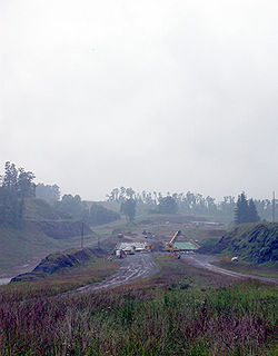
Further eastward, work is continuing on a segment of the Expressway in the vicinity of Sophia
Sophia, West Virginia
Sophia is an incorporated town in Raleigh County, West Virginia, United States. It was incorporated in 1912. The population was 1,301 at the 2000 census. Sophia was the hometown of the late U.S. Senator Robert C. Byrd....
and Crab Orchard
Crab Orchard, West Virginia
Crab Orchard is a census-designated place in Raleigh County, West Virginia, USA. The population was 2,678 at the 2010 census.-Geography:Crab Orchard is located at ....
near Beckley
Beckley, West Virginia
Beckley is a city in Raleigh County, West Virginia, United States, which was founded on April 4, 1838. The 2008 population was estimated to be 16,832 by the U.S. Census Bureau. Early in its history, the town was known as Beckleyville and Raleigh Court House...
totaling 3.5 miles (5.6 km). Grading and preliminary paving operations have been completed, as well as the gradings and bridge construction for a diamond interchange for West Virginia Route 54 and a bridge over West Virginia Route 16. In November 2004, a contract was awarded for paving operations at a cost of $11.5 million from Surveyor Creek Road to the West Virginia Route 16 interchange. With this segment of the Expressway completed, a new tie-in will be complete from Surveyor Creek Road to five-lane West Virginia Route 16, as well as an interchange with West Virginia Route 54.
Two contracts totaling $22.2 million are currently under construction. One projects involves grading and drainage operations on 2.57 miles (4.1 km) of US 121 from Big Ridge to Surveyor Creek Road that involves nearly five million cubic yards of excavation.
Virginia
In Virginia, the Coalfields Expressway will run for 55 miles (88.5 km), following Virginia Route 83 from the West Virginia border to U.S. Highway 23 in PoundPound, Virginia
Pound is a town in Wise County, Virginia, United States. The population was 1,089 as recorded in the 2000 census.-Geography:Pound is located at ....
. Near the Grundy
Grundy, Virginia
Grundy is a town in Buchanan County, Virginia, United States. The population was 1,105 at the 2000 census. It is the county seat of Buchanan County. The town is noted for its educational institutions and their role in the town's economic rebirth. In the past, the town served as a stopover for Union...
- Vansant
Vansant, Virginia
Vansant is a census-designated place in Buchanan County, Virginia, United States. The population was 989 at the 2000 census.-Geography:...
area, U.S. Route 460
U.S. Route 460
U.S. Route 460 is a spur of U.S. Route 60. It currently runs for 655 miles from Norfolk, Virginia at U.S. Route 60 at Ocean View to Frankfort, Kentucky at U.S. Route 60. It passes through the states of Virginia, West Virginia, and Kentucky...
will become a new four lane highway connecting the Coalfields Expressway with Breaks Interstate Park
Breaks Interstate Park
Breaks Interstate Park, also referred as the "Grand Canyon of the South", is located in southeastern Kentucky and southwestern Virginia at the northeastern terminus of Pine Mountain...
at the Virginia
Virginia
The Commonwealth of Virginia , is a U.S. state on the Atlantic Coast of the Southern United States. Virginia is nicknamed the "Old Dominion" and sometimes the "Mother of Presidents" after the eight U.S. presidents born there...
/ Kentucky
Kentucky
The Commonwealth of Kentucky is a state located in the East Central United States of America. As classified by the United States Census Bureau, Kentucky is a Southern state, more specifically in the East South Central region. Kentucky is one of four U.S. states constituted as a commonwealth...
border and Elkhorn City, Kentucky
Elkhorn City, Kentucky
As of the census of 2000, there were 1,060 people, 437 households, and 295 families residing in the city. The population density was 525.5 people per square mile . There were 506 housing units at an average density of 250.8 per square mile...
.
Proposed Interstate 66 connection
Interstate 66Interstate 66
Interstate 66 is an Interstate Highway in the eastern United States. As indicated by its even route number, it runs in an east–west direction. Its western terminus is at Middletown, Virginia, at an intersection with Interstate 81; its eastern terminus is in Washington, D.C., at an...
is a proposed cross-state highway from the far reaches of western Kentucky
Kentucky
The Commonwealth of Kentucky is a state located in the East Central United States of America. As classified by the United States Census Bureau, Kentucky is a Southern state, more specifically in the East South Central region. Kentucky is one of four U.S. states constituted as a commonwealth...
to Pike County
Pike County, Kentucky
Pike County is a county located in the U.S. state of Kentucky. As of 2010, the population was 65,024. Its county seat is Pikeville. Pike is Kentucky's largest county in terms of land area. Pike County is the 11th largest county in Kentucky in terms of population preceded by Bullitt County and...
. The limited-access highway in Pike County would begin at U.S. Route 23 south of Pikeville
Pikeville, Kentucky
Pikeville is a city in Pike County, Kentucky. The population was 6,903 at the 2010 census. It is the county seat of Pike County.-History:On March 25, 1822, the county's government officials decided to build a new county seat named Liberty, one and one-half mile below the mouth of the Russell Fork...
and proceed northeast and north of Fishtrap Lake to Kimper. It would continue to McVeigh along Kentucky Route 199, and cross the Tug Fork River
Tug Fork River
The Tug Fork is a tributary of the Big Sandy River, long, in southwestern West Virginia, southwestern Virginia, and eastern Kentucky in the United States. Via the Big Sandy and Ohio rivers, it is part of the watershed of the Mississippi River....
south of Matewan, West Virginia
Matewan, West Virginia
Matewan is a town in Mingo County, West Virginia, USA at the confluence of the Tug Fork River and Mate Creek. The population was 498 at the 2000 census...
and connect with the King Coal Highway (U.S. Route 52
U.S. Route 52
U.S. Route 52 is a United States highway that runs across the northern, eastern and southeastern regions of the United States. Contrary to most other even-numbered U.S...
) in Mingo County, West Virginia
Mingo County, West Virginia
As of the census of 2000, there were 28,253 people, 11,303 households, and 8,217 families residing in the county. The population density was 67 people per square mile . There were 12,898 housing units at an average density of 30 per square mile...
.
The proposed Interstate 66 would then run south of U.S. Route 119
U.S. Route 119
U.S. Route 119, commonly abbreviated as US 119, is a spur of US 19. It is a north–south route that was an original United States highway of 1926. It is often referred to as Corridor G east of US 23 and KY 80 in Kentucky to Interstate 64 at Charleston, West Virginia.- Kentucky :US 119 is a two...
(Corridor G) but north of US 121 (Coalfields Expressway) and include a new four-lane highway and a two-lane tunnel. All three roadways, Interstate 66, US 121 (Coalfields Expressway), and US 119 (Corridor G) are independent of each other.
As of 2004, the proposal for Interstate 66 in West Virginia is effectively dead. If any Interstate 66
Interstate 66
Interstate 66 is an Interstate Highway in the eastern United States. As indicated by its even route number, it runs in an east–west direction. Its western terminus is at Middletown, Virginia, at an intersection with Interstate 81; its eastern terminus is in Washington, D.C., at an...
routing is made in West Virginia
West Virginia
West Virginia is a state in the Appalachian and Southeastern regions of the United States, bordered by Virginia to the southeast, Kentucky to the southwest, Ohio to the northwest, Pennsylvania to the northeast and Maryland to the east...
, it would most likely follow an upgraded Coalfields Expressway to Beckley.
External links
- Official Virginia DOT Coalfields Expressway Web Site
- Official West Virginia DOT Coalfields Expressway Web Site
See also
- List of U.S. Routes