
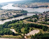
Point Pleasant, West Virginia
Encyclopedia
Mason County, West Virginia
As of the census of 2000, there were 25,957 people, 10,587 households, and 7,569 families residing in the county. The population density was 60 people per square mile . There were 12,056 housing units at an average density of 28 per square mile...
, United States
United States
The United States of America is a federal constitutional republic comprising fifty states and a federal district...
, at the confluence
Confluence (geography)
In geography, a confluence is the meeting of two or more bodies of water. It usually refers to the point where two streams flow together, merging into a single stream...
of the Ohio
Ohio River
The Ohio River is the largest tributary, by volume, of the Mississippi River. At the confluence, the Ohio is even bigger than the Mississippi and, thus, is hydrologically the main stream of the whole river system, including the Allegheny River further upstream...
and Kanawha
Kanawha River
The Kanawha River is a tributary of the Ohio River, approximately 97 mi long, in the U.S. state of West Virginia. The largest inland waterway in West Virginia, it has formed a significant industrial region of the state since the middle of the 19th century.It is formed at the town of Gauley...
rivers. The population was 4,637 at the 2000 census. It is the county seat
County seat
A county seat is an administrative center, or seat of government, for a county or civil parish. The term is primarily used in the United States....
of Mason County
Mason County, West Virginia
As of the census of 2000, there were 25,957 people, 10,587 households, and 7,569 families residing in the county. The population density was 60 people per square mile . There were 12,056 housing units at an average density of 28 per square mile...
and the principal city of the Point Pleasant, WV-OH Micropolitan Statistical Area
Point Pleasant micropolitan area
The Point Pleasant Micropolitan Statistical Area, as defined by the United States Census Bureau, is an area consisting of two counties – one in West Virginia and one in Ohio – anchored by the city of Point Pleasant, West Virginia....
.
The Céloron expedition of 1749
In the second half of 1749 the FrenchFrance
The French Republic , The French Republic , The French Republic , (commonly known as France , is a unitary semi-presidential republic in Western Europe with several overseas territories and islands located on other continents and in the Indian, Pacific, and Atlantic oceans. Metropolitan France...
explorer Pierre Joseph Céloron de Blainville claimed French sovereignty over the Ohio Valley, burying a lead plaque at the meeting point of the Rivers Ohio and Kanawha, naming the place Point Pleasant.
The text on the plaque is as follows:
- L'AN 1749 DV REGNE DE LOVIS XV ROY DE FRANCE, NOVS CELORON, COMMANDANT D'VN DETACHEMENT ENVOIE PAR MONSIEVR LE MIS. DE LA GALISSONIERE, COMMANDANT GENERAL DE LA NOUVELLE FRANCE POVR RETABLIR LA TRAN QUILLITE DANS QUELQUES VILLAGES SAUVAGES DE CES CANTONS, AVONS ENTERRE CETTE PLAQUE AU CONFLUENT DE L'OHIO ET DE TCHADAKOIN CE 29 JVILLET, PRES DE LA RIVIERE OYO AUTREMENT BELLE RIVIERE, POUR MONUMENT DU RENOUVELLEMENT DE POSSESSION QUE NOUS AVONS PRIS DE LA DITTE RIVIERE OYO, ET DE TOUTES CELLE~ QUI Y TOMBENT, ET DE TOUTES LES TERRES DES DEUX COTES JVSQVE AVX SOURCES DES DITTES RIVIERES AINSI QV'EN ONT JOVY OU DV JOVIR LES PRECEDENTS ROIS DE FRANCE, ET QU'ILS S'Y SONT MAINTENVS PAR LES ARMES ET PAR LES TRAIT TES, SPECIALEMENT PAR CEVX DE RISWICK D'VTRECHT ET D'AIX LA CHAPELLE.
- (in the year 1749, in the reign of King Louis XV, we, Celeron, commander of a detachment sent by Commander de La GalissonièreRoland-Michel Barrin de La GalissonièreRoland-Michel Barrin de La Galissonière, Marquis de La Galissonière, sometimes spelled Galissonnière, was the French governor of New France from 1747 to 1749 and the victor in the Battle of Minorca in 1756.- New France :...
, Commander General of New FranceNew FranceNew France was the area colonized by France in North America during a period beginning with the exploration of the Saint Lawrence River by Jacques Cartier in 1534 and ending with the cession of New France to Spain and Great Britain in 1763...
, for the restoration of peace in various untamed villages in the region, have buried ed this plaque at the confluence of the Ohio and Tchadakoin [Rivers] this 29th day of July near the fine river bank, to commemorate the retaking into possession of the afore-mentioned river bank and all the surrounding lands on both river shores back to the river sources, as secured by previous kings of France, and maintained by force of arms and by treaties, specifically the Treaties of RijswickTreaty of RyswickThe Treaty of Ryswick or Ryswyck was signed on 20 September 1697 and named after Ryswick in the Dutch Republic. The treaty settled the Nine Years' War, which pitted France against the Grand Alliance of England, Spain, the Holy Roman Empire and the United Provinces.Negotiations started in May...
, of UtrechtTreaty of UtrechtThe Treaty of Utrecht, which established the Peace of Utrecht, comprises a series of individual peace treaties, rather than a single document, signed by the belligerents in the War of Spanish Succession, in the Dutch city of Utrecht in March and April 1713...
and of Aix la ChapelleTreaty of Aix-la-Chapelle (1748)The Treaty of Aix-la-Chapelle of 1748 ended the War of the Austrian Succession following a congress assembled at the Imperial Free City of Aachen—Aix-la-Chapelle in French—in the west of the Holy Roman Empire, on 24 April 1748...
)
Céloron's expedition was a diplomatic failure since the local tribes
Native American tribes in Virginia
This page details the history and current status of Indian tribes in the Commonwealth of Virginia.All of the Commonwealth of Virginia used to be Virginia Indian territory, an area estimated to have been occupied by indigenous peoples for more than 12,000 years. Their population has been estimated...
remained pro-English, and English representatives in the region refused to go away. This was therefore the prelude to a series of incidents that would lead to the loss of New France
New France
New France was the area colonized by France in North America during a period beginning with the exploration of the Saint Lawrence River by Jacques Cartier in 1534 and ending with the cession of New France to Spain and Great Britain in 1763...
and the domination of northern American by the British Empire
British Empire
The British Empire comprised the dominions, colonies, protectorates, mandates and other territories ruled or administered by the United Kingdom. It originated with the overseas colonies and trading posts established by England in the late 16th and early 17th centuries. At its height, it was the...
, to be followed later in the century by the War of American Independence.
The expedition can nevertheless be seen in more positive terms as a geographical project, since the Céloron expedition was the starting point for the first map of the Ohio Valley. The map was the work of the Jesuit Joseph Pierre de Bonnecamps.
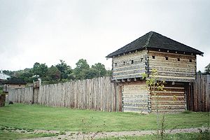
The Battle of Point Pleasant 1774
The town is also noted for the October 10, 1774, Battle of Point PleasantBattle of Point Pleasant
The Battle of Point Pleasant, known as the Battle of Kanawha in some older accounts, was the only major battle of Dunmore's War. It was fought on October 10, 1774, primarily between Virginia militia and American Indians from the Shawnee and Mingo tribes...
, in which 1,100 Virginia militiamen led by Colonel Andrew Lewis
Andrew Lewis (soldier)
Andrew Lewis was an American pioneer, surveyor, and soldier from Virginia. He served as a colonel of militia during the French and Indian War, and as a brigadier general in the American Revolutionary War...
defeated an equal sized force of Algonquin Confederation of Shawnee and Mingo warriors led by Shawnee Chief Cornstalk
Cornstalk
Cornstalk was a prominent leader of the Shawnee nation just prior to the American Revolution. His name, Hokoleskwa, translates loosely into "stalk of corn" in English, and is spelled Colesqua in some accounts...
. The event is celebrated in Point Pleasant as the first battle of the American Revolutionary War
American Revolutionary War
The American Revolutionary War , the American War of Independence, or simply the Revolutionary War, began as a war between the Kingdom of Great Britain and thirteen British colonies in North America, and ended in a global war between several European great powers.The war was the result of the...
, and in 1908 the US Senate authorized erection of a monument to commemorate Point Pleasant as the site of the first battle of the American Revolution. Most historians, however, regard it not as a battle of the Revolution but instead as a part of Lord Dunmore's War.
Civil War Connections
It was the final home of ConfederateConfederate States of America
The Confederate States of America was a government set up from 1861 to 1865 by 11 Southern slave states of the United States of America that had declared their secession from the U.S...
Brigadier-General John McCausland
John McCausland
John McCausland, Jr. was a brigadier general in the Confederate States Army, famous for the ransom of Hagerstown, Maryland, and the razing of Chambersburg, Pennsylvania, during the American Civil War....
, the next-to-last Confederate General to die. He died at his farm at Grimm's Landing on January 23, 1927, and is buried in nearby Henderson
Henderson, West Virginia
Henderson is a town in Mason County, West Virginia, United States, at the confluence of the Ohio and Kanawha Rivers. The population was 325 at the 2000 census. It is part of the Point Pleasant, WV–OH Micropolitan Statistical Area...
.
Bridge Collapse
Point Pleasant is most famous for the 1967 collapse of the Silver BridgeSilver Bridge
The Silver Bridge collapsed in 1967, killing 46 people. The terms Silver Bridge or Silverbridge may also refer to:* Silver Memorial Bridge, the replacement for the above bridge, opened in 1969....
, which killed 46 people.
National Register of Historic Places
The Eastham HouseEastham House
Eastham House, also known as Glenn Manor, is a historic home located at Point Pleasant, Mason County, West Virginia. It was built about 1850, and is a two story, "L"-shaped, brick residence with a low-pitched, slate covered gable roof in the Greek Revival-style. Also on the property is a...
, Lewis-Capehart-Roseberry House
Lewis-Capehart-Roseberry House
Lewis-Capehart-Roseberry House, also known as "Roseberry," is a historic home located at Point Pleasant, Mason County, West Virginia. It was built about 1820, and is a spacious two story, double-pile, brick residence with a gable roof in the Federal-style. It features sandstone lintels and...
, and Point Pleasant Battleground are listed on the National Register of Historic Places
National Register of Historic Places
The National Register of Historic Places is the United States government's official list of districts, sites, buildings, structures, and objects deemed worthy of preservation...
. The central business district and surrounding residential areas are included in the Point Pleasant Historic District
Point Pleasant Historic District (Point Pleasant, West Virginia)
Point Pleasant Historic District is a national historic district located at Point Pleasant, Mason County, West Virginia. The district includes 93 contributing buildings and one contributing site in Point Pleasant's central business district and surrounding residential areas. They are in a variety...
.
The Mothman
Paranormal enthusiasts flock to Point Pleasant in search of MothmanMothman
Mothman is a legendary creature reportedly seen in the Point Pleasant area of West Virginia from 15 November 1966 to 15 December 1967. The first newspaper report was published in the Point Pleasant Register dated 16 November 1966, entitled "Couples See Man-Sized Bird...Creature...Something"...
, a creature said to inhabit an abandoned TNT factory
McClintic Wildlife Management Area
McClintic Wildlife Management Area, known locally as the "TNT area", is located in Mason County about north of Point Pleasant, West Virginia...
from World War II. It has become more than an urban legend, and it is believed to be a harbinger of imminent disaster, now being seen around the globe before great tragedies. John A. Keel published a book in 1975 entitled The Mothman Prophecies
The Mothman Prophecies
The Mothman Prophecies is a 1975 book by author John Keel.The book combines Keel's account of his investigation into alleged sightings of a large, winged creature called Mothman in the vicinity of Point Pleasant, West Virginia, during 1966 and 1967 with his own theories about UFOs and various...
, and a film
The Mothman Prophecies (film)
The Mothman Prophecies is a 2002 psychological horror film directed by Mark Pellington, based on the 1975 book of the same name by parapsychologist and Fortean author John Keel. The screenplay was written by Richard Hatem...
inspired by the novel was released in January 2002. There is even a Mothman Museum, run by Jeffrey Wamsley.
Geography
According to the United States Census BureauUnited States Census Bureau
The United States Census Bureau is the government agency that is responsible for the United States Census. It also gathers other national demographic and economic data...
, the city has a total area of 3.1 square miles (8.0 km²), of which, 2.4 square miles (6.2 km²) of it is land and 0.7 square miles (1.8 km²) of it (22.73%) is water.
Point Pleasant is located at 38°51′27"N 82°7′43"W (38.857527, -82.128571).
Demographics
As of the censusCensus
A census is the procedure of systematically acquiring and recording information about the members of a given population. It is a regularly occurring and official count of a particular population. The term is used mostly in connection with national population and housing censuses; other common...
of 2000, there were 4,637 people, 2,107 households, and 1,310 families residing in the city. The population density
Population density
Population density is a measurement of population per unit area or unit volume. It is frequently applied to living organisms, and particularly to humans...
was 1,945.6 people per square mile (752.3/km²). There were 2,313 housing units at an average density of 970.5 per square mile (375.2/km²). The racial makeup of the city was 96.57% White, 1.90% African American, 0.15% Native American, 0.60% Asian, 0.09% from other races
Race (United States Census)
Race and ethnicity in the United States Census, as defined by the Federal Office of Management and Budget and the United States Census Bureau, are self-identification data items in which residents choose the race or races with which they most closely identify, and indicate whether or not they are...
, and 0.69% from two or more races. Hispanic or Latino of any race were 0.54% of the population.
There were 2,107 households out of which 26.3% had children under the age of 18 living with them, 44.7% were married couples
Marriage
Marriage is a social union or legal contract between people that creates kinship. It is an institution in which interpersonal relationships, usually intimate and sexual, are acknowledged in a variety of ways, depending on the culture or subculture in which it is found...
living together, 14.4% had a female householder with no husband present, and 37.8% were non-families. 34.8% of all households were made up of individuals and 17.8% had someone living alone who was 65 years of age or older. The average household size was 2.18 and the average family size was 2.80.
In the city the population was spread out with 21.3% under the age of 18, 8.4% from 18 to 24, 23.7% from 25 to 44, 26.2% from 45 to 64, and 20.4% who were 65 years of age or older. The median age was 43 years. For every 100 females there were 83.6 males. For every 100 females age 18 and over, there were 75.3 males.
The median income for a household in the city was $27,022, and the median income for a family was $33,527. Males had a median income of $31,657 versus $16,607 for females. The per capita income
Per capita income
Per capita income or income per person is a measure of mean income within an economic aggregate, such as a country or city. It is calculated by taking a measure of all sources of income in the aggregate and dividing it by the total population...
for the city was $16,692. About 22.2% of families and 24.2% of the population were below the poverty line, including 37.9% of those under age 18 and 13.3% of those age 65 or over.
See also
- List of cities and towns along the Ohio River
- The Lost Souls of Bell Valley (book)The Lost Souls of Bell Valley (book)The Lost Souls of Bell Valley is a horror fiction book written by A.D. Distler.The story is set primarily in southern Ohio and is based on two actual events that occurred in the region, about seventy air miles and forty years apart...