
Kanawha River
Encyclopedia
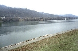
The Kanawha River is a tributary of the Ohio River
, approximately 97 mi (156 km) long, in the U.S. state
of West Virginia
. The largest inland waterway in West Virginia, it has formed a significant industrial region of the state since the middle of the 19th century.
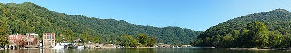
It is formed at the town of Gauley Bridge
in northwestern Fayette County
, approximately 35 mi (56 km) SE of Charleston
, by the confluence
of the New and Gauley
rivers. It flows generally northwest, in a winding course on the unglaciated Allegheny Plateau
, through Fayette, Kanawha
, Putnam
and Mason
Counties, past the cities of Charleston and St. Albans
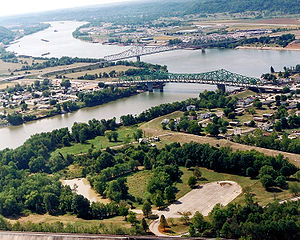
and numerous smaller communities. It joins the Ohio at Point Pleasant
.
Paleo-Indians, the earliest indigenous peoples
, lived in the valley and the heights by 10,000 BCE, as evidenced by archaeological artifacts such as Clovis points. A succession of prehistoric cultures developed, with the Adena culture
beginning the construction of numerous skilled earthwork mounds and enclosure
s more than 1000 years ago. Some of the villages of the Fort Ancient culture survived into the times of European contact. The area was a place of competition among historical Native Americans, as the Iroquois
' invading from present-day New York
drove out or conquered Fort Ancient-culture peoples, as well as such tribes as the Huron and Conoy. The Iroquois, Delaware
and Shawnee
kept the area as a hunting
ground and resisted European-American settlement in the colonial years.
The river valley contains significant deposits of coal
and natural gas
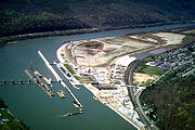
. In colonial times, the wildly fluctuating level of the river prevented its use for transportation. The removal of boulders and snags on the lower river in the 1840s allowed navigation, extended after the construction of locks and dams starting in 1875. The river is now navigable to Deepwater
, an unincorporated community about 20 miles (32.2 km) upriver from Charleston. A thriving chemical industry along its banks provides a significant part of the local economy.
, the Kanawha is joined at Charleston by the Elk River
, at St. Albans by the Coal River
, and at Poca
by the Pocatalico River
.
 ]
]
According to the Geographic Names Information System
, the Kanawha River has also been known as:
"Ka(ih)nawha" derives from the region's Iroquoian dialects meaning "water way" or "canoe way" implying the metaphor, "transport way", in the local language. The Glottal consonant
of the "ih" (stream or river, local Iroquois) dropped out as few European settlers and homesteaders were fluent with any of the dialects of Iroquois.
living in the area from as early as 12,500 BCE. Peoples of later cultures continued to live along the valley and heights. Those of the Adena culture
built at least 50 earthwork mounds
and 10 enclosure
s in the area between Charleston
and Dunbar
, as identified by an 1882 to 1884 survey by the Bureau of Ethnology (later part of the Smithsonian Institution
). Three of their mounds survive in the valley, including Criel Mound
at present-day South Charleston, West Virginia
. Evidence has been found of the Fort Ancient culture peoples, who had villages that survived to the time of European contact, such as Buffalo
and Marmet
. They were driven out by Iroquois
from present-day New York
.
According to French missionary
reports, by the late 16th century, several thousand Huron, originally of the Great Lakes
region, lived in central West Virginia. They were driven out in the 17th century by the Iroquois
' invading from western present-day New York. Other accounts note that the tribe known as Conois, Conoy or Canawesee, were conquered or driven out by the large Seneca
tribe, one of the Iroquois Confederacy, as the Seneca boasted to Virginia
colonial
officials in 1744. The Iroquois and other tribes, such as the Shawnee
and Delaware
, maintained central West Virginia as a hunting ground. It was essentially unpopulated when the English
and Europe
ans began to move into the area.
Those whom actually came to the Great Kanawha, quoting Captain Hanson in April 1774 "18th. We surveyed 2,000 acres (8.1 km2) of Land for Col. Washington, bordered by Coal River & the Canawagh..." This area is the lower area of today's St. Albans, West Virginia
. After the Treaty of Fort Stanwix
-- "The Kanawhas had gone from the upper tributaries of the river which bears their name, to join their kinsmen, the Iroquois in New York; the Shawnee had abandoned the Indian Old Fields of the valley of the South Branch of the Potomac; the Delaware were gone from the Monongahela; the Cherokee who claimed all the region between the Great Kanawha and Big Sandy, had never occupied it." quoting Virgil A. Lewis (1887), Corresponding member of the Virginia Historical Society. Virgil's grandfather was a western Virginia surveyor, Andrew Lewis (soldier)
, who surveyed the Kanawha's tributaries in the middle 18th Century. The river's name changes to the Kanawha River at the Kanawha Falls
. Lewis was granted a large tract of land near the mouth of the Great Kanawha River in the late 18th Century.
The Little Kanawha
and the Great Kanawha rivers, the two largest in the state, were named for the American Indian tribe that lived in the area prior to European settlement in the 18th century. Under pressure from the Iroquois, most of the Conoy had migrated to present-day Virginia by 1634, where they had settled on the west side of the Chesapeake Bay
and below the Potomac River
. They were also known to the colonists there as the Piscataway. They later migrated north to Pennsylvania
, to submit and seek protection with the Susquehannock
and Iroquois. The spelling of the Indian tribe varied at the time, from Conoys to Conois to Kanawha. "The latter spelling was used and has gained acceptance over time," according to scholars at West Virginia University
.
Ohio River
The Ohio River is the largest tributary, by volume, of the Mississippi River. At the confluence, the Ohio is even bigger than the Mississippi and, thus, is hydrologically the main stream of the whole river system, including the Allegheny River further upstream...
, approximately 97 mi (156 km) long, in the U.S. state
U.S. state
A U.S. state is any one of the 50 federated states of the United States of America that share sovereignty with the federal government. Because of this shared sovereignty, an American is a citizen both of the federal entity and of his or her state of domicile. Four states use the official title of...
of West Virginia
West Virginia
West Virginia is a state in the Appalachian and Southeastern regions of the United States, bordered by Virginia to the southeast, Kentucky to the southwest, Ohio to the northwest, Pennsylvania to the northeast and Maryland to the east...
. The largest inland waterway in West Virginia, it has formed a significant industrial region of the state since the middle of the 19th century.
It is formed at the town of Gauley Bridge
Gauley Bridge, West Virginia
Gauley Bridge is a town in Fayette County, West Virginia, United States. The population was 738 at the 2000 census. The Kanawha River is formed at Gauley Bridge by the confluence of the New and Gauley Rivers...
in northwestern Fayette County
Fayette County, West Virginia
As of the census of 2000, there were 47,579 people, 18,945 households, and 13,128 families residing in the county. The population density was 72 people per square mile . There were 21,616 housing units at an average density of 33 per square mile...
, approximately 35 mi (56 km) SE of Charleston
Charleston, West Virginia
Charleston is the capital and largest city of the U.S. state of West Virginia. It is located at the confluence of the Elk and Kanawha Rivers in Kanawha County. As of the 2010 census, it has a population of 51,400, and its metropolitan area 304,214. It is the county seat of Kanawha County.Early...
, by the confluence
Confluence (geography)
In geography, a confluence is the meeting of two or more bodies of water. It usually refers to the point where two streams flow together, merging into a single stream...
of the New and Gauley
Gauley River
The Gauley River is a river in West Virginia. It merges with the New River to form the Kanawha River, a tributary of the Ohio River. It is one of the most popular advanced whitewater runs in the Eastern United States and is the chief feature of the Gauley River National Recreation Area.-Headwaters...
rivers. It flows generally northwest, in a winding course on the unglaciated Allegheny Plateau
Allegheny Plateau
The Allegheny Plateau is a large dissected plateau area in western and central New York, northern and western Pennsylvania, northern and western West Virginia, and eastern Ohio...
, through Fayette, Kanawha
Kanawha County, West Virginia
As of the census of 2000, there were 200,073 people, 86,226 households, and 55,960 families residing in the county. The population density was 222 people per square mile . There were 93,788 housing units at an average density of 104 per square mile...
, Putnam
Putnam County, West Virginia
As of the census of 2000, there were 51,589 people, 20,028 households, and 15,281 families residing in the county. The population density was 149 people per square mile . There were 21,621 housing units at an average density of 62 per square mile...
and Mason
Mason County, West Virginia
As of the census of 2000, there were 25,957 people, 10,587 households, and 7,569 families residing in the county. The population density was 60 people per square mile . There were 12,056 housing units at an average density of 28 per square mile...
Counties, past the cities of Charleston and St. Albans
St. Albans, West Virginia
St. Albans is a city in Kanawha County, West Virginia, United States, at the confluence of the Kanawha and Coal Rivers. The population was 11,044 at the 2010 census.St. Albans was laid out in 1816...
and numerous smaller communities. It joins the Ohio at Point Pleasant
Point Pleasant, West Virginia
Point Pleasant is a city in Mason County, West Virginia, United States, at the confluence of the Ohio and Kanawha rivers. The population was 4,637 at the 2000 census...
.
Paleo-Indians, the earliest indigenous peoples
Indigenous peoples
Indigenous peoples are ethnic groups that are defined as indigenous according to one of the various definitions of the term, there is no universally accepted definition but most of which carry connotations of being the "original inhabitants" of a territory....
, lived in the valley and the heights by 10,000 BCE, as evidenced by archaeological artifacts such as Clovis points. A succession of prehistoric cultures developed, with the Adena culture
Adena culture
The Adena culture was a Pre-Columbian Native American culture that existed from 1000 to 200 BC, in a time known as the early Woodland Period. The Adena culture refers to what were probably a number of related Native American societies sharing a burial complex and ceremonial system...
beginning the construction of numerous skilled earthwork mounds and enclosure
Enclosure (archaeology)
In archaeology, an enclosure is one of the most common types of archaeological site. It is any area of land separated from surrounding land by earthworks, walls or fencing. Such a simple feature is found all over the world and during almost all archaeological periods...
s more than 1000 years ago. Some of the villages of the Fort Ancient culture survived into the times of European contact. The area was a place of competition among historical Native Americans, as the Iroquois
Iroquois
The Iroquois , also known as the Haudenosaunee or the "People of the Longhouse", are an association of several tribes of indigenous people of North America...
' invading from present-day New York
New York
New York is a state in the Northeastern region of the United States. It is the nation's third most populous state. New York is bordered by New Jersey and Pennsylvania to the south, and by Connecticut, Massachusetts and Vermont to the east...
drove out or conquered Fort Ancient-culture peoples, as well as such tribes as the Huron and Conoy. The Iroquois, Delaware
Delaware
Delaware is a U.S. state located on the Atlantic Coast in the Mid-Atlantic region of the United States. It is bordered to the south and west by Maryland, and to the north by Pennsylvania...
and Shawnee
Shawnee
The Shawnee, Shaawanwaki, Shaawanooki and Shaawanowi lenaweeki, are an Algonquian-speaking people native to North America. Historically they inhabited the areas of Ohio, Virginia, West Virginia, Western Maryland, Kentucky, Indiana, and Pennsylvania...
kept the area as a hunting
Hunting
Hunting is the practice of pursuing any living thing, usually wildlife, for food, recreation, or trade. In present-day use, the term refers to lawful hunting, as distinguished from poaching, which is the killing, trapping or capture of the hunted species contrary to applicable law...
ground and resisted European-American settlement in the colonial years.
The river valley contains significant deposits of coal
Coal
Coal is a combustible black or brownish-black sedimentary rock usually occurring in rock strata in layers or veins called coal beds or coal seams. The harder forms, such as anthracite coal, can be regarded as metamorphic rock because of later exposure to elevated temperature and pressure...
and natural gas
Natural gas
Natural gas is a naturally occurring gas mixture consisting primarily of methane, typically with 0–20% higher hydrocarbons . It is found associated with other hydrocarbon fuel, in coal beds, as methane clathrates, and is an important fuel source and a major feedstock for fertilizers.Most natural...
. In colonial times, the wildly fluctuating level of the river prevented its use for transportation. The removal of boulders and snags on the lower river in the 1840s allowed navigation, extended after the construction of locks and dams starting in 1875. The river is now navigable to Deepwater
Deepwater, West Virginia
Deep Water, also known historically as Deepwater, is an unincorporated census-designated place on the Kanawha River in Fayette County, West Virginia, United States. As of the 2010 census, its population was 280. It is best known as the starting point of the Deepwater Railway founded in 1898 by...
, an unincorporated community about 20 miles (32.2 km) upriver from Charleston. A thriving chemical industry along its banks provides a significant part of the local economy.
Tributaries
In addition to the New and Gauley RiverGauley River
The Gauley River is a river in West Virginia. It merges with the New River to form the Kanawha River, a tributary of the Ohio River. It is one of the most popular advanced whitewater runs in the Eastern United States and is the chief feature of the Gauley River National Recreation Area.-Headwaters...
, the Kanawha is joined at Charleston by the Elk River
Elk River (West Virginia)
The Elk River is a tributary of the Kanawha River, long, in central West Virginia in the United States. Via the Kanawha and Ohio Rivers, it is part of the watershed of the Mississippi River.-Course:...
, at St. Albans by the Coal River
Coal River (West Virginia)
The Coal River is a tributary of the Kanawha River in southern West Virginia. It is formed near the community of Alum Creek by the confluence of the Big and Little Coal Rivers, and flows generally northward through western Kanawha County, past the community of Upper Falls and into the Kanawha...
, and at Poca
Poca, West Virginia
Poca is a town in Putnam County, West Virginia, United States. The population was 974 at the 2010 census.-Geography:Poca is located at . It is sited at the confluence of the Kanawha River and the Pocatalico River....
by the Pocatalico River
Pocatalico River
The Pocatalico River is a tributary of the Kanawha River, about 75 mi long, in west-central West Virginia in the United States. Via the Kanawha and Ohio Rivers, it is part of the Mississippi River watershed....
.
List of cities and towns along the Kanawha River
|
Jefferson, West Virginia Jefferson is an unincorporated census-designated place in Kanawha County, West Virginia, United States, along the Kanawha River. The population was 676 at the 2010 census... Leon, West Virginia Leon is a town in Mason County, West Virginia, United States, along the Kanawha River. The population was 132 at the 2000 census. It is part of the Point Pleasant, WV–OH Micropolitan Statistical Area.-History:The Gen... Marmet, West Virginia Marmet is a city in Kanawha County, West Virginia, USA, along the Kanawha River.-Geography:Marmet is located at .According to the United States Census Bureau, the city has a total area of 1.5 square miles , of which, 1.4 square miles of it is land and 0.1 square miles of it is... Montgomery, West Virginia Montgomery is a city in West Virginia, along the Kanawha River. Most of the city is in Fayette County, with the remainder in Kanawha County. As of the 2000 census, the city population was 1,942 .... Nitro, West Virginia Nitro is a city in West Virginia, along the Kanawha River. Most of the city lies in Kanawha County, with the remainder in Putnam County. The population was 7,178 at the 2010 census.Nitro was incorporated in 1932 by Circuit Court.- City name origin :... Poca, West Virginia Poca is a town in Putnam County, West Virginia, United States. The population was 974 at the 2010 census.-Geography:Poca is located at . It is sited at the confluence of the Kanawha River and the Pocatalico River.... Point Pleasant, West Virginia Point Pleasant is a city in Mason County, West Virginia, United States, at the confluence of the Ohio and Kanawha rivers. The population was 4,637 at the 2000 census... Pratt, West Virginia Pratt is a town in Kanawha County, West Virginia, United States, along the Kanawha River. The population was 551 at the 2000 census.-History:The Pratt Historic District is listed on the National Register of Historic Places.-Geography:... St. Albans, West Virginia St. Albans is a city in Kanawha County, West Virginia, United States, at the confluence of the Kanawha and Coal Rivers. The population was 11,044 at the 2010 census.St. Albans was laid out in 1816... Smithers, West Virginia Smithers is a city in West Virginia, along the Kanawha River. Almost all of the city is in Fayette County, with a very small part in Kanawha County. As of the 2000 census, the city population was 904... South Charleston, West Virginia South Charleston is a city in Kanawha County, West Virginia, U.S. The population was 13,450 at the 2010 census. South Charleston was established in 1906, but not incorporated until 1919 by special charter enacted by the West Virginia Legislature... Winfield, West Virginia Winfield is a town in Putnam County, West Virginia, along the Kanawha River. The population was 2,301 at the 2010 census. It is the county seat of Putnam County.... |
Variant names
According to the Geographic Names Information System
Geographic Names Information System
The Geographic Names Information System is a database that contains name and locative information about more than two million physical and cultural features located throughout the United States of America and its territories. It is a type of gazetteer...
, the Kanawha River has also been known as:
|
|
New River (West Virginia) The New River, part of the Ohio River watershed, is a tributary of the Kanawha River about 320 mi long. The river flows through the U.S. states of North Carolina, Virginia, and West Virginia... |
"Ka(ih)nawha" derives from the region's Iroquoian dialects meaning "water way" or "canoe way" implying the metaphor, "transport way", in the local language. The Glottal consonant
Glottal consonant
Glottal consonants, also called laryngeal consonants, are consonants articulated with the glottis. Many phoneticians consider them, or at least the so-called fricative, to be transitional states of the glottis without a point of articulation as other consonants have; in fact, some do not consider...
of the "ih" (stream or river, local Iroquois) dropped out as few European settlers and homesteaders were fluent with any of the dialects of Iroquois.
History
Archaeological artifacts, such as Clovis points and later projectiles, indicate prehistoric indigenous peoplesIndigenous peoples
Indigenous peoples are ethnic groups that are defined as indigenous according to one of the various definitions of the term, there is no universally accepted definition but most of which carry connotations of being the "original inhabitants" of a territory....
living in the area from as early as 12,500 BCE. Peoples of later cultures continued to live along the valley and heights. Those of the Adena culture
Adena culture
The Adena culture was a Pre-Columbian Native American culture that existed from 1000 to 200 BC, in a time known as the early Woodland Period. The Adena culture refers to what were probably a number of related Native American societies sharing a burial complex and ceremonial system...
built at least 50 earthwork mounds
Earthworks (archaeology)
In archaeology, earthwork is a general term to describe artificial changes in land level. Earthworks are often known colloquially as 'lumps and bumps'. Earthworks can themselves be archaeological features or they can show features beneath the surface...
and 10 enclosure
Enclosure (archaeology)
In archaeology, an enclosure is one of the most common types of archaeological site. It is any area of land separated from surrounding land by earthworks, walls or fencing. Such a simple feature is found all over the world and during almost all archaeological periods...
s in the area between Charleston
Charleston, West Virginia
Charleston is the capital and largest city of the U.S. state of West Virginia. It is located at the confluence of the Elk and Kanawha Rivers in Kanawha County. As of the 2010 census, it has a population of 51,400, and its metropolitan area 304,214. It is the county seat of Kanawha County.Early...
and Dunbar
Dunbar, West Virginia
Dunbar is a city in Kanawha County, West Virginia, along the Kanawha River. The population was 7,907 at the 2010 census estimate. Dunbar was incorporated on April 19, 1921, by an Act of the West Virginia Legislature, and named for Dunbar Baines, a prominent area banker.-History:Located at Dunbar is...
, as identified by an 1882 to 1884 survey by the Bureau of Ethnology (later part of the Smithsonian Institution
Smithsonian Institution
The Smithsonian Institution is an educational and research institute and associated museum complex, administered and funded by the government of the United States and by funds from its endowment, contributions, and profits from its retail operations, concessions, licensing activities, and magazines...
). Three of their mounds survive in the valley, including Criel Mound
Criel Mound
The Criel Mound is a Native American burial mound located in South Charleston, West Virginia, USA. The mound was built by the Adena culture, probably around 250-150 BC, and lay equidistant between two “sacred circles”, earthwork enclosures each in diameter. It was originally high and in...
at present-day South Charleston, West Virginia
South Charleston, West Virginia
South Charleston is a city in Kanawha County, West Virginia, U.S. The population was 13,450 at the 2010 census. South Charleston was established in 1906, but not incorporated until 1919 by special charter enacted by the West Virginia Legislature...
. Evidence has been found of the Fort Ancient culture peoples, who had villages that survived to the time of European contact, such as Buffalo
Buffalo, West Virginia
Buffalo is a town in Putnam County, West Virginia, along the Kanawha River. The population was 1,236 at the 2010 census.-Geography:Buffalo is located at .According to the United States Census Bureau, the town has a total area of...
and Marmet
Marmet, West Virginia
Marmet is a city in Kanawha County, West Virginia, USA, along the Kanawha River.-Geography:Marmet is located at .According to the United States Census Bureau, the city has a total area of 1.5 square miles , of which, 1.4 square miles of it is land and 0.1 square miles of it is...
. They were driven out by Iroquois
Iroquois
The Iroquois , also known as the Haudenosaunee or the "People of the Longhouse", are an association of several tribes of indigenous people of North America...
from present-day New York
New York
New York is a state in the Northeastern region of the United States. It is the nation's third most populous state. New York is bordered by New Jersey and Pennsylvania to the south, and by Connecticut, Massachusetts and Vermont to the east...
.
According to French missionary
Missionary
A missionary is a member of a religious group sent into an area to do evangelism or ministries of service, such as education, literacy, social justice, health care and economic development. The word "mission" originates from 1598 when the Jesuits sent members abroad, derived from the Latin...
reports, by the late 16th century, several thousand Huron, originally of the Great Lakes
Great Lakes
The Great Lakes are a collection of freshwater lakes located in northeastern North America, on the Canada – United States border. Consisting of Lakes Superior, Michigan, Huron, Erie, and Ontario, they form the largest group of freshwater lakes on Earth by total surface, coming in second by volume...
region, lived in central West Virginia. They were driven out in the 17th century by the Iroquois
Iroquois
The Iroquois , also known as the Haudenosaunee or the "People of the Longhouse", are an association of several tribes of indigenous people of North America...
' invading from western present-day New York. Other accounts note that the tribe known as Conois, Conoy or Canawesee, were conquered or driven out by the large Seneca
Seneca nation
The Seneca are a group of indigenous people native to North America. They were the nation located farthest to the west within the Six Nations or Iroquois League in New York before the American Revolution. While exact population figures are unknown, approximately 15,000 to 25,000 Seneca live in...
tribe, one of the Iroquois Confederacy, as the Seneca boasted to Virginia
Virginia
The Commonwealth of Virginia , is a U.S. state on the Atlantic Coast of the Southern United States. Virginia is nicknamed the "Old Dominion" and sometimes the "Mother of Presidents" after the eight U.S. presidents born there...
colonial
Colony
In politics and history, a colony is a territory under the immediate political control of a state. For colonies in antiquity, city-states would often found their own colonies. Some colonies were historically countries, while others were territories without definite statehood from their inception....
officials in 1744. The Iroquois and other tribes, such as the Shawnee
Shawnee
The Shawnee, Shaawanwaki, Shaawanooki and Shaawanowi lenaweeki, are an Algonquian-speaking people native to North America. Historically they inhabited the areas of Ohio, Virginia, West Virginia, Western Maryland, Kentucky, Indiana, and Pennsylvania...
and Delaware
Delaware
Delaware is a U.S. state located on the Atlantic Coast in the Mid-Atlantic region of the United States. It is bordered to the south and west by Maryland, and to the north by Pennsylvania...
, maintained central West Virginia as a hunting ground. It was essentially unpopulated when the English
England
England is a country that is part of the United Kingdom. It shares land borders with Scotland to the north and Wales to the west; the Irish Sea is to the north west, the Celtic Sea to the south west, with the North Sea to the east and the English Channel to the south separating it from continental...
and Europe
Europe
Europe is, by convention, one of the world's seven continents. Comprising the westernmost peninsula of Eurasia, Europe is generally 'divided' from Asia to its east by the watershed divides of the Ural and Caucasus Mountains, the Ural River, the Caspian and Black Seas, and the waterways connecting...
ans began to move into the area.
Those whom actually came to the Great Kanawha, quoting Captain Hanson in April 1774 "18th. We surveyed 2,000 acres (8.1 km2) of Land for Col. Washington, bordered by Coal River & the Canawagh..." This area is the lower area of today's St. Albans, West Virginia
St. Albans, West Virginia
St. Albans is a city in Kanawha County, West Virginia, United States, at the confluence of the Kanawha and Coal Rivers. The population was 11,044 at the 2010 census.St. Albans was laid out in 1816...
. After the Treaty of Fort Stanwix
Treaty of Fort Stanwix
The Treaty of Fort Stanwix was an important treaty between North American Indians and the British Empire. It was signed in 1768 at Fort Stanwix, located in present-day Rome, New York...
-- "The Kanawhas had gone from the upper tributaries of the river which bears their name, to join their kinsmen, the Iroquois in New York; the Shawnee had abandoned the Indian Old Fields of the valley of the South Branch of the Potomac; the Delaware were gone from the Monongahela; the Cherokee who claimed all the region between the Great Kanawha and Big Sandy, had never occupied it." quoting Virgil A. Lewis (1887), Corresponding member of the Virginia Historical Society. Virgil's grandfather was a western Virginia surveyor, Andrew Lewis (soldier)
Andrew Lewis (soldier)
Andrew Lewis was an American pioneer, surveyor, and soldier from Virginia. He served as a colonel of militia during the French and Indian War, and as a brigadier general in the American Revolutionary War...
, who surveyed the Kanawha's tributaries in the middle 18th Century. The river's name changes to the Kanawha River at the Kanawha Falls
Glen Ferris, West Virginia
Glen Ferris is an unincorporated census-designated place on the western bank of the Kanawha River in Fayette County, West Virginia. It is situated approximately one mile south of the town of Gauley Bridge. The sole highway linking Glen Ferris to the area is U.S. Route 60, known also as the Midland...
. Lewis was granted a large tract of land near the mouth of the Great Kanawha River in the late 18th Century.
The Little Kanawha
Little Kanawha River
The Little Kanawha River is a tributary of the Ohio River, 169 mi long, in western West Virginia in the United States. Via the Ohio, it is part of the watershed of the Mississippi River, draining an area of 2,320 mi² on the unglaciated portion of the Allegheny Plateau...
and the Great Kanawha rivers, the two largest in the state, were named for the American Indian tribe that lived in the area prior to European settlement in the 18th century. Under pressure from the Iroquois, most of the Conoy had migrated to present-day Virginia by 1634, where they had settled on the west side of the Chesapeake Bay
Chesapeake Bay
The Chesapeake Bay is the largest estuary in the United States. It lies off the Atlantic Ocean, surrounded by Maryland and Virginia. The Chesapeake Bay's drainage basin covers in the District of Columbia and parts of six states: New York, Pennsylvania, Delaware, Maryland, Virginia, and West...
and below the Potomac River
Potomac River
The Potomac River flows into the Chesapeake Bay, located along the mid-Atlantic coast of the United States. The river is approximately long, with a drainage area of about 14,700 square miles...
. They were also known to the colonists there as the Piscataway. They later migrated north to Pennsylvania
Pennsylvania
The Commonwealth of Pennsylvania is a U.S. state that is located in the Northeastern and Mid-Atlantic regions of the United States. The state borders Delaware and Maryland to the south, West Virginia to the southwest, Ohio to the west, New York and Ontario, Canada, to the north, and New Jersey to...
, to submit and seek protection with the Susquehannock
Susquehannock
The Susquehannock people were Iroquoian-speaking Native Americans who lived in areas adjacent to the Susquehanna River and its tributaries from the southern part of what is now New York, through Pennsylvania, to the mouth of the Susquehanna in Maryland at the north end of the Chesapeake Bay...
and Iroquois. The spelling of the Indian tribe varied at the time, from Conoys to Conois to Kanawha. "The latter spelling was used and has gained acceptance over time," according to scholars at West Virginia University
West Virginia University
West Virginia University is a public research university in Morgantown, West Virginia, USA. Other campuses include: West Virginia University at Parkersburg in Parkersburg; West Virginia University Institute of Technology in Montgomery; Potomac State College of West Virginia University in Keyser;...
.
Highways
- Interstate 64Interstate 64Interstate 64 is an Interstate Highway in the Midwestern and Southeastern United States. Its western terminus is at I-70, U.S. 40, and U.S. 61 in Wentzville, Missouri. Its eastern terminus is at an interchange with I-264 and I-664 at Bowers Hill in Chesapeake, Virginia. As I-64 is concurrent with...
crosses the Kanawha four times on major bridges in the Charleston vicinity.
See also
- List of West Virginia rivers
- Little Kanawha RiverLittle Kanawha RiverThe Little Kanawha River is a tributary of the Ohio River, 169 mi long, in western West Virginia in the United States. Via the Ohio, it is part of the watershed of the Mississippi River, draining an area of 2,320 mi² on the unglaciated portion of the Allegheny Plateau...
- Kanawha River Valley AVAKanawha River Valley AVAThe Kanawha River Valley AVA is an American Viticultural Area located in the watershed of the Kanawha River in West Virginia, between the city of Charleston and the Ohio border. The wine appellation includes in portions of Cabell, Jackson, Kanawha, Mason, and Putnam counties. A portion of the...
, an American Viticultural AreaAmerican Viticultural AreaAn American Viticultural Area is a designated wine grape-growing region in the United States distinguishable by geographic features, with boundaries defined by the Alcohol and Tobacco Tax and Trade Bureau , United States Department of the Treasury.... - USS Kanawha (AO-1)USS Kanawha (AO-1)The third USS Kanawha was a replenishment oiler of the US Navy. She was laid down 8 December 1913 by the Mare Island Navy Yard, Vallejo, California; launched 11 July 1914; sponsored by Miss Dorothy Bennett; and commissioned 5 June 1915, Lt. Comdr...
— a fleet oiler built in 1914. - KanawhaKanawha (1899)Kanawha was a 471-ton steam-powered luxury yacht initially built in 1899 for millionaire industrialist and financier Henry Huttleston Rogers . One of the key men in the Standard Oil Trust, Rogers was one of the last of the robber barons of the Gilded Age in the United States...
a steam-powered luxury yachtYachtA yacht is a recreational boat or ship. The term originated from the Dutch Jacht meaning "hunt". It was originally defined as a light fast sailing vessel used by the Dutch navy to pursue pirates and other transgressors around and into the shallow waters of the Low Countries...
built in 1899 which was owned by Henry Huttleston RogersHenry H. RogersHenry Huttleston Rogers was a United States capitalist, businessman, industrialist, financier, and philanthropist. He made his fortune in the oil refinery business, becoming a leader at Standard Oil....
, developer of coalCoalCoal is a combustible black or brownish-black sedimentary rock usually occurring in rock strata in layers or veins called coal beds or coal seams. The harder forms, such as anthracite coal, can be regarded as metamorphic rock because of later exposure to elevated temperature and pressure...
and railroad properties in southern West Virginia, including the $40 million dollar Virginian RailwayVirginian RailwayThe Virginian Railway was a Class I railroad located in Virginia and West Virginia in the United States. The VGN was created to transport high quality "smokeless" bituminous coal from southern West Virginia to port at Hampton Roads.... - The General Frank M. Coxe (ship)General Frank M. Coxe (ship)The General Frank M. Coxe is a steam ferry which was built for the United States Army to provide transportation services among several military facilities which ring California's San Francisco Bay....
built in Charleston, served as an Army transport vessel and now preserved as a floating restaurant. - West Virginia WaterwaysWest Virginia WaterwaysWest Virginia waterways find their highest sources in the highland watersheds of the Allegheny Mountains. These watersheds supply drainage to the creeks often passing through deep and narrow hollows. From the hollows, rushing highland streams collect in bottom land brooks and rivers...
- Charleston, West Virginia metropolitan area, often called the "Kanawha Valley" by locals
Further reading
- Arthur Benke & Colbert Cushing, Rivers of North America, Elsevier Academic Press, 2005 ISBN 0-12-088253-1
- Atkinson, George W. 1876. History of Kanawha County, From. . . 1789 Until the Present Time, Charleston: West Virginia Journal Office.
- Dayton, Ruth Woods. 1947. Pioneers and Their Homes on Upper Kanawha, Charleston: West Virginia Publishing Company.
- Laidley, W. S. 1911. History of Charleston and Kanawha County, West Virginia, Chicago: Richmond-Arnold Publishing Company
- Lewis, Thomas M. N. and Madeline Kneberg. 1958. Tribes That Slumber, Knoxville, TN: The University of Tennessee Press
- McMichael, Edward V. 1968. Introduction to West Virginia Archeology, Morgantown, WVA: West Virginia Geological and Economic Survey
- Rhodes, Captain Rick, The Ohio River in American History and Voyaging on Today's River. Heron Island Guides, 2007, ISBN 978-0-9665866-3-3
- Thomas, Cyrus. 1894. Report on the Mound Explorations of the Bureau of Ethnology. Smithsonian Institution Press