

Thirteener
Encyclopedia
In mountaineering
in the United States, a thirteener is a mountain
that exceeds 13000 feet (3,962.4 m) above mean sea level
, similar to the more familiar "fourteener
s," which exceed 14000 feet (4,267.2 m). In most instances, "thirteeners" refers only to those peaks between 13,000 and 13,999 feet in elevation.
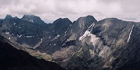
The importance of thirteeners is greatest in Colorado
, which has the majority of such peaks in North America
with over 600 of them. Despite the daunting number of peaks, a few dedicated peak baggers
have successfully managed to climb all of Colorado's thirteeners. Thirteeners are also significant in states whose highpoints fall between 13,000 and 13,999 feet. Regarding whether or not peaks in excess of 13,999 feet should be considered as "thirteeners", this article will count them as such for statistical purposes, but concentrate its focus on those peaks less than 14,000 feet since the higher peaks are already covered in the fourteener
s list.
Not all summits over 13,000 feet qualify as thirteeners, but only those summits that mountaineers
consider to be independent. Objective standards for independence include topographic prominence
and isolation (distance from a higher summit), or a combination. However thirteener lists do not always consistently use such objective rules. A rule commonly used by mountaineers in the contiguous United States
is that a peak must have at least 300 feet (91 m) of prominence to qualify. According to the Mountaineering Club of Alaska, it is standard in Alaska
to use a 500 ft (152 m) prominence rule rather than a 300 foot rule. These are the standards applied for the lists below.
 By the most detailed count, Colorado
has 637 peaks that exceed 13000 feet (3,962.4 m) and meet the prominence criteria, of which 53 are fourteeners. The highest of them less than 14,000 feet are as follows (the rank includes higher peaks):
Surprisingly, Grizzly Peak is not only the name of Colorado's highest thirteener, but the state has four other Grizzly Peaks plus one Grizzly Mountain on the list:
 Other notable Colorado thirteeners not named "Grizzly" include:
has the second greatest number of thirteeners with 147 of them, of which 11 are fourteeners (these counts exclude Mount Muir
, which may not have 300 ft prominence). The highest under 14,000 feet are as follows (the rank includes higher peaks):
 Other notable California thirteeners include:
has at least 41 thirteeners that meet its more stringent prominence criteria of 500 ft, of which 20 are also fourteeners. Different sources list varying numbers of 13,000+ ft peaks in the state, mainly because many of the peaks (especially those that are sub-peaks of a higher mountain) are unnamed and have no spot elevations given on the USGS topographical maps. The following list may miss a few peaks that should be included:
has 34 thirteeners, but no fourteeners. Almost all of them are located in the remote Wind River Range
. The highest of them are:
Other notable Wyoming thirteeners include:
has 17 thirteeners with at least 300 ft of prominence, but no fourteeners. All of them are located in the remote Uinta Mountains
near the Wyoming border, with none in the more famous Wasatch Range
. Only nine of these thirteeners even have official names, the others (including those ranked 5–9) are merely unnamed sub-peaks with sufficient prominence to qualify. The highest of the thirteeners are:
has 3 thirteeners, all located within about 40 miles (64 km) of each other in the Sangre de Cristo Mountains
.
has two thirteeners, the great shield volcanoes which comprise the bulk of the Big Island of Hawaii
.
has only a single thirteener that meets the threshold for inclusion, Wheeler Peak
in Great Basin National Park
with an impressive 7568 feet (2,307 m) of prominence. However, the highest point in the state is Boundary Peak
, which is a sub-peak of California's Montgomery Peak
with only 240 feet (73 m) of prominence.
is the only mountain in Washington state that exceeds 13000 feet (3,962.4 m), and it has two summits that meet the prominence criteria, both of which are included on the list of fourteener
s.
Mountaineering
Mountaineering or mountain climbing is the sport, hobby or profession of hiking, skiing, and climbing mountains. While mountaineering began as attempts to reach the highest point of unclimbed mountains it has branched into specialisations that address different aspects of the mountain and consists...
in the United States, a thirteener is a mountain
Mountain
Image:Himalaya_annotated.jpg|thumb|right|The Himalayan mountain range with Mount Everestrect 58 14 160 49 Chomo Lonzorect 200 28 335 52 Makalurect 378 24 566 45 Mount Everestrect 188 581 920 656 Tibetan Plateaurect 250 406 340 427 Rong River...
that exceeds 13000 feet (3,962.4 m) above mean sea level
Above mean sea level
The term above mean sea level refers to the elevation or altitude of any object, relative to the average sea level datum. AMSL is used extensively in radio by engineers to determine the coverage area a station will be able to reach...
, similar to the more familiar "fourteener
Fourteener
In mountaineering terminology in the United States, a fourteener is a mountain that exceeds 14,000 feet above mean sea level. There are 547 fourteeners in the world. The importance of fourteeners is greatest in Colorado, which has the majority of such peaks in North America...
s," which exceed 14000 feet (4,267.2 m). In most instances, "thirteeners" refers only to those peaks between 13,000 and 13,999 feet in elevation.
The importance of thirteeners is greatest in Colorado
Colorado
Colorado is a U.S. state that encompasses much of the Rocky Mountains as well as the northeastern portion of the Colorado Plateau and the western edge of the Great Plains...
, which has the majority of such peaks in North America
North America
North America is a continent wholly within the Northern Hemisphere and almost wholly within the Western Hemisphere. It is also considered a northern subcontinent of the Americas...
with over 600 of them. Despite the daunting number of peaks, a few dedicated peak baggers
Peak bagging
Peak bagging is an activity in which hillwalkers and mountaineers attempt to reach the summit of some collection of peaks, usually those above some height in a particular region, or having a particular feature.Peak bagging can be distinguished from highpointing...
have successfully managed to climb all of Colorado's thirteeners. Thirteeners are also significant in states whose highpoints fall between 13,000 and 13,999 feet. Regarding whether or not peaks in excess of 13,999 feet should be considered as "thirteeners", this article will count them as such for statistical purposes, but concentrate its focus on those peaks less than 14,000 feet since the higher peaks are already covered in the fourteener
Fourteener
In mountaineering terminology in the United States, a fourteener is a mountain that exceeds 14,000 feet above mean sea level. There are 547 fourteeners in the world. The importance of fourteeners is greatest in Colorado, which has the majority of such peaks in North America...
s list.
Not all summits over 13,000 feet qualify as thirteeners, but only those summits that mountaineers
Mountaineering
Mountaineering or mountain climbing is the sport, hobby or profession of hiking, skiing, and climbing mountains. While mountaineering began as attempts to reach the highest point of unclimbed mountains it has branched into specialisations that address different aspects of the mountain and consists...
consider to be independent. Objective standards for independence include topographic prominence
Topographic prominence
In topography, prominence, also known as autonomous height, relative height, shoulder drop , or prime factor , categorizes the height of the mountain's or hill's summit by the elevation between it and the lowest contour line encircling it and no higher summit...
and isolation (distance from a higher summit), or a combination. However thirteener lists do not always consistently use such objective rules. A rule commonly used by mountaineers in the contiguous United States
Contiguous United States
The contiguous United States are the 48 U.S. states on the continent of North America that are south of Canada and north of Mexico, plus the District of Columbia....
is that a peak must have at least 300 feet (91 m) of prominence to qualify. According to the Mountaineering Club of Alaska, it is standard in Alaska
Alaska
Alaska is the largest state in the United States by area. It is situated in the northwest extremity of the North American continent, with Canada to the east, the Arctic Ocean to the north, and the Pacific Ocean to the west and south, with Russia further west across the Bering Strait...
to use a 500 ft (152 m) prominence rule rather than a 300 foot rule. These are the standards applied for the lists below.
List of United States thirteeners by state
Thirteeners are found in nine U.S. states. This table summarizes their numbers based on each state's prominence criteria:| U.S. State | Thirteeners | Fourteener Fourteener In mountaineering terminology in the United States, a fourteener is a mountain that exceeds 14,000 feet above mean sea level. There are 547 fourteeners in the world. The importance of fourteeners is greatest in Colorado, which has the majority of such peaks in North America... s |
Highest 13er < 14,000 ft | Elevation |
|---|---|---|---|---|
| Colorado Colorado Colorado is a U.S. state that encompasses much of the Rocky Mountains as well as the northeastern portion of the Colorado Plateau and the western edge of the Great Plains... |
637 | 53 | Grizzly Peak Grizzly Peak (Colorado) Grizzly Peak is a mountain in Colorado, the highest thirteener in the state. The mountain is composed of andesite lava flows and breccias of Oligocene age. It is located in the Sawatch Range on the Continental Divide, on the border between Pitkin County and Chaffee County... |
13988 ft (4,264 m) |
| California California California is a state located on the West Coast of the United States. It is by far the most populous U.S. state, and the third-largest by land area... |
147 | 11 | Mount Barnard Mount Barnard Mount Barnard is a mountain in California and has the dubious distinction of being the highest thirteener, a peak between 13,000 and in elevation, in the United States. It is located along the Sierra Crest on the border between Tulare and Inyo counties about southwest of Mount Williamson which... |
13990 ft (4,264 m) |
| Alaska Alaska Alaska is the largest state in the United States by area. It is situated in the northwest extremity of the North American continent, with Canada to the east, the Arctic Ocean to the north, and the Pacific Ocean to the west and south, with Russia further west across the Bering Strait... |
41 | 20 | Mount Hunter Mount Hunter (Alaska) Mount Hunter, or Begguya, is a mountain in Denali National Park in Alaska. It is approximately 8 miles south of Mount McKinley, or Denali, the highest peak in North America. "Begguya" means child in the Dena'ina language... , South Peak |
13966 ft (4,257 m) |
| Wyoming Wyoming Wyoming is a state in the mountain region of the Western United States. The western two thirds of the state is covered mostly with the mountain ranges and rangelands in the foothills of the Eastern Rocky Mountains, while the eastern third of the state is high elevation prairie known as the High... |
34 | 0 | Gannett Peak Gannett Peak Gannett Peak is the highest peak in the U.S. state of Wyoming and straddles the boundary between Fremont and Sublette Counties along the Continental Divide.- Overview :... |
13804 ft (4,207 m) |
| Utah Utah Utah is a state in the Western United States. It was the 45th state to join the Union, on January 4, 1896. Approximately 80% of Utah's 2,763,885 people live along the Wasatch Front, centering on Salt Lake City. This leaves vast expanses of the state nearly uninhabited, making the population the... |
17 | 0 | Kings Peak Kings Peak For the mountain in Idaho, see Kings Peak .Kings Peak is the highest peak in the U.S. state of Utah,with an elevation of . It lies just south of the spine of the central Uinta Mountains, in the Ashley National Forest in northeastern Utah, in north-central Duchesne County. It is also located in the... |
13528 ft (4,123 m) |
| New Mexico New Mexico New Mexico is a state located in the southwest and western regions of the United States. New Mexico is also usually considered one of the Mountain States. With a population density of 16 per square mile, New Mexico is the sixth-most sparsely inhabited U.S... |
3 | 0 | Wheeler Peak Wheeler Peak (New Mexico) Wheeler Peak is, at 13,161 ft, the highest peak in the U.S. state of New Mexico. It is located northeast of Taos in the northern part of the state, and just 2 miles southeast of the ski slopes of Taos Ski Valley... |
13161 ft (4,011 m) |
| Hawaii Hawaii Hawaii is the newest of the 50 U.S. states , and is the only U.S. state made up entirely of islands. It is the northernmost island group in Polynesia, occupying most of an archipelago in the central Pacific Ocean, southwest of the continental United States, southeast of Japan, and northeast of... |
2 | 0 | Mauna Kea Mauna Kea Mauna Kea is a volcano on the island of Hawaii. Standing above sea level, its peak is the highest point in the state of Hawaii. However, much of the mountain is under water; when measured from its oceanic base, Mauna Kea is over tall—significantly taller than Mount Everest... |
13796 ft (4,205 m) |
| Nevada Nevada Nevada is a state in the western, mountain west, and southwestern regions of the United States. With an area of and a population of about 2.7 million, it is the 7th-largest and 35th-most populous state. Over two-thirds of Nevada's people live in the Las Vegas metropolitan area, which contains its... |
1 (or 2) | 0 | Boundary Peak Boundary Peak (Nevada) Boundary Peak is the highest summit in U. S. state of Nevada and is located in Esmeralda County. It is the northernmost peak over 13,000 feet in the White Mountains. At the peak is within the state of Nevada, although it is only about half a mile from the California border... |
13140 ft (4,005 m) |
| Washington | 2 | 2 | none | - |
Colorado
Colorado
Colorado is a U.S. state that encompasses much of the Rocky Mountains as well as the northeastern portion of the Colorado Plateau and the western edge of the Great Plains...
has 637 peaks that exceed 13000 feet (3,962.4 m) and meet the prominence criteria, of which 53 are fourteeners. The highest of them less than 14,000 feet are as follows (the rank includes higher peaks):
| Rank | Mountain | Elevation | Range |
|---|---|---|---|
| 54 | Grizzly Peak Grizzly Peak (Colorado) Grizzly Peak is a mountain in Colorado, the highest thirteener in the state. The mountain is composed of andesite lava flows and breccias of Oligocene age. It is located in the Sawatch Range on the Continental Divide, on the border between Pitkin County and Chaffee County... |
13988 ft (4,264 m) | Sawatch Range Sawatch Range The Sawatch Range is a mountain range in central Colorado which includes eight of the twenty highest peaks in the Rocky Mountains, including Mount Elbert, at elevation, the highest peak in the Rockies.... |
| 55 | Stewart Peak | 13983 ft (4,262 m) | San Juan Mountains San Juan Mountains The San Juan Mountains are a high and rugged mountain range in the Rocky Mountains in southwestern Colorado. The area is highly mineralized and figured in the gold and silver mining industry of early Colorado. Major towns, all old mining camps, include Creede, Lake City, Silverton, Ouray, and... |
| 56 | Columbia Point Columbia Point Columbia Point is a 13,980 foot subpeak of Kit Carson Peak, in Colorado, USA. It was known informally as Kat Carson, but was officially named Columbia Point in 2003 to honor the seven astronauts who died when the Space Shuttle Columbia disintegrated during re-entry on February 1, 2003... |
13980 ft (4,261 m) | Sangre de Cristo Range Sangre de Cristo Range The Sangre de Cristo Range, called the East Range locally in the San Luis Valley, is a narrow mountain range of the Rocky Mountains running north and south along the east side of the Rio Grande Rift in southern Colorado in the United States... |
| 57 | Pigeon Peak Pigeon Peak Pigeon Peak is a high peak of the Needle Mountains, a subrange of the San Juan Mountains in the southwestern part of the US State of Colorado. It rises dramatically on the east side of the Animas River, west of the fourteener Mount Eolus... |
13972 ft (4,259 m) | San Juan Mountains San Juan Mountains The San Juan Mountains are a high and rugged mountain range in the Rocky Mountains in southwestern Colorado. The area is highly mineralized and figured in the gold and silver mining industry of early Colorado. Major towns, all old mining camps, include Creede, Lake City, Silverton, Ouray, and... |
| 58 | Mount Ouray Mount Ouray Mount Ouray is a peak located in the central part of the U.S. state of Colorado. It is 18 miles southwest of the town of Salida, in northern Saguache County, the northern base of the peak stretches into to southern Chaffee County. The peak makes up the southern tip of Sawatch Mountains... |
13971 ft (4,258 m) | Sawatch Range Sawatch Range The Sawatch Range is a mountain range in central Colorado which includes eight of the twenty highest peaks in the Rocky Mountains, including Mount Elbert, at elevation, the highest peak in the Rockies.... |
| 59 | Ice Mountain | 13951 ft (4,252 m) | Sawatch Range Sawatch Range The Sawatch Range is a mountain range in central Colorado which includes eight of the twenty highest peaks in the Rocky Mountains, including Mount Elbert, at elevation, the highest peak in the Rockies.... |
| 60 | Fletcher Mountain | 13951 ft (4,252 m) | Tenmile Range Tenmile Range The Tenmile Range is a mountain range in U.S. state of Colorado. The range is an extension of the Mosquito Range which is part of the Rocky Mountains. The two ranges are effectively the same range. They are split only by the Continental Divide and name. The Tenmile Range is on the west side of... |
| 61 | Pacific Peak | 13950 ft (4,252 m) | Tenmile Range Tenmile Range The Tenmile Range is a mountain range in U.S. state of Colorado. The range is an extension of the Mosquito Range which is part of the Rocky Mountains. The two ranges are effectively the same range. They are split only by the Continental Divide and name. The Tenmile Range is on the west side of... |
Surprisingly, Grizzly Peak is not only the name of Colorado's highest thirteener, but the state has four other Grizzly Peaks plus one Grizzly Mountain on the list:
| Rank | Mountain | Elevation | Range |
|---|---|---|---|
| 130 | Grizzly Peak | 13738 ft (4,187 m) | San Juan Mountains San Juan Mountains The San Juan Mountains are a high and rugged mountain range in the Rocky Mountains in southwestern Colorado. The area is highly mineralized and figured in the gold and silver mining industry of early Colorado. Major towns, all old mining camps, include Creede, Lake City, Silverton, Ouray, and... |
| 142 | Grizzly Mountain | 13708 ft (4,178 m) | Sawatch Range Sawatch Range The Sawatch Range is a mountain range in central Colorado which includes eight of the twenty highest peaks in the Rocky Mountains, including Mount Elbert, at elevation, the highest peak in the Rockies.... |
| 145 | Grizzly Peak | 13700 ft (4,176 m) | San Juan Mountains San Juan Mountains The San Juan Mountains are a high and rugged mountain range in the Rocky Mountains in southwestern Colorado. The area is highly mineralized and figured in the gold and silver mining industry of early Colorado. Major towns, all old mining camps, include Creede, Lake City, Silverton, Ouray, and... |
| 302 | Grizzly Peak | 13427 ft (4,093 m) | Front Range Front Range The Front Range is a mountain range of the Southern Rocky Mountains of North America located in the north-central portion of the U.S. State of Colorado and southeastern portion of the U.S. State of Wyoming. It is the first mountain range encountered moving west along the 40th parallel north across... |
| 415 | Grizzly Peak | 13281 ft (4,048 m) | Sawatch Range Sawatch Range The Sawatch Range is a mountain range in central Colorado which includes eight of the twenty highest peaks in the Rocky Mountains, including Mount Elbert, at elevation, the highest peak in the Rockies.... |
| Rank | Mountain | Elevation | Range |
|---|---|---|---|
| 66 | Mount Adams Mount Adams (Colorado) At in altitude, Mount Adams is ranked as the 66th highest mountain in the state of Colorado. It lies in the Sangre de Cristo Range north of Kit Carson Mountain, about five miles east of the town of Crestone, Colorado.-Climbing:... |
13931 ft (4,246 m) | Sangre de Cristo Range Sangre de Cristo Range The Sangre de Cristo Range, called the East Range locally in the San Luis Valley, is a narrow mountain range of the Rocky Mountains running north and south along the east side of the Rio Grande Rift in southern Colorado in the United States... |
| 68 | Mount Meeker Mount Meeker Mount Meeker is a high mountain peak in northern Colorado, located in the southern part of Rocky Mountain National Park. The elevation is . It is the second highest mountain in Rocky Mountain National Park. The peak is a prominent figure along the northern Front Range of Colorado... |
13911 ft (4,240 m) | Front Range Front Range The Front Range is a mountain range of the Southern Rocky Mountains of North America located in the north-central portion of the U.S. State of Colorado and southeastern portion of the U.S. State of Wyoming. It is the first mountain range encountered moving west along the 40th parallel north across... |
| 82 | Crystal Peak | 13852 ft (4,222 m) | Tenmile Range Tenmile Range The Tenmile Range is a mountain range in U.S. state of Colorado. The range is an extension of the Mosquito Range which is part of the Rocky Mountains. The two ranges are effectively the same range. They are split only by the Continental Divide and name. The Tenmile Range is on the west side of... |
| 89 | Turret Peak Turret Peak (Colorado) Turret Peak is a high peak of the Needle Mountains, a subrange of the San Juan Mountains in the southwestern part of the US State of Colorado. It rises on the east side of the Animas River, southeast of Pigeon Peak... |
13835 ft (4,217 m) | Needle Mountains Needle Mountains (Colorado) The Needle Mountains are a subrange of the San Juan Mountains of the Rocky Mountains located in the southwestern part of the U.S. State of Colorado. Much of the range is protected in the Weminuche Wilderness of the San Juan National Forest. The range is notable for having some of the most rugged... |
| 96 | Mount Silverheels Mount Silverheels Mount Silverheels is a mountain in Colorado, one of the 637 peaks above in elevation in the state . It is located in the Front Range in Park County, Colorado between Breckenridge and Fairplay, within the Pike National Forest... |
13822 ft (4,213 m) | Mosquito Range Mosquito Range The Mosquito Range is a high mountain range in the Rocky Mountains of central Colorado in the United States. The peaks of the range form a ridge running north-south for approximately 40 miles from southern Summit County on the north end, then along the boundary between Lake and Park counties... |
| 131 | Argentine Peak Argentine Peak Argentine Peak is a mountain peak in the Front Range in central Colorado in the United States. It is located west of Georgetown along the Continental Divide and along the boundary between Clear Creek and Summit counties. The ridge of the range is traversed by Argentine Pass just to the north... |
13738 ft (4,187 m) | Tenmile Range Tenmile Range The Tenmile Range is a mountain range in U.S. state of Colorado. The range is an extension of the Mosquito Range which is part of the Rocky Mountains. The two ranges are effectively the same range. They are split only by the Continental Divide and name. The Tenmile Range is on the west side of... |
| 253 | North Arapaho Peak North Arapaho Peak North Arapaho Peak is a mountain on the Continental Divide in Colorado, one of the 637 peaks above in elevation in the state . It is located in the Indian Peaks area of the Front Range in Boulder County and Grand County, Colorado, within the Indian Peaks Wilderness Area of Arapaho and Roosevelt... |
13502 ft (4,115 m) | Front Range Front Range The Front Range is a mountain range of the Southern Rocky Mountains of North America located in the north-central portion of the U.S. State of Colorado and southeastern portion of the U.S. State of Wyoming. It is the first mountain range encountered moving west along the 40th parallel north across... |
| 304 | Mummy Mountain Mummy Mountain (Colorado) Mummy Mountain is a peak located in the Rocky Mountains in northern Colorado in the United States. It is located at the southern end of the Mummy Range in southeastern Larimer County, within Rocky Mountain National Park, approximately 6 miles northwest of the town of Estes Park.-External links:*... |
13425 ft (4,092 m) | Mummy Range Mummy Range The Mummy Range is a mountain range in the Rocky Mountains of northern Colorado in the United States. The range is a short subrange of the Front Range located in southwestern Larimer County northwest of the town of Estes Park... |
| 324 | Parry Peak Parry Peak Parry Peak is a mountain in the Rocky Mountains, about west of Denver, Colorado. The name honors Charles Christopher Parry, a botanist who made extensive studies of the Colorado mountain flora in the 1860s... |
13391 ft (4,082 m) | Front Range Front Range The Front Range is a mountain range of the Southern Rocky Mountains of North America located in the north-central portion of the U.S. State of Colorado and southeastern portion of the U.S. State of Wyoming. It is the first mountain range encountered moving west along the 40th parallel north across... |
| 451 | Hesperus Mountain Hesperus Mountain Hesperus Mountain or Hesperus Peak is the highest summit in the La Plata Mountains, a small subrange of the San Juan Mountains, which in turn are a subrange of the Rocky Mountains in Colorado, United States... |
13232 ft (4,033 m) | San Juan Mountains San Juan Mountains The San Juan Mountains are a high and rugged mountain range in the Rocky Mountains in southwestern Colorado. The area is highly mineralized and figured in the gold and silver mining industry of early Colorado. Major towns, all old mining camps, include Creede, Lake City, Silverton, Ouray, and... |
| 515 | Twilight Peak Twilight Peak Twilight Peak is in the San Juan Mountains of western Colorado in the United States, south of Silverton. Twilight peak is in the West Needle Mountains, a sub-range of the San Juans. The standard approach is via a trail from Molas Pass to the north... |
13158 ft (4,011 m) | San Juan Mountains San Juan Mountains The San Juan Mountains are a high and rugged mountain range in the Rocky Mountains in southwestern Colorado. The area is highly mineralized and figured in the gold and silver mining industry of early Colorado. Major towns, all old mining camps, include Creede, Lake City, Silverton, Ouray, and... |
| 556 | Lizard Head Lizard Head Lizard Head is a mountain in Colorado, one of the 637 peaks above 13,000 feet in elevation in the state... |
13113 ft (3,997 m) | San Juan Mountains San Juan Mountains The San Juan Mountains are a high and rugged mountain range in the Rocky Mountains in southwestern Colorado. The area is highly mineralized and figured in the gold and silver mining industry of early Colorado. Major towns, all old mining camps, include Creede, Lake City, Silverton, Ouray, and... |
California
CaliforniaCalifornia
California is a state located on the West Coast of the United States. It is by far the most populous U.S. state, and the third-largest by land area...
has the second greatest number of thirteeners with 147 of them, of which 11 are fourteeners (these counts exclude Mount Muir
Mount Muir
Mount Muir is a peak in the Sierra Nevada of California, south of Mount Whitney. This peak is named for John Muir, founder of the Sierra Club, notable California geologist, and American conservationist...
, which may not have 300 ft prominence). The highest under 14,000 feet are as follows (the rank includes higher peaks):
| Rank | Mountain | Elevation | Range |
|---|---|---|---|
| 12 | Mount Barnard Mount Barnard Mount Barnard is a mountain in California and has the dubious distinction of being the highest thirteener, a peak between 13,000 and in elevation, in the United States. It is located along the Sierra Crest on the border between Tulare and Inyo counties about southwest of Mount Williamson which... |
13990 ft (4,264 m) | Sierra Nevada |
| 13 | Mount Humphreys Mount Humphreys Mount Humphreys is a mountain peak in the Sierra Nevada on the Fresno-Inyo county line in the U.S. state of California. It is the highest peak in the Bishop area. The mountain was named by the California Geological Survey of 1873 for Andrew A... |
13986 ft (4,263 m) | Sierra Nevada |
| 14 | Mount Keith Mount Keith Mount Keith is a thirteener on the crest of California's Sierra Nevada, between Mount Bradley to the north, and Junction Peak to the southwest. Its north and west facing slopes feed the Kings River watershed by way of Bubbs Creek, and its east and south slopes feed the Owens River via Shepherd Creek... |
13975 ft (4,260 m) | Sierra Nevada |
| 15 | Mount Stanford Mount Stanford Mount Stanford, at an elevation of , is on the Kings-Kern Divide in Kings Canyon National Park. It is named for Stanford University. Although it is one of the highest peaks in California, Mount Stanford does not usually qualify for lists of California's highest peaks because it has a prominence of... , South Peak |
13973 ft (4,259 m) | Sierra Nevada |
| Rank | Mountain | Elevation | Range |
|---|---|---|---|
| 18 | Mount Le Conte Mount Le Conte (California) Mount Le Conte is a mountain located in the Sierra Nevada of California. The boundary between Inyo and Tulare counties runs along the crest of the Sierra, across Mount Le Conte... |
13930 ft (4,246 m) | Sierra Nevada |
| 20 | Mount Agassiz Mount Agassiz (California) Mount Agassiz, at , is one of the twenty highest peaks of California. It is the northernmost, and easiest to climb, major summit of the Palisades.-Geography:Agassiz is at the north end of the Palisades in the eastern Sierra Nevada, near Bishop Pass... |
13893 ft (4,235 m) | Sierra Nevada |
| 22 | Norman Clyde Peak Norman Clyde Peak Norman Clyde Peak, standing tall, is in natural company among the high peaks of the Palisades region of the Sierra Nevada in California. It lies on the Palisades' main ridge, between Middle Palisade and Palisade Crest. Norman Clyde Glacier on its north face, and Middle Palisade Glacier on its east... |
13855 ft (4,223 m) | Sierra Nevada |
| 25 | Mount Darwin Mount Darwin (California) Mount Darwin is a flat-topped mountain in the Sierra Nevada, on the border of between Fresno and Inyo counties in the Kings Canyon National Park and the Inyo National Forest of California. Two Australian geologists, Ernest Clayton Andrews and Willard D. Johnson, made the first recorded ascent on... |
13831 ft (4,216 m) | Sierra Nevada |
| 26 | Mount Kaweah Mount Kaweah Mount Kaweah is a mountain in California's Sequoia National Park and forms part of the Kaweah Peaks Ridge, a spur of the Great Western Divide which extends south form Triple Divide Peak. It has a summit elevation of , the highest along the Kaweah ridge.... |
13802 ft (4,207 m) | Sierra Nevada |
| 28 | Mount Winchell Mount Winchell Mount Winchell, a thirteener, is among the thirty highest peaks of California. It is in the Palisades region of the Sierra Nevada, on the Sierra Crest between Mount Agassiz and Thunderbolt Peak.- Geography :... |
13775 ft (4,199 m) | Sierra Nevada |
| 29 | Mount Morgan (Inyo County) Mount Morgan (Inyo County, California) Mount Morgan is a mountain located in northwestern Inyo County, California, in the John Muir Wilderness of the Inyo National Forest.-Geography:... |
13748 ft (4,190 m) | Sierra Nevada |
| 32 | Red Kaweah Red Kaweah Red Kaweah is a mountain in California's Sequoia National Park part of the Kaweah Peaks Ridge. It is north of Mount Kaweah and South of Black Kaweah.... |
13720 ft (4,182 m) | Sierra Nevada |
| 36 | Black Kaweah Black Kaweah Black Kaweah is a mountain of the Kaweah Peaks Ridge of the California's Sierra Nevada, in Sequoia National Park. The peak has a local magnetic disturbance that has caused compasses in the vicinity to vary by up to eight degrees.... |
13680 ft (4,170 m) | Sierra Nevada |
| 39 | Mount Tom | 13652 ft (4,161 m) | Sierra Nevada |
| 44 | Birch Mountain | 13602 ft (4,146 m) | Sierra Nevada |
| 51 | Palisade Crest Palisade Crest Palisade Crest is a jagged ridge in Palisades's region of the Sierra Nevada southeast of Mount Sill and northwest of Middle Palisade. Its twelve pinnacles are unofficially named for characters from The Lord of the Rings by J. R. R. Tolkien... |
13553 ft (4,131 m) | Sierra Nevada |
| 68 | Montgomery Peak Montgomery Peak Montgomery Peak is a mountain in the White Mountains of California, USA. It is less than from Boundary Peak, the highest point in Nevada. It can be climbed in combination with Boundary Peak.... |
13441 ft (4,097 m) | White Mountains White Mountains (California) The White Mountains of California are a triangular fault block mountain range facing the Sierra Nevada across the upper Owens Valley. They extend for approximately as a greatly elevated plateau about wide on the south, narrowing to a point at the north, with elevations generally increasing... |
| 76 | Kaweah Queen Kaweah Queen Kaweah Queen is a mountain along Kaweah peaks ridge which forms part of the Great Western Divide in the Sierra Nevada. The peak is in California's Sequoia National Park.... |
13382 ft (4,079 m) | Sierra Nevada |
| 119 | Mount Ritter Mount Ritter Mount Ritter is located in the Sierra Nevada, in Madera County of California, in the Western United States. It is in the Ansel Adams Wilderness of the Inyo and Sierra National Forests. Mount Ritter is the 16th highest mountain peak of California.-Geography:... |
13140 ft (4,005 m) | Sierra Nevada |
| 121 | Mount Baxter Mount Baxter (California) Mount Baxter is a peak along the crest of the Sierra Nevada Mountains in California. Mount Baxter is in the John Muir Wilderness just north of Baxter Pass and to the northeast of the Rae Lakes, a popular backpacking destination along the John Muir Trail.... |
13136 ft (4,004 m) | Sierra Nevada |
| 122 | Red Slate Mountain Red Slate Mountain Red Slate Mountain is the highest peak in the Sherwin Range, which subrange of the Sierra Nevada. It lies along the Sierra Crest that divides Fresno County from Mono County, California.... |
13123 ft (4,000 m) | Sierra Nevada |
| 125 | Mount Lyell | 13114 ft (3,997 m) | Sierra Nevada |
| 136 | Mount Dana Mount Dana Mount Dana is a mountain on the eastern edge of Yosemite National Park in the U.S. state of California. At an elevation of , it is the second highest mountain in Yosemite . Mount Dana is the highest peak in Yosemite that is a simple hike to the summit... |
13057 ft (3,980 m) | Sierra Nevada |
| 147 | Mount Morgan (Mono County) Mount Morgan (Mono County, California) Mount Morgan is a mountain in the Sherwin Range of the Sierra Nevada. It lies in Mono County, California, between McGee Canyon and Hilton Lakes. It is not to be confused with the Mount Morgan that lies southwest of Little Lakes Valley, only to the south southwest. The mountain is in the John Muir... |
13002 ft (3,963 m) | Sierra Nevada |
Alaska
AlaskaAlaska
Alaska is the largest state in the United States by area. It is situated in the northwest extremity of the North American continent, with Canada to the east, the Arctic Ocean to the north, and the Pacific Ocean to the west and south, with Russia further west across the Bering Strait...
has at least 41 thirteeners that meet its more stringent prominence criteria of 500 ft, of which 20 are also fourteeners. Different sources list varying numbers of 13,000+ ft peaks in the state, mainly because many of the peaks (especially those that are sub-peaks of a higher mountain) are unnamed and have no spot elevations given on the USGS topographical maps. The following list may miss a few peaks that should be included:
| Rank | Mountain | Elevation | Range |
|---|---|---|---|
| 21 | Mount Hunter Mount Hunter (Alaska) Mount Hunter, or Begguya, is a mountain in Denali National Park in Alaska. It is approximately 8 miles south of Mount McKinley, or Denali, the highest peak in North America. "Begguya" means child in the Dena'ina language... , South Peak |
13966 ft (4,257 m) | Alaska Range Alaska Range The Alaska Range is a relatively narrow, 650-km-long mountain range in the southcentral region of the U.S. state of Alaska, from Lake Clark at its southwest end to the White River in Canada's Yukon Territory in the southeast... |
| 22 | Atna Peaks Atna Peaks Atna Peaks is an eroded stratovolcano or shield volcano in the Wrangell Mountains of eastern Alaska. It is located in Wrangell-Saint Elias National Park about 6 mi east of Mount Blackburn, the second highest volcano in the United States, and just south of the massive Nabesna Glacier... |
13860 ft (4,225 m) | Wrangell Mountains Wrangell Mountains The Wrangell Mountains are a high mountain range of eastern Alaska in the United States. Much of the range is included in Wrangell-Saint Elias National Park and Preserve. The Wrangell Mountains are almost entirely volcanic in origin, and they include the second and third highest volcanoes in the... |
| 23 | Regal Mountain Regal Mountain Regal Mountain is an eroded stratovolcano or shield volcano in the Wrangell Mountains of eastern Alaska. It is located in Wrangell-Saint Elias National Park about east of Mount Blackburn, the second highest volcano in the United States, and southeast of the massive Nabesna Glacier... |
13845 ft (4,220 m) | Wrangell Mountains Wrangell Mountains The Wrangell Mountains are a high mountain range of eastern Alaska in the United States. Much of the range is included in Wrangell-Saint Elias National Park and Preserve. The Wrangell Mountains are almost entirely volcanic in origin, and they include the second and third highest volcanoes in the... |
| 24 | Mount Hayes Mount Hayes Mount Hayes is the highest mountain in the eastern Alaska Range. Despite not being a fourteener, it is one of the largest peaks in the United States in terms of rise above local terrain. For example, the Northeast Face rises 8,000 feet in approximately 2 miles... |
13832 ft (4,216 m) | Alaska Range Alaska Range The Alaska Range is a relatively narrow, 650-km-long mountain range in the southcentral region of the U.S. state of Alaska, from Lake Clark at its southwest end to the White River in Canada's Yukon Territory in the southeast... |
| 25 | Mount Cook Mount Cook (Saint Elias Mountains) Mount Cook is a high peak on the Yukon Territory-Alaska border, in the Saint Elias Mountains of North America. It is approximately 15 miles southwest of Mount Vancouver and 35 miles east-southeast of Mount Saint Elias. It forms one of the corners of the jagged border, which is defined to run in... |
13760 ft (4,194 m) | Saint Elias Mountains Saint Elias Mountains The Saint Elias Mountains are a subgroup of the Pacific Coast Ranges, located in southeastern Alaska in the United States, southwestern Yukon and the very far northwestern part of British Columbia in Canada. The range spans Wrangell-St. Elias National Park and Preserve in the USA and Kluane... |
| 26 | Mount Sanford, South Peak | 13654 ft (4,162 m) | Wrangell Mountains Wrangell Mountains The Wrangell Mountains are a high mountain range of eastern Alaska in the United States. Much of the range is included in Wrangell-Saint Elias National Park and Preserve. The Wrangell Mountains are almost entirely volcanic in origin, and they include the second and third highest volcanoes in the... |
| 27 | Mount Quincy Adams Mount Quincy Adams (Fairweather Range) Mount Quincy Adams is a mountain located on the border between United States and Canada. It is named after John Quincy Adams , the sixth president of the United States.... |
13615 ft (4,150 m) | Fairweather Range Fairweather Range The Fairweather Range is the unofficial name for a mountain range located in the U.S. state of Alaska and the Canadian province of British Columbia. It is the southernmost range of the Saint Elias Mountains... |
| 28 | Ocypete Peak | 13550 ft (4,130 m) | Saint Elias Mountains Saint Elias Mountains The Saint Elias Mountains are a subgroup of the Pacific Coast Ranges, located in southeastern Alaska in the United States, southwestern Yukon and the very far northwestern part of British Columbia in Canada. The range spans Wrangell-St. Elias National Park and Preserve in the USA and Kluane... |
| 29 | East Kahiltna Peak | 13440 ft (4,097 m) | Alaska Range Alaska Range The Alaska Range is a relatively narrow, 650-km-long mountain range in the southcentral region of the U.S. state of Alaska, from Lake Clark at its southwest end to the White River in Canada's Yukon Territory in the southeast... |
| 30 | Mount Natazhat Mount Natazhat Mount Natazhat is a high peak of the Saint Elias Mountains, of Alaska, United States, just west of the border with the Yukon Territory of Canada. It lies on the northern edge of the range, south of the White River and north of the Klutlan Glacier.... |
13435 ft (4,095 m) | Saint Elias Mountains Saint Elias Mountains The Saint Elias Mountains are a subgroup of the Pacific Coast Ranges, located in southeastern Alaska in the United States, southwestern Yukon and the very far northwestern part of British Columbia in Canada. The range spans Wrangell-St. Elias National Park and Preserve in the USA and Kluane... |
| 31 | Mount Jarvis Mount Jarvis Mount Jarvis is an eroded shield volcano in the Wrangell Mountains of eastern Alaska. It is located in Wrangell-Saint Elias National Park about east of the summit of Mount Wrangell... |
13421 ft (4,091 m) | Wrangell Mountains Wrangell Mountains The Wrangell Mountains are a high mountain range of eastern Alaska in the United States. Much of the range is included in Wrangell-Saint Elias National Park and Preserve. The Wrangell Mountains are almost entirely volcanic in origin, and they include the second and third highest volcanoes in the... |
| 32 | Mount Hunter Mount Hunter (Alaska) Mount Hunter, or Begguya, is a mountain in Denali National Park in Alaska. It is approximately 8 miles south of Mount McKinley, or Denali, the highest peak in North America. "Begguya" means child in the Dena'ina language... , Middle Peak |
13400 ft (4,084 m) + | Alaska Range Alaska Range The Alaska Range is a relatively narrow, 650-km-long mountain range in the southcentral region of the U.S. state of Alaska, from Lake Clark at its southwest end to the White River in Canada's Yukon Territory in the southeast... |
| 33 | Mount Bona Mount Bona Mount Bona is one of the major mountains of the Saint Elias Mountains in eastern Alaska, and is the fifth highest independent peak in the United States. Mount Bona and its adjacent neighbor Mount Churchill are both large ice-covered stratovolcanoes... , East Peak (Tressider Peak) |
13315 ft (4,058 m) | Saint Elias Mountains Saint Elias Mountains The Saint Elias Mountains are a subgroup of the Pacific Coast Ranges, located in southeastern Alaska in the United States, southwestern Yukon and the very far northwestern part of British Columbia in Canada. The range spans Wrangell-St. Elias National Park and Preserve in the USA and Kluane... |
| 34 | Mount Hayes Mount Hayes Mount Hayes is the highest mountain in the eastern Alaska Range. Despite not being a fourteener, it is one of the largest peaks in the United States in terms of rise above local terrain. For example, the Northeast Face rises 8,000 feet in approximately 2 miles... , South Peak |
13305 ft (4,055 m) | Alaska Range Alaska Range The Alaska Range is a relatively narrow, 650-km-long mountain range in the southcentral region of the U.S. state of Alaska, from Lake Clark at its southwest end to the White River in Canada's Yukon Territory in the southeast... |
| 35 | Celeno Peak | 13300 ft (4,054 m) + | Saint Elias Mountains Saint Elias Mountains The Saint Elias Mountains are a subgroup of the Pacific Coast Ranges, located in southeastern Alaska in the United States, southwestern Yukon and the very far northwestern part of British Columbia in Canada. The range spans Wrangell-St. Elias National Park and Preserve in the USA and Kluane... |
| 36 | Parka Peak | 13280 ft (4,048 m) | Wrangell Mountains Wrangell Mountains The Wrangell Mountains are a high mountain range of eastern Alaska in the United States. Much of the range is included in Wrangell-Saint Elias National Park and Preserve. The Wrangell Mountains are almost entirely volcanic in origin, and they include the second and third highest volcanoes in the... |
| 37 | Mount Silverthrone Mount Silverthrone (Alaska) Mount Silverthrone is a massive glaciated mountain on the east side of Mount McKinley, Alaska, United States.-References:* in the Canadian Mountain Encyclopedia... |
13220 ft (4,029 m) | Alaska Range Alaska Range The Alaska Range is a relatively narrow, 650-km-long mountain range in the southcentral region of the U.S. state of Alaska, from Lake Clark at its southwest end to the White River in Canada's Yukon Territory in the southeast... |
| 38 | Mount Marcus Baker Mount Marcus Baker Mount Marcus Baker is the highest peak of the Chugach Mountains of Alaska.It is located approximately 75 miles east of Anchorage. This peak is very prominent because of its proximity to tidewater and is only 12 miles north of the calving face of Harvard Glacier.When ranked by topographic... |
13176 ft (4,016 m) | Chugach Mountains Chugach Mountains The Chugach Mountains of southern Alaska are the northernmost of the several mountain ranges that make up the Pacific Coast Ranges of the western edge of North America. The range is about 500 km long, running generally east-west. Its highest point is Mount Marcus Baker, at , but most of its... |
| 39 | Mount Jarvis Mount Jarvis Mount Jarvis is an eroded shield volcano in the Wrangell Mountains of eastern Alaska. It is located in Wrangell-Saint Elias National Park about east of the summit of Mount Wrangell... , North Peak |
13025 ft (3,970 m) | Wrangell Mountains Wrangell Mountains The Wrangell Mountains are a high mountain range of eastern Alaska in the United States. Much of the range is included in Wrangell-Saint Elias National Park and Preserve. The Wrangell Mountains are almost entirely volcanic in origin, and they include the second and third highest volcanoes in the... |
| 40 | Mount Moffit Mount Moffit Mount Moffit is a peak in the Alaska Range in central Alaska, United States, about 10 miles east-southeast of Mount Hayes. It is notable for its steep faces and large relief above local terrain... |
13020 ft (3,968 m) | Alaska Range Alaska Range The Alaska Range is a relatively narrow, 650-km-long mountain range in the southcentral region of the U.S. state of Alaska, from Lake Clark at its southwest end to the White River in Canada's Yukon Territory in the southeast... |
| 41 | Mount Zanetti | 13009 ft (3,965 m) | Wrangell Mountains Wrangell Mountains The Wrangell Mountains are a high mountain range of eastern Alaska in the United States. Much of the range is included in Wrangell-Saint Elias National Park and Preserve. The Wrangell Mountains are almost entirely volcanic in origin, and they include the second and third highest volcanoes in the... |
Wyoming
WyomingWyoming
Wyoming is a state in the mountain region of the Western United States. The western two thirds of the state is covered mostly with the mountain ranges and rangelands in the foothills of the Eastern Rocky Mountains, while the eastern third of the state is high elevation prairie known as the High...
has 34 thirteeners, but no fourteeners. Almost all of them are located in the remote Wind River Range
Wind River Range
The Wind River Range , is a mountain range of the Rocky Mountains in western Wyoming in the United States. The range runs roughly NW-SE for approximately 100 miles . The Continental Divide follows the crest of the range and includes Gannett Peak, which at 13,804 feet , is the highest peak...
. The highest of them are:
| Rank | Mountain | Elevation | Range |
|---|---|---|---|
| 1 | Gannett Peak Gannett Peak Gannett Peak is the highest peak in the U.S. state of Wyoming and straddles the boundary between Fremont and Sublette Counties along the Continental Divide.- Overview :... |
13804 ft (4,207 m) | Wind River Range Wind River Range The Wind River Range , is a mountain range of the Rocky Mountains in western Wyoming in the United States. The range runs roughly NW-SE for approximately 100 miles . The Continental Divide follows the crest of the range and includes Gannett Peak, which at 13,804 feet , is the highest peak... |
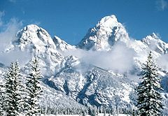
| 2 | Grand Teton Grand Teton Grand Teton is the highest mountain in Wyoming's Grand Teton National Park, and a classic destination in American mountaineering.- Geography :... |
13770 ft (4,197 m) | Teton Range Teton Range The Teton Range is a mountain range of the Rocky Mountains in North America. A north-south range, it is on the Wyoming side of the state's border with Idaho, just south of Yellowstone National Park. Most of the range is in Grand Teton National Park.... |
| 3 | Fremont Peak Fremont Peak (Wyoming) Fremont Peak is the third highest peak in Wyoming and straddles the boundary between Fremont and Sublette counties. It is named for American explorer John C. Fremont who climbed the peak with Charles Preuss and Johnny Janisse on August 13 to August 15, 1842... |
13745 ft (4,189 m) | Wind River Range Wind River Range The Wind River Range , is a mountain range of the Rocky Mountains in western Wyoming in the United States. The range runs roughly NW-SE for approximately 100 miles . The Continental Divide follows the crest of the range and includes Gannett Peak, which at 13,804 feet , is the highest peak... |
| 4 | Mount Warren Mount Warren Mount Warren is located in the Wind River Range in the U.S. state of Wyoming. Mount Warren is the third highest peak in the range and the fourth in the state. The summit is located in the Fitzpatrick Wilderness of Shoshone National Forest and rises above several glaciers, the best known being... |
13722 ft (4,182 m) | Wind River Range Wind River Range The Wind River Range , is a mountain range of the Rocky Mountains in western Wyoming in the United States. The range runs roughly NW-SE for approximately 100 miles . The Continental Divide follows the crest of the range and includes Gannett Peak, which at 13,804 feet , is the highest peak... |
| 5 | Mount Helen | 13620 ft (4,151 m) | Wind River Range Wind River Range The Wind River Range , is a mountain range of the Rocky Mountains in western Wyoming in the United States. The range runs roughly NW-SE for approximately 100 miles . The Continental Divide follows the crest of the range and includes Gannett Peak, which at 13,804 feet , is the highest peak... |
| 6 | Turret Peak Turret Peak (Wyoming) Turret Peak is the sixth highest peak in Wyoming and the fifth highest in the Wind River Range. The Dinwoody Glacier is located on the northwest slope of the mountain. Turret Peak is estimated to be between and high.... |
13620 ft (4,151 m) | Wind River Range Wind River Range The Wind River Range , is a mountain range of the Rocky Mountains in western Wyoming in the United States. The range runs roughly NW-SE for approximately 100 miles . The Continental Divide follows the crest of the range and includes Gannett Peak, which at 13,804 feet , is the highest peak... |
| 7 | Mount Sacagawea Mount Sacagawea Mount Sacagawea is the seventh highest peak in Wyoming and the sixth highest in the Wind River Range. It was named after Sacagawea, the female Shoshone who accompanied the Lewis and Clark Expedition. The Upper Fremont Glacier is located southeast and the Sacagawea Glacier is northeast of the mountain... |
13569 ft (4,136 m) | Wind River Range Wind River Range The Wind River Range , is a mountain range of the Rocky Mountains in western Wyoming in the United States. The range runs roughly NW-SE for approximately 100 miles . The Continental Divide follows the crest of the range and includes Gannett Peak, which at 13,804 feet , is the highest peak... |
| 8 | Jackson Peak Jackson Peak (Fremont County, Wyoming) Jackson Peak is the eighth highest peak in Wyoming and the seventh highest in the Wind River Range. The Bull Lake Glacier is located immediately north and east of the mountain. Situated on the Continental Divide, Jackson Peak is southeast of Fremont Peak.... |
13517 ft (4,120 m) | Wind River Range Wind River Range The Wind River Range , is a mountain range of the Rocky Mountains in western Wyoming in the United States. The range runs roughly NW-SE for approximately 100 miles . The Continental Divide follows the crest of the range and includes Gannett Peak, which at 13,804 feet , is the highest peak... |
| 9 | Mount Woodrow Wilson Mount Woodrow Wilson Mount Woodrow Wilson is located in the Wind River Range in the U.S. state of Wyoming. The peak is the eighth highest in the range and the ninth highest in Wyoming. The summit is located in the Bridger Wilderness of Bridger-Teton National Forest, immediately west of the Continental Divide... |
13502 ft (4,115 m) | Wind River Range Wind River Range The Wind River Range , is a mountain range of the Rocky Mountains in western Wyoming in the United States. The range runs roughly NW-SE for approximately 100 miles . The Continental Divide follows the crest of the range and includes Gannett Peak, which at 13,804 feet , is the highest peak... |
| 10 | Bastion Peak Bastion Peak Bastion Peak is located in the Wind River Range in the U.S. state of Wyoming. The peak is the ninth highest in the range and the tenth highest in Wyoming. The summit is located on the Continental Divide and the eastern slopes of the mountain are covered by a section of Gannett Glacier, the... |
13494 ft (4,113 m) | Wind River Range Wind River Range The Wind River Range , is a mountain range of the Rocky Mountains in western Wyoming in the United States. The range runs roughly NW-SE for approximately 100 miles . The Continental Divide follows the crest of the range and includes Gannett Peak, which at 13,804 feet , is the highest peak... |
Other notable Wyoming thirteeners include:
| Rank | Mountain | Elevation | Range |
|---|---|---|---|
| 20 | Wind River Peak Wind River Peak Wind River Peak is the highest point in the southern end of the Wind River Range that is located in the U.S. state of Wyoming. The peak straddles the Continental Divide and is surrounded by National Forest lands... |
13192 ft (4,021 m) | Wind River Range Wind River Range The Wind River Range , is a mountain range of the Rocky Mountains in western Wyoming in the United States. The range runs roughly NW-SE for approximately 100 miles . The Continental Divide follows the crest of the range and includes Gannett Peak, which at 13,804 feet , is the highest peak... |
| 23 | Cloud Peak Cloud Peak Cloud Peak is the highest peak within the Big Horn Mountains in the U.S. state of Wyoming. It rises to an elevation of and provides onlookers with dramatic views and vistas. The mountain can be climbed most easily from the western side. The peak is located in the 189,000 acre Cloud Peak... |
13167 ft (4,013 m) | Big Horn Mountains Big Horn Mountains The Big Horn Mountains are a mountain range in northern Wyoming and southern Montana in the United States, forming a northwest-trending spur from the Rocky Mountains extending approximately 200 miles northward on the Great Plains... |
| 26 | Francs Peak Francs Peak Francs Peak is the highest point in the Absaroka Range which extends from north central Wyoming into south central Montana, in the United States. Located in the Washakie Wilderness of Shoshone National Forest, the peak is a relatively easy climb which can be achieved in less than a day... |
13153 ft (4,009 m) | Absaroka Range Absaroka Range The Absaroka Range is a sub-range of the Rocky Mountains in the United States. The range stretches about 150 mi across the Montana-Wyoming border, forming the eastern boundary of Yellowstone National Park and the western side of the Bighorn Basin. The range borders the Beartooth Mountains... |
| 33 | Black Tooth Mountain Black Tooth Mountain Black Tooth Mountain is located in the Bighorn Mountains in the U.S. state of Wyoming. The peak is the second highest in the range after Cloud Peak. The summit is located in the Cloud Peak Wilderness of Bighorn National Forest. The sharp profile of the mountain gives it the name Black Tooth... |
13005 ft (3,964 m) | Big Horn Mountains Big Horn Mountains The Big Horn Mountains are a mountain range in northern Wyoming and southern Montana in the United States, forming a northwest-trending spur from the Rocky Mountains extending approximately 200 miles northward on the Great Plains... |
Utah
UtahUtah
Utah is a state in the Western United States. It was the 45th state to join the Union, on January 4, 1896. Approximately 80% of Utah's 2,763,885 people live along the Wasatch Front, centering on Salt Lake City. This leaves vast expanses of the state nearly uninhabited, making the population the...
has 17 thirteeners with at least 300 ft of prominence, but no fourteeners. All of them are located in the remote Uinta Mountains
Uinta Mountains
The Uinta Mountains are a high chain of mountains in northeastern Utah and extreme northwestern Colorado in the United States. A subrange of the Rocky Mountains, they are unusual for being the highest range in the contiguous United States running east to west, and lie approximately east of Salt...
near the Wyoming border, with none in the more famous Wasatch Range
Wasatch Range
The Wasatch Range is a mountain range that stretches approximately from the Utah-Idaho border, south through central Utah in the western United States. It is generally considered the western edge of the greater Rocky Mountains, and the eastern edge of the Great Basin region...
. Only nine of these thirteeners even have official names, the others (including those ranked 5–9) are merely unnamed sub-peaks with sufficient prominence to qualify. The highest of the thirteeners are:
| Rank | Mountain | Elevation | Range |
|---|---|---|---|
| 1 | Kings Peak Kings Peak For the mountain in Idaho, see Kings Peak .Kings Peak is the highest peak in the U.S. state of Utah,with an elevation of . It lies just south of the spine of the central Uinta Mountains, in the Ashley National Forest in northeastern Utah, in north-central Duchesne County. It is also located in the... |
13528 ft (4,123 m) | Uinta Mountains Uinta Mountains The Uinta Mountains are a high chain of mountains in northeastern Utah and extreme northwestern Colorado in the United States. A subrange of the Rocky Mountains, they are unusual for being the highest range in the contiguous United States running east to west, and lie approximately east of Salt... |
| 2 | South Kings Peak Kings Peak For the mountain in Idaho, see Kings Peak .Kings Peak is the highest peak in the U.S. state of Utah,with an elevation of . It lies just south of the spine of the central Uinta Mountains, in the Ashley National Forest in northeastern Utah, in north-central Duchesne County. It is also located in the... |
13512 ft (4,118 m) | Uinta Mountains Uinta Mountains The Uinta Mountains are a high chain of mountains in northeastern Utah and extreme northwestern Colorado in the United States. A subrange of the Rocky Mountains, they are unusual for being the highest range in the contiguous United States running east to west, and lie approximately east of Salt... |
| 3 | Gilbert Peak | 13442 ft (4,097 m) | Uinta Mountains Uinta Mountains The Uinta Mountains are a high chain of mountains in northeastern Utah and extreme northwestern Colorado in the United States. A subrange of the Rocky Mountains, they are unusual for being the highest range in the contiguous United States running east to west, and lie approximately east of Salt... |
| 4 | Mount Emmons | 13440 ft (4,097 m) | Uinta Mountains Uinta Mountains The Uinta Mountains are a high chain of mountains in northeastern Utah and extreme northwestern Colorado in the United States. A subrange of the Rocky Mountains, they are unusual for being the highest range in the contiguous United States running east to west, and lie approximately east of Salt... |
New Mexico
New MexicoNew Mexico
New Mexico is a state located in the southwest and western regions of the United States. New Mexico is also usually considered one of the Mountain States. With a population density of 16 per square mile, New Mexico is the sixth-most sparsely inhabited U.S...
has 3 thirteeners, all located within about 40 miles (64 km) of each other in the Sangre de Cristo Mountains
Sangre de Cristo Mountains
The Sangre de Cristo Mountains are the southernmost subrange of the Rocky Mountains. They are located in southern Colorado and northern New Mexico in the United States...
.
| Rank | Mountain | Elevation | Range |
|---|---|---|---|
| 1 | Wheeler Peak Wheeler Peak (New Mexico) Wheeler Peak is, at 13,161 ft, the highest peak in the U.S. state of New Mexico. It is located northeast of Taos in the northern part of the state, and just 2 miles southeast of the ski slopes of Taos Ski Valley... |
13161 ft (4,011 m) | Sangre de Cristo Mountains Sangre de Cristo Mountains The Sangre de Cristo Mountains are the southernmost subrange of the Rocky Mountains. They are located in southern Colorado and northern New Mexico in the United States... |
| 2 | Truchas Peak Truchas Peak Truchas Peak is the second highest independent peak in the US State of New Mexico. It is in the Sangre de Cristo Mountains 26 mi northeast of Santa Fe. It lies within the Pecos Wilderness, part of the Santa Fe National Forest... |
13102 ft (3,993 m) | Sangre de Cristo Mountains Sangre de Cristo Mountains The Sangre de Cristo Mountains are the southernmost subrange of the Rocky Mountains. They are located in southern Colorado and northern New Mexico in the United States... |
| 3 | North Truchas Peak Truchas Peak Truchas Peak is the second highest independent peak in the US State of New Mexico. It is in the Sangre de Cristo Mountains 26 mi northeast of Santa Fe. It lies within the Pecos Wilderness, part of the Santa Fe National Forest... |
13024 ft (3,970 m) | Sangre de Cristo Mountains Sangre de Cristo Mountains The Sangre de Cristo Mountains are the southernmost subrange of the Rocky Mountains. They are located in southern Colorado and northern New Mexico in the United States... |
Hawaii
HawaiiHawaii
Hawaii is the newest of the 50 U.S. states , and is the only U.S. state made up entirely of islands. It is the northernmost island group in Polynesia, occupying most of an archipelago in the central Pacific Ocean, southwest of the continental United States, southeast of Japan, and northeast of...
has two thirteeners, the great shield volcanoes which comprise the bulk of the Big Island of Hawaii
Hawaii (island)
The Island of Hawaii, also called the Big Island or Hawaii Island , is a volcanic island in the North Pacific Ocean...
.
| Rank | Mountain | Elevation | Range |
|---|---|---|---|
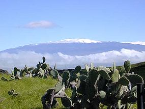
| 1 | Mauna Kea Mauna Kea Mauna Kea is a volcano on the island of Hawaii. Standing above sea level, its peak is the highest point in the state of Hawaii. However, much of the mountain is under water; when measured from its oceanic base, Mauna Kea is over tall—significantly taller than Mount Everest... |
13796 ft (4,205 m) | Island of Hawaii Hawaii (island) The Island of Hawaii, also called the Big Island or Hawaii Island , is a volcanic island in the North Pacific Ocean... |
| 2 | Mauna Loa Mauna Loa Mauna Loa is one of five volcanoes that form the Island of Hawaii in the U.S. state of Hawaii in the Pacific Ocean, and the largest on Earth in terms of volume and area covered. It is an active shield volcano, with a volume estimated at approximately , although its peak is about lower than that... |
13680 ft (4,170 m) | Island of Hawaii Hawaii (island) The Island of Hawaii, also called the Big Island or Hawaii Island , is a volcanic island in the North Pacific Ocean... |
Nevada
NevadaNevada
Nevada is a state in the western, mountain west, and southwestern regions of the United States. With an area of and a population of about 2.7 million, it is the 7th-largest and 35th-most populous state. Over two-thirds of Nevada's people live in the Las Vegas metropolitan area, which contains its...
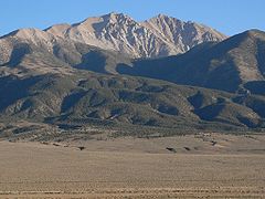
has only a single thirteener that meets the threshold for inclusion, Wheeler Peak
Wheeler Peak (Nevada)
Wheeler Peak, elevation , a mountain in the Great Basin Desert, is the highest point in Great Basin National Park. The summit is located west of the Utah border...
in Great Basin National Park
Great Basin National Park
Great Basin National Park is a United States National Park established in 1986, located in east-central Nevada near the Utah border. The park derives its name from the Great Basin, the dry and mountainous region between the Sierra Nevada and the Wasatch Mountains. Topographically, this area is...
with an impressive 7568 feet (2,307 m) of prominence. However, the highest point in the state is Boundary Peak
Boundary Peak (Nevada)
Boundary Peak is the highest summit in U. S. state of Nevada and is located in Esmeralda County. It is the northernmost peak over 13,000 feet in the White Mountains. At the peak is within the state of Nevada, although it is only about half a mile from the California border...
, which is a sub-peak of California's Montgomery Peak
Montgomery Peak
Montgomery Peak is a mountain in the White Mountains of California, USA. It is less than from Boundary Peak, the highest point in Nevada. It can be climbed in combination with Boundary Peak....
with only 240 feet (73 m) of prominence.
| Mountain | Elevation | Range |
|---|---|---|
| Boundary Peak Boundary Peak (Nevada) Boundary Peak is the highest summit in U. S. state of Nevada and is located in Esmeralda County. It is the northernmost peak over 13,000 feet in the White Mountains. At the peak is within the state of Nevada, although it is only about half a mile from the California border... |
13140 ft (4,005 m) | White Mountains White Mountains (California) The White Mountains of California are a triangular fault block mountain range facing the Sierra Nevada across the upper Owens Valley. They extend for approximately as a greatly elevated plateau about wide on the south, narrowing to a point at the north, with elevations generally increasing... |
| Wheeler Peak Wheeler Peak (Nevada) Wheeler Peak, elevation , a mountain in the Great Basin Desert, is the highest point in Great Basin National Park. The summit is located west of the Utah border... |
13065 ft (3,982 m) | Snake Range Snake Range The Snake Range is a line of high mountains in eastern White Pine County, in east-central Nevada in the western United States. Typical of other ranges in the Basin and Range Province, it runs in a north-south direction, in this case for approximately... |
Washington
Mount RainierMount Rainier
Mount Rainier is a massive stratovolcano located southeast of Seattle in the state of Washington, United States. It is the most topographically prominent mountain in the contiguous United States and the Cascade Volcanic Arc, with a summit elevation of . Mt. Rainier is considered one of the most...
is the only mountain in Washington state that exceeds 13000 feet (3,962.4 m), and it has two summits that meet the prominence criteria, both of which are included on the list of fourteener
Fourteener
In mountaineering terminology in the United States, a fourteener is a mountain that exceeds 14,000 feet above mean sea level. There are 547 fourteeners in the world. The importance of fourteeners is greatest in Colorado, which has the majority of such peaks in North America...
s.
See also
- FourteenerFourteenerIn mountaineering terminology in the United States, a fourteener is a mountain that exceeds 14,000 feet above mean sea level. There are 547 fourteeners in the world. The importance of fourteeners is greatest in Colorado, which has the majority of such peaks in North America...
- Mountain peaks of AlaskaMountain peaks of AlaskaThis article comprises three sortable tables of mountain peaks of the U.S. State of Alaska.Topographic elevation is the vertical distance above the reference geoid, a precise mathematical model of the Earth's sea level as an equipotential gravitational surface. Topographic prominence is the...
- Mountain peaks of CaliforniaMountain peaks of CaliforniaThis article comprises three sortable tables of major mountain peaks of the U.S. State of California.Topographic elevation is the vertical distance above the reference geoid, a precise mathematical model of the Earth's sea level as an equipotential gravitational surface...
- Mountain peaks of ColoradoMountain peaks of ColoradoThis article comprises three sortable tables of the major mountain peaks of the U.S. State of Colorado.Topographic elevation is the vertical distance above the reference geoid, a precise mathematical model of the Earth's sea level as an equipotential gravitational surface...
- Mountain peaks of the Rocky MountainsMountain peaks of the Rocky MountainsThis article comprises three sortable tables of major mountain peaks of the Rocky Mountains of North America.Topographic elevation is the vertical distance above the reference geoid, a precise mathematical model of the Earth's sea level as an equipotential gravitational surface...
- Mountain peaks of the United StatesMountain peaks of the United StatesThis article comprises three sortable tables of the major mountain peaks of the United States of America.Topographic elevation is the vertical distance above the reference geoid, a precise mathematical model of the Earth's sea level as an equipotential gravitational surface...
External links
- Peak Lists by Gerry Roach (Lists of thirteeners in several states)
- 13ers.com - Home of Colorado's Thirteeners (Mountains Between 13,000 and 14,000 feet)
- California Thirteeners: The Official Vulgarian Ramblers List (with interactive maps)
- Peak Lists - Peakbagger.com (Lists of thirteeners in several states)
- Peaklist.org (More prominence information for high-prominence peaks)