
Sangre de Cristo Mountains
Encyclopedia
The Sangre de Cristo Mountains (Spanish
for "Blood of Christ
") are the southernmost subrange
of the Rocky Mountains
. They are located in southern Colorado
and northern New Mexico
in the United States
. The mountains run from Poncha Pass
in South-Central Colorado
, trending southeast and south, ending at Glorieta Pass
, southeast of Santa Fe, New Mexico
.
The mountains contain a number of fourteen thousand foot peaks in the Colorado portion, as well as all the peaks in New Mexico which are over thirteen thousand feet.
The name, Spanish
for "blood of Christ", is said to come from the red color of the range at some sunrises and sunsets, especially when the mountains are covered with snow, alpenglow
. However the particular origin of the name is unclear, and the name in fact only dates back to the early 19th century. Before that time the terms "La Sierra Nevada", "La Sierra Madre", "La Sierra", and "The Snowies" (used by English speakers) were used. Sometimes the archaic Spanish spelling "Christo" is used.
and San Isabel
in Colorado, and the Carson
and Santa Fe
in New Mexico. These publicly accessible areas are popular for hunting
, camping
, hiking
, backpacking
, climbing
, and cross-country
and downhill skiing.
The mountains include two large wilderness areas, the Sangre de Cristo Wilderness
in Colorado and the Pecos Wilderness
in New Mexico, as well as some smaller wilderness areas, such as Latir Peak Wilderness
. The Great Sand Dunes National Park and Preserve
lies on the southwest side of the mountains in Colorado.
Spanish language
Spanish , also known as Castilian , is a Romance language in the Ibero-Romance group that evolved from several languages and dialects in central-northern Iberia around the 9th century and gradually spread with the expansion of the Kingdom of Castile into central and southern Iberia during the...
for "Blood of Christ
Blood of Christ
The Blood of Christ in Christian theology refers to the physical blood actually shed by Jesus Christ on the Cross, and the salvation which Christianity teaches was accomplished thereby; and the sacramental blood present in the Eucharist, which is considered by Catholic, Orthodox, Anglican, and...
") are the southernmost subrange
Mountain range
A mountain range is a single, large mass consisting of a succession of mountains or narrowly spaced mountain ridges, with or without peaks, closely related in position, direction, formation, and age; a component part of a mountain system or of a mountain chain...
of the Rocky Mountains
Rocky Mountains
The Rocky Mountains are a major mountain range in western North America. The Rocky Mountains stretch more than from the northernmost part of British Columbia, in western Canada, to New Mexico, in the southwestern United States...
. They are located in southern Colorado
Colorado
Colorado is a U.S. state that encompasses much of the Rocky Mountains as well as the northeastern portion of the Colorado Plateau and the western edge of the Great Plains...
and northern New Mexico
New Mexico
New Mexico is a state located in the southwest and western regions of the United States. New Mexico is also usually considered one of the Mountain States. With a population density of 16 per square mile, New Mexico is the sixth-most sparsely inhabited U.S...
in the United States
United States
The United States of America is a federal constitutional republic comprising fifty states and a federal district...
. The mountains run from Poncha Pass
Poncha Pass
Poncha Pass is a mountain pass in South-Central Colorado . It lies between the San Luis Valley to the south and the valley of the Arkansas River to the north, and is one of the lowest mountain passes in the state . It is in the saddle between the Sangre de Cristo Range, lying to the southeast, and...
in South-Central Colorado
South-Central Colorado
South-Central Colorado is a region of the U.S. state of Colorado. It can be roughly defined by Chaffee County in the northwest, El Paso County in the northeast, Las Animas County in the southeast, and Conejos County in the southwest. Some notable towns there include Colorado Springs, Pueblo,...
, trending southeast and south, ending at Glorieta Pass
Glorieta Pass
Glorieta Pass is a high mountain pass in the Sangre de Cristo Mountains of northern New Mexico. The pass is at a strategic location near at the southern end of the Sangre de Cristos in east central Santa Fe County southeast of the city of Santa Fe.Historically, the pass provided the most direct...
, southeast of Santa Fe, New Mexico
Santa Fe, New Mexico
Santa Fe is the capital of the U.S. state of New Mexico. It is the fourth-largest city in the state and is the seat of . Santa Fe had a population of 67,947 in the 2010 census...
.
The mountains contain a number of fourteen thousand foot peaks in the Colorado portion, as well as all the peaks in New Mexico which are over thirteen thousand feet.
The name, Spanish
Spanish language
Spanish , also known as Castilian , is a Romance language in the Ibero-Romance group that evolved from several languages and dialects in central-northern Iberia around the 9th century and gradually spread with the expansion of the Kingdom of Castile into central and southern Iberia during the...
for "blood of Christ", is said to come from the red color of the range at some sunrises and sunsets, especially when the mountains are covered with snow, alpenglow
Alpenglow
Alpenglow is an optical phenomenon. When the Sun is just below the horizon, a horizontal red glowing band can sometimes be observed on the opposite horizon...
. However the particular origin of the name is unclear, and the name in fact only dates back to the early 19th century. Before that time the terms "La Sierra Nevada", "La Sierra Madre", "La Sierra", and "The Snowies" (used by English speakers) were used. Sometimes the archaic Spanish spelling "Christo" is used.
Land management and recreation overview
Much of the mountains are within various National Forests: the Rio GrandeRio Grande National Forest
Rio Grande National Forest is a 1.86 million acre U.S. National Forest located in southwestern Colorado. The forest encompasses the San Luis Valley, which is the world's largest agricultural alpine valley, as well as one of the worlds largest high deserts located around mountains. The...
and San Isabel
San Isabel National Forest
San Isabel National Forest is located in central Colorado. The forest contains 19 of the state's 54 fourteeners, peaks over high, including Mount Elbert, the highest point in Colorado....
in Colorado, and the Carson
Carson National Forest
Carson National Forest is a national forest in northern New Mexico, United States. It encompasses 6,070 square kilometers and is administered by the United States Forest Service...
and Santa Fe
Santa Fe National Forest
The Santa Fe National Forest is a protected national forest in northern New Mexico in the Southwestern United States. It was established in 1915 and covers 1,567,181 acres . Elevations range from 5,300 feet to 13,103 feet at the summit of Truchas Peak, located within the Pecos Wilderness...
in New Mexico. These publicly accessible areas are popular for hunting
Hunting
Hunting is the practice of pursuing any living thing, usually wildlife, for food, recreation, or trade. In present-day use, the term refers to lawful hunting, as distinguished from poaching, which is the killing, trapping or capture of the hunted species contrary to applicable law...
, camping
Camping
Camping is an outdoor recreational activity. The participants leave urban areas, their home region, or civilization and enjoy nature while spending one or several nights outdoors, usually at a campsite. Camping may involve the use of a tent, caravan, motorhome, cabin, a primitive structure, or no...
, hiking
Hiking
Hiking is an outdoor activity which consists of walking in natural environments, often in mountainous or other scenic terrain. People often hike on hiking trails. It is such a popular activity that there are numerous hiking organizations worldwide. The health benefits of different types of hiking...
, backpacking
Backpacking (wilderness)
Backpacking combines the activities of hiking and camping for an overnight stay in backcountry wilderness...
, climbing
Rock climbing
Rock climbing also lightly called 'The Gravity Game', is a sport in which participants climb up, down or across natural rock formations or artificial rock walls. The goal is to reach the summit of a formation or the endpoint of a pre-defined route without falling...
, and cross-country
Cross-country skiing
Cross-country skiing is a winter sport in which participants propel themselves across snow-covered terrain using skis and poles...
and downhill skiing.
The mountains include two large wilderness areas, the Sangre de Cristo Wilderness
Sangre de Cristo Wilderness
The Sangre de Cristo Wilderness is a long and narrow wilderness area covering much of the Sangre de Cristo Range centered about Saguache County and Custer County, Colorado. Smaller areas are located in the counties of Fremont, Alamosa, and Huerfano. All of the wilderness area is located on U.S...
in Colorado and the Pecos Wilderness
Pecos Wilderness
The Pecos Wilderness is a protected wilderness area within the Santa Fe National Forest and Carson National Forest. The Pecos Wilderness is in the Sangre de Cristo Mountains of north central New Mexico, easily accessible from Santa Fe, the state capital. Covering an area of , it is the second...
in New Mexico, as well as some smaller wilderness areas, such as Latir Peak Wilderness
Latir Peak Wilderness
Latir Peak Wilderness is a wilderness area located within the Carson National Forest in northern New Mexico, USA. Designated in 1980, the Wilderness is composed of dense forest, meadows, and alpine tundra on Latir Mesa in the northern portion...
. The Great Sand Dunes National Park and Preserve
Great Sand Dunes National Park and Preserve
-Other features:The park also contains alpine lakes and tundra, six peaks over 13,000 feet in elevation, ancient spruce and pine forests, large stands of aspen and cottonwood, grasslands, and wetlands — all habitat for diverse wildlife and plant species.One of the most unusual features of...
lies on the southwest side of the mountains in Colorado.
Prominent peaks and subranges
The Sangre de Cristo Mountains are divided into various subranges, described here from north to south. Use of the terms "Sangre de Cristo Range" and "Sangre de Cristo Mountains" is inconsistent and either may refer to either the northernmost subrange, the southernmost subrange, or the mountains as a whole.| Rank Ranking A ranking is a relationship between a set of items such that, for any two items, the first is either 'ranked higher than', 'ranked lower than' or 'ranked equal to' the second.... |
Mountain Peak Summit (topography) In topography, a summit is a point on a surface that is higher in elevation than all points immediately adjacent to it. Mathematically, a summit is a local maximum in elevation... |
Subrange Mountain range A mountain range is a single, large mass consisting of a succession of mountains or narrowly spaced mountain ridges, with or without peaks, closely related in position, direction, formation, and age; a component part of a mountain system or of a mountain chain... |
Elevation | Prominence Topographic prominence In topography, prominence, also known as autonomous height, relative height, shoulder drop , or prime factor , categorizes the height of the mountain's or hill's summit by the elevation between it and the lowest contour line encircling it and no higher summit... |
Isolation Topographic isolation The topographic isolation of a summit is the minimum horizontal distance to the nearest point of higher elevation. Topographic isolation represents a radius of dominance in which the summit is the highest point. Topographic isolation can be calculated for small hills and islands as well as for... |
Image | Comment |
|---|---|---|---|---|---|---|---|
| 1 | Blanca Peak Blanca Peak Blanca Peak is the highest peak of the Sierra Blanca Massif at the southern tip of the Sangre de Cristo Mountains in the U.S. State of Colorado. It is the fourth highest peak of the Rocky Mountains, and the eighth highest peak in the contiguous United States.... |
Sierra Blanca |
Blanca Peak in Colorado is the highest peak of the Sangre de Cristo mountains. | ||||
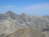
| 2 | Crestone Peak Crestone Peak Crestone Peak is the seventh highest peak in the U.S. state of Colorado. It is the second highest peak in the Sangre de Cristo Range after Blanca Peak. It rises in the Sangre de Cristo Wilderness above the east side of the San Luis Valley along the boundary between Saguache and Custer counties,... |
Crestones Crestones The Crestones are a group of four 14,000 foot peaks in the Sangre de Cristo Range above Crestone, Colorado, comprising:*Crestone Peak *Crestone Needle *Kit Carson Mountain... |
 |
The Crestones are a group of four 14,000 foot (4,268 m) peaks (fourteeners) in the Sangre de Cristo Range Sangre de Cristo Range The Sangre de Cristo Range, called the East Range locally in the San Luis Valley, is a narrow mountain range of the Rocky Mountains running north and south along the east side of the Rio Grande Rift in southern Colorado in the United States... above Crestone, Colorado Crestone, Colorado Crestone is a statutory town in Saguache County in Southwestern Colorado, United States. The population was 73 at the 2000 census. It is a small village at the foot of the western slope of the Sangre de Cristo Range, in the northern part of the San Luis Valley. Crestone was a small mining town, but... . Crestone Peak is rock scramble Scramble Scramble may refer to:* Scramble , a 1981 arcade game* Scramble , an enemy of the Marvel Comics Canadian superhero team Alpha Flight* Scramble , a 1970 British drama film... s (Class 3) with some exposure and significant rockfall Rockfall Rockfall or rock-fall refers to quantities of rock falling freely from a cliff face. A rockfall is a fragment of rock detached by sliding, toppling, or falling, that falls along a vertical or sub-vertical cliff, proceeds down slope by bouncing and flying along ballistic trajectories or by rolling... danger. (Image: Crestone Peak and Crestone Needle seen from the south) |
|||
| 3 | Culebra Peak Culebra Peak Culebra Peak is the highest peak of the Culebra Range, a subrange of the Sangre de Cristo Mountains in the United States. It is the southernmost fourteener in Colorado. It is also the only fourteener on private land. Access is limited, and a fee is charged to climb the peak... |
Culebra Range |
The Culebra Range runs almost due north and south, with its northern limit at La Veta Pass in Colorado, and its southern limit at Costilla Creek, just south of Big Costilla Peak in New Mexico. Its highest point is Culebra Peak Culebra Peak Culebra Peak is the highest peak of the Culebra Range, a subrange of the Sangre de Cristo Mountains in the United States. It is the southernmost fourteener in Colorado. It is also the only fourteener on private land. Access is limited, and a fee is charged to climb the peak... (14,047 feet/4,282 m), which is notable for being the only fourteener Fourteener In mountaineering terminology in the United States, a fourteener is a mountain that exceeds 14,000 feet above mean sea level. There are 547 fourteeners in the world. The importance of fourteeners is greatest in Colorado, which has the majority of such peaks in North America... in Colorado which is on private land. (Image: Big Costilla Peak in the Culebra Range, viewed from Valle Vidal Valle Vidal The Valle Vidal is a 100,000-acre area in the Sangre de Cristo Mountains within the Carson National Forest, northwest of Cimarron, New Mexico. Pennzoil donated the Valle Vidal to the American public in 1982. Valle Vidal hosts a number of species of animals including elk, black bear, turkey,... .) |
||||
| 4 | West Spanish Peak West Spanish Peak West Spanish Peak is a high mountain peak in the US state of Colorado. It is the higher of the two Spanish Peaks, two large igneous stocks which form an eastern outlier of the Culebra Range, a subrange of the Sangre de Cristo Mountains... |
Spanish Peaks Spanish Peaks The Spanish Peaks are a pair of volcanic mountains located in southwestern Huerfano County, Colorado. The Ute indians named them Huajatolla , meaning "two breasts". The Spanish name translates as "Breasts of the Earth". The two peaks, West Spanish Peak and East Spanish Peak, are the easternmost... |
The Spanish Peaks are a pair of volcanic mountains, West Spanish Peak West Spanish Peak West Spanish Peak is a high mountain peak in the US state of Colorado. It is the higher of the two Spanish Peaks, two large igneous stocks which form an eastern outlier of the Culebra Range, a subrange of the Sangre de Cristo Mountains... and East Spanish Peak East Spanish Peak East Spanish Peak is a high mountain peak in the US state of Colorado. It is the lower of the two Spanish Peaks, two large igneous stocks which form an eastern outlier of the Culebra Range, a subrange of the Sangre de Cristo Mountains.- Geology :... , located in southwestern Huerfano County Huerfano County, Colorado Huerfano County is one of the 64 counties of the State of Colorado of the United States. The county was named for the Huerfano Butte, a local landmark. The county population was 7,862 at U.S. Census 2000... , Colorado Colorado Colorado is a U.S. state that encompasses much of the Rocky Mountains as well as the northeastern portion of the Colorado Plateau and the western edge of the Great Plains... ., the Spanish Peaks were designated a National Natural Landmark National Natural Landmark The National Natural Landmark program recognizes and encourages the conservation of outstanding examples of the natural history of the United States. It is the only natural areas program of national scope that identifies and recognizes the best examples of biological and geological features in... in 1976 as one of the best known examples of igneous dikes Dike (geology) A dike or dyke in geology is a type of sheet intrusion referring to any geologic body that cuts discordantly across* planar wall rock structures, such as bedding or foliation... . The mountains can be seen as far north as Colorado Springs (133 miles), as far west as Alamosa Alamosa, Colorado The city of Alamosa is a Home Rule Municipality that is the county seat and the most populous city of Alamosa County, Colorado, United States. The United States Census Bureau estimates that the city population was 8,682 in 2005... (85 miles), points south to Raton, New Mexico Raton, New Mexico Raton is a city in Colfax County, New Mexico, United States. The population was 7,282 at the 2000 census. It is the county seat of Colfax County. The city is located just south of Raton Pass.-Name:... (65 miles), and points east of Trinidad (up to 15 miles). (Image: West Spanish Peak taken from the south) |
||||
| 5 | Mount Herard | Sangre de Cristo Range Sangre de Cristo Range The Sangre de Cristo Range, called the East Range locally in the San Luis Valley, is a narrow mountain range of the Rocky Mountains running north and south along the east side of the Rio Grande Rift in southern Colorado in the United States... |
The Sangre de Cristo Range Sangre de Cristo Range The Sangre de Cristo Range, called the East Range locally in the San Luis Valley, is a narrow mountain range of the Rocky Mountains running north and south along the east side of the Rio Grande Rift in southern Colorado in the United States... , the largest and most northerly subrange of the Sangre de Cristo Mountains, runs directly along the east side of the Rio Grande Rift Rio Grande Rift The Rio Grande Rift is a north-trending continental rift zone. It separates the Colorado Plateau in the west from the interior of the North American craton on the east. The rift extends from central Colorado in the north to the state of Chihuahua, Mexico in the south. The rift zone consists of four... , extending southeast from Poncha Pass Poncha Pass Poncha Pass is a mountain pass in South-Central Colorado . It lies between the San Luis Valley to the south and the valley of the Arkansas River to the north, and is one of the lowest mountain passes in the state . It is in the saddle between the Sangre de Cristo Range, lying to the southeast, and... for about 75 miles (120 km) through south-central Colorado to La Veta Pass, approximately 20 miles (32 km) west of Walsenburg Walsenburg, Colorado The City of Walsenburg or Los Leones is a Statutory City that is the county seat and the most populous city of Huerfano County, Colorado, United States... . They form a high ridge separating the San Luis Valley San Luis Valley The San Luis Valley is an extensive alpine valley in the U.S. states of Colorado and New Mexico covering approximately and sitting at an average elevation of above sea level. The valley sits atop the Rio Grande Rift and is drained to the south by the Rio Grande River, which rises in the San Juan... on the west from the watershed of the Arkansas River Arkansas River The Arkansas River is a major tributary of the Mississippi River. The Arkansas generally flows to the east and southeast as it traverses the U.S. states of Colorado, Kansas, Oklahoma, and Arkansas. The river's initial basin starts in the Western United States in Colorado, specifically the Arkansas... on the east. (Image: Sangre de Cristo range from the Great Sand Dunes National Park) |
||||
| 6 | Wheeler Peak Wheeler Peak (New Mexico) Wheeler Peak is, at 13,161 ft, the highest peak in the U.S. state of New Mexico. It is located northeast of Taos in the northern part of the state, and just 2 miles southeast of the ski slopes of Taos Ski Valley... |
Taos Mountains |
 |
The Taos Mountains span the western lobe of the range from Costilla Creek in the north, to Tres Ritos in the south. Wheeler Peak Wheeler Peak (New Mexico) Wheeler Peak is, at 13,161 ft, the highest peak in the U.S. state of New Mexico. It is located northeast of Taos in the northern part of the state, and just 2 miles southeast of the ski slopes of Taos Ski Valley... , of the Wheeler Peak Wilderness, is the highest peak in New Mexico. Taos Ski Valley lies just to the west of Wheeler Peak. Much of the central portion of the Taos Mountains are on Taos Pueblo Taos Pueblo Taos Pueblo is an ancient pueblo belonging to a Taos speaking Native American tribe of Pueblo people. It is approximately 1000 years old and lies about north of the modern city of Taos, New Mexico, USA... land. As viewed from Taos Taos, New Mexico Taos is a town in Taos County in the north-central region of New Mexico, incorporated in 1934. As of the 2000 census, its population was 4,700. Other nearby communities include Ranchos de Taos, Cañon, Taos Canyon, Ranchitos, and El Prado. The town is close to Taos Pueblo, the Native American... , they are locally called "Taos Mountain." |
|||
| 7 | Bushnell Peak | Sangre de Cristo Range Sangre de Cristo Range The Sangre de Cristo Range, called the East Range locally in the San Luis Valley, is a narrow mountain range of the Rocky Mountains running north and south along the east side of the Rio Grande Rift in southern Colorado in the United States... |
See #5. Mount Herard | ||||
| 8 | Truchas Peak Truchas Peak Truchas Peak is the second highest independent peak in the US State of New Mexico. It is in the Sangre de Cristo Mountains 26 mi northeast of Santa Fe. It lies within the Pecos Wilderness, part of the Santa Fe National Forest... |
Santa Fe Mountains |
The Santa Fe Mountains include all peaks south of NM Route 518. This group lies near Santa Fe Santa Fe, New Mexico Santa Fe is the capital of the U.S. state of New Mexico. It is the fourth-largest city in the state and is the seat of . Santa Fe had a population of 67,947 in the 2010 census... and surrounds the Pecos Wilderness Pecos Wilderness The Pecos Wilderness is a protected wilderness area within the Santa Fe National Forest and Carson National Forest. The Pecos Wilderness is in the Sangre de Cristo Mountains of north central New Mexico, easily accessible from Santa Fe, the state capital. Covering an area of , it is the second... , which protects the source watershed Drainage basin A drainage basin is an extent or an area of land where surface water from rain and melting snow or ice converges to a single point, usually the exit of the basin, where the waters join another waterbody, such as a river, lake, reservoir, estuary, wetland, sea, or ocean... of the Pecos River Pecos River The headwaters of the Pecos River are located north of Pecos, New Mexico, United States, at an elevation of over 12,000 feet on the western slope of the Sangre de Cristo mountain range in Mora County. The river flows for through the eastern portion of that state and neighboring Texas before it... . Truchas Peak Truchas Peak Truchas Peak is the second highest independent peak in the US State of New Mexico. It is in the Sangre de Cristo Mountains 26 mi northeast of Santa Fe. It lies within the Pecos Wilderness, part of the Santa Fe National Forest... is the highest point in the Santa Fe Mountains. The Pecos Wilderness is crossed by many trails and is popular for backpacking and for fishing in its high alpine lakes. (Image: Truchas Peak in winter from Española, New Mexico) |
||||
| 9 | Venado Peak Venado Peak Venado Peak is one of the major peaks of the Taos Mountains group of the Sangre de Cristo Mountains, a subrange of the Rocky Mountains. It is located in Taos County, New Mexico, about northeast of the town of Questa. It lies in the Latir Peak Wilderness, part of Carson National Forest... |
Taos Mountains |
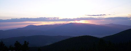
See #6 Wheeler Peak. Aside from Wheeler and Venado peak, other notable peaks include Pueblo Peak (12,305 feet/3,751 m), which rises dramatically above Taos Pueblo Taos Pueblo Taos Pueblo is an ancient pueblo belonging to a Taos speaking Native American tribe of Pueblo people. It is approximately 1000 years old and lies about north of the modern city of Taos, New Mexico, USA... , and Latir Peak (12,708 feet/3,873 m). The southern portion of the Taos Mountains, between Palo Flechado Pass and Tres Ritos (US Route 64 and NM Route 518), is lower and less dramatic than the northern section, with its high point being Cerro Vista, 11939 ft (3,639 m). The Fernando Mountains are a small subrange lying in this section, just south of US Route 64. (Image: Taos Mountain at sunset.) |
||||
| 10 | East Spanish Peak East Spanish Peak East Spanish Peak is a high mountain peak in the US state of Colorado. It is the lower of the two Spanish Peaks, two large igneous stocks which form an eastern outlier of the Culebra Range, a subrange of the Sangre de Cristo Mountains.- Geology :... |
Spanish Peaks Spanish Peaks The Spanish Peaks are a pair of volcanic mountains located in southwestern Huerfano County, Colorado. The Ute indians named them Huajatolla , meaning "two breasts". The Spanish name translates as "Breasts of the Earth". The two peaks, West Spanish Peak and East Spanish Peak, are the easternmost... |
East Spanish Peak is the lower of the two Spanish Peaks Spanish Peaks The Spanish Peaks are a pair of volcanic mountains located in southwestern Huerfano County, Colorado. The Ute indians named them Huajatolla , meaning "two breasts". The Spanish name translates as "Breasts of the Earth". The two peaks, West Spanish Peak and East Spanish Peak, are the easternmost... , two large igneous stock Intrusion An intrusion is liquid rock that forms under Earth's surface. Magma from under the surface is slowly pushed up from deep within the earth into any cracks or spaces it can find, sometimes pushing existing country rock out of the way, a process that can take millions of years. As the rock slowly... s which form an eastern outlier of the Culebra Range, a subrange of the Sangre de Cristo Mountains. (Image: Spanish Peaks as seen from I25, Huerfano county, Colorado) |
||||
| 11 | Santa Fe Baldy Santa Fe Baldy Santa Fe Baldy is a prominent summit in the Sangre de Cristo Mountains of New Mexico, United States, located 15 mi northeast of Santa Fe. There are no higher mountains in New Mexico south of Santa Fe Baldy... |
Santa Fe Mountains |
Santa Fe Baldy is a prominent summit Summit (topography) In topography, a summit is a point on a surface that is higher in elevation than all points immediately adjacent to it. Mathematically, a summit is a local maximum in elevation... in the Sangre de Cristo Mountains of New Mexico New Mexico New Mexico is a state located in the southwest and western regions of the United States. New Mexico is also usually considered one of the Mountain States. With a population density of 16 per square mile, New Mexico is the sixth-most sparsely inhabited U.S... , located 15 mi (24 km) northeast of Santa Fe Santa Fe, New Mexico Santa Fe is the capital of the U.S. state of New Mexico. It is the fourth-largest city in the state and is the seat of . Santa Fe had a population of 67,947 in the 2010 census... . It is prominent as seen from Los Alamos Los Alamos, New Mexico Los Alamos is a townsite and census-designated place in Los Alamos County, New Mexico, United States, built upon four mesas of the Pajarito Plateau and the adjoining White Rock Canyon. The population of the CDP was 12,019 at the 2010 Census. The townsite or "the hill" is one part of town while... and communities along the Rio Grande Rio Grande The Rio Grande is a river that flows from southwestern Colorado in the United States to the Gulf of Mexico. Along the way it forms part of the Mexico – United States border. Its length varies as its course changes... in northern New Mexico, but is relatively inconspicuous from Santa Fe, as its north-south trending main ridge line is seen nearly end-on, disguising the size of the mountain. Santa Fe Baldy lies in the Pecos Wilderness Pecos Wilderness The Pecos Wilderness is a protected wilderness area within the Santa Fe National Forest and Carson National Forest. The Pecos Wilderness is in the Sangre de Cristo Mountains of north central New Mexico, easily accessible from Santa Fe, the state capital. Covering an area of , it is the second... within the Santa Fe National Forest Santa Fe National Forest The Santa Fe National Forest is a protected national forest in northern New Mexico in the Southwestern United States. It was established in 1915 and covers 1,567,181 acres . Elevations range from 5,300 feet to 13,103 feet at the summit of Truchas Peak, located within the Pecos Wilderness... , on the water divide Water divide A drainage divide, water divide, divide or watershed is the line separating neighbouring drainage basins... between the Rio Grande Rio Grande The Rio Grande is a river that flows from southwestern Colorado in the United States to the Gulf of Mexico. Along the way it forms part of the Mexico – United States border. Its length varies as its course changes... and the Pecos River Pecos River The headwaters of the Pecos River are located north of Pecos, New Mexico, United States, at an elevation of over 12,000 feet on the western slope of the Sangre de Cristo mountain range in Mora County. The river flows for through the eastern portion of that state and neighboring Texas before it... . |
||||
| 12 | Baldy Mountain | Cimarron Range |
The Cimarron Range lies across the Moreno Valley to the east of the Taos Mountains. It is a lower range, with its highest point being Baldy Mountain (12,441 feet/3,792 m). The Philmont Scout Ranch Philmont Scout Ranch Philmont Scout Ranch is a large, rugged, mountainous ranch located near the town of Cimarron, New Mexico, covering approximately of wilderness in the Sangre de Cristo Mountains of the Rocky Mountains of northern New Mexico... lies on the east side of the Cimarron Range. {Image: Baldy Peak summit ridge in the Cimarron Range.) |
||||
| 13 | Greenhorn Mountain Greenhorn mountain Greenhorn Mountain is the highest point in the Wet Mountains of southern Colorado and at elevation is just high enough to pass tree line which is about in this part of Colorado. The massive mountain can be seen from Pueblo and all along Interstate 25 rising 6,000 feet above the surrounding area... |
Wet Mountains Wet Mountains The Wet Mountains are a small range of mountains in southern Colorado named for the amount of snow they receive in the winter. There are three variant names of this range: Cuerno Verde, Greenhorn Mountains, and Sierra Mojadas... |
Greenhorn Mountain is the highest point in the Wet Mountains Wet Mountains The Wet Mountains are a small range of mountains in southern Colorado named for the amount of snow they receive in the winter. There are three variant names of this range: Cuerno Verde, Greenhorn Mountains, and Sierra Mojadas... of southern Colorado Colorado Colorado is a U.S. state that encompasses much of the Rocky Mountains as well as the northeastern portion of the Colorado Plateau and the western edge of the Great Plains... , just high enough to pass tree line which is about 11500 feet (3,505.2 m) in this part of Colorado. The massive mountain can be seen from Pueblo Pueblo Pueblo is a term used to describe modern communities of Native Americans in the Southwestern United States of America. The first Spanish explorers of the Southwest used this term to describe the communities housed in apartment-like structures built of stone, adobe mud, and other local material... and all along Interstate 25 Interstate 25 Interstate 25 is an Interstate Highway in the western United States. It is primarily a north–south highway. I-25 stretches from Interstate 10 at Las Cruces, New Mexico, , to Interstate 90 in Buffalo, Wyoming, .Interstate 25 is the main north–south expressway through... . The mountain is protected within the secluded Greenhorn Mountain Wilderness Area Greenhorn Mountain Wilderness The Greenhorn Mountain Wilderness is a U.S. Wilderness Area located northwest of Walsenburg, Colorado in the San Isabel and Pike National forests. The wilderness area includes the summit of Greenhorn Mountain, the highest point in the Wet Mountains of Colorado.... but is accessed by a few trails and a nearby 4-wheel drive road to the north. |
||||
| 14 | Mount Zwischen | Sangre de Cristo Range Sangre de Cristo Range The Sangre de Cristo Range, called the East Range locally in the San Luis Valley, is a narrow mountain range of the Rocky Mountains running north and south along the east side of the Rio Grande Rift in southern Colorado in the United States... |
See #5. Mount Herard | ||||
| 15 | Cerro Vista | Cerro Vista |
|||||
| 16 | Mount Phillips Mount Phillips (New Mexico) Mount Phillips, formerly called Clear Creek Mountain was renamed in 1960 in honor of the then living Waite Phillips, who donated the area to the Boy Scouts of America. It is located in Colfax County about 11 mi south of Baldy Mountain in the Cimarron Range, a subrange of the Sangre de Cristo... |
Cimarron Range |
Mount Phillips, formerly called Clear Creek Mountain, is located in Colfax County about 11 mi (17 km) south of Baldy Mountain in the Cimarron Range, a subrange of the Sangre de Cristo Mountains of New Mexico. The peak was renamed in 1960 in honor of Waite Phillips, who donated the area to the Boy Scouts of America. (Image: Mount Phillips (tallest mountain, at center) seen from Baldy Mountain) | ||||
| 17 | Mount Mestas | Sierra Blanca |
|||||
| 18 | Iron Mountain | Sierra Blanca |
|||||
| 19 | Rincon | This is a minor subrange, significantly lower than the rest of the Sangre de Cristos; it lies east of the southernmost portion of the Taos Mountains. | |||||
See also
- Wet MountainsWet MountainsThe Wet Mountains are a small range of mountains in southern Colorado named for the amount of snow they receive in the winter. There are three variant names of this range: Cuerno Verde, Greenhorn Mountains, and Sierra Mojadas...
- Valle VidalValle VidalThe Valle Vidal is a 100,000-acre area in the Sangre de Cristo Mountains within the Carson National Forest, northwest of Cimarron, New Mexico. Pennzoil donated the Valle Vidal to the American public in 1982. Valle Vidal hosts a number of species of animals including elk, black bear, turkey,...
- Glorieta PassGlorieta PassGlorieta Pass is a high mountain pass in the Sangre de Cristo Mountains of northern New Mexico. The pass is at a strategic location near at the southern end of the Sangre de Cristos in east central Santa Fe County southeast of the city of Santa Fe.Historically, the pass provided the most direct...
- Vietnam Veterans Memorial State ParkVietnam Veterans Memorial State ParkVietnam Veterans Memorial State Park was the first major Vietnam memorial in the United States. It is currently the only state park dedicated exclusively to veterans of the Vietnam War...