
Sangre de Cristo Range
Encyclopedia
- This article is about the northernmost extent of the greater Sangre de Cristo mountain range. For the full extent of the mountain range, see the Sangre de Cristo MountainsSangre de Cristo MountainsThe Sangre de Cristo Mountains are the southernmost subrange of the Rocky Mountains. They are located in southern Colorado and northern New Mexico in the United States...
.
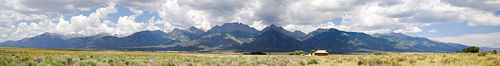
The Sangre de Cristo Range, called the East Range locally in the San Luis Valley, is a narrow mountain range
Mountain range
A mountain range is a single, large mass consisting of a succession of mountains or narrowly spaced mountain ridges, with or without peaks, closely related in position, direction, formation, and age; a component part of a mountain system or of a mountain chain...
of the Rocky Mountains
Rocky Mountains
The Rocky Mountains are a major mountain range in western North America. The Rocky Mountains stretch more than from the northernmost part of British Columbia, in western Canada, to New Mexico, in the southwestern United States...
running north and south along the east side of the Rio Grande Rift
Rio Grande Rift
The Rio Grande Rift is a north-trending continental rift zone. It separates the Colorado Plateau in the west from the interior of the North American craton on the east. The rift extends from central Colorado in the north to the state of Chihuahua, Mexico in the south. The rift zone consists of four...
in southern Colorado
Colorado
Colorado is a U.S. state that encompasses much of the Rocky Mountains as well as the northeastern portion of the Colorado Plateau and the western edge of the Great Plains...
in the United States
United States
The United States of America is a federal constitutional republic comprising fifty states and a federal district...
. The mountains extend southeast from Poncha Pass
Poncha Pass
Poncha Pass is a mountain pass in South-Central Colorado . It lies between the San Luis Valley to the south and the valley of the Arkansas River to the north, and is one of the lowest mountain passes in the state . It is in the saddle between the Sangre de Cristo Range, lying to the southeast, and...
for about 75 miles (120 km) through south-central Colorado to La Veta Pass, approximately 20 miles (32 km) west of Walsenburg
Walsenburg, Colorado
The City of Walsenburg or Los Leones is a Statutory City that is the county seat and the most populous city of Huerfano County, Colorado, United States...
, and form a high ridge separating the San Luis Valley
San Luis Valley
The San Luis Valley is an extensive alpine valley in the U.S. states of Colorado and New Mexico covering approximately and sitting at an average elevation of above sea level. The valley sits atop the Rio Grande Rift and is drained to the south by the Rio Grande River, which rises in the San Juan...
on the west from the watershed of the Arkansas River
Arkansas River
The Arkansas River is a major tributary of the Mississippi River. The Arkansas generally flows to the east and southeast as it traverses the U.S. states of Colorado, Kansas, Oklahoma, and Arkansas. The river's initial basin starts in the Western United States in Colorado, specifically the Arkansas...
on the east.
According to the USGS
United States Geological Survey
The United States Geological Survey is a scientific agency of the United States government. The scientists of the USGS study the landscape of the United States, its natural resources, and the natural hazards that threaten it. The organization has four major science disciplines, concerning biology,...
, the range is the northern part of the larger Sangre de Cristo Mountains
Sangre de Cristo Mountains
The Sangre de Cristo Mountains are the southernmost subrange of the Rocky Mountains. They are located in southern Colorado and northern New Mexico in the United States...
, which extend through northern New Mexico
New Mexico
New Mexico is a state located in the southwest and western regions of the United States. New Mexico is also usually considered one of the Mountain States. With a population density of 16 per square mile, New Mexico is the sixth-most sparsely inhabited U.S...
.
Usage of the terms "Sangre de Cristo Range" and "Sangre de Cristo Mountains" is varied; however this article discusses only the mountains between Poncha Pass and La Veta Pass.
Notable peaks
| Peak name | Elevation | Prominence Topographic prominence In topography, prominence, also known as autonomous height, relative height, shoulder drop , or prime factor , categorizes the height of the mountain's or hill's summit by the elevation between it and the lowest contour line encircling it and no higher summit... |
|---|---|---|
| Blanca Peak Blanca Peak Blanca Peak is the highest peak of the Sierra Blanca Massif at the southern tip of the Sangre de Cristo Mountains in the U.S. State of Colorado. It is the fourth highest peak of the Rocky Mountains, and the eighth highest peak in the contiguous United States.... |
14,345 ft = 4372.4 m | 5326 ft |
| Crestone Peak Crestone Peak Crestone Peak is the seventh highest peak in the U.S. state of Colorado. It is the second highest peak in the Sangre de Cristo Range after Blanca Peak. It rises in the Sangre de Cristo Wilderness above the east side of the San Luis Valley along the boundary between Saguache and Custer counties,... |
14,294 ft = 4356.8 m | 4534–4574 ft |
| Crestone Needle Crestone Needle Crestone Needle is one of the fourteeners of Colorado, in the heart of the Sangre de Cristo Range. It is part of a group of four fourteeners known as "the Crestones", headed by Crestone Peak and also including Kit Carson Mountain and Humboldt Peak.While not as high as Crestone Peak, and connected... |
14,197 ft = 4327.2 m | 437 ft |
| Kit Carson Peak Kit Carson Peak Kit Carson Peak is one of the 54 fourteeners in the state of Colorado. It lies in the Sangre de Cristo Range near Crestone Peak and Crestone Needle and is named after the frontiersman Kit Carson... |
14,165 ft = 4317.5 m | 1005 ft |
| Challenger Point Challenger Point Challenger Point is a fourteener in the Sangre de Cristo range, located in the southern part of the U.S. state of Colorado. The summit is on the northwest shoulder of Kit Carson Mountain, and is a subpeak of the latter... |
14,080 ft = 4291.6 m | 281 ft |
| Humboldt Peak Humboldt Peak (Colorado) Humboldt Peak is a high peak in the Sangre de Cristo Range in southern Colorado. It is the least challenging climb of the Crestone group of fourteeners, which include Crestone Peak, Crestone Needle, and Kit Carson Peak... |
14,064 ft = 4286.7 m | 1184–1224 ft |
| Ellingwood Point Ellingwood Point Ellingwood Point, or Ellingwood Peak, is a fourteener in the U.S. state of Colorado. It is located at the southern end of the Sangre de Cristo Range, approximately 1/2 mile northwest of Blanca Peak. It lies on the border between Alamosa County and Huerfano County... |
14,042 ft = 4280.0 m | 322 ft |
| Mount Lindsey Mount Lindsey Mount Lindsey is a fourteener in the US state of Colorado, located near Blanca Peak at the southern end of the Sangre de Cristo Range. It is the forty-third highest mountain in Colorado. The summit and most of the southern flank of the mountain are privately held, but access to the summit is allowed... |
14,042 ft = 4280.0 m | 1522–1562 ft |
| Little Bear Peak Little Bear Peak Little Bear Peak, or simply Little Bear, is one of the fourteeners of the US state of Colorado. It lies at the southern end of the Sangre de Cristo Range, which is the northern section of the Sangre de Cristo Mountains. Little Bear is just southwest of Blanca Peak, one of the highest and most... |
14,037 ft = 4278.5 m | 357 ft |
| Columbia Point Columbia Point Columbia Point is a 13,980 foot subpeak of Kit Carson Peak, in Colorado, USA. It was known informally as Kat Carson, but was officially named Columbia Point in 2003 to honor the seven astronauts who died when the Space Shuttle Columbia disintegrated during re-entry on February 1, 2003... |
13,980 ft = 4261.1 m | 320–360 ft |
| Mount Adams Mount Adams (Colorado) At in altitude, Mount Adams is ranked as the 66th highest mountain in the state of Colorado. It lies in the Sangre de Cristo Range north of Kit Carson Mountain, about five miles east of the town of Crestone, Colorado.-Climbing:... PB |
13,931 ft = 4246.2 m | 851 ft |
| California Peak PB | 13,849 ft = 4221.2 m | 609 ft |
| Rito Alto Peak PB | 13,794 ft = 4204 m | 1114–1154 ft |
| Colony Baldy PB | 13,705 ft = 4177 m | 905–945 ft |
| Pico Aislado http://www.bivouac.com/MtnPg.asp?MtnId=25460 | 13,612 ft = 4149 m | 837 ft |
| Tijeras Peak Tijeras Peak Tijeras Peak is the highest summit in Great Sand Dunes National Park and Preserve in Colorado. Located in the heart of the Sangre de Cristo Range, it is part of a group of six thirteeners at the north end of the park that includes Milwaukee Peak and Mount Herard... PB |
13,604 ft = 4146 m | |
| Electric Peak PB | 13,595 ft = 4144 m | |
| Cottonwood Peak Cottonwood Peak Cottonwood Peak is a mountain in northwestern British Columbia, Canada, located in the Iverson Creek area. It is a volcanic feature of the Northern Cordilleran Volcanic Province that formed in the past 1.6 million years during the Pleistocene Epoch.-See also:... PB |
13,588 ft = 4142 m | 1108–1148 ft |
| Twin Peaks http://www.13ers.com/peaks/SCR/photos_CaliforniaPeak.html | 13,577 ft = 4138.3 m | |
| Broken Hand Peak PB | 13,573 ft = 4137.1 m | 653 ft |
| Fluted Peak http://www.13ers.com/peaks/SCR/photos_MtAdams.html | 13,554 ft = 4131.3 m | |
| Milwaukee Peak http://www.13ers.com/peaks/SCR/photos_BrokenHand.html | 13,522 ft = 4121.5 m |
A more comprehensive list of Sangre de Cristo Mountains is given at Pikes Peak Photo and SummitPost sites: see External Links.
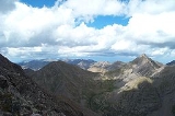
Geography
San Isabel National Forest
San Isabel National Forest is located in central Colorado. The forest contains 19 of the state's 54 fourteeners, peaks over high, including Mount Elbert, the highest point in Colorado....
, while most of the southwest (San Luis Valley) side is included in the Rio Grande National Forest
Rio Grande National Forest
Rio Grande National Forest is a 1.86 million acre U.S. National Forest located in southwestern Colorado. The forest encompasses the San Luis Valley, which is the world's largest agricultural alpine valley, as well as one of the worlds largest high deserts located around mountains. The...
. The central part of the range is designated as the Sangre de Cristo Wilderness
Sangre de Cristo Wilderness
The Sangre de Cristo Wilderness is a long and narrow wilderness area covering much of the Sangre de Cristo Range centered about Saguache County and Custer County, Colorado. Smaller areas are located in the counties of Fremont, Alamosa, and Huerfano. All of the wilderness area is located on U.S...
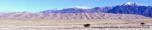
. The Great Sand Dunes National Park sits on the southwestern flank of the range at the edge of the San Luis Valley. The range divide is traversed by no paved roads, but only by four wheel drive
Four Wheel Drive
The Four Wheel Drive Auto Company, more often known as Four Wheel Drive or just FWD, was founded in 1909 in Clintonville, Wisconsin, as the Badger Four-Wheel Drive Auto Company by Otto Zachow and William Besserdich.-History:...
and foot trails over Hayden Pass, Hermit Pass, Music Pass, Medano Pass, and Mosca Pass.
The highest peak in the range, located in the south, is Blanca Peak
Blanca Peak
Blanca Peak is the highest peak of the Sierra Blanca Massif at the southern tip of the Sangre de Cristo Mountains in the U.S. State of Colorado. It is the fourth highest peak of the Rocky Mountains, and the eighth highest peak in the contiguous United States....
(14,345 feet/4,372 m); it is flanked by three other fourteeners, Little Bear Peak
Little Bear Peak
Little Bear Peak, or simply Little Bear, is one of the fourteeners of the US state of Colorado. It lies at the southern end of the Sangre de Cristo Range, which is the northern section of the Sangre de Cristo Mountains. Little Bear is just southwest of Blanca Peak, one of the highest and most...
, Mount Lindsey
Mount Lindsey
Mount Lindsey is a fourteener in the US state of Colorado, located near Blanca Peak at the southern end of the Sangre de Cristo Range. It is the forty-third highest mountain in Colorado. The summit and most of the southern flank of the mountain are privately held, but access to the summit is allowed...
, and Ellingwood Point
Ellingwood Point
Ellingwood Point, or Ellingwood Peak, is a fourteener in the U.S. state of Colorado. It is located at the southern end of the Sangre de Cristo Range, approximately 1/2 mile northwest of Blanca Peak. It lies on the border between Alamosa County and Huerfano County...
. Other well-known peaks are the fourteeners of the Crestone
Crestones
The Crestones are a group of four 14,000 foot peaks in the Sangre de Cristo Range above Crestone, Colorado, comprising:*Crestone Peak *Crestone Needle *Kit Carson Mountain...
group: Kit Carson Mountain, Crestone Peak
Crestone Peak
Crestone Peak is the seventh highest peak in the U.S. state of Colorado. It is the second highest peak in the Sangre de Cristo Range after Blanca Peak. It rises in the Sangre de Cristo Wilderness above the east side of the San Luis Valley along the boundary between Saguache and Custer counties,...
, Crestone Needle
Crestone Needle
Crestone Needle is one of the fourteeners of Colorado, in the heart of the Sangre de Cristo Range. It is part of a group of four fourteeners known as "the Crestones", headed by Crestone Peak and also including Kit Carson Mountain and Humboldt Peak.While not as high as Crestone Peak, and connected...
, and Humboldt Peak
Humboldt Peak (Colorado)
Humboldt Peak is a high peak in the Sangre de Cristo Range in southern Colorado. It is the least challenging climb of the Crestone group of fourteeners, which include Crestone Peak, Crestone Needle, and Kit Carson Peak...
. Two sub-peaks of Kit Carson Mountain, Challenger Point
Challenger Point
Challenger Point is a fourteener in the Sangre de Cristo range, located in the southern part of the U.S. state of Colorado. The summit is on the northwest shoulder of Kit Carson Mountain, and is a subpeak of the latter...
and Columbia Point
Columbia Point
Columbia Point is a 13,980 foot subpeak of Kit Carson Peak, in Colorado, USA. It was known informally as Kat Carson, but was officially named Columbia Point in 2003 to honor the seven astronauts who died when the Space Shuttle Columbia disintegrated during re-entry on February 1, 2003...
, are named in memory of the crews of the Space Shuttle Challenger
STS-51-L
STS-51-L was the twenty-fifth flight of the American Space Shuttle program, which marked the first time an ordinary civilian, schoolteacher Christa McAuliffe, had flown aboard the Space Shuttle. The mission used Space Shuttle Challenger, which lifted off from the Launch Complex 39-B on 28 January...
and the Space Shuttle Columbia
Space Shuttle Columbia disaster
The Space Shuttle Columbia disaster occurred on February 1, 2003, when shortly before it was scheduled to conclude its 28th mission, STS-107, the Space Shuttle Columbia disintegrated over Texas and Louisiana during re-entry into the Earth's atmosphere, resulting in the death of all seven crew members...
.
The range is also home to many high peaks in the 13,000 to 14,000 foot (3,900-4,300 m) range.
See the Sangre de Cristo Mountains
Sangre de Cristo Mountains
The Sangre de Cristo Mountains are the southernmost subrange of the Rocky Mountains. They are located in southern Colorado and northern New Mexico in the United States...
article for other noteworthy summits in the greater range.
History and economy
In 1719 the Spanish explorer Antonio Valverde y CosioAntonio Valverde y Cosío
- Biography :Antonio Valverde y Cosio was son of Antonio Velarde and Juana de Velarde y Cosio. He was appointed acting governor of New Mexico in 1716...
named the Sangre de Cristo ("Blood of Christ") mountains after being impressed by the reddish hue of the snowy peaks at sunrise, alpenglow
Alpenglow
Alpenglow is an optical phenomenon. When the Sun is just below the horizon, a horizontal red glowing band can sometimes be observed on the opposite horizon...
. Today tourism is the main economic activity.
Geology
The Sangre de Cristos are fault-block mountainMountain
Image:Himalaya_annotated.jpg|thumb|right|The Himalayan mountain range with Mount Everestrect 58 14 160 49 Chomo Lonzorect 200 28 335 52 Makalurect 378 24 566 45 Mount Everestrect 188 581 920 656 Tibetan Plateaurect 250 406 340 427 Rong River...
s with major fault lines running along both the east and west sides of the mountains and, in places, cutting through the range. The mountains were pushed up about 27 million years ago, basically as one large mass of rock.
San Luis Valley
The San Luis Valley is an extensive alpine valley in the U.S. states of Colorado and New Mexico covering approximately and sitting at an average elevation of above sea level. The valley sits atop the Rio Grande Rift and is drained to the south by the Rio Grande River, which rises in the San Juan...
with the Rio Grande Rift
Rio Grande Rift
The Rio Grande Rift is a north-trending continental rift zone. It separates the Colorado Plateau in the west from the interior of the North American craton on the east. The rift extends from central Colorado in the north to the state of Chihuahua, Mexico in the south. The rift zone consists of four...
running down the middle. On the southeast side is the Raton Basin
Raton Basin
The Raton Basin is a geologic structural basin in southern Colorado and northern New Mexico. It takes its name from Raton Pass and the town of Raton, New Mexico. In extent, the basin is approximately east-west, and north-south, in Huerfano and Las Animas Counties, Colorado, and Colfax County,...
, a quiet but still active volcanic field
Volcanic field
A volcanic field is an area of the Earth's crust that is prone to localized volcanic activity. They usually contain 10 to 100 volcanoes, such as cinder cones and are usually in clusters. Lava flows may also occur...
. On the northeast side are the Wet Mountains
Wet Mountains
The Wet Mountains are a small range of mountains in southern Colorado named for the amount of snow they receive in the winter. There are three variant names of this range: Cuerno Verde, Greenhorn Mountains, and Sierra Mojadas...
and the Front Range
Front Range
The Front Range is a mountain range of the Southern Rocky Mountains of North America located in the north-central portion of the U.S. State of Colorado and southeastern portion of the U.S. State of Wyoming. It is the first mountain range encountered moving west along the 40th parallel north across...
, areas of Precambrian
Precambrian
The Precambrian is the name which describes the large span of time in Earth's history before the current Phanerozoic Eon, and is a Supereon divided into several eons of the geologic time scale...
igneous
Igneous rock
Igneous rock is one of the three main rock types, the others being sedimentary and metamorphic rock. Igneous rock is formed through the cooling and solidification of magma or lava...
and metamorphic
Metamorphic rock
Metamorphic rock is the transformation of an existing rock type, the protolith, in a process called metamorphism, which means "change in form". The protolith is subjected to heat and pressure causing profound physical and/or chemical change...
rocks formed during the Colorado orogeny
Colorado orogeny
The Colorado orogeny, or Colorado orogen, was an orogeny in Colorado and surrounding areas which was a part of the development of the ancestral Rockies...
some 1.7 billion years ago and then uplifted more recently during the Laramide orogeny
Laramide orogeny
The Laramide orogeny was a period of mountain building in western North America, which started in the Late Cretaceous, 70 to 80 million years ago, and ended 35 to 55 million years ago. The exact duration and ages of beginning and end of the orogeny are in dispute, as is the cause. The Laramide...
.
The Blanca Massif
Blanca Peak
Blanca Peak is the highest peak of the Sierra Blanca Massif at the southern tip of the Sangre de Cristo Mountains in the U.S. State of Colorado. It is the fourth highest peak of the Rocky Mountains, and the eighth highest peak in the contiguous United States....
is also Precambrian rock, while most of the rest of the Sangres is composed of younger Permian
Permian
The PermianThe term "Permian" was introduced into geology in 1841 by Sir Sir R. I. Murchison, president of the Geological Society of London, who identified typical strata in extensive Russian explorations undertaken with Edouard de Verneuil; Murchison asserted in 1841 that he named his "Permian...
-Pennsylvanian
Pennsylvanian
The Pennsylvanian is, in the ICS geologic timescale, the younger of two subperiods of the Carboniferous Period. It lasted from roughly . As with most other geochronologic units, the rock beds that define the Pennsylvanian are well identified, but the exact date of the start and end are uncertain...
(about 250-million-year old) rock, a mix of sedimentary
Sedimentary rock
Sedimentary rock are types of rock that are formed by the deposition of material at the Earth's surface and within bodies of water. Sedimentation is the collective name for processes that cause mineral and/or organic particles to settle and accumulate or minerals to precipitate from a solution....
conglomerates
Conglomerate (geology)
A conglomerate is a rock consisting of individual clasts within a finer-grained matrix that have become cemented together. Conglomerates are sedimentary rocks consisting of rounded fragments and are thus differentiated from breccias, which consist of angular clasts...
, shale
Shale
Shale is a fine-grained, clastic sedimentary rock composed of mud that is a mix of flakes of clay minerals and tiny fragments of other minerals, especially quartz and calcite. The ratio of clay to other minerals is variable. Shale is characterized by breaks along thin laminae or parallel layering...
s, and igneous intrusion
Intrusion
An intrusion is liquid rock that forms under Earth's surface. Magma from under the surface is slowly pushed up from deep within the earth into any cracks or spaces it can find, sometimes pushing existing country rock out of the way, a process that can take millions of years. As the rock slowly...
s. These sedimentary rocks originated as sediment
Sediment
Sediment is naturally occurring material that is broken down by processes of weathering and erosion, and is subsequently transported by the action of fluids such as wind, water, or ice, and/or by the force of gravity acting on the particle itself....
eroded
Erosion
Erosion is when materials are removed from the surface and changed into something else. It only works by hydraulic actions and transport of solids in the natural environment, and leads to the deposition of these materials elsewhere...
from the Ancestral Rocky Mountains.
See also
- Colorado mountain ranges
- Geography of ColoradoGeography of ColoradoThe geography of the state of Colorado is diverse, encompassing both rugged mountainous terrain, vast plains, desert lands, desert canyons, and mesas. The state of Colorado is defined as the geospherical rectangle that stretches from 37°N to 41°N latitude and from 102°03'W to 109°03'W longitude . ...
- List of highest mountain peaks in Colorado
- Rocky MountainsRocky MountainsThe Rocky Mountains are a major mountain range in western North America. The Rocky Mountains stretch more than from the northernmost part of British Columbia, in western Canada, to New Mexico, in the southwestern United States...
- Sangre de Cristo MountainsSangre de Cristo MountainsThe Sangre de Cristo Mountains are the southernmost subrange of the Rocky Mountains. They are located in southern Colorado and northern New Mexico in the United States...
- State of Colorado
External links
- Rocky Mountains @ Peakbagger
- Table listing of all the thirteeners in Sangre de Cristo @ Pikes Peak Photo
- CO & NM Sangre de Cristo Mountains