
Snake Range
Encyclopedia
The Snake Range is a line of high mountains in eastern White Pine County
, in east-central Nevada
in the western United States
. Typical of other ranges in the Basin and Range Province, it runs in a north-south direction, in this case for approximately 60 miles (97 km). To the west is Spring Valley and the Schell Creek Range
, while to the east is the border with Utah
, Snake Valley
, and the Confusion Range
.
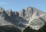
The Snake Range includes two groups of peaks. The southern section rises quickly from a point near the border with Lincoln County
, reaching the summit of Granite Peak (11,218 ft, 3419 m) just 10 miles (16 km) to the north. From there the range continues to rise, passing Lincoln Peak (11,597 ft, 3535 m), Mt. Washington (11,658 ft, 3553 m), Pyramid Peak (11,926 ft, 3635 m), Baker Peak (12,298 ft, 3748 m), Jeff Davis Peak (12,771 ft, 3893 m), and finally reaching its apex at Wheeler Peak
(13,063 ft, 3982 m). This area also includes the 83-foot (25 m) span of Lexington Arch, and Lehman Caves, both cut into limestone. Several large groves of Great Basin Bristlecone Pine
s thrive in this region.
In 1986 this southern section of the range was selected as the location of the Great Basin National Park
, recognizing both the unique geologic features of these mountains as well as their representation of the region as a whole.
From Wheeler Peak the range begins to drop, reaching 7154 feet (2,181 m) at Sacramento Pass, just 11 miles (17.7 km) to the north. Here is where U.S. Route 6
/U.S. Route 50
, the "Loneliest Highway in America", crosses the range, and provides the principal means of access to this area of eastern Nevada.
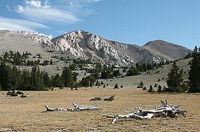
Sacramento Pass is also where the more remote northern section of the range begins. In just 12 miles (19 km) it rises past Silver Creek and Hendrys Creek Canyons to the summit of photogenic Mt. Moriah
(12,067 ft, 3678 m). To the north of this peak is an unusual formation, a flat surface of sub-alpine tundra
called "The Table", covering about 2 square miles (5.2 km²) and lying at an elevation of 11,000 feet (3350 m). Nestled on this surface near the mountain is a grove of ancient Bristlecone Pines.
North of 'The Table' is yet another unusual geologic feature. Deadman Creek and Smith Creek, draining eastward into Snake Valley, combine to carve a deep canyon into the range. The mouth of this canyon lies below 3000 feet (914.4 m) cliffs, 6000 feet (1,828.8 m) below (and just 6 miles (9.7 km) away from) the summit of Mt. Moriah. The higher elevations of this northern section of the Snake Range is protected as the Mount Moriah Wilderness Area, and the southern portion of the Range is protected as the Highland Ridge Wilderness
.
White Pine County, Nevada
White Pine County is a county located in the U.S. state of Nevada. Its population at the 2010 census was 10,030. Its county seat is Ely. It is the home of Great Basin National Park...
, in east-central Nevada
Nevada
Nevada is a state in the western, mountain west, and southwestern regions of the United States. With an area of and a population of about 2.7 million, it is the 7th-largest and 35th-most populous state. Over two-thirds of Nevada's people live in the Las Vegas metropolitan area, which contains its...
in the western United States
United States
The United States of America is a federal constitutional republic comprising fifty states and a federal district...
. Typical of other ranges in the Basin and Range Province, it runs in a north-south direction, in this case for approximately 60 miles (97 km). To the west is Spring Valley and the Schell Creek Range
Schell Creek Range
The Schell Creek Range is a linear mountain range in central White Pine County, in east-central Nevada. Its length is approximately in a north-south direction....
, while to the east is the border with Utah
Utah
Utah is a state in the Western United States. It was the 45th state to join the Union, on January 4, 1896. Approximately 80% of Utah's 2,763,885 people live along the Wasatch Front, centering on Salt Lake City. This leaves vast expanses of the state nearly uninhabited, making the population the...
, Snake Valley
Snake Valley (Utah)
Snake Valley is a north-south trending valley that straddles the Nevada Utah border in the central Great Basin. It is bound by the Snake Range and the Deep Creek Mountains to the west and the Confusion Range to the east...
, and the Confusion Range
Confusion Range
The Confusion Range is a north-south trending mountain range in west-central Utah. It is bounded by Snake Valley to the west, Tule Valley to the east, the Great Salt Lake Desert to the north, and the Ferguson Desert to the south. The range trends into the Burbank Hills, Mountain Home Range, and...
.
The Snake Range includes two groups of peaks. The southern section rises quickly from a point near the border with Lincoln County
Lincoln County, Nevada
Lincoln County is a county located in the U.S. state of Nevada. As of the 2000 census, the population was 4,165. Its county seat is Pioche.-History:...
, reaching the summit of Granite Peak (11,218 ft, 3419 m) just 10 miles (16 km) to the north. From there the range continues to rise, passing Lincoln Peak (11,597 ft, 3535 m), Mt. Washington (11,658 ft, 3553 m), Pyramid Peak (11,926 ft, 3635 m), Baker Peak (12,298 ft, 3748 m), Jeff Davis Peak (12,771 ft, 3893 m), and finally reaching its apex at Wheeler Peak
Wheeler Peak (Nevada)
Wheeler Peak, elevation , a mountain in the Great Basin Desert, is the highest point in Great Basin National Park. The summit is located west of the Utah border...
(13,063 ft, 3982 m). This area also includes the 83-foot (25 m) span of Lexington Arch, and Lehman Caves, both cut into limestone. Several large groves of Great Basin Bristlecone Pine
Great Basin Bristlecone Pine
Pinus longaeva, the Great Basin Bristlecone Pine, is a long-living species of tree found in the higher mountains of the southwest United States. The species is one of three closely related trees known as bristlecone pines and is sometimes known as the Intermountain or Western bristlecone pine...
s thrive in this region.
In 1986 this southern section of the range was selected as the location of the Great Basin National Park
Great Basin National Park
Great Basin National Park is a United States National Park established in 1986, located in east-central Nevada near the Utah border. The park derives its name from the Great Basin, the dry and mountainous region between the Sierra Nevada and the Wasatch Mountains. Topographically, this area is...
, recognizing both the unique geologic features of these mountains as well as their representation of the region as a whole.
From Wheeler Peak the range begins to drop, reaching 7154 feet (2,181 m) at Sacramento Pass, just 11 miles (17.7 km) to the north. Here is where U.S. Route 6
U.S. Route 6
U.S. Route 6 , also called the Grand Army of the Republic Highway, a name that honors an American Civil War veterans association, is a main route of the U.S. Highway system, running east-northeast from Bishop, California to Provincetown, Massachusetts. Until 1964, it continued south from Bishop to...
/U.S. Route 50
U.S. Route 50
U.S. Route 50 is a major east–west route of the U.S. Highway system, stretching just over from Ocean City, Maryland on the Atlantic Ocean to West Sacramento, California. Until 1972, when it was replaced by Interstate Highways west of the Sacramento area, it extended to San Francisco, near...
, the "Loneliest Highway in America", crosses the range, and provides the principal means of access to this area of eastern Nevada.
Sacramento Pass is also where the more remote northern section of the range begins. In just 12 miles (19 km) it rises past Silver Creek and Hendrys Creek Canyons to the summit of photogenic Mt. Moriah
Mt. Moriah (Nevada)
Mount Moriah is an east-central Nevada summit situated in the northern Snake Range. U.S. Highway 6 and Highway 50 traverse the Sacramento Pass which divides the northern and southern parts of the range. To the south of the pass is Great Basin National Park and Wheeler Peak. The mountain is about ...
(12,067 ft, 3678 m). To the north of this peak is an unusual formation, a flat surface of sub-alpine tundra
Alpine tundra
Alpine tundra is a natural region that does not contain trees because it is at high altitude. Alpine tundra is distinguished from arctic tundra, because alpine soils are generally better drained than arctic soils...
called "The Table", covering about 2 square miles (5.2 km²) and lying at an elevation of 11,000 feet (3350 m). Nestled on this surface near the mountain is a grove of ancient Bristlecone Pines.
North of 'The Table' is yet another unusual geologic feature. Deadman Creek and Smith Creek, draining eastward into Snake Valley, combine to carve a deep canyon into the range. The mouth of this canyon lies below 3000 feet (914.4 m) cliffs, 6000 feet (1,828.8 m) below (and just 6 miles (9.7 km) away from) the summit of Mt. Moriah. The higher elevations of this northern section of the Snake Range is protected as the Mount Moriah Wilderness Area, and the southern portion of the Range is protected as the Highland Ridge Wilderness
Highland Ridge Wilderness
Highland Ridge Wilderness is a wilderness area in the southern part of the Snake Range of White Pine County, just south of Great Basin National Park, in the U.S. state of Nevada. Located approximately south of the town of Baker, the Wilderness was designated in 2006 and is administered by the U.S...
.