
Absaroka Range
Encyclopedia
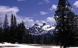
The Absaroka Range is a sub-range
of the Rocky Mountains
in the United States
. The range stretches about 150 mi (240 km) across the Montana
-Wyoming
border, forming the eastern boundary of Yellowstone National Park
and the western side of the Bighorn Basin
. The range borders the Beartooth Mountains
to the north and the Wind River Range
to the south. The highest peak in the range is Francs Peak
, located in Wyoming
at 13153 ft (4,009 m). There are 46 other peaks over 12000 ft (3,657.6 m). The range is named after the Absaroka
Indians. The name is derived from the Hidatsa
name for the Crow people; it means "children of the large-beaked bird."
The range is drained by the Yellowstone River
and various tributaries, including the Bighorn River
.
Most of the range lies within protected lands including Yellowstone Park, the Absaroka-Beartooth Wilderness
, North Absaroka Wilderness
, Teton Wilderness
, and Washakie Wilderness
, spanning the Bridger-Teton National Forest
, Custer National Forest
, Gallatin National Forest
, and Shoshone National Forest
.
U.S. Highway 212 from Billings, Montana
to Yellowstone climbs over Beartooth Pass 10947 ft (3,336.6 m) in the neighboring Beartooth Mountains
before winding through the Absarokas to the northeast gate of Yellowstone National Park
. It is only open during the summer. U.S Route 14/16/20
follows the Shoshone River
from Cody
through the range to the eastern gate of the park.
USS Absaroka
was named after this mountain range.
Mountain range
A mountain range is a single, large mass consisting of a succession of mountains or narrowly spaced mountain ridges, with or without peaks, closely related in position, direction, formation, and age; a component part of a mountain system or of a mountain chain...
of the Rocky Mountains
Rocky Mountains
The Rocky Mountains are a major mountain range in western North America. The Rocky Mountains stretch more than from the northernmost part of British Columbia, in western Canada, to New Mexico, in the southwestern United States...
in the United States
United States
The United States of America is a federal constitutional republic comprising fifty states and a federal district...
. The range stretches about 150 mi (240 km) across the Montana
Montana
Montana is a state in the Western United States. The western third of Montana contains numerous mountain ranges. Smaller, "island ranges" are found in the central third of the state, for a total of 77 named ranges of the Rocky Mountains. This geographical fact is reflected in the state's name,...
-Wyoming
Wyoming
Wyoming is a state in the mountain region of the Western United States. The western two thirds of the state is covered mostly with the mountain ranges and rangelands in the foothills of the Eastern Rocky Mountains, while the eastern third of the state is high elevation prairie known as the High...
border, forming the eastern boundary of Yellowstone National Park
Yellowstone National Park
Yellowstone National Park, established by the U.S. Congress and signed into law by President Ulysses S. Grant on March 1, 1872, is a national park located primarily in the U.S. state of Wyoming, although it also extends into Montana and Idaho...
and the western side of the Bighorn Basin
Bighorn Basin
The Bighorn Basin is a plateau region and intermontane basin, approximately 100 miles wide, in north-central Wyoming in the United States. It is bounded by the Absaroka Range on the west, the Bighorn Mountains on the east, and the Owl Creek Mountains and Bridger Mountains on the south...
. The range borders the Beartooth Mountains
Beartooth Mountains
The Beartooth Mountains are located in south central Montana and northwest Wyoming, U.S. and are part of the 900,000 acre Absaroka-Beartooth Wilderness, within Custer, Gallatin and Shoshone National Forests. The Beartooths are the location of Granite Peak, which at 12,807 feet is the highest...
to the north and the Wind River Range
Wind River Range
The Wind River Range , is a mountain range of the Rocky Mountains in western Wyoming in the United States. The range runs roughly NW-SE for approximately 100 miles . The Continental Divide follows the crest of the range and includes Gannett Peak, which at 13,804 feet , is the highest peak...
to the south. The highest peak in the range is Francs Peak
Francs Peak
Francs Peak is the highest point in the Absaroka Range which extends from north central Wyoming into south central Montana, in the United States. Located in the Washakie Wilderness of Shoshone National Forest, the peak is a relatively easy climb which can be achieved in less than a day...
, located in Wyoming
Wyoming
Wyoming is a state in the mountain region of the Western United States. The western two thirds of the state is covered mostly with the mountain ranges and rangelands in the foothills of the Eastern Rocky Mountains, while the eastern third of the state is high elevation prairie known as the High...
at 13153 ft (4,009 m). There are 46 other peaks over 12000 ft (3,657.6 m). The range is named after the Absaroka
Crow Nation
The Crow, also called the Absaroka or Apsáalooke, are a Siouan people of Native Americans who historically lived in the Yellowstone River valley, which extends from present-day Wyoming, through Montana and into North Dakota. They now live on a reservation south of Billings, Montana and in several...
Indians. The name is derived from the Hidatsa
Hidatsa language
Hidatsa is an endangered Siouan language, closely related to the Crow language. It is spoken by the Hidatsa tribe, primarily in North Dakota and South Dakota....
name for the Crow people; it means "children of the large-beaked bird."
The range is drained by the Yellowstone River
Yellowstone River
The Yellowstone River is a tributary of the Missouri River, approximately long, in the western United States. Considered the principal tributary of the upper Missouri, the river and its tributaries drain a wide area stretching from the Rocky Mountains in the vicinity of the Yellowstone National...
and various tributaries, including the Bighorn River
Bighorn River
The Bighorn River is a tributary of the Yellowstone, approximately long, in the western United States in the states of Wyoming and Montana. The river was named in 1805 by fur trader François Larocque for the Bighorn Sheep he saw along its banks as he explored the Yellowstone River.The upper...
.
Most of the range lies within protected lands including Yellowstone Park, the Absaroka-Beartooth Wilderness
Absaroka-Beartooth Wilderness
Absaroka-Beartooth Wilderness was created from existing National Forest lands in 1975 and is located in Montana and Wyoming, United States. The wilderness is partly in Gallatin, Custer and Shoshone National Forests and is composed of . The wilderness encompasses two distinct mountain ranges, namely...
, North Absaroka Wilderness
North Absaroka Wilderness
The North Absaroka Wilderness is located in Shoshone National Forest in the U.S. state of Wyoming. It lies adjacent to the eastern border of Yellowstone National Park.U.S. Wilderness Areas do not allow motorized or mechanized vehicles, including bicycles...
, Teton Wilderness
Teton Wilderness
Teton Wilderness is located in Wyoming, United States. Created in 1964, the Teton Wilderness is located within Bridger-Teton National Forest and consists of 585,238 acres . The wilderness is bordered on the north by Yellowstone National Park and to the west by Grand Teton National Park and the John...
, and Washakie Wilderness
Washakie Wilderness
The Washakie Wilderness is located in Shoshone National Forest in the U.S. state of Wyoming.U.S. Wilderness Areas do not allow motorized or mechanized vehicles, including bicycles. Although camping and fishing are allowed with proper permit, no roads or buildings are constructed and there is also...
, spanning the Bridger-Teton National Forest
Bridger-Teton National Forest
Bridger-Teton National Forest is located in western Wyoming, United States. The forest consists of , making it the second largest National Forest outside of Alaska. The forest stretches from Yellowstone National Park, along the eastern boundary of Grand Teton National Park and from there rides...
, Custer National Forest
Custer National Forest
Custer National Forest is located primarily in the southern part of the U.S. state of Montana but also has separate sections in northwestern South Dakota. With a total area of 1,278,279 acres , the forest comprises over 10 separate sections...
, Gallatin National Forest
Gallatin National Forest
Founded in 1899, Gallatin National Forest is located in south central Montana, United States. The forest comprises 2.1 million acres and has portions of both the Absaroka-Beartooth and Lee Metcalf Wilderness areas within its boundaries...
, and Shoshone National Forest
Shoshone National Forest
Shoshone National Forest is the first federally protected National Forest in the United States and covers nearly 2.5 million acres in the state of Wyoming. Originally a part of the Yellowstone Timberland Reserve, the forest was created by an act of Congress and signed into law by U.S....
.
U.S. Highway 212 from Billings, Montana
Billings, Montana
Billings is the largest city in the U.S. state of Montana, and is the principal city of the Billings Metropolitan Area, the largest metropolitan area in over...
to Yellowstone climbs over Beartooth Pass 10947 ft (3,336.6 m) in the neighboring Beartooth Mountains
Beartooth Mountains
The Beartooth Mountains are located in south central Montana and northwest Wyoming, U.S. and are part of the 900,000 acre Absaroka-Beartooth Wilderness, within Custer, Gallatin and Shoshone National Forests. The Beartooths are the location of Granite Peak, which at 12,807 feet is the highest...
before winding through the Absarokas to the northeast gate of Yellowstone National Park
Yellowstone National Park
Yellowstone National Park, established by the U.S. Congress and signed into law by President Ulysses S. Grant on March 1, 1872, is a national park located primarily in the U.S. state of Wyoming, although it also extends into Montana and Idaho...
. It is only open during the summer. U.S Route 14/16/20
U.S. Route 14
U.S. Route 14 , an east–west route, is one of the original United States highways of 1926. It currently has a length of 1,398 miles , but it had a peak length of 1,429 miles . For much of its length, it runs roughly parallel to Interstate 90.As of 2004, the highway's eastern terminus is in...
follows the Shoshone River
Shoshone River
The Shoshone River is long river in northern Wyoming in the United States. Its headwaters are in the Absaroka Range in Shoshone National Forest. It ends when it runs into the Big Horn River near Lovell, Wyoming. Cities it runs near or through are Cody, Powell, Byron, and Lovell. Near Cody, it...
from Cody
Cody, Wyoming
Cody is a city in Park County, Wyoming, United States. It is named after William Frederick Cody, primarily known as Buffalo Bill, from William Cody's part in the creation of the original town. The population was 9,520 at the 2010 census...
through the range to the eastern gate of the park.
USS Absaroka
USS Absaroka (1917)
USS Absaroka was a steamer in the service of the United States Navy, named after the Absaroka Range of mountains in Montana and Wyoming.Absaroka was built in 1917 for the United States Shipping Board by Skinner & Eddy Company, Seattle, Washington, taken over by the Navy on a bare boat basis on 17...
was named after this mountain range.
See also
- Mountains and mountain ranges of Yellowstone National ParkMountains and mountain ranges of Yellowstone National ParkYellowstone National Park, located primarily in the U.S. state of Wyoming, though the park also extends into Montana and Idaho and its Mountains and Mountain Ranges are part of the Rocky Mountains. There are at least 70 named mountain peaks over in Yellowstone in four mountain ranges...
- List of mountain ranges in Montana