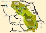
All Topics  
Big Horn Mountains

 
Big Horn Mountains

   Email Print
   Bookmark   Link


Big Horn Mountains


The Big Horn Mountains are a mountain range
Mountain range

A mountain range is a chain of mountains bordered by highlands or separated from other mountains by mountain pass or valleys. Individual mountains within the same mountain range do not necessarily have the same geology, though they often do; they may be a mix of different orogeny, for example volcanoes, uplifted mountains or Fold mountains...
 in northern Wyoming
Wyoming

The State of Wyoming is a sparsely populated U.S. state in the Northwestern United States of the United States. The majority of the state is dominated by the mountain ranges and rangelands of the Rocky Mountains, while the easternmost section of the state is a high altitude prairie region known as the High Plains ....
 and southern Montana
Montana

Montana is a U.S. state in the Western United States. The western third of the state contains numerous mountain ranges; other 'island' ranges are found in the central third of the state, for a total of 77 named ranges of the Rocky Mountains....
 in the United States
United States

The United States of America is a Federal government constitutional republic comprising U.S. state and a federal district. The country is situated mostly in central North America, where its Contiguous United States and Washington, D.C., the Capital districts and territories, lie between the Pacific Ocean and Atlantic Oceans, Borders of the U...
, forming a northwest-trending spur from the Rocky Mountains
Rocky Mountains

The Rocky Mountains, often called the Rockies, are a mountain range in western North America. The Rocky Mountains stretch more than 4,800 kilometre from the northernmost part of British Columbia, in Canada, to New Mexico, in the United States....
 extending approximately 200 miles (320 km) northward on the Great Plains
Great Plains

The Great Plains are the broad expanse of prairie and steppe which lie west of the Mississippi River and east of the Rocky Mountains in the United States and Canada....
. They are separated from the Absaroka Range
Absaroka Range

The Absaroka Range is a sub-mountain range of the Rocky Mountains in the United States. The range stretches for about 150 mi across the Montana-Wyoming border, forming the eastern boundary of Yellowstone National Park and the western side of the Big Horn Basin....
, which lie on the main branch of the Rockies in western Wyoming, by the Bighorn Basin
Bighorn Basin

The Bighorn Basin is a plateau region and intermontane basin, approximately 100 miles wide, in north-central Wyoming in the United States. It is bounded by the Absaroka Range on the west, the Bighorn Mountains on the east, and the Owl Creek Mountains and Bridger Mountains on the south....
.

The Bighorn Mountains were uplifted during the Laramide orogeny
Laramide orogeny

The Laramide orogeny was a period of mountain building in western North America, which started in the Late Cretaceous, 70 to 80 million years ago, and ended 35 to 55 million years ago....
 beginning approximately 70 million years ago.


Discussion
Ask a question about 'Big Horn Mountains'
Start a new discussion about 'Big Horn Mountains'
Answer questions from other users
Full Discussion Forum


Encyclopedia


The Big Horn Mountains are a mountain range
Mountain range

A mountain range is a chain of mountains bordered by highlands or separated from other mountains by mountain pass or valleys. Individual mountains within the same mountain range do not necessarily have the same geology, though they often do; they may be a mix of different orogeny, for example volcanoes, uplifted mountains or Fold mountains...
 in northern Wyoming
Wyoming

The State of Wyoming is a sparsely populated U.S. state in the Northwestern United States of the United States. The majority of the state is dominated by the mountain ranges and rangelands of the Rocky Mountains, while the easternmost section of the state is a high altitude prairie region known as the High Plains ....
 and southern Montana
Montana

Montana is a U.S. state in the Western United States. The western third of the state contains numerous mountain ranges; other 'island' ranges are found in the central third of the state, for a total of 77 named ranges of the Rocky Mountains....
 in the United States
United States

The United States of America is a Federal government constitutional republic comprising U.S. state and a federal district. The country is situated mostly in central North America, where its Contiguous United States and Washington, D.C., the Capital districts and territories, lie between the Pacific Ocean and Atlantic Oceans, Borders of the U...
, forming a northwest-trending spur from the Rocky Mountains
Rocky Mountains

The Rocky Mountains, often called the Rockies, are a mountain range in western North America. The Rocky Mountains stretch more than 4,800 kilometre from the northernmost part of British Columbia, in Canada, to New Mexico, in the United States....
 extending approximately 200 miles (320 km) northward on the Great Plains
Great Plains

The Great Plains are the broad expanse of prairie and steppe which lie west of the Mississippi River and east of the Rocky Mountains in the United States and Canada....
. They are separated from the Absaroka Range
Absaroka Range

The Absaroka Range is a sub-mountain range of the Rocky Mountains in the United States. The range stretches for about 150 mi across the Montana-Wyoming border, forming the eastern boundary of Yellowstone National Park and the western side of the Big Horn Basin....
, which lie on the main branch of the Rockies in western Wyoming, by the Bighorn Basin
Bighorn Basin

The Bighorn Basin is a plateau region and intermontane basin, approximately 100 miles wide, in north-central Wyoming in the United States. It is bounded by the Absaroka Range on the west, the Bighorn Mountains on the east, and the Owl Creek Mountains and Bridger Mountains on the south....
.

The Bighorn Mountains were uplifted during the Laramide orogeny
Laramide orogeny

The Laramide orogeny was a period of mountain building in western North America, which started in the Late Cretaceous, 70 to 80 million years ago, and ended 35 to 55 million years ago....
 beginning approximately 70 million years ago. The Bighorn Mountains consist of over of sedimentary rock strata laid down before mountain-building began: the predominantly marine and near-shore sedimentary layers range from the Cambrian
Cambrian

The Cambrian is a geologic period that began about Mya at the end of the Proterozoic eon and ended about Ma with the beginning of the Ordovician period ....
 through the Lower Cretaceous, and are often rich in fossil
Fossil

Fossils are the preserved remains or trace fossil of animals, plants, and other organisms from the remote past. The totality of fossils, both discovered and undiscovered, and their placement in fossiliferous Rock formations and sedimentary rock layers is known as the fossil record....
s. There is an unconformity
Unconformity

An unconformity is a buried erosion surface separating two Rock masses or Stratum of different ages, indicating that sediment deposition was not continuous....
 where Silurian
Silurian

The Silurian is a geologic period that extends from the end of the Ordovician period, about 443.7 ? 1.5 annum , to the beginning of the Devonian period, about 416.0 ? 2.8 Mya ....
 strata were exposed to erosion
Erosion

For morphological image processing operations, see Erosion 'For use of in dermatopathology, see Erosion Erosion is the removal of solids in the natural environment....
 and are missing. Following the uplift, large volumes of sediments, rich in early Tertiary
Tertiary

The Tertiary is a a term for a Geologic time scale#Terminology 65 million to 1.8 million years ago. The Tertiary covered the time span between the superseded Secondary period and an out-of-date definition of the Neogene#Controversy....
 paleontological resources, were deposited in the adjoining basins. Though many cirques
Cirque (landform)

A cirque is an amphitheatre-like valley, or valley head, formed at the head of a glacier by erosion. A cirque is also known as a coombe or coomb in England, a combe or comb in United States, a corrie in Scotland and Ireland, and a cwm in Wales, although these terms apply to a specific feature of which s...
, U-shaped valleys and glacial lake
Glacial lake

A glacial lake is a lake with origins in a melted glacier.Glacial lakes can be green as a result of pulverized minerals that support a large population of algae....
s can be found in the mountain range, the only remaining active glacier
Glacier

A glacier is a large, slow-moving mass of ice, formed from compacted layers of snow, that slowly deforms and flows in response to gravity and high pressure....
 is the Cloud Peak Glacier
Cloud Peak Glacier

Cloud Peak Glacier is located in the Bighorn Mountains in the northcentral section of the U.S. state of Wyoming. Centered within the Cloud Peak Wilderness of Bighorn National Forest, Cloud Peak Glacier is the only active glacier in the Bighorn Mountains....
, which is on the east slope of Cloud Peak
Cloud Peak

Cloud Peak is the highest peak within the Big Horn Mountains in the U.S. state of Wyoming. It rises to an elevation of and provides onlookers with dramatic views and vistas....
.

The highest peaks within the Big Horns are located in Wyoming in the 1.1 million acre (4,500 kmē) Bighorn National Forest
Bighorn National Forest

Bighorn National Forest is located in northern Wyoming, United States and consists of over 1.1 million acres . Created as a US Forest Reserve in 1897, it is one of the oldest government-protected forest lands in the U.S....
. Two peaks rise to over 13,000 feet (3,960 m) Cloud Peak (13,167 ft, 4013 m) and Black Tooth Mountain
Black Tooth Mountain

Black Tooth Mountain is located in the Bighorn Mountains in the U.S. state of Wyoming. The peak is the second highest in the range after Cloud Peak....
 (13,005 ft, 3964 m). There are a dozen more that rise to over 12,000 feet (3,650 m). From the east the mountains present a vertical relief of over 8,000 feet (2,450 m), rising abrutly from the plains. Overall, the Big Horns are more rounded than their sister mountain ranges to the west.

The range is the location of the headwaters of the Little Bighorn
Little Bighorn River

The Little Bighorn River is a tributary of the Bighorn River in the United States in the states of Wyoming and Montana. The Battle of the Little Bighorn was fought along its banks in 1876....
, Tongue
Tongue River (Montana)

The Tongue River is a tributary of the Yellowstone River, approximately 265 mi long, in the U.S. states of Wyoming and Montana. The Tongue rises in Wyoming in the Big Horn Mountains, flows through northern Wyoming and southeastern Montana and empties into the Yellowstone River at Miles City, Montana....
, and Powder
Powder River (Montana)

The Powder River is a tributary of the Yellowstone River, approximately long in the southeastern Montana and northeastern Wyoming in the United States....
 rivers.

Bighorn Canyon National Recreation Area

Bighorn Canyon National Recreation Area was established by an act of Congress on October 15, 1966, following the construction of the Yellowtail Dam by the Bureau of Reclamation....
 consists of approximately within the Bighorn Mountains. It includes Bighorn Lake
Bighorn Lake

Bighorn Lake is a reservoir in the United States located in Southern Montana and Northern Wyoming in the Bighorn Canyon National Recreation Area....
, a reservoir damming the Bighorn River
Bighorn River

The Bighorn River is a tributary of the Yellowstone River, approximately 461 mi long, in the western United States in the states of Wyoming and Montana....
.

The Big Horn Mountains are home to one of the elite ultramarathon
Ultramarathon

An ultramarathon is any sporting event involving running longer than the traditional marathon length of .There are two general types of ultramarathon events: those that cover a specified distance, and events that take place during specified time ....
s in the nation. The Big Horn Trail Run
Big Horn Trail Run

The Big Horn Trail run is a race held each June in the U.S. state of Wyoming's Big Horn Mountains. The race distances are 30 kilometers, 50 kilometers, 50 miles, and 100 miles....
 is held every June.

The Big Horns are a popular destination for hiking, backpacking, fly fishing and horse back riding. Trails wind through most of the national forest. The Cloud Peak Wilderness
Cloud Peak Wilderness

The Cloud Peak Wilderness is located in north central Wyoming in the United States. Entirely within Bighorn National Forest, the wilderness was established in 1984 in an effort to preserve the wildest section of the Bighorn Mountains....
 has a network of hiking trails to remote areas and alpine lakes. Higher trails are often covered with snow except from July through August. After Labor Day, there is a good chance of high country snow storms at any time.

The three highways traversing the Big Horn Mountains are so scenic and unique that they are designated Scenic Byways by the US Forest Service and the State of Wyoming. These include U.S. Route 14
U.S. Route 14

U.S. Route 14 , an east-west route, is one of the original United States highways of 1926. It currently has a length of 1,398 miles , but it had a peak length of 1,429 miles ....
, 14A, and 16.

External links