
St. Boswells
Encyclopedia
St Boswells is a village (population 1,086) on the south side of the River Tweed
in the Scottish Borders
. It lies about 1 mile SE of Newtown St Boswells on the A68 road
.
 It has a hotel, post office, award winning butcher, garage, fish and chip shop, bookshop and café and several convenience stores. There is also a golf course next to the River Tweed and a rugby club.
The village is mostly known for being on the route of St Cuthbert's Way, a long distance footpath linking Melrose Abbey
(5 miles northwest) to the Holy Island of Lindisfarne
off the Northumberland
coast in north east England
. The name commemorates Saint Boisil
, an Abbot of Melrose.
The village has an annual gypsy fair, originally a focus for the trade of horses. This fair once attracted Gypsies from most parts of Scotland, northern England and Ireland
. However, today it is little more than a two day get-together on the village green. Fair day is on 18 July each year. It remains a popular opportunity for many locals to have their fortune
s predicted.
came to this area in an attempt to extend the northern limits of their empire. At that time the Tweed valley was a land of open moor, bogs and forest inhabited by red deer
and wild boar. The marshes were home to wildfowl and salmon
were plentiful in the rivers. There were small settlements of Celtic
speaking pagans who hunted, fished and engaged in rudimentary cultivation of crops. The invading armies built their roads and military bases, fought their battles and then withdrew into history, leaving Trimontium and Dere Street
as evidence of their occupation. The years following the departure of the Romans saw gradual changes. Tribal warfare, intermarriage and trade each brought new influences until eventually the area came under the sway of the Anglian kingdom of Northumbria
.
In the 7th century Northumbria was ruled by the pagan leader Oswald
who, upon converting to Christianity
, established, with the help of St Aidan
, a monastery at Lindisfarne
, the Holy Island. A group of young monks studied under Aidan and under his leadership they journeyed up the Tweed to build another monastery at Old Mailros. From this new religious centre monks were sent out to establish themselves as missionaries within the community. One of these monks who set up in this area and became especially known for his powers of healing was Boisil
, and he it was who gave his name to the village and parish of Saint Boswells.
Boisil set up his cell by the river and administered to the inhabitants of the settlement which grew up around him. It is suggested that some of the dwellings were on the flat haugh below Benrig - a good site but prone to flooding, which may explain why they eventually moved to the higher ground at Lessudden (the place of Aidan) and the present site of St Boswells.
St Boswells gave its name to a settlement in southwest Saskatchewan
, Canada. The settlement was founded in the early 20th century, and flourished up to the mid 1930s. With depopulation after World War Two it failed in the 1960s and is no longer in existence.
under the Earl of Hertford
razed the Border Abbeys and caused destruction of dwellings in the village including Lessuden House, which was later rebuilt. Nearby this house stood the original village church called St Mary's which was established in the 12th century in the reign of David I
. Through time the worshippers moved to a church erected at Benrig near St Boisil's Chapel which, with repeated repairs and reconstructions, stood until 1952 when it was finally demolished.
The worshippers from Benrig moved to the church in the village which itself has a history. In 1843, after a period of theological disaffection. One third of all ministers in the Church of Scotland
walked out
of the Assembly, mainly on the question of patronage, and formed the Free Church
. A congregation was formed in St Boswells and originally met in a barn behind the old smiddy until a new church could be built in 1844. The re-unifications of 1900 and 1929 brought separated groups together again as one congregation and they worshipped in the building which has been variously known as St Boswells Free Church, the United Free Church, St Modans and now, St Boswells Parish Church. The building, still standing, was renovated in 1959.
, Peebles
and Melrose
for the making of bread
and beer
, and carts returning from Dalkeith brought lime
for the soil.
Improvement in farm implements led to changes in farming and large-scale industrialization put an end to much traditional farm work. An interesting note to the agricultural heritage of the community is that there was resistance from the village residents in the late l9th century to the removal of pig-sties from private homes and it is on record that there were eight farms in the village which were required to be registered as dairies.
Apart from agriculture and related industries, village life comprised many other trading activities necessary to a self-sufficient community. Joiner
s, plumber
s, builder
s, draper
s, baker
s, butcher
s, fishmonger
s, publican
s, carters, undertakers and bankers all managed to make a living from premises within the village boundaries. Modern life, ease of travel and changes in the nature of economic thinking have inevitably led to the depletion of local businesses.
is a remnant of the first public water system fed from Clintmains
by lead pipes. Paraffin
street lamps introduced in 1870 were replaced by gas-lamps in 1912. Electric street-lighting came in 1929. Two oil lamps, dated 1902, can still be seen on brackets attached to the end of the Public Hall. The old school at the top of Weirgate Brae was pulled down and a new one built in 1836 at what is now Hamilton Place. One of the builders of the schoolhouse was John Smith of Darnick
who also sculpted the William Wallace Statue
at Bemersyde House
near Dryburgh
. Mertoun Bridge was built to replace the old ford across the river, and population growth led to the building of the sandstone houses at West Croft and Jenny Moore's Road. The Public Hall was officially opened in 1896 and came to be used not only as a venue for public events, but also as a depository for village paraphernalia and as a storeroom for equipment belonging to the village fire-brigade. The hall still sees good use today by many community groups.
A great boon for the economy of the village was the building of the Kennels in 1836 for the Duke of Buccleuch
's pack. The hunting
season brought many visitors and this led to the building of the Buccleuch
Arms Hotel. At this time the local smiddy showed good business sense by moving from the east end of the village to the present location at the west end, in order, we can suppose, to be nearer the Kennels which, at one time, stabled as many as fifty horses.
Many of the roads in the area originated as paths for walking or riding to the Auld Kirk at Benrig, or as access roads to farms and fields. The main roads to Melrose, Jedburgh
and Kelso operated a turnpike
system which meant that the horse-drawn coaches, some of which ran on a daily basis, had to pay road-tax at the various tollhouses, one of which can still be seen at Mertoun Bridge.
One of the biggest changes in country life was the arrival of the railway in 1849. The initial building of the rail track, then operation and maintenance of the line meant new jobs for some and loss of jobs for others. The Waverley Line
ran to the west of St Boswells and the nearest station was at Newtown. One local business which did not lose out to the railway was operated by the Henderson brothers who ran a horse-drawn cab service to and from the station which was much used for both passengers and goods delivery,. When times changed the brothers were envied by many when they purchased a Model T Ford, one of the first cars to be seen in the parish. The railway line was closed in 1969, but there is now public discussion about the possibility of its revival. The village green
, still of considerable size, was once even bigger and old maps show it stretching as far as the tennis courts and up the west side of the A68 to behind the Kennels and across the cricket pitch. Originally common pasture land, its size and uses have changed from time to time and it has been used for sports, games, picnics, festivities and even military encampment.
Perhaps the best known use of the Green is the historic St Boswells Fair which is held on the 18 July every year. The fair used to be held on the flat haugh below Benrig but in 1743 the river level rose as a result of heavy rains and the Fair was flooded. With wet feet but undampened spirits, a decision was made to move the venue to the Green, and it has been held there ever since. Originally a sheep fair and a wool
market, it came to be a selling point for cattle and horses. It was not uncommon for a thousand horses to change hands over the period of the Fair. Gypsies came in their brightly decorated wagons from other parts of Scotland, England and even Ireland. It was a time for merriment and fun making, with kiosks, booths and campfires offering a change from daily routine for local residents. The tradition continues and the Fair is still held on the same date every year, but in a greatly reduced form.
The civic awareness which inspired the planting of trees on the Green to commemorate events such as Queen Victoria's Diamond Jubilee, the Boer War
, the coronation of George V
and the Buccleuch Golden Wedding has given us a pleasant place to walk and think and be at peace.
The war years saw much activity in the village and the area was virtually taken over by the Army for various uses. There was a munitions factory at Charlesfield. Stores and fuel dumps were round every corner. The soldiers, many of whom were billeted in the Kennels, had support from the Home Guard, air raid wardens and voluntary ambulance drivers. Canteen facilities and first aid were provided by local organisations. Residents of the village, men and women, young and old, were united in their support of the war effort.
it has given satisfaction to anglers over the years. Many of the local houses were built of stones from the river bed. The riverside walks are at all times pleasant and sometimes spectacular. Walkers on St Cuthbert's Way through the village on pilgrimage from Melrose to Lindisfarne
see the same view of the Eildon Hills as was seen by such men as Modan who established a religious cell at Dryburgh; Aidan who brought twelve young monks from Lindisfarne to Old Melrose as missionaries; Cuthbert who became prior and bishop and Boisil who, after a life of holiness and healing gave his name to the village and parish of St Boswells.
Perhaps unusually for Scotland, part of the Green was given over to cricket
. The present Club was constituted in 1895 and the current pitch, a gift from the Duke of Buccleuch
used since the 1920s. About the same time the Curling
Club was also formed. Using water from the Laret Burn, a pond was constructed just beyond the Green just about where the tennis courts now stand. Perhaps the winters really were more severe in days gone past because ice did form and games went ahead. Trees were planted at strategic points to prevent the sun's rays melting the ice. The pond was closed in 1964 and the club moved to Kelso indoor rink.
The cricket team has seen the most success having a brief spell in the national league in 2006 and winning the Border League four times between 2004 and 2008. The football and rugby team haven't seen similar fortune, though - both clubs finishing bottom of their respective leagues in the 2005-06 season. A comprehensive list of the St Boswells sports clubs is given below.
River Tweed
The River Tweed, or Tweed Water, is long and flows primarily through the Borders region of Great Britain. It rises on Tweedsmuir at Tweed's Well near where the Clyde, draining northwest, and the Annan draining south also rise. "Annan, Tweed and Clyde rise oot the ae hillside" as the Border saying...
in the Scottish Borders
Scottish Borders
The Scottish Borders is one of 32 local government council areas of Scotland. It is bordered by Dumfries and Galloway in the west, South Lanarkshire and West Lothian in the north west, City of Edinburgh, East Lothian, Midlothian to the north; and the non-metropolitan counties of Northumberland...
. It lies about 1 mile SE of Newtown St Boswells on the A68 road
A68 road
The A68 is a major road in the United Kingdom, running from Darlington in England to the A720 in Scotland.From Darlington, the road runs north, bypassing Bishop Auckland, and running through West Auckland, Toft Hill and Tow Law, past Consett and Corbridge...
.
The village is mostly known for being on the route of St Cuthbert's Way, a long distance footpath linking Melrose Abbey
Melrose Abbey
Melrose Abbey is a Gothic-style abbey in Melrose, Scotland. It was founded in 1136 by Cistercian monks, on the request of King David I of Scotland. It was headed by the Abbot or Commendator of Melrose. Today the abbey is maintained by Historic Scotland...
(5 miles northwest) to the Holy Island of Lindisfarne
Lindisfarne
Lindisfarne is a tidal island off the north-east coast of England. It is also known as Holy Island and constitutes a civil parish in Northumberland...
off the Northumberland
Northumberland
Northumberland is the northernmost ceremonial county and a unitary district in North East England. For Eurostat purposes Northumberland is a NUTS 3 region and is one of three boroughs or unitary districts that comprise the "Northumberland and Tyne and Wear" NUTS 2 region...
coast in north east England
England
England is a country that is part of the United Kingdom. It shares land borders with Scotland to the north and Wales to the west; the Irish Sea is to the north west, the Celtic Sea to the south west, with the North Sea to the east and the English Channel to the south separating it from continental...
. The name commemorates Saint Boisil
Boisil
Saint Boisil was the Abbot of Melrose Abbey, now in Scotland.Almost all that is known of Saint Boisil is learned from Bede. He derived his information from Sigfrid, a monk of Jarrow, who had previously been trained by Boisil at Melrose...
, an Abbot of Melrose.
The village has an annual gypsy fair, originally a focus for the trade of horses. This fair once attracted Gypsies from most parts of Scotland, northern England and Ireland
Ireland
Ireland is an island to the northwest of continental Europe. It is the third-largest island in Europe and the twentieth-largest island on Earth...
. However, today it is little more than a two day get-together on the village green. Fair day is on 18 July each year. It remains a popular opportunity for many locals to have their fortune
Prophecy
Prophecy is a process in which one or more messages that have been communicated to a prophet are then communicated to others. Such messages typically involve divine inspiration, interpretation, or revelation of conditioned events to come as well as testimonies or repeated revelations that the...
s predicted.
History
Almost two thousand years ago the RomansRoman Empire
The Roman Empire was the post-Republican period of the ancient Roman civilization, characterised by an autocratic form of government and large territorial holdings in Europe and around the Mediterranean....
came to this area in an attempt to extend the northern limits of their empire. At that time the Tweed valley was a land of open moor, bogs and forest inhabited by red deer
Red Deer
The red deer is one of the largest deer species. Depending on taxonomy, the red deer inhabits most of Europe, the Caucasus Mountains region, Asia Minor, parts of western Asia, and central Asia. It also inhabits the Atlas Mountains region between Morocco and Tunisia in northwestern Africa, being...
and wild boar. The marshes were home to wildfowl and salmon
Salmon
Salmon is the common name for several species of fish in the family Salmonidae. Several other fish in the same family are called trout; the difference is often said to be that salmon migrate and trout are resident, but this distinction does not strictly hold true...
were plentiful in the rivers. There were small settlements of Celtic
Celtic languages
The Celtic languages are descended from Proto-Celtic, or "Common Celtic"; a branch of the greater Indo-European language family...
speaking pagans who hunted, fished and engaged in rudimentary cultivation of crops. The invading armies built their roads and military bases, fought their battles and then withdrew into history, leaving Trimontium and Dere Street
Dere Street
Dere Street or Deere Street, was a Roman road between Eboracum and Veluniate, in what is now Scotland. It still exists in the form of the route of many major roads, including the A1 and A68 just north of Corbridge.Its name corresponds with the post Roman Anglo-Saxon kingdom of Deira, through...
as evidence of their occupation. The years following the departure of the Romans saw gradual changes. Tribal warfare, intermarriage and trade each brought new influences until eventually the area came under the sway of the Anglian kingdom of Northumbria
Northumbria
Northumbria was a medieval kingdom of the Angles, in what is now Northern England and South-East Scotland, becoming subsequently an earldom in a united Anglo-Saxon kingdom of England. The name reflects the approximate southern limit to the kingdom's territory, the Humber Estuary.Northumbria was...
.
In the 7th century Northumbria was ruled by the pagan leader Oswald
Oswald of Northumbria
Oswald was King of Northumbria from 634 until his death, and is now venerated as a Christian saint.Oswald was the son of Æthelfrith of Bernicia and came to rule after spending a period in exile; after defeating the British ruler Cadwallon ap Cadfan, Oswald brought the two Northumbrian kingdoms of...
who, upon converting to Christianity
Christianity
Christianity is a monotheistic religion based on the life and teachings of Jesus as presented in canonical gospels and other New Testament writings...
, established, with the help of St Aidan
Aidan of Lindisfarne
Known as Saint Aidan of Lindisfarne, Aidan the Apostle of Northumbria , was the founder and first bishop of the monastery on the island of Lindisfarne in England. A Christian missionary, he is credited with restoring Christianity to Northumbria. Aidan is the Anglicised form of the original Old...
, a monastery at Lindisfarne
Lindisfarne
Lindisfarne is a tidal island off the north-east coast of England. It is also known as Holy Island and constitutes a civil parish in Northumberland...
, the Holy Island. A group of young monks studied under Aidan and under his leadership they journeyed up the Tweed to build another monastery at Old Mailros. From this new religious centre monks were sent out to establish themselves as missionaries within the community. One of these monks who set up in this area and became especially known for his powers of healing was Boisil
Boisil
Saint Boisil was the Abbot of Melrose Abbey, now in Scotland.Almost all that is known of Saint Boisil is learned from Bede. He derived his information from Sigfrid, a monk of Jarrow, who had previously been trained by Boisil at Melrose...
, and he it was who gave his name to the village and parish of Saint Boswells.
Boisil set up his cell by the river and administered to the inhabitants of the settlement which grew up around him. It is suggested that some of the dwellings were on the flat haugh below Benrig - a good site but prone to flooding, which may explain why they eventually moved to the higher ground at Lessudden (the place of Aidan) and the present site of St Boswells.
St Boswells gave its name to a settlement in southwest Saskatchewan
Saskatchewan
Saskatchewan is a prairie province in Canada, which has an area of . Saskatchewan is bordered on the west by Alberta, on the north by the Northwest Territories, on the east by Manitoba, and on the south by the U.S. states of Montana and North Dakota....
, Canada. The settlement was founded in the early 20th century, and flourished up to the mid 1930s. With depopulation after World War Two it failed in the 1960s and is no longer in existence.
Lessuden
Lessuden village, as it was then known, consisted of one long street, now Main Street, and a narrow back-road which ran along Braeheads, on the high banks of the river. Several paths connected Braeheads to the main street. The form of the old village remains pretty much today as it was in times gone past. It probably was not much different in 1544 when the army of Henry VIII of EnglandHenry VIII of England
Henry VIII was King of England from 21 April 1509 until his death. He was Lord, and later King, of Ireland, as well as continuing the nominal claim by the English monarchs to the Kingdom of France...
under the Earl of Hertford
Edward Seymour, 1st Duke of Somerset
Edward Seymour, 1st Duke of Somerset, 1st Earl of Hertford, 1st Viscount Beauchamp of Hache, KG, Earl Marshal was Lord Protector of England in the period between the death of Henry VIII in 1547 and his own indictment in 1549....
razed the Border Abbeys and caused destruction of dwellings in the village including Lessuden House, which was later rebuilt. Nearby this house stood the original village church called St Mary's which was established in the 12th century in the reign of David I
David I of Scotland
David I or Dabíd mac Maíl Choluim was a 12th-century ruler who was Prince of the Cumbrians and later King of the Scots...
. Through time the worshippers moved to a church erected at Benrig near St Boisil's Chapel which, with repeated repairs and reconstructions, stood until 1952 when it was finally demolished.
The worshippers from Benrig moved to the church in the village which itself has a history. In 1843, after a period of theological disaffection. One third of all ministers in the Church of Scotland
Church of Scotland
The Church of Scotland, known informally by its Scots language name, the Kirk, is a Presbyterian church, decisively shaped by the Scottish Reformation....
walked out
Disruption of 1843
The Disruption of 1843 was a schism within the established Church of Scotland, in which 450 ministers of the Church broke away, over the issue of the Church's relationship with the State, to form the Free Church of Scotland...
of the Assembly, mainly on the question of patronage, and formed the Free Church
Free Church of Scotland (1843-1900)
The Free Church of Scotland is a Scottish denomination which was formed in 1843 by a large withdrawal from the established Church of Scotland in a schism known as the "Disruption of 1843"...
. A congregation was formed in St Boswells and originally met in a barn behind the old smiddy until a new church could be built in 1844. The re-unifications of 1900 and 1929 brought separated groups together again as one congregation and they worshipped in the building which has been variously known as St Boswells Free Church, the United Free Church, St Modans and now, St Boswells Parish Church. The building, still standing, was renovated in 1959.
Employment
For many generations the main source of employment in the parish was agriculture. The village lands were divided into two parts—infield and outfield. The infield was cultivated for the growing of crops and the outfield was pasture. Crops grown included wheat, barley and peas. Turnips were a successful later addition. The scrubland and clay soil of the parish meant lots of hard work re-claiming land, drainage work, and liming. Wheat and barley were taken by cart to DalkeithDalkeith
Dalkeith is a town in Midlothian, Scotland, lying on the River North Esk. It was granted a burgh of barony in 1401 and a burgh of regality in 1540...
, Peebles
Peebles
Peebles is a burgh in the committee area of Tweeddale, in the Scottish Borders, lying on the River Tweed. According to the 2001 Census, the population was 8,159.-History:...
and Melrose
Melrose, Scotland
Melrose is a small town and civil parish in the Scottish Borders, historically in Roxburghshire. It is in the Eildon committee area.-Etymology:...
for the making of bread
Bread
Bread is a staple food prepared by cooking a dough of flour and water and often additional ingredients. Doughs are usually baked, but in some cuisines breads are steamed , fried , or baked on an unoiled frying pan . It may be leavened or unleavened...
and beer
Beer
Beer is the world's most widely consumed andprobably oldest alcoholic beverage; it is the third most popular drink overall, after water and tea. It is produced by the brewing and fermentation of sugars, mainly derived from malted cereal grains, most commonly malted barley and malted wheat...
, and carts returning from Dalkeith brought lime
Lime (mineral)
Lime is a general term for calcium-containing inorganic materials, in which carbonates, oxides and hydroxides predominate. Strictly speaking, lime is calcium oxide or calcium hydroxide. It is also the name for a single mineral of the CaO composition, occurring very rarely...
for the soil.
Improvement in farm implements led to changes in farming and large-scale industrialization put an end to much traditional farm work. An interesting note to the agricultural heritage of the community is that there was resistance from the village residents in the late l9th century to the removal of pig-sties from private homes and it is on record that there were eight farms in the village which were required to be registered as dairies.
Apart from agriculture and related industries, village life comprised many other trading activities necessary to a self-sufficient community. Joiner
Joiner
A joiner differs from a carpenter in that joiners cut and fit joints in wood that do not use nails. Joiners usually work in a workshop since the formation of various joints generally requires non-portable machinery. A carpenter normally works on site...
s, plumber
Plumber
A plumber is a tradesperson who specializes in installing and maintaining systems used for potable water, sewage, and drainage in plumbing systems. The term dates from ancient times, and is related to the Latin word for lead, "plumbum." A person engaged in fixing metaphorical "leaks" may also be...
s, builder
Construction worker
A construction worker or builder is a professional, tradesman, or labourer who directly participates in the physical construction of infrastructure.-Construction trades:...
s, draper
Draper
Draper is the now largely obsolete term for a wholesaler, or especially retailer, of cloth, mainly for clothing, or one who works in a draper's shop. A draper may additionally operate as a cloth merchant or a haberdasher. The drapers were an important trade guild...
s, baker
Baker
A baker is someone who bakes and sells bread, Cakes and similar foods may also be produced, as the traditional boundaries between what is produced by a baker as opposed to a pastry chef have blurred in recent decades...
s, butcher
Butcher
A butcher is a person who may slaughter animals, dress their flesh, sell their meat or any combination of these three tasks. They may prepare standard cuts of meat, poultry, fish and shellfish for sale in retail or wholesale food establishments...
s, fishmonger
Fishmonger
A fishmonger is someone who sells fish and seafood...
s, publican
Publican
In antiquity, publicans were public contractors, in which role they often supplied the Roman legions and military, managed the collection of port duties, and oversaw public building projects...
s, carters, undertakers and bankers all managed to make a living from premises within the village boundaries. Modern life, ease of travel and changes in the nature of economic thinking have inevitably led to the depletion of local businesses.
Village life
The 19th century saw many changes in St Boswells. The water-fountain in Main Street erected by Lord Polwarth of MertounMertoun House
Mertoun House is a country house situated by the River Tweed, east of St Boswells in the Scottish Borders. It is home to the Duke of Sutherland for the majority of the year. The early 18th-century house is category-A listed, and was designed by Sir William Bruce...
is a remnant of the first public water system fed from Clintmains
Clintmains
Clintmains is a village by the River Tweed, in the parish of Mertoun, to the east of Newtown St Boswells, in the Scottish Borders area of Scotland, in the former Berwickshire....
by lead pipes. Paraffin
Paraffin
In chemistry, paraffin is a term that can be used synonymously with "alkane", indicating hydrocarbons with the general formula CnH2n+2. Paraffin wax refers to a mixture of alkanes that falls within the 20 ≤ n ≤ 40 range; they are found in the solid state at room temperature and begin to enter the...
street lamps introduced in 1870 were replaced by gas-lamps in 1912. Electric street-lighting came in 1929. Two oil lamps, dated 1902, can still be seen on brackets attached to the end of the Public Hall. The old school at the top of Weirgate Brae was pulled down and a new one built in 1836 at what is now Hamilton Place. One of the builders of the schoolhouse was John Smith of Darnick
Darnick
Darnick is a village near Melrose in the Scottish Borders area of Scotland, in the former Roxburghshire.Places nearby include Abbotsford, Buckholm, Eildon, the Gala Water, Galashiels, Gattonside, Lindean and Newtown St. Boswells....
who also sculpted the William Wallace Statue
William Wallace Statue, Bemersyde
The William Wallace Statue in the grounds of Bemersyde House, near Melrose in the Scottish Borders is a statue commemorating William Wallace. It was commissioned by David Stuart Erskine, 11th Earl of Buchan, and it protected as a category B listed building....
at Bemersyde House
Bemersyde House
Bemersyde House is a historic house in the Scottish Borders area of Scotland, formerly in Berwickshire.The nearest towns are Newtown St. Boswells, Melrose, and Dryburgh. The William Wallace Statue, Bemersyde is on the Bemersyde Estate...
near Dryburgh
Dryburgh
Dryburgh is a village in the Scottish Borders region of Scotland, famous for the ruined Dryburgh Abbey.-The Temple of the Muses:This circular nine columned gazebo stands since 1817 on Bass Hill, a mound overlooking the River Tweed at the west end of the village...
. Mertoun Bridge was built to replace the old ford across the river, and population growth led to the building of the sandstone houses at West Croft and Jenny Moore's Road. The Public Hall was officially opened in 1896 and came to be used not only as a venue for public events, but also as a depository for village paraphernalia and as a storeroom for equipment belonging to the village fire-brigade. The hall still sees good use today by many community groups.
A great boon for the economy of the village was the building of the Kennels in 1836 for the Duke of Buccleuch
Duke of Buccleuch
The title Duke of Buccleuch , formerly also spelt Duke of Buccleugh, was created in the Peerage of Scotland on 20 April 1663 for the Duke of Monmouth, who was the eldest illegitimate son of Charles II of Scotland, England, and Ireland and who had married Anne Scott, 4th Countess of Buccleuch.Anne...
's pack. The hunting
Hunting
Hunting is the practice of pursuing any living thing, usually wildlife, for food, recreation, or trade. In present-day use, the term refers to lawful hunting, as distinguished from poaching, which is the killing, trapping or capture of the hunted species contrary to applicable law...
season brought many visitors and this led to the building of the Buccleuch
Buccleuch, Scottish Borders
Buccleuch is a hamlet off the B711, on the Rankle Burn, to the north of the Craik Forest, by Phenzhopehaugh Hill, in the Scottish Borders area of Scotland, in the former Selkirkshire....
Arms Hotel. At this time the local smiddy showed good business sense by moving from the east end of the village to the present location at the west end, in order, we can suppose, to be nearer the Kennels which, at one time, stabled as many as fifty horses.
Many of the roads in the area originated as paths for walking or riding to the Auld Kirk at Benrig, or as access roads to farms and fields. The main roads to Melrose, Jedburgh
Jedburgh
Jedburgh is a town and former royal burgh in the Scottish Borders and historically in Roxburghshire.-Location:Jedburgh lies on the Jed Water, a tributary of the River Teviot, it is only ten miles from the border with England and is dominated by the substantial ruins of Jedburgh Abbey...
and Kelso operated a turnpike
Turnpike trust
Turnpike trusts in the United Kingdom were bodies set up by individual Acts of Parliament, with powers to collect road tolls for maintaining the principal highways in Britain from the 17th but especially during the 18th and 19th centuries...
system which meant that the horse-drawn coaches, some of which ran on a daily basis, had to pay road-tax at the various tollhouses, one of which can still be seen at Mertoun Bridge.
One of the biggest changes in country life was the arrival of the railway in 1849. The initial building of the rail track, then operation and maintenance of the line meant new jobs for some and loss of jobs for others. The Waverley Line
Waverley Line
The Waverley Line is an abandoned double track railway line that ran south from Edinburgh in Scotland through Midlothian and the Scottish Borders to Carlisle in England. It was built by the North British Railway Company; the first section, from Edinburgh to Hawick opened in 1849. The final section,...
ran to the west of St Boswells and the nearest station was at Newtown. One local business which did not lose out to the railway was operated by the Henderson brothers who ran a horse-drawn cab service to and from the station which was much used for both passengers and goods delivery,. When times changed the brothers were envied by many when they purchased a Model T Ford, one of the first cars to be seen in the parish. The railway line was closed in 1969, but there is now public discussion about the possibility of its revival. The village green
Village green
A village green is a common open area which is a part of a settlement. Traditionally, such an area was often common grass land at the centre of a small agricultural settlement, used for grazing and sometimes for community events...
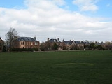
, still of considerable size, was once even bigger and old maps show it stretching as far as the tennis courts and up the west side of the A68 to behind the Kennels and across the cricket pitch. Originally common pasture land, its size and uses have changed from time to time and it has been used for sports, games, picnics, festivities and even military encampment.
Perhaps the best known use of the Green is the historic St Boswells Fair which is held on the 18 July every year. The fair used to be held on the flat haugh below Benrig but in 1743 the river level rose as a result of heavy rains and the Fair was flooded. With wet feet but undampened spirits, a decision was made to move the venue to the Green, and it has been held there ever since. Originally a sheep fair and a wool
Wool
Wool is the textile fiber obtained from sheep and certain other animals, including cashmere from goats, mohair from goats, qiviut from muskoxen, vicuña, alpaca, camel from animals in the camel family, and angora from rabbits....
market, it came to be a selling point for cattle and horses. It was not uncommon for a thousand horses to change hands over the period of the Fair. Gypsies came in their brightly decorated wagons from other parts of Scotland, England and even Ireland. It was a time for merriment and fun making, with kiosks, booths and campfires offering a change from daily routine for local residents. The tradition continues and the Fair is still held on the same date every year, but in a greatly reduced form.
The civic awareness which inspired the planting of trees on the Green to commemorate events such as Queen Victoria's Diamond Jubilee, the Boer War
Boer War
The Boer Wars were two wars fought between the British Empire and the two independent Boer republics, the Oranje Vrijstaat and the Republiek van Transvaal ....
, the coronation of George V
George V of the United Kingdom
George V was King of the United Kingdom and the British Dominions, and Emperor of India, from 6 May 1910 through the First World War until his death in 1936....
and the Buccleuch Golden Wedding has given us a pleasant place to walk and think and be at peace.
The war years saw much activity in the village and the area was virtually taken over by the Army for various uses. There was a munitions factory at Charlesfield. Stores and fuel dumps were round every corner. The soldiers, many of whom were billeted in the Kennels, had support from the Home Guard, air raid wardens and voluntary ambulance drivers. Canteen facilities and first aid were provided by local organisations. Residents of the village, men and women, young and old, were united in their support of the war effort.
The River Tweed
It is not possible to speak of St Boswells village without thinking of the river which bends and twists on its swift flowing course north of the village. Famous for its salmon and brown troutTrout
Trout is the name for a number of species of freshwater and saltwater fish belonging to the Salmoninae subfamily of the family Salmonidae. Salmon belong to the same family as trout. Most salmon species spend almost all their lives in salt water...
it has given satisfaction to anglers over the years. Many of the local houses were built of stones from the river bed. The riverside walks are at all times pleasant and sometimes spectacular. Walkers on St Cuthbert's Way through the village on pilgrimage from Melrose to Lindisfarne
Lindisfarne
Lindisfarne is a tidal island off the north-east coast of England. It is also known as Holy Island and constitutes a civil parish in Northumberland...
see the same view of the Eildon Hills as was seen by such men as Modan who established a religious cell at Dryburgh; Aidan who brought twelve young monks from Lindisfarne to Old Melrose as missionaries; Cuthbert who became prior and bishop and Boisil who, after a life of holiness and healing gave his name to the village and parish of St Boswells.
Sports
St Boswells is one of the Borders' more active villages regarding organised sport.Perhaps unusually for Scotland, part of the Green was given over to cricket
Cricket
Cricket is a bat-and-ball game played between two teams of 11 players on an oval-shaped field, at the centre of which is a rectangular 22-yard long pitch. One team bats, trying to score as many runs as possible while the other team bowls and fields, trying to dismiss the batsmen and thus limit the...
. The present Club was constituted in 1895 and the current pitch, a gift from the Duke of Buccleuch
Duke of Buccleuch
The title Duke of Buccleuch , formerly also spelt Duke of Buccleugh, was created in the Peerage of Scotland on 20 April 1663 for the Duke of Monmouth, who was the eldest illegitimate son of Charles II of Scotland, England, and Ireland and who had married Anne Scott, 4th Countess of Buccleuch.Anne...
used since the 1920s. About the same time the Curling
Curling
Curling is a sport in which players slide stones across a sheet of ice towards a target area. It is related to bowls, boule and shuffleboard. Two teams, each of four players, take turns sliding heavy, polished granite stones, also called "rocks", across the ice curling sheet towards the house, a...
Club was also formed. Using water from the Laret Burn, a pond was constructed just beyond the Green just about where the tennis courts now stand. Perhaps the winters really were more severe in days gone past because ice did form and games went ahead. Trees were planted at strategic points to prevent the sun's rays melting the ice. The pond was closed in 1964 and the club moved to Kelso indoor rink.
The cricket team has seen the most success having a brief spell in the national league in 2006 and winning the Border League four times between 2004 and 2008. The football and rugby team haven't seen similar fortune, though - both clubs finishing bottom of their respective leagues in the 2005-06 season. A comprehensive list of the St Boswells sports clubs is given below.
- Golf Club
- Tennis Club
- Model Boat Club
- Amateur Football Club
- Junior Football Club
- Cricket Club
- Badminton Clubs (Monday, Tuesday and Thursday)
- Curling Club
- Rugby Football Club
- List of places in the Scottish Borders
- List of places in East Lothian
- List of places in Midlothian
Sources of information
- Original History, Lessuden, Village Life, The River Tweed, Employment and some Sports material prepared by Murial Ovens, St Boswells, Scotland and reproduced with her kind permission.