
Shropshire Hills AONB
Encyclopedia
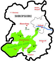
The Shropshire Hills area is designated as an Area of Outstanding Natural Beauty
(AONB), in the English
county of Shropshire
, close to its border with Wales
. Designated in 1958 http://www.shrewsbury.gov.uk/public/council/committees/cabinet/2004-03-01/aonb+-+executive+summary2.doc, the area encompasses 802 square kilometres (309.7 sq mi) of land primarily in south-west Shropshire. The A49 road
and Welsh Marches Railway Line
bisects the area north-south, passing through or near Shrewsbury
, Church Stretton
, Craven Arms
and Ludlow
.


, are relatively high, with the highest point in the county, Brown Clee Hill
, near Ludlow
, towering to a height of 540 metre. This gives Shropshire the 13th tallest hill per county in England. Titterstone Clee Hill
, part of the Clee Hills
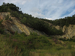
, is of a similar height to Brown Clee, at 533 metres (1,749 ft), making it the third largest hill. The Stiperstones
are the second largest in the county, at 536 metres (1,759 ft), and are notable for their tors of quartzite
; particularly notable are Devil's Chair and Shepherd's Rock .
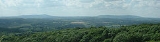
More accessible hills are the Long Mynd
, which covers an area of 5,436 acres (8½ square miles) and peaking at Pole Bank at a height of 516 metres (1,693 feet), is located near Church Stretton
. It contains Carding Mill Valley, a popular recreational area which was developed as a honeypot
to draw tourists away from the more sensitive/protected areas of the Mynd. The Wrekin
(407 metres (1,335 ft)), located in the far northeastern panhandle
of the AONB, is an extremely popular hill with a well-used trail. Located near to Wellington
, its position close to the major population centres of Shropshire, and good transport links (A5/M54
) make it easy to access. Ercall Hill, a notable geological site, is located just to the north of The Wrekin.
Other prominent hills include Corndon Hill
, the summit of which is in Wales
, and Lyth Hill, which is located to the south of Shrewsbury
near Bayston Hill
.
(sometimes known as "Little Switzerland
"), which has a population of approximately 3,000.
Development has shifted south to Craven Arms
, which is located just outside the development restriction boundaries, and is where the Shropshire Hills AONB Partnership is based.
Clun
is a small town of less than 1,000 located in the east, in the Clun Valley, and is the only other town (apart from Church Stretton) within the boundaries of the AONB.
Ludlow
is regionally the largest town, near to the AONB.
Bishop's Castle
is a small town of approximately 1,500, which is located in a niche near the Welsh border to the west. Bucknell
is a notable village in the south.
area. Its northeasternmost extremity, in the vicinity of the prominent Wrekin
hill, is located in the borough of Telford & Wrekin.
(near Craven Arms
), a well-preserved fortified manor house
.
Ludlow Castle
in Ludlow was constructed in the 11th Century as the border stronghold of one of the Marcher Lords
, Roger de Lacy
.
Offa's Dyke
, a massive linear earthwork, also runs through the area, and across the Clun Valley area.
Clun Castle
is located near Clun.
Area of Outstanding Natural Beauty
An Area of Outstanding Natural Beauty is an area of countryside considered to have significant landscape value in England, Wales or Northern Ireland, that has been specially designated by the Countryside Agency on behalf of the United Kingdom government; the Countryside Council for Wales on...
(AONB), in the English
England
England is a country that is part of the United Kingdom. It shares land borders with Scotland to the north and Wales to the west; the Irish Sea is to the north west, the Celtic Sea to the south west, with the North Sea to the east and the English Channel to the south separating it from continental...
county of Shropshire
Shropshire
Shropshire is a county in the West Midlands region of England. For Eurostat purposes, the county is a NUTS 3 region and is one of four counties or unitary districts that comprise the "Shropshire and Staffordshire" NUTS 2 region. It borders Wales to the west...
, close to its border with Wales
Wales
Wales is a country that is part of the United Kingdom and the island of Great Britain, bordered by England to its east and the Atlantic Ocean and Irish Sea to its west. It has a population of three million, and a total area of 20,779 km²...
. Designated in 1958 http://www.shrewsbury.gov.uk/public/council/committees/cabinet/2004-03-01/aonb+-+executive+summary2.doc, the area encompasses 802 square kilometres (309.7 sq mi) of land primarily in south-west Shropshire. The A49 road
A49 road
The A49 is a major road in western England, which traverses the Welsh Marches region. It runs north from Ross-on-Wye in Herefordshire via Hereford, Leominster, Ludlow, Shrewsbury and Whitchurch, then continues through central Cheshire to Warrington and Wigan before terminating at its junction with...
and Welsh Marches Railway Line
Welsh Marches Line
The Welsh Marches Line , known historically as the North and West Route, is the railway line running from Newport in south-east Wales to Shrewsbury in the West Midlands region of England by way of Abergavenny, Hereford and Craven Arms, and thence to Crewe via Whitchurch...
bisects the area north-south, passing through or near Shrewsbury
Shrewsbury
Shrewsbury is the county town of Shropshire, in the West Midlands region of England. Lying on the River Severn, it is a civil parish home to some 70,000 inhabitants, and is the primary settlement and headquarters of Shropshire Council...
, Church Stretton
Church Stretton
Church Stretton is a small town and civil parish in Shropshire, England. The population of the town was recorded as 2,789 in 2001, whilst the population of the wider parish was recorded as 4,186...
, Craven Arms
Craven Arms
Craven Arms is a small town and civil parish in Shropshire, England, located on the A49 road and the Welsh Marches railway line, which connect it north and south to the larger towns of Shrewsbury and Ludlow respectively. The Heart of Wales railway line joins the Welsh Marches line at Craven Arms...
and Ludlow
Ludlow
Ludlow is a market town in Shropshire, England close to the Welsh border and in the Welsh Marches. It lies within a bend of the River Teme, on its eastern bank, forming an area of and centred on a small hill. Atop this hill is the site of Ludlow Castle and the market place...
.
Hills
The Shropshire Hills, located in the Welsh MarchesWelsh Marches
The Welsh Marches is a term which, in modern usage, denotes an imprecisely defined area along and around the border between England and Wales in the United Kingdom. The precise meaning of the term has varied at different periods...
, are relatively high, with the highest point in the county, Brown Clee Hill
Brown Clee Hill
Brown Clee Hill is the highest hill in the rural English county of Shropshire, at 540 metres above sea level. It is one of the Clee Hills, and is in the Shropshire Hills Area of Outstanding Natural Beauty.-Geography:...
, near Ludlow
Ludlow
Ludlow is a market town in Shropshire, England close to the Welsh border and in the Welsh Marches. It lies within a bend of the River Teme, on its eastern bank, forming an area of and centred on a small hill. Atop this hill is the site of Ludlow Castle and the market place...
, towering to a height of 540 metre. This gives Shropshire the 13th tallest hill per county in England. Titterstone Clee Hill
Titterstone Clee Hill
Titterstone Clee Hill, sometimes referred to as Clee Hill or Titterstone Clee, is a hill in the rural English county of Shropshire, rising at the summit to 533 m above sea level....
, part of the Clee Hills
Clee Hills
The Clee Hills are a range of hills in Shropshire, England near Ludlow, consisting of Brown Clee Hill , the highest peak in Shropshire, and Titterstone Clee Hill...
, is of a similar height to Brown Clee, at 533 metres (1,749 ft), making it the third largest hill. The Stiperstones
Stiperstones
The Stiperstones is a very distinctive hill in the county of Shropshire, England. It is a quartzite ridge formed some 480 Million years ago. During the last Ice Age the summit stood out above the glaciers and was subject to constant freezing and thawing which shattered the quartzite into a mass of...
are the second largest in the county, at 536 metres (1,759 ft), and are notable for their tors of quartzite
Quartzite
Quartzite is a hard metamorphic rock which was originally sandstone. Sandstone is converted into quartzite through heating and pressure usually related to tectonic compression within orogenic belts. Pure quartzite is usually white to gray, though quartzites often occur in various shades of pink...
; particularly notable are Devil's Chair and Shepherd's Rock .
More accessible hills are the Long Mynd
Long Mynd
The Long Mynd in Shropshire, England, is a part of the Shropshire Hills Area of Outstanding Natural Beauty. It is south of the county town Shrewsbury, and has an area of over 22 square kilometres , most of which takes the form of a heathland plateau. Most of the land on the Long Mynd is owned by...
, which covers an area of 5,436 acres (8½ square miles) and peaking at Pole Bank at a height of 516 metres (1,693 feet), is located near Church Stretton
Church Stretton
Church Stretton is a small town and civil parish in Shropshire, England. The population of the town was recorded as 2,789 in 2001, whilst the population of the wider parish was recorded as 4,186...
. It contains Carding Mill Valley, a popular recreational area which was developed as a honeypot
Honeypot (geography)
In geography, a honeypot is a particularly popular visitor attraction which attracts tourists in large numbers. The term 'honeypot' originates from bees buzzing around a hive.-Tourism planning:...
to draw tourists away from the more sensitive/protected areas of the Mynd. The Wrekin
The Wrekin
The Wrekin is a hill in east Shropshire, England. It is located some west of Telford, on the border between the unitary authorities of Shropshire and Telford and Wrekin. Rising to a height of above the Shropshire Plain, it is a prominent and well-known landmark, marking the entrance to Shropshire...
(407 metres (1,335 ft)), located in the far northeastern panhandle
Panhandle
A panhandle is an informal geographic term for an elongated arm-like protrusion of a geo-political entity, such as a subnational entity or a sovereign state.-Term:...
of the AONB, is an extremely popular hill with a well-used trail. Located near to Wellington
Wellington, Shropshire
Wellington is a town in the unitary authority of Telford and Wrekin and ceremonial county of Shropshire, England and now forms part of the new town of Telford. The population of the parish of Wellington was recorded as 20,430 in the 2001 census, making it the third largest town in Shropshire if...
, its position close to the major population centres of Shropshire, and good transport links (A5/M54
M54 motorway
The M54 is a 23 mile east-west motorway in the English counties of Shropshire and Staffordshire. It is also referred to as the Telford Motorway, after the road's primary westbound destination, the new town of Telford...
) make it easy to access. Ercall Hill, a notable geological site, is located just to the north of The Wrekin.
Other prominent hills include Corndon Hill
Corndon Hill
Corndon Hill is a hill in Powys, Mid Wales, whose summit rises to 513 m above sea level.It is surrounded on three sides by the English county of Shropshire and forms a prominent landmark in the Wales-England border...
, the summit of which is in Wales
Wales
Wales is a country that is part of the United Kingdom and the island of Great Britain, bordered by England to its east and the Atlantic Ocean and Irish Sea to its west. It has a population of three million, and a total area of 20,779 km²...
, and Lyth Hill, which is located to the south of Shrewsbury
Shrewsbury
Shrewsbury is the county town of Shropshire, in the West Midlands region of England. Lying on the River Severn, it is a civil parish home to some 70,000 inhabitants, and is the primary settlement and headquarters of Shropshire Council...
near Bayston Hill
Bayston Hill
Bayston Hill is a large village and civil parish in central Shropshire, England. It is south of the county town Shrewsbury and located on the main A49 road, the Shrewsbury to Hereford road....
.
Towns & Villages
The largest town within the AONB is Church StrettonChurch Stretton
Church Stretton is a small town and civil parish in Shropshire, England. The population of the town was recorded as 2,789 in 2001, whilst the population of the wider parish was recorded as 4,186...
(sometimes known as "Little Switzerland
Switzerland
Switzerland name of one of the Swiss cantons. ; ; ; or ), in its full name the Swiss Confederation , is a federal republic consisting of 26 cantons, with Bern as the seat of the federal authorities. The country is situated in Western Europe,Or Central Europe depending on the definition....
"), which has a population of approximately 3,000.
Development has shifted south to Craven Arms
Craven Arms
Craven Arms is a small town and civil parish in Shropshire, England, located on the A49 road and the Welsh Marches railway line, which connect it north and south to the larger towns of Shrewsbury and Ludlow respectively. The Heart of Wales railway line joins the Welsh Marches line at Craven Arms...
, which is located just outside the development restriction boundaries, and is where the Shropshire Hills AONB Partnership is based.
Clun
Clun
Clun is a small town in Shropshire, England. The town is located entirely in the Shropshire Hills Area of Outstanding Natural Beauty. The 2001 census recorded 642 people living in the town...
is a small town of less than 1,000 located in the east, in the Clun Valley, and is the only other town (apart from Church Stretton) within the boundaries of the AONB.
Ludlow
Ludlow
Ludlow is a market town in Shropshire, England close to the Welsh border and in the Welsh Marches. It lies within a bend of the River Teme, on its eastern bank, forming an area of and centred on a small hill. Atop this hill is the site of Ludlow Castle and the market place...
is regionally the largest town, near to the AONB.
Bishop's Castle
Bishop's Castle
Bishop's Castle is a small market town in Shropshire, England, and formerly its smallest borough. According to the 2001 census it had a population of 1,630. Bishop's Castle is east of the Wales-England border, about north-west of Ludlow and about south-west of Shrewsbury. To the south is Clun...
is a small town of approximately 1,500, which is located in a niche near the Welsh border to the west. Bucknell
Bucknell, Shropshire
Bucknell is a village and civil parish in Shropshire, England. The village lies on the River Redlake, within 600 metres of the River Teme and close to the borders with Wales and Herefordshire...
is a notable village in the south.
Local Authorities
The AONB falls largely within the Shropshire CouncilShropshire Council
Shropshire Council is a unitary authority in Shropshire, United Kingdom.It replaced the former two-tier local government structure in the non-metropolitan county of Shropshire on 1 April 2009, which involved its immediate predecessor, Shropshire County Council, and five non-metropolitan districts -...
area. Its northeasternmost extremity, in the vicinity of the prominent Wrekin
The Wrekin
The Wrekin is a hill in east Shropshire, England. It is located some west of Telford, on the border between the unitary authorities of Shropshire and Telford and Wrekin. Rising to a height of above the Shropshire Plain, it is a prominent and well-known landmark, marking the entrance to Shropshire...
hill, is located in the borough of Telford & Wrekin.
Rivers
- River ClunRiver Clun, ShropshireThe River Clun is a river in Shropshire, England which runs through the small town of Clun, as well as Newcastle-on-Clun and other villages. It meets the River Teme at Leintwardine, Herefordshire....
- starting at AnchorAnchor, ShropshireAnchor is a remote hamlet in Shropshire, England, located at . The hamlet is the most westerly place in Shropshire.-Geography:Anchor lies only 400m away from the border with Wales. The B4368 road runs through the hamlet on its way between the towns of Clun to Newtown...
, ends up joining the Teme - Cound BrookCound BrookCound Brook is a tributary of the River Severn in Shropshire, England, running to south of the county town Shrewsbury. The Cound Brook rises in the Stretton Hills and discharges into the River Severn at Eyton on Severn after winding its way for across the southern Shropshire-Severn plains.The flow...
- Rises from minor watercourses running off the Long Mynd and Caer Caradoc before discharging into the River SevernRiver SevernThe River Severn is the longest river in Great Britain, at about , but the second longest on the British Isles, behind the River Shannon. It rises at an altitude of on Plynlimon, Ceredigion near Llanidloes, Powys, in the Cambrian Mountains of mid Wales... - River TemeRiver TemeThe River Teme rises in Mid Wales, south of Newtown in Powys, and flows through Knighton where it crosses the border into England down to Ludlow in Shropshire, then to the north of Tenbury Wells on the Shropshire/Worcestershire border there, on its way to join the River Severn south of Worcester...
- flows through Ludlow, before passing into HerefordshireHerefordshireHerefordshire is a historic and ceremonial county in the West Midlands region of England. For Eurostat purposes it is a NUTS 3 region and is one of three counties that comprise the "Herefordshire, Worcestershire and Gloucestershire" NUTS 2 region. It also forms a unitary district known as the... - River ReaRiver Rea, ShropshireThe River Rea is a small river that flows through south east Shropshire, England and passes just to the east of the small market town of Cleobury Mortimer, before entering the Teme at Newnham Bridge in Worcestershire. Its waters eventually reach the Bristol Channel, via the Severn. The upper...
- flows north to south, passes through Cleobury Mortimer
Historical Attractions
Attractions of historical interest located within or near the AONB include Stokesay CastleStokesay Castle
Stokesay Castle is a fortified manor house in Stokesay, a mile south of the town of Craven Arms, in southern Shropshire. It was built in the late 13th century...
(near Craven Arms
Craven Arms
Craven Arms is a small town and civil parish in Shropshire, England, located on the A49 road and the Welsh Marches railway line, which connect it north and south to the larger towns of Shrewsbury and Ludlow respectively. The Heart of Wales railway line joins the Welsh Marches line at Craven Arms...
), a well-preserved fortified manor house
Manor house
A manor house is a country house that historically formed the administrative centre of a manor, the lowest unit of territorial organisation in the feudal system in Europe. The term is applied to country houses that belonged to the gentry and other grand stately homes...
.
Ludlow Castle
Ludlow Castle
Ludlow Castle is a large, partly ruined, non-inhabited castle which dominates the town of Ludlow in Shropshire, England. It stands on a high point overlooking the River Teme...
in Ludlow was constructed in the 11th Century as the border stronghold of one of the Marcher Lords
Marcher Lords
A Marcher Lord was a strong and trusted noble appointed by the King of England to guard the border between England and Wales.A Marcher Lord is the English equivalent of a margrave...
, Roger de Lacy
Roger de Lacy
Roger de Lacy, was an Anglo-Norman nobleman, a Marcher Lord on the Welsh border.- Lineage :He was son of Walter de Lacy , a retainer of William fitzOsbern. Roger was a castle builder, particularly at Ludlow Castle....
.
Offa's Dyke
Offa's Dyke
Offa's Dyke is a massive linear earthwork, roughly followed by some of the current border between England and Wales. In places, it is up to wide and high. In the 8th century it formed some kind of delineation between the Anglian kingdom of Mercia and the Welsh kingdom of Powys...
, a massive linear earthwork, also runs through the area, and across the Clun Valley area.
Clun Castle
Clun Castle
Clun Castle is a ruined castle in the small town of Clun, Shropshire. Clun Castle was established by the Norman lord Robert de Say after the invasion and went on to become an important Marcher lord castle in the 12th century, with an extensive castle-guard system...
is located near Clun.
Wildlife
- Peregrine FalconPeregrine FalconThe Peregrine Falcon , also known as the Peregrine, and historically as the Duck Hawk in North America, is a widespread bird of prey in the family Falconidae. A large, crow-sized falcon, it has a blue-gray back, barred white underparts, and a black head and "moustache"...
- DipperWhite-throated DipperThe White-throated Dipper , also known as the European Dipper or just Dipper is an aquatic passerine bird found in Europe, Middle East, Central Asia and the Indian Subcontinent. The species is divided into several subspecies, based primarily on colour differences, particularly of the pectoral band...
- Ring OuzelRing OuzelThe Ring Ouzel is a European member of the thrush family Turdidae.It is the mountain equivalent of the closely related Common Blackbird, and breeds in gullies, rocky areas or scree slopes....
- MerlinMerlin (bird)The Merlin is a small species of falcon from the Northern Hemisphere. A bird of prey once known colloquially as a pigeon hawk in North America, the Merlin breeds in the northern Holarctic; some migrate to subtropical and northern tropical regions in winter.-European and North American...
- CurlewEurasian CurlewThe Eurasian Curlew, Numenius arquata, is a wader in the large family Scolopacidae. It is one of the most widespread of the curlews, breeding across temperate Europe and Asia...
- Tree SparrowTree SparrowThe Eurasian Tree Sparrow is a passerine bird in the sparrow family with a rich chestnut crown and nape, and a black patch on each pure white cheek. The sexes are similarly plumaged, and young birds are a duller version of the adult...
- Pied Flycatcher
- Barn OwlBarn OwlThe Barn Owl is the most widely distributed species of owl, and one of the most widespread of all birds. It is also referred to as Common Barn Owl, to distinguish it from other species in the barn-owl family Tytonidae. These form one of two main lineages of living owls, the other being the typical...
- Red FoxRed FoxThe red fox is the largest of the true foxes, as well as being the most geographically spread member of the Carnivora, being distributed across the entire northern hemisphere from the Arctic Circle to North Africa, Central America, and the steppes of Asia...
- BadgerEurasian BadgerThe European Badger is a species of badger of the genus Meles, native to almost all of Europe. It is classed as Least Concern for extinction by the IUCN, due to its wide distribution and large population....
- Red GrouseRed grouseThe Red Grouse is a medium sized bird of the grouse family which is found in heather moorland in Great Britain and Ireland. It is usually classified as a subspecies of the Willow Grouse but is sometimes considered to be a separate species Lagopus scoticus...
- Turtle DoveTurtle DoveThe European Turtle Dove , also known as Turtle Dove, is a member of the bird family Columbidae, which includes the doves and pigeons.-Distribution & Status:...
- BuzzardCommon BuzzardThe Common Buzzard is a medium to large bird of prey, whose range covers most of Europe and extends into Asia. It is usually resident all year, except in the coldest parts of its range, and in the case of one subspecies.-Description:...
- Common SnipeCommon SnipeThe Common Snipe is a small, stocky wader native to the Old World. The breeding habitat is marshes, bogs, tundra and wet meadows throughout northern Europe and northern Asia...
- Northern LapwingNorthern LapwingThe Northern Lapwing , also known as the Peewit, Green Plover or just Lapwing, is a bird in the plover family. It is common through temperate Eurasia....
- Common RedshankCommon RedshankThe Common Redshank or simply Redshank is an Eurasian wader in the large family Scolopacidae.- Description and systematics :...
Other Attractions
- Clun ForestClun ForestClun Forest is a remote, rural area of open pastures, moorland and mixed deciduous/coniferous woodland in the southwest part of the English county of Shropshire and also just over the border into Powys, Wales....
- remote area of woodland and hills - Wyre ForestWyre ForestWyre Forest is a large, semi-natural woodland and forest which straddles the borders of Worcestershire and Shropshire, England.The Wyre Forest district of Worcestershire takes its name from the forest, despite the fact that much of the woodland does not lie within the district's boundaries, but...
- large woodlandWoodlandEcologically, a woodland is a low-density forest forming open habitats with plenty of sunlight and limited shade. Woodlands may support an understory of shrubs and herbaceous plants including grasses. Woodland may form a transition to shrubland under drier conditions or during early stages of...
, half of which is in Shropshire, the other half in WorcestershireWorcestershireWorcestershire is a non-metropolitan county, established in antiquity, located in the West Midlands region of England. For Eurostat purposes it is a NUTS 3 region and is one of three counties that comprise the "Herefordshire, Worcestershire and Warwickshire" NUTS 2 region...