
Wyre Forest
Overview
Woodland
Ecologically, a woodland is a low-density forest forming open habitats with plenty of sunlight and limited shade. Woodlands may support an understory of shrubs and herbaceous plants including grasses. Woodland may form a transition to shrubland under drier conditions or during early stages of...
and forest
Forest
A forest, also referred to as a wood or the woods, is an area with a high density of trees. As with cities, depending where you are in the world, what is considered a forest may vary significantly in size and have various classification according to how and what of the forest is composed...
which straddles the borders of Worcestershire
Worcestershire
Worcestershire is a non-metropolitan county, established in antiquity, located in the West Midlands region of England. For Eurostat purposes it is a NUTS 3 region and is one of three counties that comprise the "Herefordshire, Worcestershire and Warwickshire" NUTS 2 region...
and Shropshire
Shropshire
Shropshire is a county in the West Midlands region of England. For Eurostat purposes, the county is a NUTS 3 region and is one of four counties or unitary districts that comprise the "Shropshire and Staffordshire" NUTS 2 region. It borders Wales to the west...
, England
England
England is a country that is part of the United Kingdom. It shares land borders with Scotland to the north and Wales to the west; the Irish Sea is to the north west, the Celtic Sea to the south west, with the North Sea to the east and the English Channel to the south separating it from continental...
.
The Wyre Forest district
Wyre Forest (district)
This article is about the local government district in WorcestershireWyre Forest is a local government district in Worcestershire, England, covering the towns of Kidderminster, Stourport-on-Severn and Bewdley, and several civil parishes and their villages...
of Worcestershire takes its name from the forest, despite the fact that much of the woodland does not lie within the district's boundaries, but rather in Shropshire.
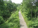
The forest covers an area of 2,634 hectare
Hectare
The hectare is a metric unit of area defined as 10,000 square metres , and primarily used in the measurement of land. In 1795, when the metric system was introduced, the are was defined as being 100 square metres and the hectare was thus 100 ares or 1/100 km2...
s (6,509 acre
Acre
The acre is a unit of area in a number of different systems, including the imperial and U.S. customary systems. The most commonly used acres today are the international acre and, in the United States, the survey acre. The most common use of the acre is to measure tracts of land.The acre is related...
s), and is noted for its variety of wildlife
Wildlife
Wildlife includes all non-domesticated plants, animals and other organisms. Domesticating wild plant and animal species for human benefit has occurred many times all over the planet, and has a major impact on the environment, both positive and negative....
. Although now the Wyre Forest has been much deforested, it still extends from east of the A442
A442 road
The A442 is a main road which passes through the counties of Worcestershire and Shropshire, in the West Midlands region of England.-Route:From Droitwich in Worcestershire it runs towards Kidderminster where it meets the A449 from Worcester...
at Shatterford, north of Kidderminster
Kidderminster
Kidderminster is a town, in the Wyre Forest district of Worcestershire, England. It is located approximately seventeen miles south-west of Birmingham city centre and approximately fifteen miles north of Worcester city centre. The 2001 census recorded a population of 55,182 in the town...
in the east, almost to Cleobury Mortimer
Cleobury Mortimer
Cleobury Mortimer is a small rural market town in Shropshire, England. The town's parish has a population of 1,962 according to the 2001 census. Although sometimes regarded as a village, it is in fact the second smallest town in Shropshire , having been granted a town charter in 1253.Several...
in the west and from Upper Arley
Upper Arley
Upper Arley is a village is a village and civil parish near Kidderminster in the Wyre Forest District of Worcestershire, England. At the 2001 census it had a population of 645.- Amenities :...
in the north to Areley Kings
Areley Kings
Areley Kings is a Worcestershire village on the River Severn 10 miles north of Worcester in the picturesque area of the Wyre Forest. The area is featured in the Domesday Book and many historical places of interest are open to visitors...
, near Stourport
Stourport-on-Severn
Stourport-on-Severn, often shortened to Stourport, is a town and civil parish in the Wyre Forest District of North Worcestershire, England, a few miles to the south of Kidderminster and down stream on the River Severn from Bewdley...
in the south.