

Shropshire Council
Encyclopedia
| Shropshire Council | |
|---|---|
Shropshire Council logo Motto: Floreat Salopia |
|
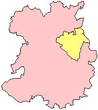 Shropshire unitary authority area (pink) in the ceremonial and historic Historic counties of England The historic counties of England are subdivisions of England established for administration by the Normans and in most cases based on earlier Anglo-Saxon kingdoms and shires... county of Shropshire |
|
| Geography | |
| Status: | Unitary authority Unitary authority A unitary authority is a type of local authority that has a single tier and is responsible for all local government functions within its area or performs additional functions which elsewhere in the relevant country are usually performed by national government or a higher level of sub-national... |
| Origin: | 2009 structural changes 2009 structural changes to local government in England Structural changes to local government in England were effected on 1 April 2009, whereby a number of new unitary authorities were created in parts of the country which previously operated a 'two-tier' system of counties and districts... |
| Region Regions of England In England, the region is the highest tier of sub-national division used by central Government. Between 1994 and 2011, the nine regions had an administrative role in the implementation of UK Government policy, and as the areas covered by elected bodies... : |
West Midlands West Midlands (region) The West Midlands is an official region of England, covering the western half of the area traditionally known as the Midlands. It contains the second most populous British city, Birmingham, and the larger West Midlands conurbation, which includes the city of Wolverhampton and large towns of Dudley,... |
| Ceremonial County Ceremonial counties of England The ceremonial counties are areas of England to which are appointed a Lord Lieutenant, and are defined by the government as counties and areas for the purposes of the Lieutenancies Act 1997 with reference to the metropolitan and non-metropolitan counties of England and Lieutenancies Act 1997... : |
Shropshire Shropshire Shropshire is a county in the West Midlands region of England. For Eurostat purposes, the county is a NUTS 3 region and is one of four counties or unitary districts that comprise the "Shropshire and Staffordshire" NUTS 2 region. It borders Wales to the west... |
| Area Surface area Surface area is the measure of how much exposed area a solid object has, expressed in square units. Mathematical description of the surface area is considerably more involved than the definition of arc length of a curve. For polyhedra the surface area is the sum of the areas of its faces... : - Total - Rank |
3,197 km² / 1,234 mi² 4th |
| Admin. HQ: | Shrewsbury Shrewsbury Shrewsbury is the county town of Shropshire, in the West Midlands region of England. Lying on the River Severn, it is a civil parish home to some 70,000 inhabitants, and is the primary settlement and headquarters of Shropshire Council... |
| ONS code ONS coding system In the United Kingdom, the Office for National Statistics maintains a series of codes to represent a wide range of geographical areas of the UK, for use in tabulating census and other statistical data... : |
00GG |
| NUTS code Nomenclature of Territorial Units for Statistics The Nomenclature of Territorial Units for Statistics or Nomenclature of Units for Territorial Statistics is a geocode standard for referencing the subdivisions of countries for statistical purposes... : |
UKG22 |
| ISO code ISO 3166-2:GB ISO 3166-2:GB is the entry for the United Kingdom in ISO 3166-2, part of the ISO 3166 standard published by the International Organization for Standardization , which defines codes for the names of the principal subdivisions of all countries coded in ISO 3166-1.Currently for the United Kingdom,... : |
GB-SHR |
| Demographics | |
| Population Population A population is all the organisms that both belong to the same group or species and live in the same geographical area. The area that is used to define a sexual population is such that inter-breeding is possible between any pair within the area and more probable than cross-breeding with individuals... : - Total - Rank - Density Population density Population density is a measurement of population per unit area or unit volume. It is frequently applied to living organisms, and particularly to humans... |
90.99 / km² |
| Ethnicity: | 97.3% White 1.2% S.Asian |
| Politics | |
| Shropshire Council http://www.shropshire.gov.uk/ |
|
| Leadership: | Leader & Cabinet |
| Executive: | Conservative Conservative Party (UK) The Conservative Party, formally the Conservative and Unionist Party, is a centre-right political party in the United Kingdom that adheres to the philosophies of conservatism and British unionism. It is the largest political party in the UK, and is currently the largest single party in the House... |
| MPs: |
|
Shropshire Council is a unitary authority
Unitary authority
A unitary authority is a type of local authority that has a single tier and is responsible for all local government functions within its area or performs additional functions which elsewhere in the relevant country are usually performed by national government or a higher level of sub-national...
in Shropshire
Shropshire
Shropshire is a county in the West Midlands region of England. For Eurostat purposes, the county is a NUTS 3 region and is one of four counties or unitary districts that comprise the "Shropshire and Staffordshire" NUTS 2 region. It borders Wales to the west...
, United Kingdom
United Kingdom
The United Kingdom of Great Britain and Northern IrelandIn the United Kingdom and Dependencies, other languages have been officially recognised as legitimate autochthonous languages under the European Charter for Regional or Minority Languages...
.
It replaced the former two-tier local government structure in the non-metropolitan county of Shropshire on 1 April 2009, which involved its immediate predecessor, Shropshire County Council
County council
A county council is the elected administrative body governing an area known as a county. This term has slightly different meanings in different countries.-United Kingdom:...
, and five non-metropolitan districts - Bridgnorth
Bridgnorth (district)
Bridgnorth District was, between 1974 and 2009, a local government district in Shropshire, England. Its main town was Bridgnorth and other towns in its area were Much Wenlock, Shifnal and Broseley. The villages of Albrighton and Sheriffhales as well as RAF Cosford were also in the district.The...
, North Shropshire
North Shropshire
North Shropshire was a local government district in Shropshire, England. The district council was based at Edinburgh House, in Wem. Other settlements included the towns of Ellesmere, Market Drayton, Wem and Whitchurch, as well as the large villages of Shawbury and Baschurch...
, Oswestry
Oswestry (borough)
Oswestry was a small local government district with borough status in Shropshire, England. It was the smallest of the five districts of Shropshire in terms of both population and land area....
, South Shropshire
South Shropshire
South Shropshire was, between 1974 and 2009, a local government district in south west Shropshire, England.South Shropshire was the most rural district of one of the UK's most rural counties, the population of the district was 40,410 in 2001 spread out over 1,027 km² of forest, mountains,...
and Shrewsbury & Atcham
Shrewsbury and Atcham
Shrewsbury and Atcham was, between 1974 and 2009, a local government district with borough status in Shropshire, England.Shrewsbury was the only town in the borough; Atcham, although itself only a village, was included in the name as a reflection of the incorporation into the borough of the former...
. These districts and their councils were abolished in the reorganisation.
The area covered by Shropshire Council is 3,197 square kilometres, or 1,234 square miles. This is 91.7% of the ceremonial county
Ceremonial counties of England
The ceremonial counties are areas of England to which are appointed a Lord Lieutenant, and are defined by the government as counties and areas for the purposes of the Lieutenancies Act 1997 with reference to the metropolitan and non-metropolitan counties of England and Lieutenancies Act 1997...
of Shropshire, with the remainder being covered by the other unitary authority in Shropshire, Telford and Wrekin
Telford and Wrekin
Telford and Wrekin is a unitary district with borough status in the West Midlands region of England. For Eurostat purposes it is a NUTS 3 region and is one of four counties or unitary districts that comprise the "Shropshire and Staffordshire" NUTS 2 region. The district was created in 1974 as The...
Borough Council, which was established as a unitary authority in 1998. Shropshire is located in the West Midlands
West Midlands (region)
The West Midlands is an official region of England, covering the western half of the area traditionally known as the Midlands. It contains the second most populous British city, Birmingham, and the larger West Midlands conurbation, which includes the city of Wolverhampton and large towns of Dudley,...
region
Regions of England
In England, the region is the highest tier of sub-national division used by central Government. Between 1994 and 2011, the nine regions had an administrative role in the implementation of UK Government policy, and as the areas covered by elected bodies...
of England
England
England is a country that is part of the United Kingdom. It shares land borders with Scotland to the north and Wales to the west; the Irish Sea is to the north west, the Celtic Sea to the south west, with the North Sea to the east and the English Channel to the south separating it from continental...
, on the border with Wales
Wales
Wales is a country that is part of the United Kingdom and the island of Great Britain, bordered by England to its east and the Atlantic Ocean and Irish Sea to its west. It has a population of three million, and a total area of 20,779 km²...
.
The council's seat is at The Shirehall in Shrewsbury
Shrewsbury
Shrewsbury is the county town of Shropshire, in the West Midlands region of England. Lying on the River Severn, it is a civil parish home to some 70,000 inhabitants, and is the primary settlement and headquarters of Shropshire Council...
, the largest town (with a population of 70,600) in the unitary authority's area and historic county town
County town
A county town is a county's administrative centre in the United Kingdom or Ireland. County towns are usually the location of administrative or judicial functions, or established over time as the de facto main town of a county. The concept of a county town eventually became detached from its...
of Shropshire. The council however has numerous offices across the county and area committee
Area committee
Many large local government councils in the United Kingdom have a system of area committees, with responsibility for services in a particular part of the area covered by the council....
s will meet in the former district headquarters at Oswestry
Oswestry
Oswestry is a town and civil parish in Shropshire, England, close to the Welsh border. It is at the junction of the A5, A483, and A495 roads....
, Wem
Wem
Wem is a small market town in Shropshire, England. It is the administrative centre for the northern area committee of Shropshire Council, which has its headquarters at Edinburgh House in the centre of Wem. Wem railway station is on the Shrewsbury to Crewe railway line...
, Ludlow
Ludlow
Ludlow is a market town in Shropshire, England close to the Welsh border and in the Welsh Marches. It lies within a bend of the River Teme, on its eastern bank, forming an area of and centred on a small hill. Atop this hill is the site of Ludlow Castle and the market place...
and Bridgnorth
Bridgnorth
Bridgnorth is a town in Shropshire, England, along the Severn Valley. It is split into Low Town and High Town, named on account of their elevations relative to the River Severn, which separates the upper town on the right bank from the lower on the left...
. The area covered by Shropshire Council is rural
Rural
Rural areas or the country or countryside are areas that are not urbanized, though when large areas are described, country towns and smaller cities will be included. They have a low population density, and typically much of the land is devoted to agriculture...
, with the second largest town being Oswestry with a population of just 16,600. Prior to the 2009 reorganisation, Shropshire was the least populated two-tier area in England.
Conversion to unitary status
The replacement of the two-tier system, which had been established in 1974, of five district councils and one county council, was part of the 2009 structural changes to local government in England2009 structural changes to local government in England
Structural changes to local government in England were effected on 1 April 2009, whereby a number of new unitary authorities were created in parts of the country which previously operated a 'two-tier' system of counties and districts...
. The county council became the continuing authority, though the change to unitary status led to the council dropping the word "County" from its title. Similar conversions occurred in 2009 in Cornwall
Cornwall
Cornwall is a unitary authority and ceremonial county of England, within the United Kingdom. It is bordered to the north and west by the Celtic Sea, to the south by the English Channel, and to the east by the county of Devon, over the River Tamar. Cornwall has a population of , and covers an area of...
, Wiltshire
Wiltshire
Wiltshire is a ceremonial county in South West England. It is landlocked and borders the counties of Dorset, Somerset, Hampshire, Gloucestershire, Oxfordshire and Berkshire. It contains the unitary authority of Swindon and covers...
, County Durham
County Durham
County Durham is a ceremonial county and unitary district in north east England. The county town is Durham. The largest settlement in the ceremonial county is the town of Darlington...
and Northumberland
Northumberland
Northumberland is the northernmost ceremonial county and a unitary district in North East England. For Eurostat purposes Northumberland is a NUTS 3 region and is one of three boroughs or unitary districts that comprise the "Northumberland and Tyne and Wear" NUTS 2 region...
.
The logo for Shropshire Council is the former county council coat of arms
Coat of arms
A coat of arms is a unique heraldic design on a shield or escutcheon or on a surcoat or tabard used to cover and protect armour and to identify the wearer. Thus the term is often stated as "coat-armour", because it was anciently displayed on the front of a coat of cloth...
with "Shropshire Council" written to the side, in white and blue.
Background
Unitary authority
A unitary authority is a type of local authority that has a single tier and is responsible for all local government functions within its area or performs additional functions which elsewhere in the relevant country are usually performed by national government or a higher level of sub-national...
to be set up in England in certain areas. Existing non-metropolitan counties with small populations, such as Cornwall
Cornwall
Cornwall is a unitary authority and ceremonial county of England, within the United Kingdom. It is bordered to the north and west by the Celtic Sea, to the south by the English Channel, and to the east by the county of Devon, over the River Tamar. Cornwall has a population of , and covers an area of...
, Northumberland
Northumberland
Northumberland is the northernmost ceremonial county and a unitary district in North East England. For Eurostat purposes Northumberland is a NUTS 3 region and is one of three boroughs or unitary districts that comprise the "Northumberland and Tyne and Wear" NUTS 2 region...
and Shropshire, were favoured by the government to be covered by unitary authorities in one form or another (the county either becoming a single unitary authority, or be broken into a number of unitary authorities). For the counties in the 2009 reorganisation, existing unitary authority areas within the counties' ceremonial boundaries
Ceremonial counties of England
The ceremonial counties are areas of England to which are appointed a Lord Lieutenant, and are defined by the government as counties and areas for the purposes of the Lieutenancies Act 1997 with reference to the metropolitan and non-metropolitan counties of England and Lieutenancies Act 1997...
(such as Telford and Wrekin) were not to be affected and no boundary changes were planned.
Shropshire County Council, supported by South Shropshire District Council and Oswestry Borough Council, proposed to the government that the non-metropolitan county of Shropshire become a single unitary authority. This was opposed by the other 3 districts in the county, with Shrewsbury & Atcham Borough Council taking their objection to the High Court in a judicial review.
The proposal to create a Shropshire unitary authority, covering the area of the existing non-metropolitan county, was supported by the DCLG and 1 April 2009 was set as the date for the re-organisation to take place. The first elections to Shropshire Council will not take place however until 4 June 2009.
The new council inherited almost all of the properties and assets of the former district councils and county council (some assets were handed to the newly established Shrewsbury Town Council).
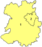
Sub-divisions
The area covered by the unitary authority is sub-divided into 63 electoral divisions, which are essentially wards. Shropshire Council has established three area committee
Area committee
Many large local government councils in the United Kingdom have a system of area committees, with responsibility for services in a particular part of the area covered by the council....
s, which deal with more local matters such as licensing and planning
Town and country planning in the United Kingdom
Town and Country Planning is the land use planning system governments use to balance economic development and environmental quality. Each country of the United Kingdom has its own planning system that is responsible for town and country planning devolved to the Northern Ireland Assembly, the...
. The area committees cover a geographical area based on the former (pre-2009 reforms) districts
Non-metropolitan district
Non-metropolitan districts, or colloquially shire districts, are a type of local government district in England. As created, they are sub-divisions of non-metropolitan counties in a so-called "two-tier" arrangement...
of Shropshire and which consist of electoral divisions with a combined representation of 24 or 25 councillors. The councillors who represent an area's electoral divisions then form the area committee for that area.
| Area committee | Former districts | Location(s) of headquarters | Land area (km²) | Population (2007 est.) | Number of councillors | Parliamentary constituencies |
|---|---|---|---|---|---|---|
| North | North Shropshire North Shropshire North Shropshire was a local government district in Shropshire, England. The district council was based at Edinburgh House, in Wem. Other settlements included the towns of Ellesmere, Market Drayton, Wem and Whitchurch, as well as the large villages of Shawbury and Baschurch... and Oswestry Oswestry (borough) Oswestry was a small local government district with borough status in Shropshire, England. It was the smallest of the five districts of Shropshire in terms of both population and land area.... |
Oswestry Oswestry Oswestry is a town and civil parish in Shropshire, England, close to the Welsh border. It is at the junction of the A5, A483, and A495 roads.... and Wem Wem Wem is a small market town in Shropshire, England. It is the administrative centre for the northern area committee of Shropshire Council, which has its headquarters at Edinburgh House in the centre of Wem. Wem railway station is on the Shrewsbury to Crewe railway line... |
935.25 | 100400 | 25 | North Shropshire North Shropshire (UK Parliament constituency) North Shropshire is a constituency represented in the House of Commons of the Parliament of the United Kingdom. From its first creation in 1832 to the abolition of the first creation in 1885 it elected two Knights of the Shire... |
| Central | Shrewsbury and Atcham Shrewsbury and Atcham Shrewsbury and Atcham was, between 1974 and 2009, a local government district with borough status in Shropshire, England.Shrewsbury was the only town in the borough; Atcham, although itself only a village, was included in the name as a reflection of the incorporation into the borough of the former... |
Shrewsbury Shrewsbury Shrewsbury is the county town of Shropshire, in the West Midlands region of England. Lying on the River Severn, it is a civil parish home to some 70,000 inhabitants, and is the primary settlement and headquarters of Shropshire Council... |
601.63 | 96200 | 24 | Shrewsbury and Atcham Shrewsbury and Atcham (UK Parliament constituency) Shrewsbury and Atcham is a parliamentary constituency represented in the House of Commons of the Parliament of the United Kingdom. It elects one Member of Parliament by the first past the post system of election.... |
| South | Bridgnorth Bridgnorth (district) Bridgnorth District was, between 1974 and 2009, a local government district in Shropshire, England. Its main town was Bridgnorth and other towns in its area were Much Wenlock, Shifnal and Broseley. The villages of Albrighton and Sheriffhales as well as RAF Cosford were also in the district.The... and South Shropshire South Shropshire South Shropshire was, between 1974 and 2009, a local government district in south west Shropshire, England.South Shropshire was the most rural district of one of the UK's most rural counties, the population of the district was 40,410 in 2001 spread out over 1,027 km² of forest, mountains,... |
Bridgnorth Bridgnorth Bridgnorth is a town in Shropshire, England, along the Severn Valley. It is split into Low Town and High Town, named on account of their elevations relative to the River Severn, which separates the upper town on the right bank from the lower on the left... and Ludlow Ludlow Ludlow is a market town in Shropshire, England close to the Welsh border and in the Welsh Marches. It lies within a bend of the River Teme, on its eastern bank, forming an area of and centred on a small hill. Atop this hill is the site of Ludlow Castle and the market place... |
1660.43 | 94300 | 25 | Ludlow Ludlow (UK Parliament constituency) Ludlow is a county constituency represented in the House of Commons of the Parliament of the United Kingdom. It elects one Member of Parliament by the first past the post system of election.... and The Wrekin The Wrekin (UK Parliament constituency) The Wrekin is a county constituency represented in the House of Commons of the Parliament of the United Kingdom since 1918. It elects one Member of Parliament by the first past the post system of election... (part) |
Committee meetings in the North and South areas will rotate between the two headquarters; the four headquarters of these areas were the headquarters of the former district councils in these two areas. The Central area has just one meeting location, The Shirehall, though some staff will be at The Guildhall, which was the headquarters of the former borough council.
This is similar to the arrangements at the neighbouring Powys County Council
Powys County Council
Powys County Council is the governing body for Powys, one of the administrative areas of Wales. It has three area committees — one for each of Brecknockshire, Radnorshire and Montgomeryshire to which the council delegates its functions. The council offices are located in Llandrindod...
, where the area covered is sub-divided into three areas, which were the previous (pre-merger) administrative divisions. The areas also correspond to the Westminster Parliament
Parliament of the United Kingdom
The Parliament of the United Kingdom of Great Britain and Northern Ireland is the supreme legislative body in the United Kingdom, British Crown dependencies and British overseas territories, located in London...
constituencies of Shropshire, with the North and Central areas being exactly coextensive with constituencies.
The county is entirely parished
Civil parish
In England, a civil parish is a territorial designation and, where they are found, the lowest tier of local government below districts and counties...
, with the formerly unparished area
Unparished area
In England, an unparished area is an area that is not covered by a civil parish. Most urbanised districts of England are either entirely or partly unparished. Many towns and some cities in otherwise rural districts are also unparished areas and therefore no longer have a town council or city...
of Shrewsbury having been parished in 2008, with a single parish covering the town. A number of "local joint committees" exist, which consist of councillors from both Shropshire Council and the parish council(s) in a particular locality.
The council
The council, which were elected in 2009, consist of 74 councillors from 53 single-member electoral divisions, nine 2-member divisions and one 3-member electoral division. In most instances the electoral division boundaries follow parishCivil parish
In England, a civil parish is a territorial designation and, where they are found, the lowest tier of local government below districts and counties...
boundary lines, with the main exceptions being in the larger towns, where the parish contains more than one electoral division. Shrewsbury for example, which was parished in 2008 as part of the change in local governance, contains 16 electoral divisions, one of which is the sole 3-member division that also encompasses the parish of Bayston Hill
Bayston Hill
Bayston Hill is a large village and civil parish in central Shropshire, England. It is south of the county town Shrewsbury and located on the main A49 road, the Shrewsbury to Hereford road....
.
Main positions
The council has three major positions to which councillors may be appointed:- Chairman - the ceremonial head of the council
- Speaker - who chairChair (official)The chairman is the highest officer of an organized group such as a board, committee, or deliberative assembly. The person holding the office is typically elected or appointed by the members of the group. The chairman presides over meetings of the assembled group and conducts its business in an...
s full council meetings - Leader - the leader of the controlling political group
The Leader and 9 additional portfolio holders form the Cabinet. This is effectively the executive branch of the authority.
Administration
The permanent head of the administrationCivil service
The term civil service has two distinct meanings:* A branch of governmental service in which individuals are employed on the basis of professional merit as proven by competitive examinations....
of the council is the Chief Executive. The employees of the council are structured within 2 departments; People and Places each of which is headed by a permanent director. Kym Ryeley is the current Chief Executive.
See also
- 2009 structural changes to local government in England2009 structural changes to local government in EnglandStructural changes to local government in England were effected on 1 April 2009, whereby a number of new unitary authorities were created in parts of the country which previously operated a 'two-tier' system of counties and districts...
- Shropshire local electionsShropshire local electionsShropshire Council is elected every four years. The council is the top-tier of local authorities in the non-metropolitan county of Shropshire, England.-Political control:...
- Shropshire Council election, 2009Shropshire Council election, 2009The first elections to Shropshire Council took place on 4 June 2009, having been delayed from 7 May in order to coincide with elections to the European Parliament.74 councillors were elected from 63 electoral divisions...
- Shropshire Council election, 2009
- Shrewsbury Town Council
- Telford and WrekinTelford and WrekinTelford and Wrekin is a unitary district with borough status in the West Midlands region of England. For Eurostat purposes it is a NUTS 3 region and is one of four counties or unitary districts that comprise the "Shropshire and Staffordshire" NUTS 2 region. The district was created in 1974 as The...
External links
- Shropshire Council - Official website
- Electoral Commission - Shropshire
- http://www.shropshire.gov.uk/community.nsf - Shropshire Community Directory