

Titterstone Clee Hill
Encyclopedia
Titterstone Clee Hill, sometimes referred to as Clee Hill or Titterstone Clee, is a hill
in the rural English
county of Shropshire
, rising at the summit to 533 m above sea level.
It is in the Clee Hills
, in the Shropshire Hills Area of Outstanding Natural Beauty
. The nearest town to the hill is Ludlow
.
(540 m) and Stiperstones
(536 m). Much of the higher part of the hill is common land
, used for the grazing of sheep, air traffic control
services and working or disused quarries
. The summit of Titterstone Clee is bleak, treeless and shaped by decades of quarrying. Many of the structures still remain, and lend to the ghostly atmosphere of the hill top, especially during the prolonged winter fogs that descend over the hills.
Recent scientific investigation has led to some individuals claiming that Titterstone Clee was once an active volcano. However, there has been no conclusive evidence to confirm these claims.
The weather on Titterstone Clee Hill can be particularly hazardous, with locally infamous fog
and drizzle being commonplace. Snow
can also cause problems in winter, as well as gales.
Most of the summit of the hill is effectively man-made, the result of years of quarrying dhustone (dolerite) to be used in road-building. Also, many derelict quarry buildings are scattered over the hill, now used only by sheep sheltering from the worst of weather. Combined, these give the summit of the hill an eerie, other worldly feel.
The A4117
between Cleobury Mortimer
and Ludlow
runs along the southern slope of Titterstone Clee, and rises to 381 metres above sea level at its highest point on Clee Hill Common. Because of this, the road is often affected by snow
in winter.
The small village of Cleehill
lies on this road as it crosses the hill, and at 395 metres above sea level, it is home to the highest pub in Shropshire
, called "The Kremlin".
From the hill it is possible on a clear day to see west to Snowdonia
, north east to the Peak District
, east to the Black Country
, south east to the Cotswolds
, south to the Malvern Hills, and south west to the Black Mountains
and Brecon Beacons
. The hill is said to provide one of the best views in England
on a clear day.
or dolerite. It is because of this that the hill is littered with many abandoned quarries and mine shafts, one of which has now flooded to form a lake. The largest quarries have sheer drops of up to around thirty meters (one hundred feet).
 Before the Second World War, the area would be described as industrial, because of the presence of wide-scale quarrying and associated activity. Men came from places such as Bridgnorth
and Ludlow
to work in the quarries, and the village of Dhustone on Titterstone Clee was built especially for the quarry workers. Crumbling remains of quarry buildings now litter the hill, reminders of a bygone industry that once employed more than 2,000 people here. An old railway incline is still visible on the hill, and a large concrete structure, under which the wagons were filled with stone, still remains next to the modern day car park. Railway infrastructure remained until the late 1950s. In the past the quarries have also been worked (on a much smaller scale) for coal
and limestone
.
Early in the 20th century, a second quarry opened on Titterstone Clee Hill and an aerial ropeway was built to carry stone off the hill to the railway at Detton Ford. The footings for the tall pylons which supported the wires still remain near the summit, parallel to the modern day track to the radar domes.
Titterstone Clee is still quarried, but on a much smaller scale than in its heyday, on the lower slopes behind Cleehill village. Quarrying resumed in the late 1980s 50 years after the summit Dhustone quarry closed, and some old workings have been restored. The main buildings of the quarry are just visible from the A4117 road.
Several radar
domes and towers operate on the summit
of the hill. The radar arrays are part of the National Air Traffic Services
(NATS) radar network, and cover one of 30 overlapping regions of UK airspace. The ones on the Clee Hills monitor all aircraft within a 100-mile radius. The domes and masts are well-known local landmarks, with one in particular often being nicknamed "the golf ball" because of it looking like a giant teed-up golf ball. They can be seen for many miles, even from some parts of The Black Country.
A 20th Century triangulation pillar marks the summit, whilst just to the left of it are the remains of a Bronze Age
cairn
, dating back up to 4,000 years and indicating that the summit was a likely ceremonial site. Although badly damaged by quarrying, Titterstone Clee's Iron Age
hill fort
has fared better than those on Brown Clee
. It is of note that the walls of the fort are made up of stone blocks, instead of earth banks. Also near the summit is the "giant's chair" - a pile of boulders left behind
in the ice age.
Titterstone Clee is popular with walkers, but much less so than neighbouring hills such as the Long Mynd
. Walkers can access the summit by taking the A4117 from just past Bewdley
and Ludlow
. About three quarters of a mile to the Ludlow side of Cleehill
village, turn right up the single-track road signposted "Dhustone" and "Titterstone Clee summit". Drive to the top of the track and park on the old railway yard near the old quarry buildings. To walk to the summit follow the track around the radar installations.
."
Clee Hill is the only hill noted on the Mappa Mundi, a13th? Century map of the world displayed at Heteford Cathederal. The monk who drew the map must have been local to the hill, which is 30 miles from Hereford.
Hill
A hill is a landform that extends above the surrounding terrain. Hills often have a distinct summit, although in areas with scarp/dip topography a hill may refer to a particular section of flat terrain without a massive summit A hill is a landform that extends above the surrounding terrain. Hills...
in the rural English
England
England is a country that is part of the United Kingdom. It shares land borders with Scotland to the north and Wales to the west; the Irish Sea is to the north west, the Celtic Sea to the south west, with the North Sea to the east and the English Channel to the south separating it from continental...
county of Shropshire
Shropshire
Shropshire is a county in the West Midlands region of England. For Eurostat purposes, the county is a NUTS 3 region and is one of four counties or unitary districts that comprise the "Shropshire and Staffordshire" NUTS 2 region. It borders Wales to the west...
, rising at the summit to 533 m above sea level.
It is in the Clee Hills
Clee Hills
The Clee Hills are a range of hills in Shropshire, England near Ludlow, consisting of Brown Clee Hill , the highest peak in Shropshire, and Titterstone Clee Hill...
, in the Shropshire Hills Area of Outstanding Natural Beauty
Area of Outstanding Natural Beauty
An Area of Outstanding Natural Beauty is an area of countryside considered to have significant landscape value in England, Wales or Northern Ireland, that has been specially designated by the Countryside Agency on behalf of the United Kingdom government; the Countryside Council for Wales on...
. The nearest town to the hill is Ludlow
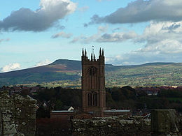
Ludlow
Ludlow is a market town in Shropshire, England close to the Welsh border and in the Welsh Marches. It lies within a bend of the River Teme, on its eastern bank, forming an area of and centred on a small hill. Atop this hill is the site of Ludlow Castle and the market place...
.
Geography
Titterstone Clee is the third-highest hill in Shropshire, beaten only by the nearby Brown Clee HillBrown Clee Hill
Brown Clee Hill is the highest hill in the rural English county of Shropshire, at 540 metres above sea level. It is one of the Clee Hills, and is in the Shropshire Hills Area of Outstanding Natural Beauty.-Geography:...
(540 m) and Stiperstones
Stiperstones
The Stiperstones is a very distinctive hill in the county of Shropshire, England. It is a quartzite ridge formed some 480 Million years ago. During the last Ice Age the summit stood out above the glaciers and was subject to constant freezing and thawing which shattered the quartzite into a mass of...
(536 m). Much of the higher part of the hill is common land
Common land
Common land is land owned collectively or by one person, but over which other people have certain traditional rights, such as to allow their livestock to graze upon it, to collect firewood, or to cut turf for fuel...
, used for the grazing of sheep, air traffic control
Air traffic control
Air traffic control is a service provided by ground-based controllers who direct aircraft on the ground and in the air. The primary purpose of ATC systems worldwide is to separate aircraft to prevent collisions, to organize and expedite the flow of traffic, and to provide information and other...
services and working or disused quarries
Quarry
A quarry is a type of open-pit mine from which rock or minerals are extracted. Quarries are generally used for extracting building materials, such as dimension stone, construction aggregate, riprap, sand, and gravel. They are often collocated with concrete and asphalt plants due to the requirement...
. The summit of Titterstone Clee is bleak, treeless and shaped by decades of quarrying. Many of the structures still remain, and lend to the ghostly atmosphere of the hill top, especially during the prolonged winter fogs that descend over the hills.
Recent scientific investigation has led to some individuals claiming that Titterstone Clee was once an active volcano. However, there has been no conclusive evidence to confirm these claims.
The weather on Titterstone Clee Hill can be particularly hazardous, with locally infamous fog
Fog
Fog is a collection of water droplets or ice crystals suspended in the air at or near the Earth's surface. While fog is a type of stratus cloud, the term "fog" is typically distinguished from the more generic term "cloud" in that fog is low-lying, and the moisture in the fog is often generated...
and drizzle being commonplace. Snow
Snow
Snow is a form of precipitation within the Earth's atmosphere in the form of crystalline water ice, consisting of a multitude of snowflakes that fall from clouds. Since snow is composed of small ice particles, it is a granular material. It has an open and therefore soft structure, unless packed by...
can also cause problems in winter, as well as gales.
Most of the summit of the hill is effectively man-made, the result of years of quarrying dhustone (dolerite) to be used in road-building. Also, many derelict quarry buildings are scattered over the hill, now used only by sheep sheltering from the worst of weather. Combined, these give the summit of the hill an eerie, other worldly feel.
The A4117
A4117 road
The A4117 is a major road in England. It branches from the A456 west of Bewdley, and runs westward to Ludlow via Cleobury Mortimer and Cleehill. The pass over Titterstone Clee Hill reaches an altitude of 381 metres, making the A4117 Shropshire's highest A-road...
between Cleobury Mortimer
Cleobury Mortimer
Cleobury Mortimer is a small rural market town in Shropshire, England. The town's parish has a population of 1,962 according to the 2001 census. Although sometimes regarded as a village, it is in fact the second smallest town in Shropshire , having been granted a town charter in 1253.Several...
and Ludlow
Ludlow
Ludlow is a market town in Shropshire, England close to the Welsh border and in the Welsh Marches. It lies within a bend of the River Teme, on its eastern bank, forming an area of and centred on a small hill. Atop this hill is the site of Ludlow Castle and the market place...
runs along the southern slope of Titterstone Clee, and rises to 381 metres above sea level at its highest point on Clee Hill Common. Because of this, the road is often affected by snow
Snow
Snow is a form of precipitation within the Earth's atmosphere in the form of crystalline water ice, consisting of a multitude of snowflakes that fall from clouds. Since snow is composed of small ice particles, it is a granular material. It has an open and therefore soft structure, unless packed by...
in winter.
The small village of Cleehill
Cleehill
Cleehill is a village in Shropshire, England. It is sometimes written as Clee Hill Village to avoid confusion....
lies on this road as it crosses the hill, and at 395 metres above sea level, it is home to the highest pub in Shropshire
Shropshire
Shropshire is a county in the West Midlands region of England. For Eurostat purposes, the county is a NUTS 3 region and is one of four counties or unitary districts that comprise the "Shropshire and Staffordshire" NUTS 2 region. It borders Wales to the west...
, called "The Kremlin".
From the hill it is possible on a clear day to see west to Snowdonia
Snowdonia
Snowdonia is a region in north Wales and a national park of in area. It was the first to be designated of the three National Parks in Wales, in 1951.-Name and extent:...
, north east to the Peak District
Peak District
The Peak District is an upland area in central and northern England, lying mainly in northern Derbyshire, but also covering parts of Cheshire, Greater Manchester, Staffordshire, and South and West Yorkshire....
, east to the Black Country
Black Country
The Black Country is a loosely defined area of the English West Midlands conurbation, to the north and west of Birmingham, and to the south and east of Wolverhampton. During the industrial revolution in the 19th century this area had become one of the most intensely industrialised in the nation...
, south east to the Cotswolds
Cotswolds
The Cotswolds are a range of hills in west-central England, sometimes called the Heart of England, an area across and long. The area has been designated as the Cotswold Area of Outstanding Natural Beauty...
, south to the Malvern Hills, and south west to the Black Mountains
Black Mountains, Wales
The Black Mountains are a group of hills spread across parts of Powys and Monmouthshire in southeast Wales, and extending across the national border into Herefordshire, England. They are the easternmost of the four ranges of hills that comprise the Brecon Beacons National Park, and are frequently...
and Brecon Beacons
Brecon Beacons
The Brecon Beacons is a mountain range in South Wales. In a narrow sense, the name refers to the range of popular peaks south of Brecon, including South Wales' highest mountain, Pen y Fan, and which together form the central section of the Brecon Beacons National Park...
. The hill is said to provide one of the best views in England
England
England is a country that is part of the United Kingdom. It shares land borders with Scotland to the north and Wales to the west; the Irish Sea is to the north west, the Celtic Sea to the south west, with the North Sea to the east and the English Channel to the south separating it from continental...
on a clear day.
History, quarrying and land usage
Over the years Titterstone Clee has been subject to much quarrying for dhustoneDiabase
Diabase or dolerite is a mafic, holocrystalline, subvolcanic rock equivalent to volcanic basalt or plutonic gabbro. In North American usage, the term diabase refers to the fresh rock, whilst elsewhere the term dolerite is used for the fresh rock and diabase refers to altered material...
or dolerite. It is because of this that the hill is littered with many abandoned quarries and mine shafts, one of which has now flooded to form a lake. The largest quarries have sheer drops of up to around thirty meters (one hundred feet).
Bridgnorth
Bridgnorth is a town in Shropshire, England, along the Severn Valley. It is split into Low Town and High Town, named on account of their elevations relative to the River Severn, which separates the upper town on the right bank from the lower on the left...
and Ludlow
Ludlow
Ludlow is a market town in Shropshire, England close to the Welsh border and in the Welsh Marches. It lies within a bend of the River Teme, on its eastern bank, forming an area of and centred on a small hill. Atop this hill is the site of Ludlow Castle and the market place...
to work in the quarries, and the village of Dhustone on Titterstone Clee was built especially for the quarry workers. Crumbling remains of quarry buildings now litter the hill, reminders of a bygone industry that once employed more than 2,000 people here. An old railway incline is still visible on the hill, and a large concrete structure, under which the wagons were filled with stone, still remains next to the modern day car park. Railway infrastructure remained until the late 1950s. In the past the quarries have also been worked (on a much smaller scale) for coal
Coal
Coal is a combustible black or brownish-black sedimentary rock usually occurring in rock strata in layers or veins called coal beds or coal seams. The harder forms, such as anthracite coal, can be regarded as metamorphic rock because of later exposure to elevated temperature and pressure...
and limestone
Limestone
Limestone is a sedimentary rock composed largely of the minerals calcite and aragonite, which are different crystal forms of calcium carbonate . Many limestones are composed from skeletal fragments of marine organisms such as coral or foraminifera....
.
Early in the 20th century, a second quarry opened on Titterstone Clee Hill and an aerial ropeway was built to carry stone off the hill to the railway at Detton Ford. The footings for the tall pylons which supported the wires still remain near the summit, parallel to the modern day track to the radar domes.
Titterstone Clee is still quarried, but on a much smaller scale than in its heyday, on the lower slopes behind Cleehill village. Quarrying resumed in the late 1980s 50 years after the summit Dhustone quarry closed, and some old workings have been restored. The main buildings of the quarry are just visible from the A4117 road.
Several radar
Radar
Radar is an object-detection system which uses radio waves to determine the range, altitude, direction, or speed of objects. It can be used to detect aircraft, ships, spacecraft, guided missiles, motor vehicles, weather formations, and terrain. The radar dish or antenna transmits pulses of radio...
domes and towers operate on the summit
Summit (topography)
In topography, a summit is a point on a surface that is higher in elevation than all points immediately adjacent to it. Mathematically, a summit is a local maximum in elevation...
of the hill. The radar arrays are part of the National Air Traffic Services
National Air Traffic Services
NATS Ltd. is the main air navigation service provider in the United Kingdom. It provides en-route air traffic control services to flights within the UK Flight Information Regions and the Shanwick Oceanic Control Area, and provides air traffic control services to fifteen UK airports and Gibraltar...
(NATS) radar network, and cover one of 30 overlapping regions of UK airspace. The ones on the Clee Hills monitor all aircraft within a 100-mile radius. The domes and masts are well-known local landmarks, with one in particular often being nicknamed "the golf ball" because of it looking like a giant teed-up golf ball. They can be seen for many miles, even from some parts of The Black Country.
A 20th Century triangulation pillar marks the summit, whilst just to the left of it are the remains of a Bronze Age
Bronze Age
The Bronze Age is a period characterized by the use of copper and its alloy bronze as the chief hard materials in the manufacture of some implements and weapons. Chronologically, it stands between the Stone Age and Iron Age...
cairn
Cairn
Cairn is a term used mainly in the English-speaking world for a man-made pile of stones. It comes from the or . Cairns are found all over the world in uplands, on moorland, on mountaintops, near waterways and on sea cliffs, and also in barren desert and tundra areas...
, dating back up to 4,000 years and indicating that the summit was a likely ceremonial site. Although badly damaged by quarrying, Titterstone Clee's Iron Age
Iron Age
The Iron Age is the archaeological period generally occurring after the Bronze Age, marked by the prevalent use of iron. The early period of the age is characterized by the widespread use of iron or steel. The adoption of such material coincided with other changes in society, including differing...
hill fort
Hill fort
A hill fort is a type of earthworks used as a fortified refuge or defended settlement, located to exploit a rise in elevation for defensive advantage. They are typically European and of the Bronze and Iron Ages. Some were used in the post-Roman period...
has fared better than those on Brown Clee
Brown Clee Hill
Brown Clee Hill is the highest hill in the rural English county of Shropshire, at 540 metres above sea level. It is one of the Clee Hills, and is in the Shropshire Hills Area of Outstanding Natural Beauty.-Geography:...
. It is of note that the walls of the fort are made up of stone blocks, instead of earth banks. Also near the summit is the "giant's chair" - a pile of boulders left behind
Glacial erratic
A glacial erratic is a piece of rock that differs from the size and type of rock native to the area in which it rests. "Erratics" take their name from the Latin word errare, and are carried by glacial ice, often over distances of hundreds of kilometres...
in the ice age.
Titterstone Clee is popular with walkers, but much less so than neighbouring hills such as the Long Mynd
Long Mynd
The Long Mynd in Shropshire, England, is a part of the Shropshire Hills Area of Outstanding Natural Beauty. It is south of the county town Shrewsbury, and has an area of over 22 square kilometres , most of which takes the form of a heathland plateau. Most of the land on the Long Mynd is owned by...
. Walkers can access the summit by taking the A4117 from just past Bewdley
Bewdley
Bewdley is a town and civil parish in the Wyre Forest District of Worcestershire, England, along the Severn Valley a few miles to the west of Kidderminster...
and Ludlow
Ludlow
Ludlow is a market town in Shropshire, England close to the Welsh border and in the Welsh Marches. It lies within a bend of the River Teme, on its eastern bank, forming an area of and centred on a small hill. Atop this hill is the site of Ludlow Castle and the market place...
. About three quarters of a mile to the Ludlow side of Cleehill
Cleehill
Cleehill is a village in Shropshire, England. It is sometimes written as Clee Hill Village to avoid confusion....
village, turn right up the single-track road signposted "Dhustone" and "Titterstone Clee summit". Drive to the top of the track and park on the old railway yard near the old quarry buildings. To walk to the summit follow the track around the radar installations.
In fiction
Titterstone Clee plays a central role in the Ellis Peters' novel "The Virgin in the IceThe Virgin in the Ice
The Virgin in the Ice is a medieval mystery novel by Ellis Peters, first published in 1982. It was adapted for television in 1995 by Central for ITV. It is the sixth novel in the Brother Cadfael series.-Plot summary:...
."
External links
- Shropshire Geology - Titterstone Clee
- Computer generated summit panorama from Titterstone Clee
- BBC Shropshire photo gallery
- Simon Denison - Quarry land
Clee Hill is the only hill noted on the Mappa Mundi, a13th? Century map of the world displayed at Heteford Cathederal. The monk who drew the map must have been local to the hill, which is 30 miles from Hereford.