
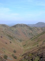
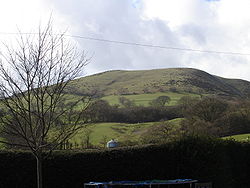
Long Mynd
Encyclopedia

Shropshire
Shropshire is a county in the West Midlands region of England. For Eurostat purposes, the county is a NUTS 3 region and is one of four counties or unitary districts that comprise the "Shropshire and Staffordshire" NUTS 2 region. It borders Wales to the west...
, England, is a part of the Shropshire Hills Area of Outstanding Natural Beauty
Area of Outstanding Natural Beauty
An Area of Outstanding Natural Beauty is an area of countryside considered to have significant landscape value in England, Wales or Northern Ireland, that has been specially designated by the Countryside Agency on behalf of the United Kingdom government; the Countryside Council for Wales on...
. It is 10 miles (16.1 km) south of the county town Shrewsbury
Shrewsbury
Shrewsbury is the county town of Shropshire, in the West Midlands region of England. Lying on the River Severn, it is a civil parish home to some 70,000 inhabitants, and is the primary settlement and headquarters of Shropshire Council...
, and has an area of over 22 square kilometres (8.5 sq mi), most of which takes the form of a heathland plateau. Most of the land on the Long Mynd is owned by the National Trust
National Trust for Places of Historic Interest or Natural Beauty
The National Trust for Places of Historic Interest or Natural Beauty, usually known as the National Trust, is a conservation organisation in England, Wales and Northern Ireland...
.
The name Long Mynd means "Long Mountain". In Welsh
Welsh language
Welsh is a member of the Brythonic branch of the Celtic languages spoken natively in Wales, by some along the Welsh border in England, and in Y Wladfa...
it is called Mynydd Hir ˈmənɪð ˈhiːr. The Long Mynd stands between the Stiperstones
Stiperstones
The Stiperstones is a very distinctive hill in the county of Shropshire, England. It is a quartzite ridge formed some 480 Million years ago. During the last Ice Age the summit stood out above the glaciers and was subject to constant freezing and thawing which shattered the quartzite into a mass of...
range to the west and the Stretton Hills and Wenlock Edge
Wenlock Edge
Wenlock Edge is a limestone escarpment near Much Wenlock, Shropshire, England. It is long and runs from South West to North East between Craven Arms and Much Wenlock. It is roughly 330 metres high...
to the east. The eastern edge of the Mynd has many steep valleys, though its western slope rises in a steep escarpment above the wide valley of the River East Onny. North to south, it is approximately 7 miles (11.3 km) long by a maximum of 3 miles (4.8 km) wide. The principal settlements surrounding the Long Mynd are the Strettons (Church Stretton
Church Stretton
Church Stretton is a small town and civil parish in Shropshire, England. The population of the town was recorded as 2,789 in 2001, whilst the population of the wider parish was recorded as 4,186...
, Little Stretton
Little Stretton, Shropshire
Little Stretton is a village in Shropshire, England.It lies on the B5477 to the south of the town of Church Stretton ; similarly, the small village of All Stretton lies to the north of Church Stretton on the same road...
and All Stretton
All Stretton
All Stretton is a village and civil parish in Shropshire, England.-Geography:All Stretton lies about a mile to the north of the market town of Church Stretton, on the old Shrewsbury Road - the county town is 12 miles to the north. Similarly, the small village of Little Stretton lies to the south...
), Pulverbatch, Smethcott
Smethcott
Smethcott is a civil parish and dispersed hamlet near the village of Picklescott, in Shropshire, England.The name Smethcott has an Old English origin, and means "cottage of the smiths"...
, Woolstaston
Woolstaston
Woolstaston is a small village and civil parish in Shropshire, England.It is located in the northern foothills of the Long Mynd and is situated near Leebotwood, Smethcott and Picklescott. The parish is geographically very small, covering only the village, the lanes leading to it and a small part of...
, Asterton
Asterton
Asterton is a village in Shropshire in the civil parish of Myndtown. The name means "eastern home farm", from Old English east "east" and ham-tun "home farm". The name was recorded as Esthemtone in 986. Asterton is notable for being at the foot of the very steep, precipitous lane which climbs the...
, Myndtown
Myndtown
Myndtown is a small village and civil parish in rural Shropshire, around 5 miles to the north-east of Bishop's Castle....
, Wentnor and Ratlinghope
Ratlinghope
Ratlinghope is a village and civil parish in Shropshire, England. It is situated four miles west from Church Stretton and twelve miles south from Shrewsbury.Historically it is located in the hundred of Purslow...
. The highest point on the Long Mynd is Pole Bank at a height of 516 m (1,692.9 ft). Pole Bank and nearby Caer Caradoc, at 459 m (1,505.9 ft), are both Marilyns
Marilyn (hill)
A Marilyn is a mountain or hill in the United Kingdom, Republic of Ireland or Isle of Man with a relative height of at least 150 metres , regardless of absolute height or other merit...
.
Geology
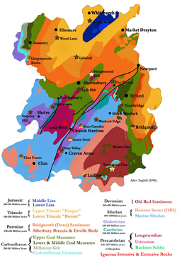
Geology of Shropshire
Shropshire's Geology is very diverse and most rock types found in the British Isles can be found in the county too. There is also a large amount of mineral wealth, including lead, coal and iron in the county, which perhaps helped the area develop the first industry of the industrial revolution, in...
and Longmyndian Supergroup
Longmyndian Supergroup
The Longmyndian Supergroup is a c.6000m thick sequence of rocks that outcrop between the Pontesford-Linley Fault System and the Church Stretton Fault System in the Welsh Borderland. The supergroup consists of two major geological groups, the Stretton Group and the overlying Wentnor Group. The rocks...
The geology
Geology
Geology is the science comprising the study of solid Earth, the rocks of which it is composed, and the processes by which it evolves. Geology gives insight into the history of the Earth, as it provides the primary evidence for plate tectonics, the evolutionary history of life, and past climates...
dates back to Precambrian
Precambrian
The Precambrian is the name which describes the large span of time in Earth's history before the current Phanerozoic Eon, and is a Supereon divided into several eons of the geologic time scale...
, and during the time would have been 60° south of the equator
Equator
An equator is the intersection of a sphere's surface with the plane perpendicular to the sphere's axis of rotation and containing the sphere's center of mass....
, the same latitude as the Falkland Islands
Falkland Islands
The Falkland Islands are an archipelago in the South Atlantic Ocean, located about from the coast of mainland South America. The archipelago consists of East Falkland, West Falkland and 776 lesser islands. The capital, Stanley, is on East Falkland...
. Shropshire would have been at the very edge of a large continent
Continent
A continent is one of several very large landmasses on Earth. They are generally identified by convention rather than any strict criteria, with seven regions commonly regarded as continents—they are : Asia, Africa, North America, South America, Antarctica, Europe, and Australia.Plate tectonics is...
near the sea, which was being buckled by tectonic activity, causing volcanoes to form. The area had broad rivers; evidence of mudflats has been found. The rivers would have flowed out to sea, creating large estuaries; over time, the mudflats would have built up, and volcanic eruptions deposited ash in layers between the sand and mud. The primary rock of the Long Mynd is sandstone, usually coloured purple or grey. The volcanoes created the nearby Stretton Hills and the Wrekin, and eruptions would have been frequent. There are layers in the rocks of the Long Mynd that have preserved raindrop marks recording a passing rain shower. The raindrop marks were created when rain fell onto a layer of firm dry mud, and were then covered by another layer of mud, which filled them in and preserved them for 565 million years. Examples of these fossil
Fossil
Fossils are the preserved remains or traces of animals , plants, and other organisms from the remote past...
ised rain prints can be viewed today in the National Trust
National Trust for Places of Historic Interest or Natural Beauty
The National Trust for Places of Historic Interest or Natural Beauty, usually known as the National Trust, is a conservation organisation in England, Wales and Northern Ireland...
Tearoom Exhibition, in Carding Mill Valley. The layers of rock built up over the millennia to create an approximately 7000 m (22,965.9 ft) thick layer composed of sand, mud, silt, and ash.
Towards the end of the Precambrian period, the volcanoes ceased their eruptions, and the rivers had dried up. Instead the forces that created the volcanoes caused the new rocks to lift and fold, creating mountains and valleys in the area. Much of the rock was melted during this period, underneath the Earth's crust
Crust (geology)
In geology, the crust is the outermost solid shell of a rocky planet or natural satellite, which is chemically distinct from the underlying mantle...
, causing the mountains to continually change towards the latter part of the Precambrian. The Church Stretton Fault line was created during this period, and is still active today. The hill Caer Caradoc adjacent to the Long Mynd and from the same time is more volcanic in origin, and is thought to be the remnants of the great mountain chain.
During the Cambrian
Cambrian
The Cambrian is the first geological period of the Paleozoic Era, lasting from Mya ; it is succeeded by the Ordovician. Its subdivisions, and indeed its base, are somewhat in flux. The period was established by Adam Sedgwick, who named it after Cambria, the Latin name for Wales, where Britain's...
, Shropshire was flooded by the sea, after the Global Ice Age ended 545 million years ago. Thick layers of beach pebbles and white sand were built up against the sea cliffs that were once molten lava. During this time, the shallow sea played host to the huge explosion of new life which occurred during the Cambrian. Shropshire has some of the most historically important evidence in the explosion of life and in the naming and dividing of the Cambrian period. Trilobite
Trilobite
Trilobites are a well-known fossil group of extinct marine arthropods that form the class Trilobita. The first appearance of trilobites in the fossil record defines the base of the Atdabanian stage of the Early Cambrian period , and they flourished throughout the lower Paleozoic era before...
s that are found in the county are internationally important for deciding how the Cambrian is divided into smaller segments of time.
The Ordovician
Ordovician
The Ordovician is a geologic period and system, the second of six of the Paleozoic Era, and covers the time between 488.3±1.7 to 443.7±1.5 million years ago . It follows the Cambrian Period and is followed by the Silurian Period...
had Shropshire back to volcanic activity, and saw the county temporarily split in two, along the Pontesford - Linley fault line. Everything west of this line was ocean, while the east was dry land. The Iapetus Ocean
Iapetus Ocean
The Iapetus Ocean was an ocean that existed in the Neoproterozoic and Paleozoic eras of the geologic timescale . The Iapetus Ocean was situated in the southern hemisphere, between the paleocontinents of Laurentia, Baltica and Avalonia...
was closing,0 bringing the two halves of Britain towards each other, and volcanic eruptions created the Cumbrian Mountains, and Snowdonia
Snowdonia
Snowdonia is a region in north Wales and a national park of in area. It was the first to be designated of the three National Parks in Wales, in 1951.-Name and extent:...
. Shropshire also saw volcanic activity. To the west of the Pontesford - Linley fault, volcanic rocks have been found. The other side of the fault line was quieter. The land was slowly eroded, and the sea gradually flooded it, so that only the tops of hills could be seen, such as the ancient Caer Caradoc. Towards the end of the Ordovician, the sea levels dropped, due to another ice age.
The Silurian
Silurian
The Silurian is a geologic period and system that extends from the end of the Ordovician Period, about 443.7 ± 1.5 Mya , to the beginning of the Devonian Period, about 416.0 ± 2.8 Mya . As with other geologic periods, the rock beds that define the period's start and end are well identified, but the...
period, occurring 439 million years ago, has been well preserved nearby, in Wenlock Edge
Wenlock Edge
Wenlock Edge is a limestone escarpment near Much Wenlock, Shropshire, England. It is long and runs from South West to North East between Craven Arms and Much Wenlock. It is roughly 330 metres high...
. During this time, Shropshire would have been flooded again by shallow sea. Wenlock Edge would have formed during this time, and the fossils of ancient corals and shellfish
Shellfish
Shellfish is a culinary and fisheries term for exoskeleton-bearing aquatic invertebrates used as food, including various species of molluscs, crustaceans, and echinoderms. Although most kinds of shellfish are harvested from saltwater environments, some kinds are found only in freshwater...
can be found all along the Edge, preserved in limestone
Limestone
Limestone is a sedimentary rock composed largely of the minerals calcite and aragonite, which are different crystal forms of calcium carbonate . Many limestones are composed from skeletal fragments of marine organisms such as coral or foraminifera....
. Towards the end of the Silurian the Iapetus would have fully closed, and England and Scotland
Scotland
Scotland is a country that is part of the United Kingdom. Occupying the northern third of the island of Great Britain, it shares a border with England to the south and is bounded by the North Sea to the east, the Atlantic Ocean to the north and west, and the North Channel and Irish Sea to the...
were joined. The closing of this ocean was important to geology in Great Britain. It caused most of our hills and mountains to align along the fault, northeast to the southwest.
During the Devonian
Devonian
The Devonian is a geologic period and system of the Paleozoic Era spanning from the end of the Silurian Period, about 416.0 ± 2.8 Mya , to the beginning of the Carboniferous Period, about 359.2 ± 2.5 Mya...
, the newly formed Scottish Mountains had rivers flowing all over the land. Shropshire was no exception; these new rivers caused thick deposits in the area. Most of the rocks from this era are red sandstones, caused by iron in the rock. The area was known as the Old Red Sandstone Continent. These river sediments have traces of fossilised fish. Shropshire would have remained above water until the end of the Devonian, when the seas rose once again.
The Carboniferous
Carboniferous
The Carboniferous is a geologic period and system that extends from the end of the Devonian Period, about 359.2 ± 2.5 Mya , to the beginning of the Permian Period, about 299.0 ± 0.8 Mya . The name is derived from the Latin word for coal, carbo. Carboniferous means "coal-bearing"...
was a time of great change for the area. Shropshire would have been near the equator, and the Old Red Sandstone continent had been eroded away; in the early part of the era, the county was under a shallow sea. However, tectonic activity pushed Britain out of the sea. South of Shropshire this effect was felt greatly, though Shropshire was relatively quiet. Mountains to the north were being worn down by rivers, creating enormous deltas that were colonised by plant life. A tropical forest took hold all over Shropshire, with ancient tree ferns and horsetails. Shropshire eventually crossed the equator during this era, and became a part of Pangaea
Pangaea
Pangaea, Pangæa, or Pangea is hypothesized as a supercontinent that existed during the Paleozoic and Mesozoic eras about 250 million years ago, before the component continents were separated into their current configuration....
during the Permian
Permian
The PermianThe term "Permian" was introduced into geology in 1841 by Sir Sir R. I. Murchison, president of the Geological Society of London, who identified typical strata in extensive Russian explorations undertaken with Edouard de Verneuil; Murchison asserted in 1841 that he named his "Permian...
; the area would have been very similar to the Sahara Desert, and would have been in the vicinity, around 20° to 30° north of the equator.
The Triassic
Triassic
The Triassic is a geologic period and system that extends from about 250 to 200 Mya . As the first period of the Mesozoic Era, the Triassic follows the Permian and is followed by the Jurassic. Both the start and end of the Triassic are marked by major extinction events...
, Jurassic
Jurassic
The Jurassic is a geologic period and system that extends from about Mya to Mya, that is, from the end of the Triassic to the beginning of the Cretaceous. The Jurassic constitutes the middle period of the Mesozoic era, also known as the age of reptiles. The start of the period is marked by...
, Cretaceous
Cretaceous
The Cretaceous , derived from the Latin "creta" , usually abbreviated K for its German translation Kreide , is a geologic period and system from circa to million years ago. In the geologic timescale, the Cretaceous follows the Jurassic period and is followed by the Paleogene period of the...
and Tertiary
Tertiary
The Tertiary is a deprecated term for a geologic period 65 million to 2.6 million years ago. The Tertiary covered the time span between the superseded Secondary period and the Quaternary...
were very quiet in Shropshire, and very little evidence can be found from these periods. The last Ice Age
Ice age
An ice age or, more precisely, glacial age, is a generic geological period of long-term reduction in the temperature of the Earth's surface and atmosphere, resulting in the presence or expansion of continental ice sheets, polar ice sheets and alpine glaciers...
during the Quaternary
Quaternary
The Quaternary Period is the most recent of the three periods of the Cenozoic Era in the geologic time scale of the ICS. It follows the Neogene Period, spanning 2.588 ± 0.005 million years ago to the present...
has its effect on all of Shropshire, shaping the landscape as we see it today. The Long Mynd would have been under a thick Ice Sheet, several hundred metres thick. As the ice melted, it carved out the valleys and hills of the Long Mynd massif we see today. The small rivers, streams and brooks still very slowly carve out the valleys. The springs and bogs play a part in Church Stretton's economy, as the people bottle the mineral water that comes from the Long Mynd.
Today the steep and narrow valleys are covered in a thin layer of soil, with a low pH
PH
In chemistry, pH is a measure of the acidity or basicity of an aqueous solution. Pure water is said to be neutral, with a pH close to 7.0 at . Solutions with a pH less than 7 are said to be acidic and solutions with a pH greater than 7 are basic or alkaline...
, able to support only strong grasses, rushes
Juncus
Juncus is a genus in the plant family Juncaceae. It consists of some 200 to 300 or more species of grassy plants commonly called rushes...
, and heathers
Ericaceae
The Ericaceae, commonly known as the heath or heather family, is a group of mostly calcifuge flowering plants. The family is large, with roughly 4000 species spread across 126 genera, making it the 14th most speciose family of flowering plants...
. Beneath the soil the evidence of the ancient and chequered past can be seen, and the rocky outcrop
Outcrop
An outcrop is a visible exposure of bedrock or ancient superficial deposits on the surface of the Earth. -Features:Outcrops do not cover the majority of the Earth's land surface because in most places the bedrock or superficial deposits are covered by a mantle of soil and vegetation and cannot be...
s and scree
Scree
Scree, also called talus, is a term given to an accumulation of broken rock fragments at the base of crags, mountain cliffs, or valley shoulders. Landforms associated with these materials are sometimes called scree slopes or talus piles...
slopes are excellent places to view the different layers of ancient rock.
Since 2006, Cambridge University has monitored seismic activity in Long Mynd. The broadband seismometer
Seismometer
Seismometers are instruments that measure motions of the ground, including those of seismic waves generated by earthquakes, volcanic eruptions, and other seismic sources...
is connected to the internet, and real-time traces can be viewed online here.
Bronze Age
The Bronze AgeBronze Age
The Bronze Age is a period characterized by the use of copper and its alloy bronze as the chief hard materials in the manufacture of some implements and weapons. Chronologically, it stands between the Stone Age and Iron Age...
period is by far the most recorded period of time on the Long Mynd. There are dozens of tumuli on the moorland. Some are small, the remains of chamber tombs for example. Others are quite large, the sites on the Long Mynd, from the Bronze Age, include Dykes and Barrows.
Barristers Plain Cross-Ridge Dyke runs south-west to north-east, almost in a straight line for 170 m (557.7 ft). It runs across the narrowest area of a ridge
Ridge
A ridge is a geological feature consisting of a chain of mountains or hills that form a continuous elevated crest for some distance. Ridges are usually termed hills or mountains as well, depending on size. There are several main types of ridges:...
between Grindle Hill and Round Hill. The remains of the dyke is now covered in heather, and is approximately 5.5 m (18 ft), and is 0.5 m (1.6 ft). On its western side it is fronted by a 3 m (9.8 ft) wide ditch
Ditch
A ditch is usually defined as a small to moderate depression created to channel water.In Anglo-Saxon, the word dïc already existed and was pronounced 'deek' in northern England and 'deetch' in the south. The origins of the word lie in digging a trench and forming the upcast soil into a bank...
. At both ends of the Cross Ridge Dyke, it fades into the steep hillside. A gap in the dyke, 60 m (196.9 ft) from the south-east end, is thought to make room for a trackway along the ridge. Its purpose was to cut off Grindle Hill from the main plateau
Plateau
In geology and earth science, a plateau , also called a high plain or tableland, is an area of highland, usually consisting of relatively flat terrain. A highly eroded plateau is called a dissected plateau...
, and to create a barrier for access from the west.
Devils Mouth Cross-Ridge Dyke lies between Cardingmill Valley and Townbrook Valley. The dyke is 140 m (459.3 ft) long, but is cut though by the Burway Way and a small car park, 35 m (114.8 ft) of the dyke is now missing. Both ends of the dyke end on steep slopes! It was built with stone and earth, and is 6 m (19.7 ft) wide, and 1.5 m (4.9 ft) high, with shallow ditches either side. It is roughly 1500 years old. It was probably built to control the access along the ancient east to west route, which still crosses the Long Mynd today by means of a modern road.
High Park Cross-Ridge Dyke, another dyke on the Long Mynd. At 380 m (1,246.7 ft) it is the longest on the Long Mynd. It is approximately 6 m (19.7 ft) wide, but in areas survives only as a crop mark. The highest point of the dyke, on the west side of the bank, stands at 1.2 m (3.9 ft) high, and reaches its widest point at 8 m (26.2 ft). A trackway, like that found on Barristers Plain Cross-Ridge Dyke, cuts through the dyke.
Of the Long Mynd Barrows, over twenty scatter the plateau. The best examples are in the northern area of the Long Mynd. ‘‘Robin Hoods Butts’’ barrow, near Duckley Nap, are two well known barrows, and the largest on the Long Mynd, being approximately 36 m (118.1 ft) in diameter and 4 m (13.1 ft) high.
The Shooting Box Barrow is named after a grouse-shooting hut that stood on the site until it was removed in 1992. It is the only known example of a disc barrow in Shropshire. 21 m (68 ft) in diameter and 2.3 m (7.5 ft) high, it is in the centre of a flat circular enclosure 54 m (177.2 ft) in diameter, the edge of which is defined by a 5 m (16.4 ft) wide bank, which has been partially destroyed by a modern path. It had been dated between c.1950-1700 BC.
The Port Way is an ancient trackway, which runs the length of the Long Mynd massif, and is the largest historical feature on the Long Mynd, at just over 5 miles (8 km) long. It is still walked today, and is part of the Shropshire Way
Shropshire Way
The Shropshire Way is a waymarked long distance footpath running through the English county of Shropshire. It runs 224 kilometres / 139 miles around the interior of the county in a large loop.- The Waymarked Route :...
, and a road that goes to the Gliding Club. A common misconception is that it goes over Pole Bank, but instead it bypasses the hill, following its contours.
Iron Age
Very little Iron AgeIron Age
The Iron Age is the archaeological period generally occurring after the Bronze Age, marked by the prevalent use of iron. The early period of the age is characterized by the widespread use of iron or steel. The adoption of such material coincided with other changes in society, including differing...
human activity has been recorded on the Long Mynd. However, this later period has a specific ancient site.
Bodbury Ring Hill Fort, a hill fort
Hill fort
A hill fort is a type of earthworks used as a fortified refuge or defended settlement, located to exploit a rise in elevation for defensive advantage. They are typically European and of the Bronze and Iron Ages. Some were used in the post-Roman period...
above Cardingmill Valley, and sits on the top of Bodbury Hill at 380 m (1,246.7 ft). This feature dates from the Iron Age, c. 500BC, and is therefore much later than other ancient sites on the Long Mynd. Another hill fort nearby sits on the summit of Caer Caradoc. Bodbury Ring is now looked after by The National Trust
National Trust for Places of Historic Interest or Natural Beauty
The National Trust for Places of Historic Interest or Natural Beauty, usually known as the National Trust, is a conservation organisation in England, Wales and Northern Ireland...
.
18th century
During the 18th century, Church StrettonChurch Stretton
Church Stretton is a small town and civil parish in Shropshire, England. The population of the town was recorded as 2,789 in 2001, whilst the population of the wider parish was recorded as 4,186...
began to grow in the wide valley between the Long Mynd and Caer Caradoc, as a Spa town
Spa town
A spa town is a town situated around a mineral spa . Patrons resorted to spas to "take the waters" for their purported health benefits. The word comes from the Belgian town Spa. In continental Europe a spa was known as a ville d'eau...
. Historically the town was known for its textiles, specifically in Cardingmill Valley. Carding Mill was built in the 18th century, and named after a stage in making cloth, the three stages being carding
Carding
Carding is a mechanical process that breaks up locks and unorganised clumps of fibre and then aligns the individual fibres so that they are more or less parallel with each other. The word is derived from the Latin carduus meaning teasel, as dried vegetable teasels were first used to comb the raw wool...
, spinning
Spinning (textiles)
Spinning is a major industry. It is part of the textile manufacturing process where three types of fibre are converted into yarn, then fabric, then textiles. The textiles are then fabricated into clothes or other artifacts. There are three industrial processes available to spin yarn, and a...
, and weaving
Weaving
Weaving is a method of fabric production in which two distinct sets of yarns or threads are interlaced at right angles to form a fabric or cloth. The other methods are knitting, lace making and felting. The longitudinal threads are called the warp and the lateral threads are the weft or filling...
. Carding would have been done by children, and involved using a hand-card that removed and untangled short fibres from the mass of raw material. The cards were wooden blocks with handles and covered in metal spikes, which were angled, (to make it easier to untangle) and set in leather. When untangled, the material would be spun, and then weaved into the final product. The Mill is still in the valley today, but has been converted into luxury apartments. The Long Mynd Hotel in Church Stretton was built in 1900, originally as the Hydro, at a time when the town was popular as a spa.
20th century
A large area of the Long Mynd (almost all its upland area) was bought by the National TrustNational Trust for Places of Historic Interest or Natural Beauty
The National Trust for Places of Historic Interest or Natural Beauty, usually known as the National Trust, is a conservation organisation in England, Wales and Northern Ireland...
in 1965, and was designated an AONB as part of the Shropshire Hills
Shropshire Hills AONB
The Shropshire Hills area is designated as an Area of Outstanding Natural Beauty , in the English county of Shropshire, close to its border with Wales. Designated in 1958 , the area encompasses of land primarily in south-west Shropshire...
in 1958.
Highest Points
The Long Mynd comprises many hills and moors. From the summit of nearly every hill, extensive views of the surrounding area and surrounding counties can be seen. North, you can see as far as CheshireCheshire
Cheshire is a ceremonial county in North West England. Cheshire's county town is the city of Chester, although its largest town is Warrington. Other major towns include Widnes, Congleton, Crewe, Ellesmere Port, Runcorn, Macclesfield, Winsford, Northwich, and Wilmslow...
; West commands views over the Stiperstones
Stiperstones
The Stiperstones is a very distinctive hill in the county of Shropshire, England. It is a quartzite ridge formed some 480 Million years ago. During the last Ice Age the summit stood out above the glaciers and was subject to constant freezing and thawing which shattered the quartzite into a mass of...
, and the Welsh Cambrian Mountains
Cambrian Mountains
The Cambrian Mountains are a series of mountain ranges in Wales, reaching from, and including, the South Wales mountains of the Brecon Beacons, north Carmarthenshire and Ceredigion, the Black Mountains of eastern Wales, to Snowdonia in North Wales...
in Powys
Powys
Powys is a local-government county and preserved county in Wales.-Geography:Powys covers the historic counties of Montgomeryshire and Radnorshire, most of Brecknockshire , and a small part of Denbighshire — an area of 5,179 km², making it the largest county in Wales by land area.It is...
, notably the Cambrian and Berwyn
Berwyn range
The Berwyn range is an isolated and sparsely populated area of moorland located in the north-east of Wales, roughly bounded by Llangollen in the north-east, Corwen in the north-west, Bala in the south-west, and Oswestry in the south-east.The Berwyn range also played its part in causing King Henry...
Mountains, and as far as Snowdonia
Snowdonia
Snowdonia is a region in north Wales and a national park of in area. It was the first to be designated of the three National Parks in Wales, in 1951.-Name and extent:...
on clear days. The views East are obscured by other areas of the Shropshire Hills, Caer Caradoc, The Wrekin
The Wrekin
The Wrekin is a hill in east Shropshire, England. It is located some west of Telford, on the border between the unitary authorities of Shropshire and Telford and Wrekin. Rising to a height of above the Shropshire Plain, it is a prominent and well-known landmark, marking the entrance to Shropshire...
, and the Clee Hills
Clee Hills
The Clee Hills are a range of hills in Shropshire, England near Ludlow, consisting of Brown Clee Hill , the highest peak in Shropshire, and Titterstone Clee Hill...
. However, depending on your location on the Long Mynd, views of the West Midlands
West Midlands (county)
The West Midlands is a metropolitan county in western central England with a 2009 estimated population of 2,638,700. It came into existence as a metropolitan county in 1974 after the passage of the Local Government Act 1972, formed from parts of Staffordshire, Worcestershire and Warwickshire. The...
can be seen. Views South show the Clun Forest
Clun Forest
Clun Forest is a remote, rural area of open pastures, moorland and mixed deciduous/coniferous woodland in the southwest part of the English county of Shropshire and also just over the border into Powys, Wales....
, and towards the Craven Arms
Craven Arms
Craven Arms is a small town and civil parish in Shropshire, England, located on the A49 road and the Welsh Marches railway line, which connect it north and south to the larger towns of Shrewsbury and Ludlow respectively. The Heart of Wales railway line joins the Welsh Marches line at Craven Arms...
and Ludlow
Ludlow
Ludlow is a market town in Shropshire, England close to the Welsh border and in the Welsh Marches. It lies within a bend of the River Teme, on its eastern bank, forming an area of and centred on a small hill. Atop this hill is the site of Ludlow Castle and the market place...
. The highest points on the Long Mynd are as follows in order of highest to lowest, with comparisons of other hills nearby, and the level of Church Stretton (in Bold).
- Brown Clee Hill 546 m (1,791.3 ft) The Highest Point in Shropshire
- Stiperstones 536 m (1,758.5 ft)
- Pole Bank 516 m (1,692.9 ft)
- Long Synalds 490 m (1,607.6 ft)
- Wild Moor 487 m (1,597.8 ft)
- Calf Ridge 468 m (1,535.4 ft)
- Haddon Hill 467 m (1,532.2 ft)
- Yearlet 465 m (1,525.6 ft)
- Round Hill 463 m (1,519 ft)
- Caer Caradoc 459 m (1,505.9 ft)
- Grindle 459 m (1,505.9 ft)
- Knolls 456 m (1,496.1 ft)
- Minton Hill 453 m (1,486.2 ft)
- Cow Ridge 450 m (1,476.4 ft)
- Packetstone Hill 437 m (1,433.7 ft)
- Nills 427 m (1,400.9 ft)
- Ashlet 415 m (1,361.5 ft)
- Black Knoll 415 m (1,361.5 ft)
- Callow 411 m (1,348.4 ft)
- The Wrekin 407 m (1,335.3 ft)
- Burway Hill 391 m (1,282.8 ft)
- Churchmoor Hill 394 m (1,292.7 ft)
- Bodbury Hill 388 m (1,273 ft)
- Priors Holt Hill 383 m (1,256.6 ft)
- Adstone Hill 369 m (1,210.6 ft)
- Shooters Knoll 365 m (1,197.5 ft)
- Stanyeld 334 m (1,095.8 ft)
- Plush Hill 325 m (1,066.3 ft)
- Novers Hill 305 m (1,000.7 ft)
- Castle Hill 218 m (715.2 ft)
- Church Stretton 192 m (629.9 ft)
Valleys Hollows and Batches
Valley
In geology, a valley or dale is a depression with predominant extent in one direction. A very deep river valley may be called a canyon or gorge.The terms U-shaped and V-shaped are descriptive terms of geography to characterize the form of valleys...
s on the Long Mynd, many of which are named Hollows and Batches. The highest concentration of valleys is on the eastern edge of the Long Mynd, near Church Stretton town. The geography of the valleys has many of the larger ones adjacent to each other, running north west to south east. Though smaller valleys flow into these, the smaller valleys are hence named batches, dales
Dale (origin)
A dale is an open valley. The name is used when describing the physical geography of an area. It is used most frequently in the Lowlands of Scotland and in the North of England, where the term "fell" commonly refers to the mountains or hills that flank the dale.The word dale comes from the Old...
, and brooks
Stream
A stream is a body of water with a current, confined within a bed and stream banks. Depending on its locale or certain characteristics, a stream may be referred to as a branch, brook, beck, burn, creek, "crick", gill , kill, lick, rill, river, syke, bayou, rivulet, streamage, wash, run or...
to distinguish them from the larger features. The main valleys are listed below in alphabetical order.
- Ashes Hollow
- Barristers Batch
- Bilbatch
- Broadhill Dale
- Burnells Brook
- Callow Hollow
- Carding Mill Valley
- Catbatch Brook
- Cwmdale
- Devils Mouth Hollow
- Gogbatch
- Grindle Hollow
- Hawkham Hollow
- Hens Batch
- High Park Hollow
- Jonathon’s Hollow
- Light Spout Hollow
- Long Batch
- Minton Batch
- Motts Road
- Mount Gutter
- New Pool Hollow
- Nut Batch
- Pike Hollow
- Rams Batch
- Sleekstone Bank Hollow
- Stanbatch
- Stony Batch
- Townsbrook Valley
- Woolers Batch
- Yewtree Batch
Tourism and Recreation
The area is popular with tourists, and there are many fine walks in the area. Two major walks are the Shropshire WayShropshire Way
The Shropshire Way is a waymarked long distance footpath running through the English county of Shropshire. It runs 224 kilometres / 139 miles around the interior of the county in a large loop.- The Waymarked Route :...
and the Jack Mytton Way
Jack Mytton Way
The Jack Mytton Way is a long distance footpath and bridleway for horseriders, hillwalkers and mountain bikers in mid and south Shropshire, England. It typically takes a week to ride on horseback....
. The Long Mynd is also used for horse riding and mountain biking
Mountain biking
Mountain biking is a sport which consists of riding bicycles off-road, often over rough terrain, using specially adapted mountain bikes. Mountain bikes share similarities with other bikes, but incorporate features designed to enhance durability and performance in rough terrain.Mountain biking can...
on the bridleways.
Of the many valleys on the Long Mynd, the most popular is Cardingmill Valley, which has a road directly connected to Church Stretton, and is the National Trust's centre for the area.
The windward slopes are popular with glider
Glider (sailplane)
A glider or sailplane is a type of glider aircraft used in the sport of gliding. Some gliders, known as motor gliders are used for gliding and soaring as well, but have engines which can, in some cases, be used for take-off or for extending a flight...
, hang-glider and paraglider pilots.
During wintry conditions, some valleys are used as makeshift ski
Ski
A ski is a long, flat device worn on the foot, usually attached through a boot, designed to help the wearer slide smoothly over snow. Originally intended as an aid to travel in snowy regions, they are now mainly used for recreational and sporting purposes...
slopes. While highly attractive in good conditions, the Long Mynd can be treacherous in severe weather, and has claimed many lives.
The Longmynd hike is a 50 miles (80.5 km) competitive hike that must be completed in under 24 hours. It takes place annually, usually in the first weekend in October. It crosses over the Long Mynd twice, taking in Pole Bank along its course. The hike has been running since 1967.
There is a golf course
Golf course
A golf course comprises a series of holes, each consisting of a teeing ground, fairway, rough and other hazards, and a green with a flagstick and cup, all designed for the game of golf. A standard round of golf consists of playing 18 holes, thus most golf courses have this number of holes...
, the Church Stretton Golf Club, situated near the Cardingmill Valley, on slopes of Stanyeld Hill and Bodbury Hill. The clubhouse is at approximately 230 metres (754.6 ft) above sea level and the hilly links
Links (golf)
A links is the oldest style of golf course, first developed in Scotland. The word "links" comes from the Scots language and refers to an area of coastal sand dunes and sometimes to open parkland. It also retains this more general meaning in the Scottish English dialect...
course rises up to around 375m (1,230 ft). It is the oldest 18-hole golf course in Shropshire, opened in 1898, and one of the highest in the country.
Gliding
The Long Mynd has been home to the Midland Gliding Club since 1934. The club owns 136 ha of land on the south end and flies gliders there throughout the year. It runs residential training courses and offers trial lesson flights to members of the public. Many long flights have started from the Long Mynd, most recently one of 750 km during the summer of 2007. Midland Gliding Club is one of the last clubs in Europe to regularly launch gliders by bungee.Flora and fauna
The typical plant life on the Long Mynd is heather, rushes, and grasses.The wildlife includes ponies, sheep, bat
Bat
Bats are mammals of the order Chiroptera "hand" and pteron "wing") whose forelimbs form webbed wings, making them the only mammals naturally capable of true and sustained flight. By contrast, other mammals said to fly, such as flying squirrels, gliding possums, and colugos, glide rather than fly,...
s and wild birds including the rare Ring Ouzel
Ring Ouzel
The Ring Ouzel is a European member of the thrush family Turdidae.It is the mountain equivalent of the closely related Common Blackbird, and breeds in gullies, rocky areas or scree slopes....
.
Popular culture
The Revd E. D. Carr's A Night in the Snow describes his experience, in 1865, of surviving a winter's night on the Long Mynd when attempting to walk home after conducting a Sunday service and visiting an isolated parishioner. He spent 23 hours struggling to force a route back to civilisation.The Long Mynd features in literature in the poetry of A. E. Housman
A. E. Housman
Alfred Edward Housman , usually known as A. E. Housman, was an English classical scholar and poet, best known to the general public for his cycle of poems A Shropshire Lad. Lyrical and almost epigrammatic in form, the poems were mostly written before 1900...
, the novels of Mary Webb
Mary Webb
Mary Webb , was an English romantic novelist and poet of the early 20th century, whose work is set chiefly in the Shropshire countryside and among Shropshire characters and people which she knew. Her novels have been successfully dramatized, most notably the film Gone to Earth in 1950 by Michael...
(in particular Gone To Earth), and Malcolm Saville
Malcolm Saville
Leonard Malcolm Saville was an English author born in Hastings, Sussex. He is best known for the Lone Pine series of children's books, many of which are set in Shropshire. His work places emphasis on place, with the books including many vivid descriptions of English countryside, villages and...
's Lone Pine series for children.
External links
- The National Trust's Blog for Carding Mill Valley and Long Mynd
- Midland Gliding Club
- Long Mynd hang-gliding & paragliding
- Photographs of Long Mynd on Shropshire Gallery
- Beyond Extreme Long Mynd Paragliding School
- Long Mynd Hike
- National Trust | Carding Mill Valley
- Shropshire Rocks
- Wingover Paragliding Website from the Long Mynd