

River Systems of Thailand
Encyclopedia
Drainage system (Geomorphology)
In geomorphology, a drainage system is the pattern formed by the streams, rivers, and lakes in a particular drainage basin. They are governed by the topography of the land, whether a particular region is dominated by hard or soft rocks, and the gradient of the land. Geomorphologists and...
of Thailand
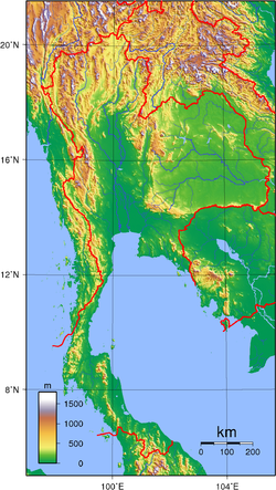
Thailand
Thailand , officially the Kingdom of Thailand , formerly known as Siam , is a country located at the centre of the Indochina peninsula and Southeast Asia. It is bordered to the north by Burma and Laos, to the east by Laos and Cambodia, to the south by the Gulf of Thailand and Malaysia, and to the...
are the Chao Phraya and the Mekong. Together, these rivers support the irrigation for Thailand's agricultural economy. In addition to these two large systems, there are a number of other river systems and individual rivers which drain the lands within Thailand's borders into the Gulf of Thailand
Gulf of Thailand
The Gulf of Thailand , also known in to Malays as Teluk Siam literally meant Gulf of Siam, is a shallow arm of the South China Sea.-Geography:...
and the Andaman Sea
Andaman Sea
The Andaman Sea or Burma Sea is a body of water to the southeast of the Bay of Bengal, south of Burma, west of Thailand and east of the Andaman Islands, India; it is part of the Indian Ocean....
. The Mekong is the only river system in Thailand which drains into the South China Sea
South China Sea
The South China Sea is a marginal sea that is part of the Pacific Ocean, encompassing an area from the Singapore and Malacca Straits to the Strait of Taiwan of around...
.
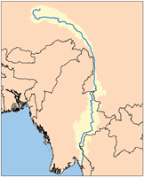
Chao Phraya River System
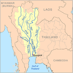
Chao Phraya River
The Chao Phraya is a major river in Thailand, with its low alluvial plain forming the centre of the country. It runs through Bangkok, the capital city, and then empties into the Gulf of Thailand.-Etymology:...
begins at the confluence of the Ping
Ping River
The Ping River , along with the Nan River, is one of the two main contributaries of Chao Phraya River. It originates at Doi Chiang Dao in Chiang Dao district, Chiang Mai Province. After passing Chiang Mai town, it flows though the provinces Lamphun, Tak, and Kamphaeng Phet...
and Nan
Nan River
The Nan River is a river in Thailand. It is one of the most important tributaries of the Chao Phraya River.-Geography:The Nan River originates in Nan Province. The provinces along the river after Nan Province are Uttaradit, Phitsanulok and Phichit. The Yom River joins the Nan River at Chum Saeng...
river at Nakhon Sawan
Nakhon Sawan
Nakhon Sawan is a city in Thailand, the name literally means "Heavenly City". The city is the capital of Nakhon Sawan Province, and covers the complete subdistrict Pak Nam Pho and parts of Khwae Yai, Nakhon Sawan Tok, Nakhon Sawan Ok and Wat Sai, all of Mueang Nakhon Sawan district...
(also called Pak Nam Pho) in the Nakhon Sawan province
Nakhon Sawan Province
Nakhon Sawan is one of the provinces of Thailand. Neighboring provinces are Kamphaeng Phet, Phichit, Phetchabun, Lop Buri, Sing Buri, Chai Nat, Uthai Thani and Tak.- Etymology :...
. It then flows from north to south for 372 km from the central plains
Central Thailand
Central Thailand is a region of Thailand, covering the broad alluvial plain of the Chao Phraya River. It is separated from North-East Thailand by the Phetchabun mountain range, and another mountain range separates it from Myanmar to the west. In the north it gently changes into the more hilly...
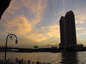
through Bangkok
Bangkok
Bangkok is the capital and largest urban area city in Thailand. It is known in Thai as Krung Thep Maha Nakhon or simply Krung Thep , meaning "city of angels." The full name of Bangkok is Krung Thep Mahanakhon Amon Rattanakosin Mahintharayutthaya Mahadilok Phop Noppharat Ratchathani Burirom...
to the Gulf of Thailand
Gulf of Thailand
The Gulf of Thailand , also known in to Malays as Teluk Siam literally meant Gulf of Siam, is a shallow arm of the South China Sea.-Geography:...
. In Chainat
Chainat Province
Chainat is one of the central provinces of Thailand. Neighboring provinces are Nakhon Sawan, Sing Buri, Suphan Buri and Uthai Thani.-Geography:...
, the river splits into the main river course and the Tha Chin river, which then flows parallel to the main river and exits to Gulf of Thailand at about 35 km west of Bangkok in Samut Sakhon. In the low alluvial plain which begins below the Chainat dam, many small canals (khlong
Khlong
A khlong is the general name for a canal in the central plain of Thailand. These canals are spawned by the Chao Phraya, the Tha Chin, the Mae Klong Rivers and their tributaries...
) split off from the main river. The khlong are used for the irrigation of the region's rice paddies.
Tributaries
The principal tributaries of the Chao Phraya River are the Pa Sak RiverPa Sak River
The Pa Sak River is a river in central Thailand. The river originates in Dan Sai District, Loei Province, passes through Phetchabun Province as the backbone of the Province...
, the Sakae Krang River
Sakae Krang River
The Sakae Krang River is a tributary of the Chao Phraya River. It originates in Mae Wong National Park, Kamphaeng Phet Province. It is 225 km long, with most of its length in Uthai Thani Province...
, the Nan River
Nan River
The Nan River is a river in Thailand. It is one of the most important tributaries of the Chao Phraya River.-Geography:The Nan River originates in Nan Province. The provinces along the river after Nan Province are Uttaradit, Phitsanulok and Phichit. The Yom River joins the Nan River at Chum Saeng...
(along with its principal confluent the Yom River
Yom River
The Yom River is the dime main tributary of the Nan River . The Yom originates in Pong district, Phayao Province, Thailand...
), the Ping River
Ping River
The Ping River , along with the Nan River, is one of the two main contributaries of Chao Phraya River. It originates at Doi Chiang Dao in Chiang Dao district, Chiang Mai Province. After passing Chiang Mai town, it flows though the provinces Lamphun, Tak, and Kamphaeng Phet...
(with its principal confluent the Wang River
Wang River
The Wang River is a river in northern Thailand.-Geography:The Wang River is altogether 335nsnp;km long. Its waters flow from north to south. One of the principal settlements along the river is Lampang, which is situated on the north bank of a curve in the river. From Lampang, the river extends...
), and the Tha Chin River
Tha Chin River
The Tha Chin river is a distributary of the Chao Phraya river, Thailand. It splits near the province of Chainat and then flows westerly from the Chao Phraya through the central plains, until it mouths into the Gulf of Thailand at the province of Samut Sakhon....
.. Each of these tributaries (and the Chao Phraya itself) is further tributed by additional minor tributaries often referred to as khwae. All of the tributaries, including the lesser khwae, form an extensive tree-like pattern, with branches flowing through nearly every province in central and northern Thailand
Thailand
Thailand , officially the Kingdom of Thailand , formerly known as Siam , is a country located at the centre of the Indochina peninsula and Southeast Asia. It is bordered to the north by Burma and Laos, to the east by Laos and Cambodia, to the south by the Gulf of Thailand and Malaysia, and to the...
. None of the tributaries of the Chao Phraya extend beyond the nation's borders. The Nan and the Yom River flow nearly parallel from Phitsanulok
Phitsanulok
Phitsanulok is an important and historic city in lower northern Thailand and is the capital of Phitsanulok Province, which stretches all the way to the Laotian border. Phitsanulok is one of the oldest cities in Thailand, founded over 600 years ago...
to Chumsaeng in the north of Nakhon Sawan province. The Wang River
Wang River
The Wang River is a river in northern Thailand.-Geography:The Wang River is altogether 335nsnp;km long. Its waters flow from north to south. One of the principal settlements along the river is Lampang, which is situated on the north bank of a curve in the river. From Lampang, the river extends...
enters the Ping River near Sam Ngao district in Tak province
Tak Province
Tak is one of the northern provinces of Thailand. Neighboring provinces are Mae Hong Son, Chiang Mai, Lamphun, Lampang, Sukhothai, Kamphaeng Phet, Nakhon Sawan, Uthai Thani and Kanchanaburi...
.
Drainage
The expanse of the Chao Phraya River and its tributaries, i.e. the Chao Phraya river system, together with the land upon which falling rain drains into these bodies of water, form the Chao Phraya watershedDrainage basin
A drainage basin is an extent or an area of land where surface water from rain and melting snow or ice converges to a single point, usually the exit of the basin, where the waters join another waterbody, such as a river, lake, reservoir, estuary, wetland, sea, or ocean...
.
The Chao Phraya watershed is the largest watershed in Thailand, covering approximately 35% of the nation's land, and draining an area of 157,924 km².
Lesser Gulf River Systems
There are numerous rivers which flow into the Gulf of ThailandGulf of Thailand
The Gulf of Thailand , also known in to Malays as Teluk Siam literally meant Gulf of Siam, is a shallow arm of the South China Sea.-Geography:...
, including a number of west coast gulf rivers, east coast gulf rivers, and rivers which drain into the gulf on the east coast of the Malay Peninsula
Malay Peninsula
The Malay Peninsula or Thai-Malay Peninsula is a peninsula in Southeast Asia. The land mass runs approximately north-south and, at its terminus, is the southern-most point of the Asian mainland...
. The following river systems, in addition to the Chao Phraya, are the most significant gulf systems in Thailand:
Bang Pakong
The Bang Pakong River is a riverRiver
A river is a natural watercourse, usually freshwater, flowing towards an ocean, a lake, a sea, or another river. In a few cases, a river simply flows into the ground or dries up completely before reaching another body of water. Small rivers may also be called by several other names, including...
in eastern Thailand
Thailand
Thailand , officially the Kingdom of Thailand , formerly known as Siam , is a country located at the centre of the Indochina peninsula and Southeast Asia. It is bordered to the north by Burma and Laos, to the east by Laos and Cambodia, to the south by the Gulf of Thailand and Malaysia, and to the...
. The river originates at the confluence of the Nakhon Nayok River
Nakhon Nayok River
The Nakhon Nayok River originates in the Khao Yai National park. It flows heading to Southwest, passes the districts Mueang Nakhon Nayok, Ban Na and Ongkharak of Nakhon Nayok Province. It then joins the Prachin Buri River to become the Bang Pakong River in Ban Sang district, Prachinburi Province...
and the Prachinburi River at Pak Nam Yotaka in Amphoe Ban Sang
Amphoe Ban Sang
Ban Sang is the westernmost district of Prachinburi Province, central Thailand.-History:In the past the area of he district was dense forest with many wild elephants. Laotians from Vientiane moved to settle their village in the area, which they named Ban Chang...
, Prachinburi Province
Prachinburi Province
Prachin Buri is a province of Thailand. Neighboring provinces are Nakhon Ratchasima, Sa Kaeo, Chachoengsao and Nakhon Nayok.-Geography:...
. It empties into the Gulf of Thailand
Gulf of Thailand
The Gulf of Thailand , also known in to Malays as Teluk Siam literally meant Gulf of Siam, is a shallow arm of the South China Sea.-Geography:...
in the northeastern tip of the Bay of Bangkok
Bay of Bangkok
The Bay of Bangkok , also known as the Bight of Bangkok, is the northernmost part of the Gulf of Thailand, roughly extending from Hua Hin to the west and Sattahip to the east...
. The Bang Pakong's principal tributaries are the Nakhon Nayok River
Nakhon Nayok River
The Nakhon Nayok River originates in the Khao Yai National park. It flows heading to Southwest, passes the districts Mueang Nakhon Nayok, Ban Na and Ongkharak of Nakhon Nayok Province. It then joins the Prachin Buri River to become the Bang Pakong River in Ban Sang district, Prachinburi Province...
and the Prachin Buri River
Prachin Buri River
The Prachin Buri River begins at the confluence of the Phra Prong, Hanuman and Prachantakham rivers in Amphoe Kabin Buri, Prachin Buri province. It passes Amphoe Si Maha Phot, Mueang Prachinburi and Ban Sang....
. The watershed of the Bang Pakong is about 17,000 km².
Phetchaburi
The Phetchaburi RiverPhetchaburi River
The Phetchaburi River is a river in western Thailand. It originates in Kaeng Krachan National Park, Kaeng Krachan district and flows through Tha Yang, Ban Lat, Mueang Phetchaburi and mouths into the Bay of Bangkok in Ban Laem district. It is 210 km long, most of which is within the...
is a river in western Thailand
Thailand
Thailand , officially the Kingdom of Thailand , formerly known as Siam , is a country located at the centre of the Indochina peninsula and Southeast Asia. It is bordered to the north by Burma and Laos, to the east by Laos and Cambodia, to the south by the Gulf of Thailand and Malaysia, and to the...
. It originates in Kaeng Krachan National Park
Kaeng Krachan National Park
Kaeng Krachan is the largest national park of Thailand, located at the northern end of the Malay Peninsula. Due to its location near the tourist town of Hua Hin it is a popular park.-Geography:...
, Kaeng Krachan district
Amphoe Kaeng Krachan
Kaeng Krachan is a district of Phetchaburi Province, central Thailand.-History:The district was created as a minor district on January 1 1988 by splitting off the three tambon Kaeng Krachan, Song Phi Nong and Wang Chan from Tha Yang district...
and flows through Tha Yang
Amphoe Tha Yang
Tha Yang is a district in the southern part of Phetchaburi Province, central Thailand.- Etymology :In 1910 the western part of the district was mountainous area, covered by dense forest. The main trees are Makha , Takhian and Yang...
, Ban Lat
Amphoe Ban Lat
Ban Lat is a district in the central part of Phetchaburi Province, central Thailand.-Geography:Neighboring districts are Khao Yoi, Mueang Phetchaburi, Tha Yang, Kaeng Krachan and Nong Ya Plong of Phetchaburi Province....
, Mueang Phetchaburi
Amphoe Mueang Phetchaburi
Mueang Phetchaburi is the capital district of Phetchaburi Province, central Thailand.-History:The district was established around 1903...
and mouths into the Bay of Bangkok
Bay of Bangkok
The Bay of Bangkok , also known as the Bight of Bangkok, is the northernmost part of the Gulf of Thailand, roughly extending from Hua Hin to the west and Sattahip to the east...
in Ban Laem district
Amphoe Ban Laem
Ban Laem is a district in the northeastern part of Phetchaburi Province, central Thailand.-History:Originally, the area were Khwaeng Khun Chamnan and Phrommasan under Mueang Phetchaburi district....
. It is 210 km long, most of which is within the Phetchaburi Province
Phetchaburi Province
Phetchaburi is one of the central provinces of Thailand. Neighboring provinces are Ratchaburi, Samut Songkhram and Prachuap Khiri Khan...
. It is the backbone of this province.
Mae Klong
The Mae Klong River is a river in western ThailandThailand
Thailand , officially the Kingdom of Thailand , formerly known as Siam , is a country located at the centre of the Indochina peninsula and Southeast Asia. It is bordered to the north by Burma and Laos, to the east by Laos and Cambodia, to the south by the Gulf of Thailand and Malaysia, and to the...
. The river begins at the confluence of the Khwae Noi or Kwai Sai Yoke and the Khwae Yai River
Khwae Yai River
The Khwae Yai River , also known as the Si Sawat , is a river in western Thailand. It flows for about 380 kilometres through Sangkhla Buri, Si Sawat, and Mueang Districts of Kanchanaburi Province, where it merges with the Khwae Noi to form the Mae Klong River at Pak Phraek subdistrict.The famous...
or Kwai Si Sawasdi in Kanchanaburi
Kanchanaburi
Kanchanaburi ) is a town in the west of Thailand and the capital of Kanchanaburi province. In 2006 it had a population of 31,327...
, pass Ratchaburi Province
Ratchaburi Province
Ratchaburi is one of the central provinces of Thailand. Neighboring provinces are Kanchanaburi, Nakhon Pathom,Samut Sakhon, Samut Songkhram and Phetchaburi...
and empties into the Gulf of Thailand
Gulf of Thailand
The Gulf of Thailand , also known in to Malays as Teluk Siam literally meant Gulf of Siam, is a shallow arm of the South China Sea.-Geography:...
in Samut Songkhram
Samut Songkhram
Samut Songkhram ) is a town in Thailand, capital of the Samut Songkhram Province and the Samut Songkhram district. It covers the area of the tambon Mae Klong, which is also the old name of the town as well as the Mae Klong River, which enters the Gulf of Thailand near the town....
.
Pran Buri
The Pran Buri River is a river in the Prachuap Khiri Khan ProvincePrachuap Khiri Khan Province
Prachuap Khiri Khan is one of the central provinces of Thailand. Neighboring provinces are Phetchaburi in the north and Chumphon in the south. To the west it borders Tanintharyi Division of Myanmar....
, Thailand
Thailand
Thailand , officially the Kingdom of Thailand , formerly known as Siam , is a country located at the centre of the Indochina peninsula and Southeast Asia. It is bordered to the north by Burma and Laos, to the east by Laos and Cambodia, to the south by the Gulf of Thailand and Malaysia, and to the...
, on the Kra Isthmus
Kra Isthmus
The Kra Isthmus is the narrow land bridge which connects the Malay Peninsula with the mainland of Asia, and popularly named "The Devil's Neck".-Geography:...
of the Malay Peninsula
Malay Peninsula
The Malay Peninsula or Thai-Malay Peninsula is a peninsula in Southeast Asia. The land mass runs approximately north-south and, at its terminus, is the southern-most point of the Asian mainland...
. The Pran Buri river originates in southern part of the Kaeng Krachan National Park
Kaeng Krachan National Park
Kaeng Krachan is the largest national park of Thailand, located at the northern end of the Malay Peninsula. Due to its location near the tourist town of Hua Hin it is a popular park.-Geography:...
, and after 130 km mouths into the Gulf of Thailand
Gulf of Thailand
The Gulf of Thailand , also known in to Malays as Teluk Siam literally meant Gulf of Siam, is a shallow arm of the South China Sea.-Geography:...
. The only town at the river course is Pranburi, the center of the Pran Buri district
Amphoe Pran Buri
Pran Buri is a district in the northern part of Prachuap Khiri Khan Province, central Thailand.-History:Mueang Pran was a city in the southern cities group of Ayutthaya kingdom. In the reign of King Mongkut , the governor of Mueang Pran had full authorised administrative...
. The watershed of the Pran Buri River has an area of about 2000 km².
Khlong Kui
The Khlong Kui RiverKhlong Kui
-Geography:The Khlong Kui drains into the Gulf of Thailand from the Malay Peninsula in Thailand. It flows through Ban Pong Kasang and Ban Thung Faek, Kui Buri district, Prachuap Khiri Khan Province.-References:...
drains into the Gulf of Thailand
Gulf of Thailand
The Gulf of Thailand , also known in to Malays as Teluk Siam literally meant Gulf of Siam, is a shallow arm of the South China Sea.-Geography:...
from the Malay Peninsula
Malay Peninsula
The Malay Peninsula or Thai-Malay Peninsula is a peninsula in Southeast Asia. The land mass runs approximately north-south and, at its terminus, is the southern-most point of the Asian mainland...
in Thailand. It flows through Ban Pong Kasang and Ban Thung Faek, Kui Buri district
Amphoe Kui Buri
Kui Buri is a district in the northern part of Prachuap Khiri Khan Province, central Thailand.-History:Mueang Kui was an ancient city of Ayutthaya kingdom. In the reign of King Boromakot, Kui was 4th class city. The governor position was Phra Kui Buri. In Rattanakosin, King Rama II established a...
, Prachuap Khiri Khan Province
Prachuap Khiri Khan Province
Prachuap Khiri Khan is one of the central provinces of Thailand. Neighboring provinces are Phetchaburi in the north and Chumphon in the south. To the west it borders Tanintharyi Division of Myanmar....
.
Tapi and Phum Duang
The Tapi RiverTapi River, Thailand
The Tapi river is the longest river in southern Thailand. The river originates at the Khao Luang, and has a wide estuary into the Gulf of Thailand at Bandon Bay near the town of Surat Thani. It has a length of 230 km....
with its main tributary Phum Duang
Phum Duang River
The Phum Duang River is a river in Surat Thani Province, Southern Thailand, the main tributary of the Tapi River....
drain the area of Surat Thani Province
Surat Thani Province
Surat Thani is the largest of the southern provinces of Thailand, on the eastern shore of the Gulf of Thailand. Surat Thani means City of Good People, the title given to the city by King Vajiravudh ....
. The total watershed of the river system is about 11,500 km².
Pattani
The Pattani RiverPattani River
Pattani River is a river in Southern Thailand, Thailand. It originates in Betong district, Yala Province and mouths into the Gulf of Thailand at the town Pattani. Within Yala province the river forms the Bang Lang Reservoir. The river has a length of 214 km....
is the longest of all Thai rivers on the Malay Peninsula with a total length of 214 km.
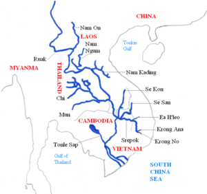
Mekong River System
River
A river is a natural watercourse, usually freshwater, flowing towards an ocean, a lake, a sea, or another river. In a few cases, a river simply flows into the ground or dries up completely before reaching another body of water. Small rivers may also be called by several other names, including...
s, drains into the South China Sea
South China Sea
The South China Sea is a marginal sea that is part of the Pacific Ocean, encompassing an area from the Singapore and Malacca Straits to the Strait of Taiwan of around...
. It is the 11th-longest river in the world, and the 12th-largest by volume (discharging 475 km³ of water annually). Its estimated length is 4880 km, and it drains an area of 810,000 km². From the Tibetan Plateau
Tibetan Plateau
The Tibetan Plateau , also known as the Qinghai–Tibetan Plateau is a vast, elevated plateau in Central Asia covering most of the Tibet Autonomous Region and Qinghai, in addition to smaller portions of western Sichuan, southwestern Gansu, and northern Yunnan in Western China and Ladakh in...
it runs through China
China
Chinese civilization may refer to:* China for more general discussion of the country.* Chinese culture* Greater China, the transnational community of ethnic Chinese.* History of China* Sinosphere, the area historically affected by Chinese culture...
's Yunnan
Yunnan
Yunnan is a province of the People's Republic of China, located in the far southwest of the country spanning approximately and with a population of 45.7 million . The capital of the province is Kunming. The province borders Burma, Laos, and Vietnam.Yunnan is situated in a mountainous area, with...
province, Myanmar
Myanmar
Burma , officially the Republic of the Union of Myanmar , is a country in Southeast Asia. Burma is bordered by China on the northeast, Laos on the east, Thailand on the southeast, Bangladesh on the west, India on the northwest, the Bay of Bengal to the southwest, and the Andaman Sea on the south....
, Thailand
Thailand
Thailand , officially the Kingdom of Thailand , formerly known as Siam , is a country located at the centre of the Indochina peninsula and Southeast Asia. It is bordered to the north by Burma and Laos, to the east by Laos and Cambodia, to the south by the Gulf of Thailand and Malaysia, and to the...
, Laos
Laos
Laos Lao: ສາທາລະນະລັດ ປະຊາທິປະໄຕ ປະຊາຊົນລາວ Sathalanalat Paxathipatai Paxaxon Lao, officially the Lao People's Democratic Republic, is a landlocked country in Southeast Asia, bordered by Burma and China to the northwest, Vietnam to the east, Cambodia to the south and Thailand to the west...
, Cambodia
Cambodia
Cambodia , officially known as the Kingdom of Cambodia, is a country located in the southern portion of the Indochina Peninsula in Southeast Asia...
and Vietnam
Vietnam
Vietnam – sometimes spelled Viet Nam , officially the Socialist Republic of Vietnam – is the easternmost country on the Indochina Peninsula in Southeast Asia. It is bordered by China to the north, Laos to the northwest, Cambodia to the southwest, and the South China Sea –...
. All except China and Myanmar belong to the Mekong River Commission
Mekong River Commission
The Mekong River Commission is an intergovernment body charged “to promote and co-ordinate sustainable management and development of water and related resources for the countries’ mutual benefit and the people’s well-being by implementing strategic programmes and activities and providing...
. The extreme seasonal variations in flow and the presence of rapid
Rapid
A rapid is a section of a river where the river bed has a relatively steep gradient causing an increase in water velocity and turbulence. A rapid is a hydrological feature between a run and a cascade. A rapid is characterised by the river becoming shallower and having some rocks exposed above the...
s and waterfall
Waterfall
A waterfall is a place where flowing water rapidly drops in elevation as it flows over a steep region or a cliff.-Formation:Waterfalls are commonly formed when a river is young. At these times the channel is often narrow and deep. When the river courses over resistant bedrock, erosion happens...
s have made navigation
Navigation
Navigation is the process of monitoring and controlling the movement of a craft or vehicle from one place to another. It is also the term of art used for the specialized knowledge used by navigators to perform navigation tasks...
extremely difficult. Approximately half the river's length is in China, where it is known as the Lancang Jiang (澜沧江 Láncāng Jiāng) or Meigong in Chinese . The river next forms the border between Myanmar and Laos for 200 km, at the end of which it meets the tributary
Tributary
A tributary or affluent is a stream or river that flows into a main stem river or a lake. A tributary does not flow directly into a sea or ocean...
Ruak River
Ruak River
The Ruak River is a river at the Thai-Burma border. It originates within the hills of the Shan State , and becomes the boundary river between Thailand and Burma at the confluence with the Mae Sai River at the northernmost point of Thailand. It then meanders to the east until it empties into the...
at the Golden Triangle
Golden Triangle (Southeast Asia)
The Golden Triangle is one of Asia's two main illicit opium-producing areas. It is an area of around that overlaps the mountains of four countries of Southeast Asia: Burma, Vietnam, Laos, and Thailand. Along with Afghanistan in the Golden Crescent and Pakistan, it has been one of the most...
. This point also marks the division between the Upper and Lower Mekong. The river then divides Laos and Thailand, before a stretch passing through Laos alone. It is known as Maè Nam Khong (Mother of all rivers) in both Lao
Lao language
Lao or Laotian is a tonal language of the Tai–Kadai language family. It is the official language of Laos, and also spoken in the northeast of Thailand, where it is usually referred to as the Isan language. Being the primary language of the Lao people, Lao is also an important second language for...
and Thai
Thai language
Thai , also known as Central Thai and Siamese, is the national and official language of Thailand and the native language of the Thai people, Thailand's dominant ethnic group. Thai is a member of the Tai group of the Tai–Kadai language family. Historical linguists have been unable to definitively...
(แม่น้ำโขง). The river again marks the Lao-Thai border in the stretch which passes Vientiane
Vientiane
-Geography:Vientiane is situated on a bend of the Mekong river, which forms the border with Thailand at this point.-Climate:Vientiane features a tropical wet and dry climate with a distinct monsoon season and a dry season. Vientiane’s dry season spans from November through March. April marks the...
, followed by a short stretch through Laos alone. In Cambodia, the river is called the Mékôngk or Tonle Thom (great river). Just above Phnom Penh
Phnom Penh
Phnom Penh is the capital and largest city of Cambodia. Located on the banks of the Mekong River, Phnom Penh has been the national capital since the French colonized Cambodia, and has grown to become the nation's center of economic and industrial activities, as well as the center of security,...
is the confluence with the Tonle Sap
Tonlé Sap
The Tonlé Sap is a combined lake and river system of major importance to Cambodia.The Tonlé Sap is the largest freshwater lake in South East Asia and is an ecological hot spot that was designated as a UNESCO biosphere in 1997....
, the main Cambodian tributary. Below Phnom Penh, it divides into the Bassac
Bassac River
The Bassac River is a distributary of the Tonle Sap and Mekong River. The river starts in Phnom Penh, Cambodia, and flows southerly, crossing the border into Vietnam near Châu Đốc....
and the Mekong proper, which both flow into the Mekong Delta
Mekong Delta
The Mekong Delta is the region in southwestern Vietnam where the Mekong River approaches and empties into the sea through a network of distributaries. The Mekong delta region encompasses a large portion of southwestern Vietnam of . The size of the area covered by water depends on the season.The...
in Vietnam. In Vietnamese
Vietnamese language
Vietnamese is the national and official language of Vietnam. It is the mother tongue of 86% of Vietnam's population, and of about three million overseas Vietnamese. It is also spoken as a second language by many ethnic minorities of Vietnam...
, the river as a whole is known as Mê Kông. In Vietnam, the river divides into two major branches, the Tiền Giang (Front River) and Hậu Giang (Back River). These in turn enter the South China Sea through nine estuaries.
Thai Tributaries
The following are the principal tributaries of Mekong River which flow through Thailand (tributaries entirely outside the Thai border not shown).- Ing RiverIng RiverThe Ing River is a tributary of the Mekong River in the northern part of Thailand. It is about 300 km long and its flow varies seasonally due to the tropical forest climate in the region. Flood waters inundate the river basin during the rainy season, spurring migratory fish to enter the Ing...
(joins the Mekong in Thailand) - Ruak RiverRuak RiverThe Ruak River is a river at the Thai-Burma border. It originates within the hills of the Shan State , and becomes the boundary river between Thailand and Burma at the confluence with the Mae Sai River at the northernmost point of Thailand. It then meanders to the east until it empties into the...
(joins the Mekong in Thailand) - Mun RiverMun RiverThe Mun River , sometimes spelled Moon River, is a tributary of the Mekong river. It carries approximately 21,000 cubic kilometres of water per year.-Geography:...
(joins the Mekong in Thailand)- Chi RiverChi RiverThe Chi River is the longest river in Thailand; it extends 765 km, but carries less water than the second longest river, the Mun. In the Isan dialect of this region, and also in the adjacent language Lao, the name of the river is actually pronounced "Nam Si" but the transliteration Chi...
(joins the Mun in Thailand) - Dom Noi RiverDom Noi RiverThe Dom Noi River is a tributary of the Mun River, originates in the Dongrek mountains and flows northwards. The river passes Buntharik district and is stopped by the Sirindhorn Dam in Tambon Chong Mek, Sirindhorn district. It is 150 km long....
(joins the Mun in Thailand) - Lam Ta Klong RiverLam Ta Klong River-Geography:The Lam Ta Klong is a tributary of the Mun River. Its source lies within the Khao Yai National Park. The Lam Ta Klong joins the Mun River just east of Nakhon Ratchasima.-Significance:...
(joins the Mun in Thailand)
- Chi River
- Kok RiverKok RiverThe Kok River originates in Shan State, Burma. It flows down and across the Burma-Thailand border to Mae Ai district, Chiang Mai Province, passing under Phahonyothin Road. Most of its length is in Chiang Rai Province passing the districts Mueang Chiang Rai, Mae Chan, Chiang Saen and Wiang Chai. It...
(joins the Mekong in Thailand) - Tonlé Sap RiverTonlé SapThe Tonlé Sap is a combined lake and river system of major importance to Cambodia.The Tonlé Sap is the largest freshwater lake in South East Asia and is an ecological hot spot that was designated as a UNESCO biosphere in 1997....
(joins the Mekong in Cambodia, but extends into Thailand)
Drainage
The Mekong drains a considerable portion of northeast Thailand. In terms of Thai land area drained, it is second only to the Chao Phraya system.Salawin River System
Salween River
The Salween is a river, about long, that flows from the Tibetan Plateau into the Andaman Sea in Southeast Asia. It drains a narrow and mountainous watershed of that extends into the countries China, Burma and Thailand. Steep canyon walls line the swift, powerful and undammed Salween, one of the...
rises in Tibet
Tibet
Tibet is a plateau region in Asia, north-east of the Himalayas. It is the traditional homeland of the Tibetan people as well as some other ethnic groups such as Monpas, Qiang, and Lhobas, and is now also inhabited by considerable numbers of Han and Hui people...
(Tibetan [རྒྱལ་མོ་རྔུལ་ཆུ།]http://tibetanecology.org/Seven_River_Map.htm) after which it flows through Yunnan
Yunnan
Yunnan is a province of the People's Republic of China, located in the far southwest of the country spanning approximately and with a population of 45.7 million . The capital of the province is Kunming. The province borders Burma, Laos, and Vietnam.Yunnan is situated in a mountainous area, with...
, where it is known as the Nujiang river , although either name can be used for the whole river. The river is 2815 km long. It then leaves China
China
Chinese civilization may refer to:* China for more general discussion of the country.* Chinese culture* Greater China, the transnational community of ethnic Chinese.* History of China* Sinosphere, the area historically affected by Chinese culture...
and meanders through Myanmar
Myanmar
Burma , officially the Republic of the Union of Myanmar , is a country in Southeast Asia. Burma is bordered by China on the northeast, Laos on the east, Thailand on the southeast, Bangladesh on the west, India on the northwest, the Bay of Bengal to the southwest, and the Andaman Sea on the south....
(where it is known as the Thanlwin) and Thailand
Thailand
Thailand , officially the Kingdom of Thailand , formerly known as Siam , is a country located at the centre of the Indochina peninsula and Southeast Asia. It is bordered to the north by Burma and Laos, to the east by Laos and Cambodia, to the south by the Gulf of Thailand and Malaysia, and to the...
(where it is known as the Salawin, Thai: สาละวิน) on its way to emptying in the Andaman Sea
Andaman Sea
The Andaman Sea or Burma Sea is a body of water to the southeast of the Bay of Bengal, south of Burma, west of Thailand and east of the Andaman Islands, India; it is part of the Indian Ocean....
by Mawlamyaing (Moulmien).
Thai Tributaries
The principal tributaries of the Salawin which flow through Thailand are the Moei RiverMoei River
The Moei River is a tributary of the Salween River. It originates in Phop Phra district, Tak Province. Unlike most rivers in Thailand, it flows north. The river forms the natural border line between Thailand and Burma...
and the Pai River
Pai River
The Pai River originates in mountainous Pai, Mae Hong Son Province. The river flows down to Mueang Mae Hong Son district. The river tributes the Salween River in Kayah State, Myanmar. It is 180 km long. Located close to the Myanmar border, the Pai river offers several rafting options. The...
.
Other Andaman Sea Rivers
In addition to the Salween River, there are a number of rivers which drain into the Andaman Sea from the west coast of the Malay PeninsulaMalay Peninsula
The Malay Peninsula or Thai-Malay Peninsula is a peninsula in Southeast Asia. The land mass runs approximately north-south and, at its terminus, is the southern-most point of the Asian mainland...
. None of them are significantly extensive, however, to be considered river systems.