

Ratchaburi Province
Encyclopedia
Ratchaburi is one of the central provinces
(changwat) of Thailand
. Neighboring provinces are (from north clockwise) Kanchanaburi
, Nakhon Pathom
,
Samut Sakhon
, Samut Songkhram
and Phetchaburi
. In the west it borders Tanintharyi Division
of Myanmar.
Ratchaburi means, "The land of the king."
The province is full of cultural heritage, beautiful landscapes and historical sites.
It is located 80 kilometers west of Bangkok
and borders Burma to the west with the Tanaosi Range as a natural borderline.
The Mae Klong River flows through the center of Ratchaburi town.
word Raja meaning King
or Royal, and the word buri from Sanskrit Puri meaning town
or city
. Hence the name of the province literally means Royal City.
 Ratchaburi Province covers 5200 square kilometers. The east part of the province contains the flat river plains of the Mae Klong
river, crisscrossed by many khlong
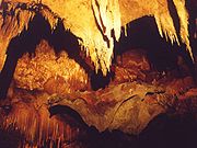
s. The most famous tourist spot in this area are the floating markets of Damnoen Saduak. The west of the province is more mountainous, and includes the Tanawsri mountain range. As the mountains are made mostly of limestone
, there are several caves containing stalactite
s. Some caves are inhabited by large colonies of bat
s, and it is an impressive sight when they swarm out in the evening to feed. Other caves like the Khao Bin are accessible for visitors. The main river of the west part is the Phachi River
.
At the left bank of the Phachi river the Chaloem Phra Kiat Thai Prachan National Park is in process of being established since 2003: It is scheduled to protect 384.39 km² of forests which had been battle ground with the Communist party of Thailand
in the past.
Ratchaburi Province is about 100 kilometres (62.1 mi) west of Bangkok
.
 The history of the city of Ratchaburi dates back to the Dvaravati
period, when it was an important city of the Mon kingdom. Of the contemporary city Khu Bua
nearby only ruins remains. According to legend it even dates back to the mythical Suvannabhumi
kingdom predating Dvaravati.
living near the boundary to Myanmar. Also some Mon
, Lawa
, Lao
, Chinese
and Khmer
minorities live in the province.
shows the royal sword
above the royal sandals on a phan (tray)
, as the name Ratchaburi means City of the King. The name derives from the fact that King Rama I was born here. The provincial slogan is Beautiful women of Photharam, beautiful women of Baan Pong, the city of earthen jars, shadow plays at Wat Khanon, magnificent caves, floating market at Damnoen, bats, delicious Yii Sok fish.
The provincial flower is the Pink Shower Tree (Cassia bakeriana), and the provincial tree is Wrightia pubescens.
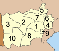 The province is subdivided into 10 districts (amphoe
). The districts are further subdivided into 104 subdistricts (tambon
) and 935 villages (muban
).
There are three towns (thesaban mueang) - Ratchaburi, Ban Pong
and Photharam - and 11 township (thesaban tambon).
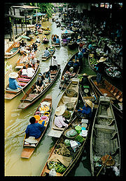 Ratchaburi has lots of places to visit and the most popular tourist attraction
is Damnoen Saduak Floating Market.
It is an identity of Ratchaburi and is also well known around the world.
Damnoen Saduak Floating Market is in the Damnoen Saduak district.
It shows the people's life style and the importance of the river as a mean of commerce.
The vendors would paddle their boats up and down the waterways selling and bartering their merchandise.
Their faces are often shielded from the strong rays of the sun by hats made from bamboo and palm leaves. The markets start in very early morning until 11:00 A.M.
Nowadays, many tourists from around the world come to visit
because it shows an old fascinating style traditions.
That is why the Damnoen Saduak Floating Market became the top ten famous places in Thailand.
There are many famous tourist attractions in Ratchaburi
that showcase the Thai culture, tradition, and way of life.
Tourist can experience the authentic Thai culture by visiting these attractions.
The most interesting place for tourists who are interested in Thai art is the temple.
Unlike other countries, Thailand has its own identity style temple, which is gentle and splendid.
Wat Phra Si Ratana Mahathat - is an ancient temple, locally called Wat Na Phra That,
is located on the west bank of the Mae Klong River in the town.
Its elegant prangs or pagoda remains in good condition and was probably
copied from Cambodia's Angkor Wat. The beautiful prang made of bricks and
a stone stands on a rectangular base with pathways around the cloisters.
The outer stucco designs were made in the reign of King Borommakot of Ayutthaya.
Buddha images of Dvaravati, Lop Buri and Ayutthaya periods are placed around the pagoda.
The temple is the most famous temple in Ratchaburi because it is the first temple
and it has a fascinated architecture.
Murals of Wat Khongkharam - at a Mon monastery over 200 years old and originally called "Wat Klang" or "Phia To". King Mongkut gave it a new name as "Wat Khongkharam". It is located in Amphoe Photharam, some 22 kilometers from Ratchaburi.
The beauty of the main shrine hall is very interesting and good for studying about mural paintings.
Nang Yai at Wat Khanon - Nang Yai is located in Amphoe Photharam and it is well preserved at this place only.
It is an old form of entertainment which gathers many kinds of arts, for example Thai designs, sculpturing, male performers plus music, mask playing and Thai literature. This is a beauty which is portrayed on the screen and it can dance beautifully to the music and the one who makes it dance. At present, Ratchaburi province is organizing a Nang Yai performance for tourists. There are about 330 Nang Yai puppets all of which are still in perfect condition to be shown on screen.
In addition, Ratchaburi has many natural tourist attractions
Bo Khloung Hot Stream - is located five kilometers beyond Amphoe Suan Phung.
The stream is full of mineral water. The water flows all year round from the Tanaosi Range.
Its temperature ranges between 50-68 degree Celsius. On the route to the hot stream, a three kilometers branch road leads to Namtok (waterfall)Kao Chon, which consists of 9 cascades. The waterfall is plentiful during the late rainy season. Many people come to here; they believe that it can be used for skin treatment.
Kaew Chan Waterfall or Nine-Level waterfall - is one kilometer from Bo Khlung hot stream.
Kaew Chan Waterfall’s name was given by Princess Sirindhorn.
As the name indicates, the water cascades from the ninth level and
down the central valley of steep cliff, especially during the rainy season
when there is always a lot of water at the top level.
It is possible to walk up to the ninth level and takes about two hours.
 Pong Yub - is located at Ban Tha Kheay, turn left about five kilometers before the town center and go straight ahead for further five kilometers. The subsidence of the ground has created a steep cliff similar to the one in Pae Muang Phi in Phrae Province.
Khao Bin Cave - is located about 22 kilometres from Ratchaburi city centre is
the mountain range of "Khao Bin", or "Flying Mount"
which is home to the cave of the same name.
Inside the cave there is incomparable stalagmites and stalactites.
It was one of these stalagmites in the shape of a majestic giant eagle
with its wings outspread which gave the cave its name.
Also inside the cave there is a small mineral spring which villagers believe is sacred. Nowadays, illumination by coloured lights helps enhance visitors' view and enjoyment.
Khao Wang - It is a hill that is about 44 metres high and was originally called "Khao Sattanat".
It is located two kilometers west of the town. King Rama V had commanded a palace
to be built on the hill and made a royal visit to receive the Portuguese minister in 1887.
The palace area was donated by King Rama VII to be used as a monastery,
which was later called "Wat Khao Wang".
Tourist can get to the hill by cable cars and see from the top how beautiful Ratchburi is.
This area is known for famous floating market that comes alive with a fair featuring
some typical and unusual avtivities.
These include a Thai cooking competition, a “sea-boxing” competition, boating competition,
as well as local product sales including fruits and Thai sweets and agricultural exhibitions.
Ratchaburi is a land of rich and varied culture and origin,
much of which has been preserved and can still be seen today.
Amongst the things of interest are the histories, the way of life,
the culture, and the natural beauty including caves, streams, forests and mountains.
This is why Ratchaburi is still a popular place to visit in Thailand.
Ratchaburi Tourism Fair (งานเที่ยวราชบุรี) - is held every year during February–March on the ground of the City Hall. Activities include demonstrations of famous handicrafts, such as jar making and "Sin Tin Chok" cloth weaving, the selling of OTOP products and agricultural produce, and folk art and cultural performances by local tribal groups.
Sweet Grape and Damnoen Saduak Floating Market Week Fair (งานเทศกาลองุ่นหวานและตลาดน้ำดำเนินสะดวก) - is held around March–April of every year to introduce agricultural produce to the market, especially grapes which most people grow in Amphoe Damnoen Saduak. Damnoen Saduak Grape is famous for its sweetness and good taste. This fair features the beauty contest of Thida A-ngun Wan and the competition of quality agricultural products.
Khao Ho or Ang Mi Thong Festival (ประเพณีกินข้าวห่อ หรือ อั๊งหมี่ทอง) - is a Su Khwan ceremony or the blessing ceremony for happiness and longevity in life, held around the ninth lunar month. Karens believe that the ninth lunar month is a bad time when ghosts and evil hunt and eat "Khwan" -spirit -of people, so those people may get sick or die. Normally, this ceremony is often held on the full moon day of the ninth lunar month, but if some families are not convenient, they can change to any day in the ninth month. In the ceremony, people boil "Khao Ho" which is sticky rice molded and wrapped in a cone shape; then they will boil it like Khanom Chang. In the past, they ate Khao Ho by dipping it in honey but at present they often dip it in sliced coconut. On the day they boil Khao Ho, the Su Khwan Ceremony will be held, too. It starts with poking a wooden plate and blowing a Khaen for entertainment; then the elders in each family will tie red threads on the children’s wrists and give a blessing for good luck.
Provinces of Thailand
Thailand is divided into 76 provinces , which are geographically grouped into 6 regions. The capital Bangkok is not a province but a special administrative area and is included as the 77th province since it is administered at the same level as the other 76 provinces. The name of the provinces are...
(changwat) of Thailand
Thailand
Thailand , officially the Kingdom of Thailand , formerly known as Siam , is a country located at the centre of the Indochina peninsula and Southeast Asia. It is bordered to the north by Burma and Laos, to the east by Laos and Cambodia, to the south by the Gulf of Thailand and Malaysia, and to the...
. Neighboring provinces are (from north clockwise) Kanchanaburi
Kanchanaburi Province
- History :Archaeology found in Kanchanaburi dates back to the 4th century which proves of trade with surrounding countries even in that time. Very little is also historically known about the actual Khmer influence in Kanchanaburi but there is evidence of their occupation with Prasat Muang Singh –...
, Nakhon Pathom
Nakhon Pathom Province
Nakhon Pathom ) is one of the central provinces of Thailand. Neighboring provinces are Suphan Buri, Ayutthaya, Nonthaburi, Bangkok, Samut Sakhon, Ratchaburi and Kanchanaburi...
,
Samut Sakhon
Samut Sakhon Province
Samut Sakhon ) is one of the central provinces of Thailand.Neighboring provinces are Samut Songkhram, Ratchaburi, Nakhon Pathom and Bangkok.- Etymology :...
, Samut Songkhram
Samut Songkhram Province
Samut Songkhram ) is one of the central provinces of Thailand.Neighboring provinces are Phetchaburi, Ratchaburi and Samut Sakhon. Local people call Samut Songkhram Mae Klong. The province is the smallest of all Thai provinces areawise...
and Phetchaburi
Phetchaburi Province
Phetchaburi is one of the central provinces of Thailand. Neighboring provinces are Ratchaburi, Samut Songkhram and Prachuap Khiri Khan...
. In the west it borders Tanintharyi Division
Tanintharyi Division
Tanintharyi Region , is an administrative region of Myanmar, covering the long narrow southern part of the country on the Kra Isthmus. It borders with the Andaman Sea to the west and with the Tenasserim Hills, beyond which lies Thailand, to the east. To the north is the Mon State. The capital of...
of Myanmar.
Ratchaburi means, "The land of the king."
The province is full of cultural heritage, beautiful landscapes and historical sites.
It is located 80 kilometers west of Bangkok
Bangkok
Bangkok is the capital and largest urban area city in Thailand. It is known in Thai as Krung Thep Maha Nakhon or simply Krung Thep , meaning "city of angels." The full name of Bangkok is Krung Thep Mahanakhon Amon Rattanakosin Mahintharayutthaya Mahadilok Phop Noppharat Ratchathani Burirom...
and borders Burma to the west with the Tanaosi Range as a natural borderline.
The Mae Klong River flows through the center of Ratchaburi town.
Etymology
The word Ratch originates from the SanskritSanskrit
Sanskrit , is a historical Indo-Aryan language and the primary liturgical language of Hinduism, Jainism and Buddhism.Buddhism: besides Pali, see Buddhist Hybrid Sanskrit Today, it is listed as one of the 22 scheduled languages of India and is an official language of the state of Uttarakhand...
word Raja meaning King
King
- Centers of population :* King, Ontario, CanadaIn USA:* King, Indiana* King, North Carolina* King, Lincoln County, Wisconsin* King, Waupaca County, Wisconsin* King County, Washington- Moving-image works :Television:...
or Royal, and the word buri from Sanskrit Puri meaning town
Town
A town is a human settlement larger than a village but smaller than a city. The size a settlement must be in order to be called a "town" varies considerably in different parts of the world, so that, for example, many American "small towns" seem to British people to be no more than villages, while...
or city
City
A city is a relatively large and permanent settlement. Although there is no agreement on how a city is distinguished from a town within general English language meanings, many cities have a particular administrative, legal, or historical status based on local law.For example, in the U.S...
. Hence the name of the province literally means Royal City.
Geography
Mae Klong
The Mae Klong is a river in western Thailand. The river begins at the confluence of the Khwae Noi or Khwae Sai Yok and the Khwae Yai River or Khwae Si Sawat in Kanchanaburi, pass Ratchaburi Province and empties into the Gulf of Thailand in Samut Songkhram....
river, crisscrossed by many khlong
Khlong
A khlong is the general name for a canal in the central plain of Thailand. These canals are spawned by the Chao Phraya, the Tha Chin, the Mae Klong Rivers and their tributaries...
s. The most famous tourist spot in this area are the floating markets of Damnoen Saduak. The west of the province is more mountainous, and includes the Tanawsri mountain range. As the mountains are made mostly of limestone
Limestone
Limestone is a sedimentary rock composed largely of the minerals calcite and aragonite, which are different crystal forms of calcium carbonate . Many limestones are composed from skeletal fragments of marine organisms such as coral or foraminifera....
, there are several caves containing stalactite
Stalactite
A stalactite , "to drip", and meaning "that which drips") is a type of speleothem that hangs from the ceiling of limestone caves. It is a type of dripstone...
s. Some caves are inhabited by large colonies of bat
Bat
Bats are mammals of the order Chiroptera "hand" and pteron "wing") whose forelimbs form webbed wings, making them the only mammals naturally capable of true and sustained flight. By contrast, other mammals said to fly, such as flying squirrels, gliding possums, and colugos, glide rather than fly,...
s, and it is an impressive sight when they swarm out in the evening to feed. Other caves like the Khao Bin are accessible for visitors. The main river of the west part is the Phachi River
Phachi River
The Phachi River is a river in western Thailand. It originates in the Tenasserim Hills in Ban Kha district and passes Suan Phueng and Chom Bueng districts, Ratchaburi Province. The river tributes to the River Kwai in Mueang Kanchanaburi district, Kanchanaburi Province....
.
At the left bank of the Phachi river the Chaloem Phra Kiat Thai Prachan National Park is in process of being established since 2003: It is scheduled to protect 384.39 km² of forests which had been battle ground with the Communist party of Thailand
Communist Party of Thailand
The Communist Party of Thailand - CPT was a Marxist-Leninist, Communist political party in Thailand, active from 1942 until the 1990s. Initially known as Communist Party of Siam the party was founded officially on the 1st of December 1942, although communist activism in the country began as early...
in the past.
Ratchaburi Province is about 100 kilometres (62.1 mi) west of Bangkok
Bangkok
Bangkok is the capital and largest urban area city in Thailand. It is known in Thai as Krung Thep Maha Nakhon or simply Krung Thep , meaning "city of angels." The full name of Bangkok is Krung Thep Mahanakhon Amon Rattanakosin Mahintharayutthaya Mahadilok Phop Noppharat Ratchathani Burirom...
.
History
Dvaravati
The Dvaravati period lasted from the 6th to the 13th centuries. Dvaravati refers to both a culture and a disparate conglomerate of principalities.- History :...
period, when it was an important city of the Mon kingdom. Of the contemporary city Khu Bua
Khu Bua
Khu Bua is an archaeological site 12 km southeast of the town Ratchaburi, Thailand. It dates from the 6th century Dvaravati culture and was one of major cities of this kingdom....
nearby only ruins remains. According to legend it even dates back to the mythical Suvannabhumi
Suwannaphum
' , , is the name of a land mentioned in many ancient sources such as the Chronicle of Sri Lanka , some stories of the Jatakas, and Milinda Panha...
kingdom predating Dvaravati.
Demographics
1.1% of the population are members of the hill tribes, mostly KarenKaren people
The Karen or Kayin people , are a Sino-Tibetan language speaking ethnic group which resides primarily in southern and southeastern Burma . The Karen make up approximately 7 percent of the total Burmese population of approximately 50 million people...
living near the boundary to Myanmar. Also some Mon
Mon people
The Mon are an ethnic group from Burma , living mostly in Mon State, Bago Division, the Irrawaddy Delta, and along the southern Thai–Burmese border. One of the earliest peoples to reside in Southeast Asia, the Mon were responsible for the spread of Theravada Buddhism in Burma and Thailand...
, Lawa
Lawa people
Lawa are an ethnic group in Laos and northern Thailand. They lived there before Thai people arrived. Today they live often in their traditional way of life, often professing animism. As the other mountain ethnic groups of Thailand, they are known for extraordinary craft skills...
, Lao
Lao people
The Lao are an ethnic subgroup of Tai/Dai in Southeast Asia.-Names:The etymology of the word Lao is uncertain, although it may be related to tribes known as the Ai Lao who appear in Han Dynasty records in China and Vietnam as a people of what is now Yunan Province...
, Chinese
Thai Chinese
The Thai Chinese are an overseas Chinese community who live in Thailand. Thailand is home to the largest, oldest, most prominent, and most integrated overseas Chinese community in the world with a population of approximately 9.5 million people...
and Khmer
Khmer people
Khmer people are the predominant ethnic group in Cambodia, accounting for approximately 90% of the 14.8 million people in the country. They speak the Khmer language, which is part of the larger Mon–Khmer language family found throughout Southeast Asia...
minorities live in the province.
Symbols
The provincial sealSeals of The Provinces of Thailand
-Present-day provinces of Thailand:This list includes all the seals of the Provinces of Thailand. It also includes the special administrative area of the capital, Bangkok.-Former Provinces:-External links:*...
shows the royal sword
Sword
A sword is a bladed weapon used primarily for cutting or thrusting. The precise definition of the term varies with the historical epoch or the geographical region under consideration...
above the royal sandals on a phan (tray)
Phan (tray)
Phan is an artistically decorated tray with a pedestal common in Thailand, Cambodia and Laos.-Description:A phan is normally round and comes in different sizes. The usual measures range between a diameter of 20 cm to about 50 cm. It is more or less deep....
, as the name Ratchaburi means City of the King. The name derives from the fact that King Rama I was born here. The provincial slogan is Beautiful women of Photharam, beautiful women of Baan Pong, the city of earthen jars, shadow plays at Wat Khanon, magnificent caves, floating market at Damnoen, bats, delicious Yii Sok fish.
The provincial flower is the Pink Shower Tree (Cassia bakeriana), and the provincial tree is Wrightia pubescens.
Administrative divisions
Amphoe
An amphoe is the second level administrative subdivision of Thailand. Usually translated as district, amphoe make up the provinces, and are analogous to a county seat...
). The districts are further subdivided into 104 subdistricts (tambon
Tambon
Tambon is a local government unit in Thailand. Below district and province , they form the third administrative subdivision level. As of the 2009 there are 7255 tambon, not including the 169 khwaeng of Bangkok, which are set at the same administrative level, thus every district contains 8-10 tambon...
) and 935 villages (muban
Muban
Muban is the lowest administrative subdivision of Thailand. Usually translated as village, they are the subdivision of tambon. As of 2008, there are 74944 administrative villages in Thailand. As of the 1990 census, the average village consisted of 144 households or 746 persons.A muban does not...
).
|
|
There are three towns (thesaban mueang) - Ratchaburi, Ban Pong
Ban Pong (town)
Ban Pong, , is the centre town of Amphoe Ban Pong in Ratchaburi Province, Thailand. It is located roughly 77 kilometers west of Bangkok.-History:...
and Photharam - and 11 township (thesaban tambon).
Attractions
is Damnoen Saduak Floating Market.
It is an identity of Ratchaburi and is also well known around the world.
Damnoen Saduak Floating Market is in the Damnoen Saduak district.
It shows the people's life style and the importance of the river as a mean of commerce.
The vendors would paddle their boats up and down the waterways selling and bartering their merchandise.
Their faces are often shielded from the strong rays of the sun by hats made from bamboo and palm leaves. The markets start in very early morning until 11:00 A.M.
Nowadays, many tourists from around the world come to visit
because it shows an old fascinating style traditions.
That is why the Damnoen Saduak Floating Market became the top ten famous places in Thailand.
There are many famous tourist attractions in Ratchaburi
that showcase the Thai culture, tradition, and way of life.
Tourist can experience the authentic Thai culture by visiting these attractions.
The most interesting place for tourists who are interested in Thai art is the temple.
Unlike other countries, Thailand has its own identity style temple, which is gentle and splendid.
Wat Phra Si Ratana Mahathat - is an ancient temple, locally called Wat Na Phra That,
is located on the west bank of the Mae Klong River in the town.
Its elegant prangs or pagoda remains in good condition and was probably
copied from Cambodia's Angkor Wat. The beautiful prang made of bricks and
a stone stands on a rectangular base with pathways around the cloisters.
The outer stucco designs were made in the reign of King Borommakot of Ayutthaya.
Buddha images of Dvaravati, Lop Buri and Ayutthaya periods are placed around the pagoda.
The temple is the most famous temple in Ratchaburi because it is the first temple
and it has a fascinated architecture.
Murals of Wat Khongkharam - at a Mon monastery over 200 years old and originally called "Wat Klang" or "Phia To". King Mongkut gave it a new name as "Wat Khongkharam". It is located in Amphoe Photharam, some 22 kilometers from Ratchaburi.
The beauty of the main shrine hall is very interesting and good for studying about mural paintings.
Nang Yai at Wat Khanon - Nang Yai is located in Amphoe Photharam and it is well preserved at this place only.
It is an old form of entertainment which gathers many kinds of arts, for example Thai designs, sculpturing, male performers plus music, mask playing and Thai literature. This is a beauty which is portrayed on the screen and it can dance beautifully to the music and the one who makes it dance. At present, Ratchaburi province is organizing a Nang Yai performance for tourists. There are about 330 Nang Yai puppets all of which are still in perfect condition to be shown on screen.
In addition, Ratchaburi has many natural tourist attractions
Bo Khloung Hot Stream - is located five kilometers beyond Amphoe Suan Phung.
The stream is full of mineral water. The water flows all year round from the Tanaosi Range.
Its temperature ranges between 50-68 degree Celsius. On the route to the hot stream, a three kilometers branch road leads to Namtok (waterfall)Kao Chon, which consists of 9 cascades. The waterfall is plentiful during the late rainy season. Many people come to here; they believe that it can be used for skin treatment.
Kaew Chan Waterfall or Nine-Level waterfall - is one kilometer from Bo Khlung hot stream.
Kaew Chan Waterfall’s name was given by Princess Sirindhorn.
As the name indicates, the water cascades from the ninth level and
down the central valley of steep cliff, especially during the rainy season
when there is always a lot of water at the top level.
It is possible to walk up to the ninth level and takes about two hours.
Khao Bin Cave - is located about 22 kilometres from Ratchaburi city centre is
the mountain range of "Khao Bin", or "Flying Mount"
which is home to the cave of the same name.
Inside the cave there is incomparable stalagmites and stalactites.
It was one of these stalagmites in the shape of a majestic giant eagle
with its wings outspread which gave the cave its name.
Also inside the cave there is a small mineral spring which villagers believe is sacred. Nowadays, illumination by coloured lights helps enhance visitors' view and enjoyment.
Khao Wang - It is a hill that is about 44 metres high and was originally called "Khao Sattanat".
It is located two kilometers west of the town. King Rama V had commanded a palace
to be built on the hill and made a royal visit to receive the Portuguese minister in 1887.
The palace area was donated by King Rama VII to be used as a monastery,
which was later called "Wat Khao Wang".
Tourist can get to the hill by cable cars and see from the top how beautiful Ratchburi is.
Festivals
The most popular festival in Ratchaburi is Dammoen Saduak Floating Market & Sweet Grape Week Fair in every year in March.This area is known for famous floating market that comes alive with a fair featuring
some typical and unusual avtivities.
These include a Thai cooking competition, a “sea-boxing” competition, boating competition,
as well as local product sales including fruits and Thai sweets and agricultural exhibitions.
Ratchaburi is a land of rich and varied culture and origin,
much of which has been preserved and can still be seen today.
Amongst the things of interest are the histories, the way of life,
the culture, and the natural beauty including caves, streams, forests and mountains.
This is why Ratchaburi is still a popular place to visit in Thailand.
Ratchaburi Tourism Fair (งานเที่ยวราชบุรี) - is held every year during February–March on the ground of the City Hall. Activities include demonstrations of famous handicrafts, such as jar making and "Sin Tin Chok" cloth weaving, the selling of OTOP products and agricultural produce, and folk art and cultural performances by local tribal groups.
Sweet Grape and Damnoen Saduak Floating Market Week Fair (งานเทศกาลองุ่นหวานและตลาดน้ำดำเนินสะดวก) - is held around March–April of every year to introduce agricultural produce to the market, especially grapes which most people grow in Amphoe Damnoen Saduak. Damnoen Saduak Grape is famous for its sweetness and good taste. This fair features the beauty contest of Thida A-ngun Wan and the competition of quality agricultural products.
Khao Ho or Ang Mi Thong Festival (ประเพณีกินข้าวห่อ หรือ อั๊งหมี่ทอง) - is a Su Khwan ceremony or the blessing ceremony for happiness and longevity in life, held around the ninth lunar month. Karens believe that the ninth lunar month is a bad time when ghosts and evil hunt and eat "Khwan" -spirit -of people, so those people may get sick or die. Normally, this ceremony is often held on the full moon day of the ninth lunar month, but if some families are not convenient, they can change to any day in the ninth month. In the ceremony, people boil "Khao Ho" which is sticky rice molded and wrapped in a cone shape; then they will boil it like Khanom Chang. In the past, they ate Khao Ho by dipping it in honey but at present they often dip it in sliced coconut. On the day they boil Khao Ho, the Su Khwan Ceremony will be held, too. It starts with poking a wooden plate and blowing a Khaen for entertainment; then the elders in each family will tie red threads on the children’s wrists and give a blessing for good luck.