

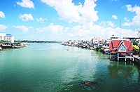
Tapi River, Thailand
Encyclopedia
Southern Thailand
Southern Thailand is a distinct region of Thailand, connected with the Central region by the narrow Kra Isthmus.-Geography:Southern Thailand is located on the Malay Peninsula, with an area around 70,713 km², bounded to the north by Kra Isthmus as the narrowest part of the peninsula. The...
. The river originates at the Khao Luang
Khao Luang
Khao Luang is the tallest mountain in southern Thailand. It is located in Nakhon Sri Thammarat province.-Geography:The Khao Luang mountain is the highest summit of a massif of several hills with steep slopes...
, and has a wide estuary
Estuary
An estuary is a partly enclosed coastal body of water with one or more rivers or streams flowing into it, and with a free connection to the open sea....
into the Gulf of Thailand
Gulf of Thailand
The Gulf of Thailand , also known in to Malays as Teluk Siam literally meant Gulf of Siam, is a shallow arm of the South China Sea.-Geography:...
at Bandon Bay
Bandon Bay
Bandon Bay is a bay in the Gulf of Thailand in the Surat Thani Province, extending from the Sui cape in Chaiya district in the northwest to the Kanchanadit district to the east. The total coastline is about 100 km. The bay is dominated by the estuary of the rivers Tapi and Phum Duang...
near the town of Surat Thani
Surat Thani
Surat Thani is a city in Amphoe Mueang Surat Thani, Surat Thani Province, southern Thailand. It is the capital of the province Surat Thani. The city has a population of 128,179 , and an area of 68.97 square kilometers. The city's population density is 1,858.47 inhabitants per km².Suran Thani is...
. It has a length of 230 km.
The river drains an area of 5460 km² and in 1997 had an annual discharge of 135.4 m³/s or 4.3 km³ per year. The Phum Duang River
Phum Duang River
The Phum Duang River is a river in Surat Thani Province, Southern Thailand, the main tributary of the Tapi River....
(or Khiri Rat River), which drains another 6,125 km² west of the Tapi watershed, joins the estuary 15 km west of Surat Thani in Amphoe Phunphin.
The river was named in August 1915 after the river Tapi
Tapti River
The Tapi River ancient original name Tapi River , is a river in central India. It is one of the major rivers of peninsular India with a length of around 724 km...
in India, shortly after the town of Surat Thani was named after the town Surat
Surat
Surat , also known as Suryapur, is the commercial capital city of the Indian state of Gujarat. Surat is India's Eighth most populous city and Ninth-most populous urban agglomeration. It is also administrative capital of Surat district and one of the fastest growing cities in India. The city proper...
.
The island of Ko Lamphu
Ko Lamphu
'Ko Lamphu' is a small island in the Tapi River, Thailand. This island is located about 9 km from the river mouth, near the town center of Surat Thani. It is connected by bridge to the city at the Pillar Shrine....
(เกาะลำพู) is located in the Tapi River, about 9 km from its mouth, right by the Surat Thani town center.
In 1975 an area of 29.6 km² of swamp land on the east bank of the river in the district Khian Sa
Amphoe Khian Sa
Khian Sa is a district in Surat Thani Province, Thailand.Neighboring districts are Khiri Rat Nikhom, Phunphin, Ban Na Doem, Ban Na San, Wiang Sa, Phrasaeng and Phanom...
was declared the Nong Thung Thong
Nong Thung Thong
Nong Thung Thong is a swamp on the east bank of the Tapi River in Khian Sa district, Surat Thani Province, southern Thailand.The area, together with the Nong Tung Ka on the west bank of the river, forms a complex of grassland and swamps along the river...
non-hunting area.