
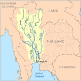
Sakae Krang River
Encyclopedia
The Sakae Krang River is a tributary of the Chao Phraya River
. It originates in Mae Wong National Park
, Kamphaeng Phet Province
. It is 225 km long, with most of its length in Uthai Thani Province
. It tributes the Chao Phraya River
in Uthai Thani city
around Wat Tha Sung (Tha Sung temple).
According to the Tourism Authority of Thailand, the people of Uthai Thani use the Sakae Krang River to grow pandanus
and to raise fish in floating baskets, which is the primary occupation of the Uthai Thani people.
, Wang Ma
, Wong
, Pho
and Tak Daet
Rivers.
. The total land area drained by the Sakae Krang River is 5,191 square kilometers.
Chao Phraya River
The Chao Phraya is a major river in Thailand, with its low alluvial plain forming the centre of the country. It runs through Bangkok, the capital city, and then empties into the Gulf of Thailand.-Etymology:...
. It originates in Mae Wong National Park
Mae Wong National Park
Mae Wong National Park is a national park in Thailand.-Description:Mae Wong National Park is situated in the Thanon Thong Chai Mountain Range....
, Kamphaeng Phet Province
Kamphaeng Phet Province
Kamphaeng Phet is one of the provinces of Thailand, located in the north of the country. Neighboring provinces are Sukhothai, Phitsanulok, Phichit, Nakhon Sawan and Tak.- Etymology :...
. It is 225 km long, with most of its length in Uthai Thani Province
Uthai Thani Province
Uthai Thani is one of the provinces of Thailand. Neighboring provinces are Nakhon Sawan, Chai Nat, Suphan Buri, Kanchanaburi and Tak.-Geography:...
. It tributes the Chao Phraya River
Chao Phraya River
The Chao Phraya is a major river in Thailand, with its low alluvial plain forming the centre of the country. It runs through Bangkok, the capital city, and then empties into the Gulf of Thailand.-Etymology:...
in Uthai Thani city
Uthai Thani
Uthai Thani is a town in Thailand, capital of the Uthai Thani province, in the Lower North of the country. It covers the whole tambon Uthai Mai of Mueang Uthai Thani district. The town is situated on the right bank of the Sakae Krang River, a few kilometers upstream from where it flows into the...
around Wat Tha Sung (Tha Sung temple).
According to the Tourism Authority of Thailand, the people of Uthai Thani use the Sakae Krang River to grow pandanus
Pandanus
Pandanus is a genus of monocots with about 600 known species. They are numerous palmlike dioecious trees and shrubs native of the Old World tropics and subtropics. They are classified in the order Pandanales, family Pandanaceae.-Overview:...
and to raise fish in floating baskets, which is the primary occupation of the Uthai Thani people.
Tributaries
Tributaries of the Sakae Krang River include the Thap SalaoThap Salao River
The Thap Salao River is a river of Thailand. It is a tributary of the Sakae Krang River, part of the Chao Phraya River basin....
, Wang Ma
Wang Ma River
The Wang Ma River is a river of Thailand. It is a tributary of the Sakae Krang River, part of the Chao Phraya River basin.-See also:*Tributaries of the Chao Phraya River...
, Wong
Wong River
The Wong River is a river of Thailand. It is a tributary of the Sakae Krang River, part of the Chao Phraya River basin.-See also:*Tributaries of the Chao Phraya River...
, Pho
Pho River
The Pho River is a river of Thailand. It is a tributary of the Sakae Krang River, part of the Chao Phraya River basin.-See also:*Tributaries of the Chao Phraya River...
and Tak Daet
Tak Daet River
The Tak Daet River is a river of Thailand. It is a tributary of the Sakae Krang River, part of the Chao Phraya River basin.-See also:*Tributaries of the Chao Phraya River...
Rivers.
Sakae Krang Basin
The Sakae Krang is part of the Chao Phraya WatershedChao Phraya River
The Chao Phraya is a major river in Thailand, with its low alluvial plain forming the centre of the country. It runs through Bangkok, the capital city, and then empties into the Gulf of Thailand.-Etymology:...
. The total land area drained by the Sakae Krang River is 5,191 square kilometers.