
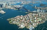
Port Jackson
Encyclopedia

Harbor
A harbor or harbour , or haven, is a place where ships, boats, and barges can seek shelter from stormy weather, or else are stored for future use. Harbors can be natural or artificial...
of Sydney
Sydney
Sydney is the most populous city in Australia and the state capital of New South Wales. Sydney is located on Australia's south-east coast of the Tasman Sea. As of June 2010, the greater metropolitan area had an approximate population of 4.6 million people...
, Australia
Australia
Australia , officially the Commonwealth of Australia, is a country in the Southern Hemisphere comprising the mainland of the Australian continent, the island of Tasmania, and numerous smaller islands in the Indian and Pacific Oceans. It is the world's sixth-largest country by total area...
. It is known for its beauty, and in particular, as the location of the Sydney Opera House and Sydney Harbour Bridge. The location of the first European settlement in Australia, the harbour has continued to play a key role in the history and development of Sydney.
It is used as the location of Sydney New Year's Eve and the starting point of the Sydney to Hobart yacht race
Sydney to Hobart Yacht Race
The Sydney to Hobart Yacht Race is hosted by the Cruising Yacht Club of Australia, starting in Sydney, Australia on Boxing Day and finishing in Hobart. The race distance is approximately...
.
History
_v2.jpg)
Cammeraygal
The Cammeraygal are an Indigenous Australian people that inhabited the Lower North Shore area of the present-day North Sydney Council in Sydney, Australia....
, Eora
Eora
The Eora are the Aboriginal people of the Sydney area, south to the Georges River, north to the Hawkesbury River, and west to Parramatta. The indigenous people used this word to describe where they came from to the British. "Eora" was then used by the British to refer to those Aboriginal people...
and Wangal peoples. The Gadigal people are said to have occupied the land stretching along the south side of Port Jackson from what is now South Head, in an arc west through to Petersham
Petersham, New South Wales
Petersham is a suburb in the Inner West of Sydney, in the state of New South Wales, Australia. Petersham is located 6 kilometres south-west of the Sydney central business district, in the local government area of Marrickville Council...
. The Cammeraygal lived on the northern side of the harbour. The area along the southern banks of the Parramatta River
Parramatta River
The Parramatta River is a waterway in Sydney, New South Wales, Australia. The Parramatta River is the main tributary of Sydney Harbour, a branch of Port Jackson, along with the smaller Lane Cove and Duck Rivers....
, west of Petersham to Rose Hill
Rose Hill, New South Wales
Founded on the 2 November 1788, Rose Hill in New South Wales was the first inland colonial settlement, established by Governor Phillip. On the King's Birthday in 1791 it was renamed to become the town of Parramatta, after the indigenous Aborigines of the region, the Burramatta people, a clan of...
, was reported to belong to the Wanegal. The Eora people lived on the southern side of the harbour, close to where the First Fleet settled.
The first recorded European discovery of Sydney Harbour, was by Lt James Cook
James Cook
Captain James Cook, FRS, RN was a British explorer, navigator and cartographer who ultimately rose to the rank of captain in the Royal Navy...
in 1770 - Cook named the inlet after Sir George Jackson, (one of the Lord Commissioners of the British Admiralty
Admiralty
The Admiralty was formerly the authority in the Kingdom of England, and later in the United Kingdom, responsible for the command of the Royal Navy...
, and Judge Advocate of the Fleet
Judge Advocate of the Fleet
In the United Kingdom, the Judge Advocate of Her Majesty's Fleet was a civilian judge who was responsible for the supervision and superintendence of the court martial system in the Royal Navy...
). His ship's log notation states "at noon we where...about 2 or 3 miles from the land and abrest of a bay or harbour within there appeared to be a safe anchorage which I called Port Jackson."
Eighteen years later, on 21 January 1788, after arriving at Botany Bay
Botany Bay
Botany Bay is a bay in Sydney, New South Wales, a few kilometres south of the Sydney central business district. The Cooks River and the Georges River are the two major tributaries that flow into the bay...
, Governor Arthur Phillip
Arthur Phillip
Admiral Arthur Phillip RN was a British admiral and colonial administrator. Phillip was appointed Governor of New South Wales, the first European colony on the Australian continent, and was the founder of the settlement which is now the city of Sydney.-Early life and naval career:Arthur Phillip...
took a longboat
Longboat
In the days of sailing ships, a vessel would carry several ship's boats for various uses. One would be a longboat, an open boat to be rowed by eight or ten oarsmen, two per thwart...
and two cutters up the coast to examine Cook's Port Jackson. Phillip first stayed over night at Camp Cove
Watsons Bay, New South Wales
Watsons Bay is a harbourside, eastern suburb of Sydney, in the state of New South Wales, Australia. Watsons Bay is located 11 km north-east of the Sydney central business district, in the local government area of the Municipality of Woollahra....
, then moved down the harbour, landing at Sydney Cove and then Manly Cove before returning to Botany Bay on the afternoon of the 24th.
Phillip returned to Sydney Cove in H.M. Armed Tender Supply on 26 January 1788, where he established the first colony
Colony
In politics and history, a colony is a territory under the immediate political control of a state. For colonies in antiquity, city-states would often found their own colonies. Some colonies were historically countries, while others were territories without definite statehood from their inception....
in Australia, later to become the city of Sydney.
In his first dispatch from the colony back to England, Governor Phillip noted that "...we had the satisfaction of finding the finest harbour in the world, in which a thousand sail of the line may ride in the most perfect security..."
Watsons Bay, New South Wales
Watsons Bay is a harbourside, eastern suburb of Sydney, in the state of New South Wales, Australia. Watsons Bay is located 11 km north-east of the Sydney central business district, in the local government area of the Municipality of Woollahra....
to Georges Head, Mosman
Mosman, New South Wales
Mosman is a suburb on the Lower North Shore of Sydney, in the state of New South Wales, Australia. Mosman is located 8 kilometres north-east of the Sydney central business district and is the administrative centre for the local government area of the Municipality of Mosman.-Localities:In February...
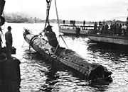
, which is on the other side of the harbour. On the night of 31 May 1942, three Japanese midget submarines
Attack on Sydney Harbour
In late May and early June 1942, during World War II, submarines belonging to the Imperial Japanese Navy made a series of attacks on the cities of Sydney and Newcastle in New South Wales, Australia...
attempted to enter the harbour, one of which became entangled in the western end of the boom net's central section. Unable to free their submarine, the crew detonated charges to destroy it, killing themselves in the process. The anti-submarine boom net was demolished soon after World War II
World War II
World War II, or the Second World War , was a global conflict lasting from 1939 to 1945, involving most of the world's nations—including all of the great powers—eventually forming two opposing military alliances: the Allies and the Axis...
, and all that remains are the foundations of the old boom net winch house, which can be viewed on Green (Laings) Point, Watsons Bay. Today, that Japanese midget submarine remains on static display at the Australian War Memorial
Australian War Memorial
The Australian War Memorial is Australia's national memorial to the members of all its armed forces and supporting organisations who have died or participated in the wars of the Commonwealth of Australia...
.
Fortifications
A number of former fortifications line Sydney HarbourSydney Harbour defences
Sydney Harbour was protected by coastal batteries and other fixed defences from the early 19th century until the 1960s. These defences were constructed to protect the Australian city of Sydney from attack by enemy warships and submarines....
, some of which are now heritage listed. The earliest date from the 1830s, and were designed to defend Sydney from seaborn attack or convict uprisings. There are four historical fortifications located between Taronga Zoo and Middle Head, Mosman
Mosman, New South Wales
Mosman is a suburb on the Lower North Shore of Sydney, in the state of New South Wales, Australia. Mosman is located 8 kilometres north-east of the Sydney central business district and is the administrative centre for the local government area of the Municipality of Mosman.-Localities:In February...
, they are: the Middle Head Fortifications
Middle Head Fortifications
The Middle Head Fortification is located at the end of Old Fort Road, Middle Head, Mosman, New South Wales. The fortifications at Middle Head formed part of Sydney Harbour's defences.-History:The fortifications were built between 1870 and 1911....
, the Georges Head Battery
Georges Head Battery
The Georges Head Battery is located on Georges Head, in the suburb of Mosman in Sydney, New South Wales, Australia. The Georges Head battery is one of three forts in the area that were built for the purpose of defending the outer harbour...
, the Lower Georges Heights Commanding Position
Lower Georges Heights Commanding Position
The Lower Georges Heights Commanding Position is located in the urban locality of Georges Heights, New South Wales in the suburb of Mosman, on the shores of Port Jackson, Sydney, Australia...
and a small fort located on Bradleys Head, known as the Bradleys Head Fortification Complex
Bradleys Head Fortification Complex
The Bradleys Head Fortification Complex is a small fort located on the northern side of Taronga Park Zoo that formed part of a total defence system for Sydney Harbour and recalls a period when the colony of New South Wales became increasingly aware of its isolation and wealth...
. The forts were built from sandstone
Sandstone
Sandstone is a sedimentary rock composed mainly of sand-sized minerals or rock grains.Most sandstone is composed of quartz and/or feldspar because these are the most common minerals in the Earth's crust. Like sand, sandstone may be any colour, but the most common colours are tan, brown, yellow,...
quarried on site and consist of various tunnels, underground rooms, open batteries and casemated batteries, shell rooms, gunpowder magazine
Gunpowder magazine
A gunpowder magazine is a magazine designed to store the explosive gunpowder in wooden barrels for safety. Gunpowder, until superseded, was a universal explosive used in the military and for civil engineering: both applications required storage magazines...
s, barracks and trenches.
Geography
Geologically, Port Jackson is a drowned river valley, or riaRia
A ria is a coastal inlet formed by the partial submergence of an unglaciated river valley. It is a drowned river valley that remains open to the sea. Typically, rias have a dendritic, treelike outline although they can be straight and without significant branches. This pattern is inherited from the...
. It is 19 km long with an area of 55 km². The estuary's volume at high tide is 562 million cubic metres. The perimeter of the estuary is 317 kilometres.
According to the Geographical Names Board of New South Wales, Port Jackson is "a harbour which comprises all the waters within an imaginary line joining North Head and South Head. Within this harbour lies North Harbour, Middle Harbour and Sydney Harbour." These three harbours extend from the single entrance (known as Sydney Heads
Sydney Heads
Sydney Heads , is the entrance to Port Jackson in Sydney, New South Wales, Australia.North Head and Quarantine Head are to the north, South Head and Dunbar Head are to the south. Middle Head, Georges Head and Chowder Head are to the west and within the bay...
(North and South Heads)). North Harbour is the shortest, and is really just a large bay extending to Manly
Manly, New South Wales
Manly is a suburb of northern Sydney, in the state of New South Wales, Australia. Manly is located 17 kilometres north-east of the Sydney central business district and is the administrative centre of the local government area of Manly Council, in the Northern Beaches region.-History:Manly was named...
. Middle Harbour extends to the north-west. It is bridged at The Spit
The Spit, New South Wales
The Spit is an urban locality in the suburb of Mosman in Sydney, New South Wales, Australia. The Spit is located in the local government area of the Municipality of Mosman and is part of the Lower North Shore.-Landmarks:...
and Roseville
Roseville, New South Wales
Roseville is a suburb on the Upper North Shore of Sydney in the state of New South Wales, Australia. Roseville is located north-west of the Sydney central business district and sits across the local government areas of Ku-ring-gai and Willoughby...
. Its headwaters lie in Garigal National Park
Garigal National Park
Garigal National Park is a national park in New South Wales , 20 km north of central Sydney. The park is somewhat disjointed but covers the following areas:...
. The longest arm, Sydney Harbour, extends west as far as Balmain, where it is fed by the estuaries of the Parramatta
Parramatta River
The Parramatta River is a waterway in Sydney, New South Wales, Australia. The Parramatta River is the main tributary of Sydney Harbour, a branch of Port Jackson, along with the smaller Lane Cove and Duck Rivers....
and Lane Cove
Lane Cove River
The Lane Cove River is a tributary of the Parramatta River, Sydney, Australia. Its lower reaches form an arm of Sydney Harbour.-Description:...
rivers. Port Jackson is bridged by the Sydney Harbour Bridge and the ANZAC Bridge
ANZAC Bridge
The ANZAC Bridge or Anzac Bridge , replacing the earlier Glebe Island Bridge, is a large cable-stayed bridge spanning Johnstons Bay between Pyrmont and Glebe Island in proximity to the central business district of Sydney, Australia...
(formerly known as the Glebe Island Bridge). A tunnel, the Sydney Harbour Tunnel
Sydney Harbour Tunnel
The Sydney Harbour Tunnel is a twin-tube road tunnel in Sydney, Australia. The tunnel was completed and opened to traffic in August 1992 to provide a second vehicular crossing of Sydney Harbour to alleviate congestion on the Sydney Harbour Bridge....
passes underneath the Harbour, to the east of the bridge, and in 2005 it was proposed that a third harbour crossing, this time a railway line, be constructed to the west of the bridge. The harbour is heavily embayed. The bays on the south side tend to be wide and rounded, whereas those on the north side are generally narrow inlets. Sydney's major central business district
Central business district
A central business district is the commercial and often geographic heart of a city. In North America this part of a city is commonly referred to as "downtown" or "city center"...
begins at Circular Quay, a small bay on the south side that has, over time, had its semicircle reclaimed by land to the point where it is a rectangular quay. The northern side of the harbour is mainly used for residential purposes.
The waterways of Port Jackson are managed by the New South Wales Maritime Authority.
Islands
There are several islands within the harbour, including Shark Island, Clark IslandClark Island (New South Wales)
Clark Island is an island in Sydney Harbour, Australia. It lies offshore of the Sydney suburb of Darling Point, in the eastern section of the harbour between the Harbour Bridge and the harbour entrance. It is 0.9 hectares in area....
, Fort Denison, Goat Island
Goat Island (Port Jackson)
Goat Island is a rocky island in Sydney Harbour, in New South Wales, Australia. The island is some 400 m by 200 m in size and is located north-west of the Sydney central business district....
, Cockatoo Island, Spectacle Island, Snapper Island and Rodd Island. Some other former islands, including Bennelong Island
Bennelong Point, New South Wales
Bennelong Point is the location of the Sydney Opera House in Sydney, Australia . It was called Tubowghule by the indigenous Eora peoples....
, Garden Island
Garden Island, New South Wales
Garden Island is an inner-city locality of Sydney, in the state of New South Wales, Australia. It is located to the north-east of the Sydney central business district, north of the suburb of Potts Point....
and Berry Island
Berry Island, New South Wales
Berry Island is an locality of Sydney, in the state of New South Wales, Australia. It was originally one of Sydney's Harbour Islands, but it is now connected to the mainland by a constructed isthmus....
, have subsequently been linked to the shore by land reclamation.
Tributaries and waterways
- Tank StreamTank StreamThe Tank Stream is a fresh water course which empties into Sydney Cove in New South Wales, Australia. Today it is little more than a storm water drain, but originally it was the fresh water supply for the fledgling colony of New South Wales in the late 18th century...
is a fresh water course which empties into Sydney CoveSydney CoveSydney Cove is a small bay on the southern shore of Port Jackson , on the coast of the state of New South Wales, Australia....
. Today it is little more than a storm water drain but originally it was the fresh water supply for the fledgling colony of New South Wales in the late 18th century. It originated from a swamp to the west of present day Hyde ParkHyde Park, SydneyHyde Park is a large park in Sydney, New South Wales, Australia. Hyde Park is on the eastern side of the Sydney central business district. It is the southernmost of a chain of parkland that extends north to the shore of Port Jackson . It is approximately rectangular in shape, being squared at the...
and at high tide entered Sydney Cove at the intersection of BridgeBridge Street, SydneyBridge Street is a street in the CBD of Sydney, Australia. It runs east-west between George Street and Macquarie Street. It is in the Local Government Area of the City of Sydney and the postcode is 2000. The street is 500 metres long...
and Pitt StreetPitt Street, SydneyPitt Street is a major street in central Sydney, New South Wales, Australia. The street runs through the entire city centre from Circular Quay in the north to Waterloo, although today's street is in two disjointed sections after a substantial stretch of it was removed to make way for Sydney's...
s.
- Middle HarbourMiddle HarbourMiddle Harbour is the northern arm of Port Jackson in Sydney, Australia.Middle Harbour extends about to the northwest, from where it joins the main harbour near the Heads. Its shore is nearly everywhere rugged, barren and forested and for this reason Middle Harbour was almost entirely neglected...
is the northern arm of Sydney Harbour. It begins as a small creek (Middle Harbour Creek) at St Ives Chase. It joins Port Jackson between the two headlands, Middle Head and Grotto Point Reserve, adjacent to the Sydney Heads.
- Iron Cove CreekIron Cove CreekIron Cove Creek was a creek in Sydney, in the state of New South Wales, Australia. It is located in the inner-western suburbs of Croydon, Ashfield, Haberfield and Five Dock...
is located in the inner-westernInner West (Sydney)The Inner West is a general term which is used to describe the metropolitan area directly to the west of the Sydney central business district, New South Wales, Australia...
suburbs of CroydonCroydon, New South WalesCroydon is an affluent suburb in the inner-west of Sydney, in the state of New South Wales, Australia. Croydon is located 11 kilometres west of the Sydney central business district. Croydon is split between the two local government areas of Burwood Council and the Municipality of Ashfield.The...
, AshfieldAshfield, New South WalesAshfield is a suburb in the inner-west of Sydney, in the state of New South Wales, Australia. Ashfield is about 9 kilometres south-west of the Sydney central business district and is the administrative centre for the local government area of the Municipality of Ashfield.The official name for the...
, HaberfieldHaberfield, New South WalesHaberfield is a suburb in the inner-west of Sydney, in the state of New South Wales, Australia. Haberfield is located 9 kilometres west of the Sydney central business district in the local government area of the Municipality of Ashfield....
and Five DockFive Dock, New South WalesFive Dock is a suburb in the inner-west of Sydney, in the state of New South Wales, Australia. Five Dock is located 10 kilometres west of the Sydney central business district, in the Local Government Area of the City of Canada Bay.-Location:...
. Iron Cove Creek traverses mostly through residential areas and parkland, making a two kilometre journey from where it surfaces in Croydon to where it empties along with Hawthorne CanalHawthorne CanalThe Hawthorne Canal is a short canal that connects with Port Jackson, in Sydney, Australia. It was originally a natural waterway known as Long Cove Creek, that has been straightened and given artificial banks. It borders on Summer Hill, Lewisham, Leichhardt and Haberfield...
into Iron Cove, which is a bay of the Parramatta River.
- Duck RiverDuck River (New South Wales)The Duck River is a watercourse located in Sydney, New South Wales, Australia. The Duck River flows in a generally north then east-north-east direction for about 11.5 km from where it rises from a drain in the suburb of Birrong to where it joins the Parramatta River at Silverwater. It was...
a tributary of the Parramatta River entering at Silverwater is fed by two creeks, Duck CreekDuck Creek (Clyde, New South Wales)Duck Creek is located in western Sydney, New South Wales, Australia. It flows through the suburbs of Granville and Clyde where it joins with A'Beckett Creek.-See also:*Duck River*Parramatta River*Port Jackson...
and A'Beckett CreekA'Beckett CreekA'Beckett Creek is located in western Sydney, New South Wales, Australia. It flows into the Duck River at Silverwater. Duck Creek joins A'Beckett Creek at Clyde....
. It drains localties around the suburbs of Silverwater and AuburnAuburn, New South WalesAuburn is a suburb in western Sydney, in the state of New South Wales Australia. Auburn is located 19 kilometres west of the Sydney central business district and is the administrative centre of the local government area of Auburn Council.-History:...
and was named in light of the large population of ducks which inhabit the stream.
- Parramatta RiverParramatta RiverThe Parramatta River is a waterway in Sydney, New South Wales, Australia. The Parramatta River is the main tributary of Sydney Harbour, a branch of Port Jackson, along with the smaller Lane Cove and Duck Rivers....
is the main tributary of Sydney Harbour, a branch of Port Jackson. The river begins at confluence of Toongabbie CreekOld Toongabbie, New South WalesOld Toongabbie is a suburb of Sydney, in the state of New South Wales, Australia. Old Toongabbie is located 29 kilometres west of the Sydney central business district in the local government area of the City of Parramatta and is part of the Greater Western Sydney region.- History:Toongabbie is...
and Darling Mills Creek west of ParramattaParramatta, New South WalesParramatta is a suburb of Sydney, in the state of New South Wales, Australia. It is located in Greater Western Sydney west of the Sydney central business district on the banks of the Parramatta River. Parramatta is the administrative seat of the Local Government Area of the City of Parramatta...
and travels in an easterly direction to a line between Greenwich Point, GreenwichGreenwich, New South WalesGreenwich is a suburb on the lower North Shore of Sydney, in the state of New South Wales, Australia. Greenwich is located 7 kilometres north-west of the Sydney central business district, in the local government area of the Municipality of Lane Cove.The suburb occupies a peninsula on the northern...
, and Robinsons Point, BirchgroveBirchgrove, New South WalesBirchgrove is a suburb in the inner-west of Sydney, in the state of New South Wales, Australia. Birchgrove is located 5 kilometres west of the Sydney central business district, in the local government area of the Municipality of Leichhardt....
. Here it flows into Port Jackson, still about 21 km from the ocean.
- Lane Cove RiverLane Cove RiverThe Lane Cove River is a tributary of the Parramatta River, Sydney, Australia. Its lower reaches form an arm of Sydney Harbour.-Description:...
is a tributary of the Parramatta River, its lower reaches form an arm of Sydney Harbour. The lower reaches of the Lane Cove River are tidal and merge into Sydney Harbour at Greenwich and Hunters HillHunters Hill, New South WalesHunters Hill is a suburb in Sydney, in the state of New South Wales, Australia. Hunters Hill is located 9 kilometres north-west of the Sydney central business district and is the administrative centre for the local government area of the Municipality of Hunter's Hill.Hunters Hill is situated on a...
.
- Johnstons Creek is located in the inner-western suburbs of Glebe, Annandale, Forest Lodge and Stanmore. It rises in Stanmore and flows in a generally northward direction towards Rozelle Bay. The creek passes beneath the stands of Harold Park PacewayHarold Park PacewayHarold Park Paceway was a harness racing track in Glebe, New South Wales. It was a half-mile track but was just 739m in circumference until some changes in recent years...
prior to emptying into Rozelle Bay at Bicentennial Park Glebe. Orphan School CreekOrphan School CreekOrphan School Creek is a storm drain located in inner Sydney, New South Wales. It is a tributary of Johnstons Creek which flows into Rozelle Bay.-External links:*-See also:*Whites Creek*Johnstons Creek...
is a tributary of Johnstons Creek.
Maritime transport
Sydney FerriesSydney Ferries
Sydney Ferries is an agency of the New South Wales Government Department of Transport, providing ferry services on Sydney Harbour and the Parramatta River in Sydney, Australia....
is an agency of the New South Wales Department of Transport, providing ferry services on Sydney Harbour and the Parramatta River in Sydney, Australia. Most ferry wharves, aside from those concentrated around the Central Business District, lie on the northern banks of the harbour, or on the southern bank, east of the Harbour Bridge. There is a lesser concentration of ferry wharves in the western areas of the harbour.
A service runs to Parramatta, along the Parramatta River, which is serviced by the RiverCat vessels, a large catamaran type ferry.
In addition to the state owned ferry service, private ferry operators run a fast commuter service between Manly and the city during peak times. Fast services on this route are now offered by private operators, following the Government decision in December 2009 to cease the premium service operated by Sydney Ferries.
Finally, a small number of water taxi and water limousine operators are active on the harbour, offering transport to individuals and groups who do not wish to travel by ferry. These water taxis are not restricted by timetables or specific routes, and can also provide a service to or from private wharfs and houses on the waterfront.
Derivative unit of measure
A Sydharb is a unit of volume used in Australia for water. One sydharb (or sydarb), also called a Sydney Harbour, is the amount of water in the Sydney Harbour (Port Jackson): approximately 500 GL.External links
- NSW Maritime Authority
- Maps maintained by the New South Wales Maritime Authority, which legally is the owner of the harbour bed:
- Sydney Harbour Federation Trust Established by the Australian Government to plan for the future of former Defence and other special Commonwealth Lands around Sydney Harbour.
- Geographic Names Board of New South Wales reference to Port Jackson
- A Living Harbour A history of Sydney Harbour from ABC Radio National