

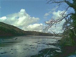
River Fal
Encyclopedia
Cornwall
Cornwall is a unitary authority and ceremonial county of England, within the United Kingdom. It is bordered to the north and west by the Celtic Sea, to the south by the English Channel, and to the east by the county of Devon, over the River Tamar. Cornwall has a population of , and covers an area of...
, United Kingdom
United Kingdom
The United Kingdom of Great Britain and Northern IrelandIn the United Kingdom and Dependencies, other languages have been officially recognised as legitimate autochthonous languages under the European Charter for Regional or Minority Languages...
, rising on the Goss Moor (between St. Columb and St Austell
St Austell
St Austell is a civil parish and a major town in Cornwall, England, United Kingdom. It is situated on the south coast approximately ten miles south of Bodmin and 30 miles west of the border with Devon at Saltash...
) and reaching the English Channel
English Channel
The English Channel , often referred to simply as the Channel, is an arm of the Atlantic Ocean that separates southern England from northern France, and joins the North Sea to the Atlantic. It is about long and varies in width from at its widest to in the Strait of Dover...
at Falmouth
Falmouth, Cornwall
Falmouth is a town, civil parish and port on the River Fal on the south coast of Cornwall, England, United Kingdom. It has a total resident population of 21,635.Falmouth is the terminus of the A39, which begins some 200 miles away in Bath, Somerset....
. On or near the banks of the Fal are the castles of Pendennis
Pendennis Castle
Pendennis Castle is a Henrician castle, also known as one of Henry VIII's Device Forts, in the English county of Cornwall. It was built in 1539 for King Henry VIII to guard the entrance to the River Fal on its west bank, near Falmouth. St Mawes Castle is its opposite number on the east bank and...
and St Mawes
St Mawes Castle
St Mawes Castle and its larger sister castle, Pendennis, were built as part of a defensive chain of fortresses by Henry VIII to protect the south coast of Cornwall, England, United Kingdom...
as well as Trelissick Garden
Trelissick Garden
Trelissick Garden is a garden in the ownership of the National Trust and situated in Feock, Cornwall, near Truro, Cornwall, United Kingdom.-The Trust:...
. The River Fal separates the Roseland
Roseland, Cornwall
The Roseland Peninsula, or just Roseland, is a district of west Cornwall in the United Kingdom. Roseland is located in the south of the county and contains the town of St Mawes and villages such as St Just and Gerrans...
peninsula from the rest of Cornwall. Like most of its kind on the south coast of Cornwall and Devon, the Fal estuary is a classic ria
Ria
A ria is a coastal inlet formed by the partial submergence of an unglaciated river valley. It is a drowned river valley that remains open to the sea. Typically, rias have a dendritic, treelike outline although they can be straight and without significant branches. This pattern is inherited from the...
, or drowned river valley.
Toponymy
The origin and meaning of the name of the river are unknown. The earliest occurrences of the name are in documents of 969 and 1049 AD. Falmouth, a town which was known by another name until the 17th century, is named after the River Fal.History
The word Fal in CornishCornish language
Cornish is a Brythonic Celtic language and a recognised minority language of the United Kingdom. Along with Welsh and Breton, it is directly descended from the ancient British language spoken throughout much of Britain before the English language came to dominate...
may refer to a prince, or on the other hand to a spade or shovel.
The river mouth and Falmouth harbour served as an anchorage in the immediate years after the Second World War for scores of laid-up Royal Navy
Royal Navy
The Royal Navy is the naval warfare service branch of the British Armed Forces. Founded in the 16th century, it is the oldest service branch and is known as the Senior Service...
vessels (including battleships, carriers, and cruisers) awaiting sale for scrap. Its size and depth of water made it ideal for this use.
Geography and Hydrology
The catchment of the Fal is predominantly Devonian slates, shales and grits, with Granite in the upper reaches. Land use is mainly agricultural with some woodland.Tributaries of the River Fal include the River Truro
River Truro
The River Truro is a river in the city of Truro in Cornwall, England, UK. It is the product of the convergence of the two rivers named Kenwyn and Allen which run under the city: the River Truro flows into the River Fal, estuarial waters where wildlife is abundant, and then out into the Carrick Roads...
, River Kennal, River Penryn and River Carnon. Several tidal creeks discharge into the River Fal including Mylor Creek
Mylor Creek
Mylor Creek is a tidal ria in south Cornwall, United Kingdom. It is a tributary of Carrick Roads, the estuary of the River Fal and is situated approximately six miles south of Truro and two miles north of Falmouth....
, Pill Creek, Penpol Creek and Restronguet Creek
Restronguet Creek
Restronguet Creek is a tidal ria in south Cornwall, United Kingdom. It is a tributary of Carrick Roads, the estuary of the River Fal, and is situated approximately four miles south of Truro and three miles north of Falmouth....
.
The river is crossed by the historic and scenic King Harry Ferry
King Harry Ferry
The King Harry Ferry Bridge is a vehicular chain ferry which crosses the Carrick Roads reach of the estuary of the River Fal in the United Kingdom county of Cornwall. The ferry crosses between the villages of Feock and Philleigh, roughly half way between the city of Truro, the lowest bridging point...
, a vehicular chain ferry
Cable ferry
A cable ferry is guided and in many cases propelled across a river or other larger body of water by cables connected to both shores. They are also called chain ferries, floating bridges, or punts....
that links the villages of Feock
Feock, Cornwall
Feock is a coastal civil parish and village in Cornwall, United Kingdom. It is situated approximately 5 miles south of Truro at the head of Carrick Roads on the River Fal. To the south, the parish is bounded by Restronguet Creek and to the east by Carrick Roads and the River Fal...
and Philleigh
Philleigh
Philleigh is a civil parish and village in Cornwall, England, in the United Kingdom, one of the four in the Roseland Peninsula.-History:The Manor of Eglosrose is mentioned in the Domesday Book and the remainder of the parish was in the episcopal Manor of Tregear. The parish church is dedicated to...
approximately equidistant between Truro and Falmouth.
The River Fal suffered a severe, high profile pollution accident in February 1992, when a nearby tin mine was flooded. The river turned red and an extensive cleaning-up operation was needed to decontaminate the water. http://www.ifimages.com/public/image/1077078/view.html
During times of reduced global trade ships are mothballed in the estuary of the River Fal.
Wildlife and conservation
Five Sites of Special Scientific Interest (SSSI) have been designated along the River Fal. The river rises on Goss Moor which is both a National Nature ReserveNational Nature Reserve
For details of National nature reserves in the United Kingdom see:*National Nature Reserves in England*National Nature Reserves in Northern Ireland*National Nature Reserves in Scotland*National Nature Reserves in Wales...
and part of a SSSI. The wetland habitats and western dry heath communites were formed, since the Bronze Age
Bronze Age
The Bronze Age is a period characterized by the use of copper and its alloy bronze as the chief hard materials in the manufacture of some implements and weapons. Chronologically, it stands between the Stone Age and Iron Age...
, by the mining of the alluvial tin deposits. South Terras Mine SSSI is also a Geological Conservation Review
Geological Conservation Review
The Geological Conservation Review is produced by the UK's Joint Nature Conservation Committee and is designed to identify those sites of national and international importance needed to show all the key scientific elements of the geological and geomorphological features of Britain...
(GCR) site of national importance and was once a commercial uranium
Uranium
Uranium is a silvery-white metallic chemical element in the actinide series of the periodic table, with atomic number 92. It is assigned the chemical symbol U. A uranium atom has 92 protons and 92 electrons, of which 6 are valence electrons...
mine. The Crowhill Valley SSSI between Grampound
Grampound
Grampound is a village in Cornwall, England, United Kingdom. It is situated on the A390 road six miles west of St Austell.Grampound with Creed is the civil parish of which the village of Grampound and the village of Creed are the main settlements...
and St Stephen
St Stephen-in-Brannel
St Stephen-in-Brannel is a civil parish and village in central Cornwall, United Kingdom. St Stephen village is four miles west of St Austell on the southern edge of Cornwall's china clay district.In medieval times the parish lay within the royal manor of Brannel...
is an ancient woodland
Ancient woodland
Ancient woodland is a term used in the United Kingdom to refer specifically to woodland that has existed continuously since 1600 or before in England and Wales . Before those dates, planting of new woodland was uncommon, so a wood present in 1600 was likely to have developed naturally...
dominated by sessile oak
Sessile Oak
Quercus petraea , the Sessile Oak, also known as the Durmast Oak, is a species of oak native to most of Europe, and into Anatolia.-Description:...
on the slopes, and of willow
Willow
Willows, sallows, and osiers form the genus Salix, around 400 species of deciduous trees and shrubs, found primarily on moist soils in cold and temperate regions of the Northern Hemisphere...
and alder
Alder
Alder is the common name of a genus of flowering plants belonging to the birch family . The genus comprises about 30 species of monoecious trees and shrubs, few reaching large size, distributed throughout the North Temperate Zone and in the Americas along the Andes southwards to...
carr
Carr (topography)
A carr is a type of waterlogged, wooded terrain that, typically, represents a succession stage between the original reedy swamp and the eventual formation of forest in a sub-maritime climate....
on the floodplain which has a rich ground flora. The species list includes many ancient woodland indicators including lichens such as Parmelia endochlora. The Upper Fal Estuary and Woods SSSI is mostly within the tidal area of the river between Tregony
Tregony
Tregony is a civil parish and village in Cornwall, United Kingdom. It lies on the River Fal. In the village there is a post office, shop, and two churches. Tregony has bus links to the nearest town, which is Truro. The village is made up from two parishes namely, Tregony and Cuby...
and Turnaware Point and includes mudflats, salt marsh
Salt marsh
A salt marsh is an environment in the upper coastal intertidal zone between land and salt water or brackish water, it is dominated by dense stands of halophytic plants such as herbs, grasses, or low shrubs. These plants are terrestrial in origin and are essential to the stability of the salt marsh...
and ancient woodland. The mudflats support nationally important numbers of Black-tailed Godwit
Black-tailed Godwit
The Black-tailed Godwit, Limosa limosa, is a large, long-legged, long-billed shorebird first described by Carolus Linnaeus in 1758. It is a member of the Limosa genus, the godwits...
as well as large populations of wintering waders and wildfowl such as Curlew
Curlew
The curlews , genus Numenius, are a group of eight species of birds, characterised by long, slender, downcurved bills and mottled brown plumage. They are one of the most ancient lineages of scolopacid waders, together with the godwits which look similar but have straight bills...
and Golden Plover
Golden Plover
There are three species of wading birds in the plover family called Golden Plover. They are* Eurasian Golden Plover, Pluvialis apricaria* Pacific Golden Plover, Pluvialis fulva* American Golden Plover, Pluvialis dominica...
. A series of transition zones occur from the salt marsh to scrub
Scrub
Scrub or Scrubber may refer to:* Scrub, low shrub and grass characteristic of scrubland* Scrubs , worn by medical staff* Scrubs , an American television program...
, where young trees attempt to grow despite the threat of the highest tides, to ancient woodland on the higher slopes. These zones and the estuary itself are important for otter
Otter
The Otters are twelve species of semi-aquatic mammals which feed on fish and shellfish, and also other invertebrates, amphibians, birds and small mammals....
. The lowest part of the Fal along with the Helford River
Helford River
The Helford River is a ria located in Cornwall, England, UK, and not a true river. It is fed by a number of small streams into its numerous creeks...
is designated as the Fal and Helford Special Area of Conservation
Special Area of Conservation
A Special Area of Conservation is defined in the European Union's Habitats Directive , also known as the Directive on the Conservation of Natural Habitats and of Wild Fauna and Flora...
under the Habitats Directive for the shallow bays and inlets, sandbanks and mudflats, and for its salt marshes. Part of the area is also designated as a SSSI (Lower Fal & Helford Intertidal) for the relatively undisturbed transitions from tidal mud through saltmarsh and scrub to woodland.
Towns and villages on the Fal
- FalmouthFalmouth, CornwallFalmouth is a town, civil parish and port on the River Fal on the south coast of Cornwall, England, United Kingdom. It has a total resident population of 21,635.Falmouth is the terminus of the A39, which begins some 200 miles away in Bath, Somerset....
- FeockFeock, CornwallFeock is a coastal civil parish and village in Cornwall, United Kingdom. It is situated approximately 5 miles south of Truro at the head of Carrick Roads on the River Fal. To the south, the parish is bounded by Restronguet Creek and to the east by Carrick Roads and the River Fal...
- FlushingFlushing, CornwallFlushing is a coastal village in Cornwall, United Kingdom. It is situated three miles south of Penryn and eleven miles south-east of Truro. It faces Falmouth across the Penryn river, an arm of the Carrick Roads...
- GrampoundGrampoundGrampound is a village in Cornwall, England, United Kingdom. It is situated on the A390 road six miles west of St Austell.Grampound with Creed is the civil parish of which the village of Grampound and the village of Creed are the main settlements...
- Mylor
- Old KeaOld KeaOld Kea is a hamlet in Cornwall, United Kingdom. It is situated on the west bank of the Truro River approximately two miles south of Truro....
- PenrynPenryn, CornwallPenryn is a civil parish and town in Cornwall, England, United Kingdom. It is situated on the Penryn River about one mile northwest of Falmouth...
- St ClementSt Clement, CornwallSt Clement is a civil parish and village in Cornwall, United Kingdom. It is situated southeast of Truro in the valley of the Tresillian River. There is a smaller village at Malpas in the south of the parish...
- St Just in RoselandSt Just in RoselandSt Just in Roseland is a civil parish and village in Cornwall, England, United Kingdom. The village is situated six miles south of Truro and two miles north of St Mawes....
- TregonyTregonyTregony is a civil parish and village in Cornwall, United Kingdom. It lies on the River Fal. In the village there is a post office, shop, and two churches. Tregony has bus links to the nearest town, which is Truro. The village is made up from two parishes namely, Tregony and Cuby...