

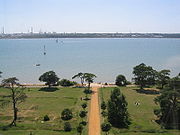
Southampton Water
Encyclopedia

Estuary
An estuary is a partly enclosed coastal body of water with one or more rivers or streams flowing into it, and with a free connection to the open sea....
north of the Solent
Solent
The Solent is a strait separating the Isle of Wight from the mainland of England.The Solent is a major shipping route for passengers, freight and military vessels. It is an important recreational area for water sports, particularly yachting, hosting the Cowes Week sailing event annually...
and the Isle of Wight
Isle of Wight
The Isle of Wight is a county and the largest island of England, located in the English Channel, on average about 2–4 miles off the south coast of the county of Hampshire, separated from the mainland by a strait called the Solent...
in England
England
England is a country that is part of the United Kingdom. It shares land borders with Scotland to the north and Wales to the west; the Irish Sea is to the north west, the Celtic Sea to the south west, with the North Sea to the east and the English Channel to the south separating it from continental...
. The city of Southampton
Southampton
Southampton is the largest city in the county of Hampshire on the south coast of England, and is situated south-west of London and north-west of Portsmouth. Southampton is a major port and the closest city to the New Forest...
lies at its most northerly point. Along its salt marsh
Salt marsh
A salt marsh is an environment in the upper coastal intertidal zone between land and salt water or brackish water, it is dominated by dense stands of halophytic plants such as herbs, grasses, or low shrubs. These plants are terrestrial in origin and are essential to the stability of the salt marsh...
-fringed western shores lie the New Forest
New Forest
The New Forest is an area of southern England which includes the largest remaining tracts of unenclosed pasture land, heathland and forest in the heavily-populated south east of England. It covers south-west Hampshire and extends into south-east Wiltshire....
villages of Hythe
Hythe, Hampshire
Hythe is a village near Southampton, Hampshire, England. It is located by the shore of Southampton Water, and has a ferry service connecting it to Southampton...
and "the waterside", Dibden
Dibden
Dibden is a small village in Hampshire, England. It dates back to the Middle Ages but is nowadays dominated by the nearby settlements of Hythe and Dibden Purlieu...
Bay, and the Esso
Esso
Esso is an international trade name for ExxonMobil and its related companies. Pronounced , it is derived from the initials of the pre-1911 Standard Oil, and as such became the focus of much litigation and regulatory restriction in the United States. In 1972, it was largely replaced in the U.S. by...
oil refinery at Fawley
Fawley, Hampshire
Fawley is a village and civil parish in Hampshire, England. It is situated in the New Forest on the western shore of the Solent, approximately 7 miles south of Southampton. Fawley is also the site of an oil refinery, operated by Exxon-Mobil, which is the largest facility of its kind in the United...
. On the slightly steeper eastern shore are the Southampton suburb of Weston, the villages of Netley
Netley
Netley, sometimes called Netley Abbey, is a village on the south coast of Hampshire, England, situated on the east side of the city of Southampton...
and Hamble-le-Rice
Hamble-le-Rice
Hamble-le-Rice is a village in the Borough of Eastleigh in Hampshire, UK. It is best known for being an aircraft training centre during the Second World War and is a popular yachting location...
, and the Royal Victoria Country Park
Royal Victoria Country Park
The Royal Victoria Country Park is a country park in Netley, Hampshire, England, by the shores of Southampton Water. It comprises of mature woodland and grassy parkland, as well as a small shingle beach....
.
Together with the Solent
Solent
The Solent is a strait separating the Isle of Wight from the mainland of England.The Solent is a major shipping route for passengers, freight and military vessels. It is an important recreational area for water sports, particularly yachting, hosting the Cowes Week sailing event annually...
, Southampton Water is world-renowned for yachting
Yachting
Yachting refers to recreational sailing or boating, the specific act of sailing or using other water vessels for sporting purposes.-Competitive sailing:...
. It served as one of the sailing
Sailing at the 1908 Summer Olympics
Sailing/Yachting is a Olympic sport starting from the Games of the 1st Olympiad . With the exception of 1904 and possible 1916 sailing was always a part of the Olympic program....
events for the 1908 Summer Olympics
1908 Summer Olympics
The 1908 Summer Olympics, officially the Games of the IV Olympiad, were an international multi-sport event which was held in 1908 in London, England, United Kingdom. These games were originally scheduled to be held in Rome. At the time they were the fifth modern Olympic games...
.
Geographically, Southampton Water is classified as a ria
Ria
A ria is a coastal inlet formed by the partial submergence of an unglaciated river valley. It is a drowned river valley that remains open to the sea. Typically, rias have a dendritic, treelike outline although they can be straight and without significant branches. This pattern is inherited from the...
, or drowned valley, of the English Channel
English Channel
The English Channel , often referred to simply as the Channel, is an arm of the Atlantic Ocean that separates southern England from northern France, and joins the North Sea to the Atlantic. It is about long and varies in width from at its widest to in the Strait of Dover...
. It was formed by the rivers Test
River Test
The River Test is a river in Hampshire, England. The river has a total length of 40 miles and it flows through downland from its source near Ashe, 10 km to the west of Basingstoke , to the sea at the head of Southampton Water...
, Itchen
River Itchen, Hampshire
The River Itchen is a river in Hampshire, England. It flows from mid-Hampshire to join with Southampton Water below the Itchen Bridge in the city of Southampton. The river has a total length of , and is noted as one of England's - if not one of the World's - premier chalk streams for fly fishing,...
and Hamble
River Hamble
The River Hamble is a river in Hampshire, England. It rises near Bishop's Waltham and flows for some 7.5 miles through Botley, Bursledon and Swanwick before entering Southampton Water near Hamble-le-Rice and Warsash....
which flow in to it, and became an inlet of the sea at the end of the last ice age
Ice age
An ice age or, more precisely, glacial age, is a generic geological period of long-term reduction in the temperature of the Earth's surface and atmosphere, resulting in the presence or expansion of continental ice sheets, polar ice sheets and alpine glaciers...
when sea levels rose, flooding many valleys in the south of England.
Southampton's emergence as a major port
Port
A port is a location on a coast or shore containing one or more harbors where ships can dock and transfer people or cargo to or from land....
, and particularly as a port handling very large vessels, depended partly on certain geographical features of Southampton Water. Its depth, even in its undeveloped state, was generous; this depth of water has been increased over the years with comparative ease since the soft silt of the river-bed allows for easy dredging. An additional factor is the phenomenon of the "double tide", which results in unusually prolonged periods of high water. This greatly facilitates the movements of very large ship
Ship
Since the end of the age of sail a ship has been any large buoyant marine vessel. Ships are generally distinguished from boats based on size and cargo or passenger capacity. Ships are used on lakes, seas, and rivers for a variety of activities, such as the transport of people or goods, fishing,...
s.
Southampton Water is an estuary with major potential for land use conflicts. An area of urban development (the Waterside) runs in the narrow band of land between Southampton Water and the New Forest National Park. Villages such as Marchwood
Marchwood
Marchwood is a village and civil parish located in Hampshire, United Kingdom. It lies between Totton and Hythe on the western shore of Southampton Water, next to the New Forest. The population of the village in the 2001 census was 5,586.-History:...
, Hythe, Dibden Purlieu
Dibden Purlieu
Dibden Purlieu is a village situated on the edge of the New Forest in Hampshire, UK. The village merges with the nearby town of Hythe.The approximate population is around 4000 people. The regular Blue Star bus service provides Purlieu's quickest link with the city of Southampton...
, Holbury
Holbury
Holbury is a village in Hampshire, England. It is part of the parish of Fawley.-Overview:Historically a small and scarcely populated village, Holbury and the adjoining hamlet of Hardley now has a sizeable population and a considerable number of shops and businesses...
and Fawley have all experienced significant growth.
Dibden Bay
Between Hythe and Marchwood, an area of reclaimed land - Dibden Bay - was the site of a proposed port expansion by Associated British ports. This was argued to be essential for the continued economic development of the Port of Southampton but the development was vigorously opposed by conservation groups. The intertidal marshlands of Dibden Bay have international significance (RamsarRamsar Convention
The Ramsar Convention is an international treaty for the conservation and sustainable utilization of wetlands, i.e., to stem the progressive encroachment on and loss of wetlands now and in the future, recognizing the fundamental ecological functions of wetlands and their economic, cultural,...
status).
The planning enquiry eventually rejected the application from Associated British Ports recommending that the environmental value of the site could not be over-ruled when there were alternative sites for port expansion in southern England which had not yet been fully explored. The government accepted the recommendations of the planning inspector in April 2005.
In July 2009, Associated British Ports launched a consultation on a 20-year masterplan for Southampton port. It sets out plans for future growth: “In identifying the Dibden reclaim as the only possible location for port expansion, ABP is fully aware of the nature conservation value of the site and the adjoining foreshore… Our demand forecasts indicate that expansion into the Dibden reclaim will become necessary between 2021 and 2027”.