

Pajarito Plateau
Encyclopedia
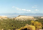
The Pajarito Plateau is a volcanic plateau
in north central New Mexico
, United States
. The plateau, part of the Jemez Mountains
, is bounded on the west by the Valles Caldera and on the east by the White Rock Canyon
of the Rio Grande
. The plateau is occupied by several notable entities, including Bandelier National Monument
, the town of Los Alamos
and its remote suburb White Rock
, and Los Alamos National Laboratory
. Elevations range from about 5600 feet (1700 meters) at the river to about 7800 feet (2300 meters) where the plateau merges into the mountain range.
The Pajarito Plateau is primarily composed of ignimbrite
, a voluminous deposit of volcanic tuff
laid down in an explosive eruption — in this case, a pair of eruptions from the nearby Valles Caldera. The two ignimbrite-forming eruptions occurred about 1.4 million and 1.1 million years ago and ejected about 300 cubic kilometers of rock each. The orange-pink rock formations constituting the resulting ignimbrites are known as the Otowi and Tshirege Members of the Bandelier tuff. The soft, friable tuff is stabilized by basalt
flows that interleave with the ignimbrites. The tuff lies on top of a volcanic field
, exposed to the east, which formerly was continuous with the Caja del Rio (now across the Rio Grande).
 Erosion
has created a maze of canyon
s up to 800 feet (240 meters) deep that dissect the plateau
into mesa
s. Many of these mesas climb on the western side rather than descending on all sides, thus sometimes are referred to as potrero
s. Rock climbing
is popular here with locals and visitors alike, and is done in the canyons on basalt cliffs that lie within and below the tuff, which itself is too soft to be climbed safely.
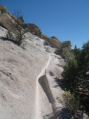 The canyons and mesas are highly scenic and well endowed with trail
s, about which numerous guidebooks have been written. Some trails reach the Rio Grande; others reach the rim of the Valles Caldera. Some are long distance trails, of which a few have been used for ultramarathon
s and endurance rides
. Popular uses include walking, dog walking, running, orienteering
and rogaining
, mountain biking, horse riding, and OHV-ing.
Due to constraints of geography and land ownership, both Los Alamos and White Rock are compact populated places. Outside of these, the plateau is sparsely populated and wildlife
is abundant and diverse. A large elk
herd that spends summers in the Jemez Mountains descends to the Pajarito Plateau during the winter, creating a significant driving hazard. Deer
, black bear
and coyote
are common, and the plateau and mountains support a small but stable population of mountain lions, which have on occasion been known to attack humans. Smaller mammals such as raccoon
s, skunk
s, and gopher
s are common. Parts of the Bandelier backcountry have been closed seasonally due to nesting bald eagle
s. The Rio Grande supports a significant migratory flyway
that brings many other birds (notably sandhill crane
s) to the plateau during migration
seasons, and three species of hummingbird
s are abundant during summer. White Rock Canyon, the major canyon containing the Rio Grande into which the plateau's canyons empty, is notorious for rattlesnake
s.
Volcanic plateau
A volcanic plateau is a plateau produced by volcanic activity. There are two main types: lava plateaus and pyroclastic plateaus.-Lava plateau:...
in north central New Mexico
New Mexico
New Mexico is a state located in the southwest and western regions of the United States. New Mexico is also usually considered one of the Mountain States. With a population density of 16 per square mile, New Mexico is the sixth-most sparsely inhabited U.S...
, United States
United States
The United States of America is a federal constitutional republic comprising fifty states and a federal district...
. The plateau, part of the Jemez Mountains
Jemez Mountains
The Jemez Mountains are a volcanic group of mountains in New Mexico, United States. The highest point in the range is Chicoma Mountain at an elevation of 11,561 feet . The town of Los Alamos and Los Alamos National Laboratory adjoin the eastern side of the range while the town of Jemez Springs...
, is bounded on the west by the Valles Caldera and on the east by the White Rock Canyon
White Rock, New Mexico
White Rock is a census-designated place in Los Alamos County, New Mexico, United States. The population was 6,045 at the 2000 census. It is largely a bedroom community for employees of Los Alamos National Laboratory and their families...
of the Rio Grande
Rio Grande
The Rio Grande is a river that flows from southwestern Colorado in the United States to the Gulf of Mexico. Along the way it forms part of the Mexico – United States border. Its length varies as its course changes...
. The plateau is occupied by several notable entities, including Bandelier National Monument
Bandelier National Monument
Bandelier National Monument is a National Monument preserving the homes of the Ancestral Pueblo People. It is named after Swiss anthropologist Adolph Bandelier, who researched the cultures of the area. Bandelier was designated a National Monument on February 11, 1916, and most of its backcountry...
, the town of Los Alamos
Los Alamos, New Mexico
Los Alamos is a townsite and census-designated place in Los Alamos County, New Mexico, United States, built upon four mesas of the Pajarito Plateau and the adjoining White Rock Canyon. The population of the CDP was 12,019 at the 2010 Census. The townsite or "the hill" is one part of town while...
and its remote suburb White Rock
White Rock, New Mexico
White Rock is a census-designated place in Los Alamos County, New Mexico, United States. The population was 6,045 at the 2000 census. It is largely a bedroom community for employees of Los Alamos National Laboratory and their families...
, and Los Alamos National Laboratory
Los Alamos National Laboratory
Los Alamos National Laboratory is a United States Department of Energy national laboratory, managed and operated by Los Alamos National Security , located in Los Alamos, New Mexico...
. Elevations range from about 5600 feet (1700 meters) at the river to about 7800 feet (2300 meters) where the plateau merges into the mountain range.
The Pajarito Plateau is primarily composed of ignimbrite
Ignimbrite
An ignimbrite is the deposit of a pyroclastic density current, or pyroclastic flow, a hot suspension of particles and gases that flows rapidly from a volcano, driven by a greater density than the surrounding atmosphere....
, a voluminous deposit of volcanic tuff
Tuff
Tuff is a type of rock consisting of consolidated volcanic ash ejected from vents during a volcanic eruption. Tuff is sometimes called tufa, particularly when used as construction material, although tufa also refers to a quite different rock. Rock that contains greater than 50% tuff is considered...
laid down in an explosive eruption — in this case, a pair of eruptions from the nearby Valles Caldera. The two ignimbrite-forming eruptions occurred about 1.4 million and 1.1 million years ago and ejected about 300 cubic kilometers of rock each. The orange-pink rock formations constituting the resulting ignimbrites are known as the Otowi and Tshirege Members of the Bandelier tuff. The soft, friable tuff is stabilized by basalt
Basalt
Basalt is a common extrusive volcanic rock. It is usually grey to black and fine-grained due to rapid cooling of lava at the surface of a planet. It may be porphyritic containing larger crystals in a fine matrix, or vesicular, or frothy scoria. Unweathered basalt is black or grey...
flows that interleave with the ignimbrites. The tuff lies on top of a volcanic field
Volcanic field
A volcanic field is an area of the Earth's crust that is prone to localized volcanic activity. They usually contain 10 to 100 volcanoes, such as cinder cones and are usually in clusters. Lava flows may also occur...
, exposed to the east, which formerly was continuous with the Caja del Rio (now across the Rio Grande).
Erosion
Erosion is when materials are removed from the surface and changed into something else. It only works by hydraulic actions and transport of solids in the natural environment, and leads to the deposition of these materials elsewhere...
has created a maze of canyon
Canyon
A canyon or gorge is a deep ravine between cliffs often carved from the landscape by a river. Rivers have a natural tendency to reach a baseline elevation, which is the same elevation as the body of water it will eventually drain into. This forms a canyon. Most canyons were formed by a process of...
s up to 800 feet (240 meters) deep that dissect the plateau
Dissected plateau
A dissected plateau is a plateau area that has been severely eroded so that the relief is sharp. Such an area may be referred to as mountainous, but dissected plateaus are distinguishable from orogenic mountain belts by the lack of folding, metamorphism, extensive faulting, or magmatic activity...
into mesa
Mesa
A mesa or table mountain is an elevated area of land with a flat top and sides that are usually steep cliffs. It takes its name from its characteristic table-top shape....
s. Many of these mesas climb on the western side rather than descending on all sides, thus sometimes are referred to as potrero
Potrero
-See also:*Potrero Hill, San Francisco, a neighborhood in San Francisco, California, USA*Potrero Chico, a rock climbing area in Mexico*Potrero Point, a land mass extending into San Francisco Bay, San Francisco, California*Point Potrero, Richmond, California...
s. Rock climbing
Rock climbing
Rock climbing also lightly called 'The Gravity Game', is a sport in which participants climb up, down or across natural rock formations or artificial rock walls. The goal is to reach the summit of a formation or the endpoint of a pre-defined route without falling...
is popular here with locals and visitors alike, and is done in the canyons on basalt cliffs that lie within and below the tuff, which itself is too soft to be climbed safely.
Trail
A trail is a path with a rough beaten or dirt/stone surface used for travel. Trails may be for use only by walkers and in some places are the main access route to remote settlements...
s, about which numerous guidebooks have been written. Some trails reach the Rio Grande; others reach the rim of the Valles Caldera. Some are long distance trails, of which a few have been used for ultramarathon
Ultramarathon
An ultramarathon is any sporting event involving running longer than the traditional marathon length of .There are two types of ultramarathon events: those that cover a specified distance, and events that take place during specified time...
s and endurance rides
Endurance riding
Endurance riding is an equestrian sport based on controlled long-distance races. It is one of the international competitions recognized by the FEI. There are endurance rides worldwide....
. Popular uses include walking, dog walking, running, orienteering
Orienteering
Orienteering is a family of sports that requires navigational skills using a map and compass to navigate from point to point in diverse and usually unfamiliar terrain, and normally moving at speed. Participants are given a topographical map, usually a specially prepared orienteering map, which they...
and rogaining
Rogaining
Rogaining is a sport of long distance cross-country navigation, involving both route planning and navigation between checkpoints using a variety of map types. In a rogaine, teams of 2-5 people choose which checkpoints to visit within a time limit with the intent of maximizing their score...
, mountain biking, horse riding, and OHV-ing.
Due to constraints of geography and land ownership, both Los Alamos and White Rock are compact populated places. Outside of these, the plateau is sparsely populated and wildlife
Wildlife
Wildlife includes all non-domesticated plants, animals and other organisms. Domesticating wild plant and animal species for human benefit has occurred many times all over the planet, and has a major impact on the environment, both positive and negative....
is abundant and diverse. A large elk
Elk
The Elk is the large deer, also called Cervus canadensis or wapiti, of North America and eastern Asia.Elk may also refer to:Other antlered mammals:...
herd that spends summers in the Jemez Mountains descends to the Pajarito Plateau during the winter, creating a significant driving hazard. Deer
Deer
Deer are the ruminant mammals forming the family Cervidae. Species in the Cervidae family include white-tailed deer, elk, moose, red deer, reindeer, fallow deer, roe deer and chital. Male deer of all species and female reindeer grow and shed new antlers each year...
, black bear
American black bear
The American black bear is a medium-sized bear native to North America. It is the continent's smallest and most common bear species. Black bears are omnivores, with their diets varying greatly depending on season and location. They typically live in largely forested areas, but do leave forests in...
and coyote
Coyote
The coyote , also known as the American jackal or the prairie wolf, is a species of canine found throughout North and Central America, ranging from Panama in the south, north through Mexico, the United States and Canada...
are common, and the plateau and mountains support a small but stable population of mountain lions, which have on occasion been known to attack humans. Smaller mammals such as raccoon
Raccoon
Procyon is a genus of nocturnal mammals, comprising three species commonly known as raccoons, in the family Procyonidae. The most familiar species, the common raccoon , is often known simply as "the" raccoon, as the two other raccoon species in the genus are native only to the tropics and are...
s, skunk
Skunk
Skunks are mammals best known for their ability to secrete a liquid with a strong, foul odor. General appearance varies from species to species, from black-and-white to brown or cream colored. Skunks belong to the family Mephitidae and to the order Carnivora...
s, and gopher
Gopher (animal)
The term gopher as it is commonly used does not relate to any one species, but is a generic term used to describe any of several small burrowing rodents endemic to North America, including the pocket gopher , also called true gophers, and the ground squirrel , including Richardson's ground squirrel...
s are common. Parts of the Bandelier backcountry have been closed seasonally due to nesting bald eagle
Bald Eagle
The Bald Eagle is a bird of prey found in North America. It is the national bird and symbol of the United States of America. This sea eagle has two known sub-species and forms a species pair with the White-tailed Eagle...
s. The Rio Grande supports a significant migratory flyway
Flyway
A flyway is a flight path used in bird migration. Flyways generally span over continents and often oceans.-Flyways of the Americas:*Atlantic Flyway*Central Flyway*Mississippi Flyway*Pacific Flyway*Allegheny Front...
that brings many other birds (notably sandhill crane
Sandhill Crane
The Sandhill Crane is a large crane of North America and extreme northeastern Siberia. The common name of this bird references habitat like that at the Platte River, on the edge of Nebraska's Sandhills in the American Midwest...
s) to the plateau during migration
Bird migration
Bird migration is the regular seasonal journey undertaken by many species of birds. Bird movements include those made in response to changes in food availability, habitat or weather. Sometimes, journeys are not termed "true migration" because they are irregular or in only one direction...
seasons, and three species of hummingbird
Hummingbird
Hummingbirds are birds that comprise the family Trochilidae. They are among the smallest of birds, most species measuring in the 7.5–13 cm range. Indeed, the smallest extant bird species is a hummingbird, the 5-cm Bee Hummingbird. They can hover in mid-air by rapidly flapping their wings...
s are abundant during summer. White Rock Canyon, the major canyon containing the Rio Grande into which the plateau's canyons empty, is notorious for rattlesnake
Rattlesnake
Rattlesnakes are a group of venomous snakes of the genera Crotalus and Sistrurus of the subfamily Crotalinae . There are 32 known species of rattlesnake, with between 65-70 subspecies, all native to the Americas, ranging from southern Alberta and southern British Columbia in Canada to Central...
s.
See also
- Bandelier National MonumentBandelier National MonumentBandelier National Monument is a National Monument preserving the homes of the Ancestral Pueblo People. It is named after Swiss anthropologist Adolph Bandelier, who researched the cultures of the area. Bandelier was designated a National Monument on February 11, 1916, and most of its backcountry...
- Caja del Rio
- Jemez MountainsJemez MountainsThe Jemez Mountains are a volcanic group of mountains in New Mexico, United States. The highest point in the range is Chicoma Mountain at an elevation of 11,561 feet . The town of Los Alamos and Los Alamos National Laboratory adjoin the eastern side of the range while the town of Jemez Springs...
- Rio Grande RiftRio Grande RiftThe Rio Grande Rift is a north-trending continental rift zone. It separates the Colorado Plateau in the west from the interior of the North American craton on the east. The rift extends from central Colorado in the north to the state of Chihuahua, Mexico in the south. The rift zone consists of four...