
Otis, Massachusetts
Encyclopedia
Otis is a town
in Berkshire County
, Massachusetts
, United States
. It is part of the Pittsfield
, Massachusetts
Metropolitan Statistical Area. The population was 1,365 at the 2000 census.
For geographic and demographic information on East Otis, which is part of the town of Otis, see East Otis
, Massachusetts
. The numbers reported in that article are included in the figures below.
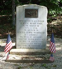
passed through the town in January 1776, bringing cannons from Fort Ticonderoga
in New York to aid in ending the Siege of Boston
, a route now known as the Knox Trail
. The town was a farming community, with several small mill industries growing along the waterways, and today is mostly rural with some tourism.
, the town has a total area of 38 square miles (98.4 km²), of which, 35.8 square miles (92.7 km²) of it is land and 2.2 square miles (5.7 km²) of it (5.76%) is water. Otis lies along the eastern border of Berkshire county with Hampden County
bordered by Becket
to the north, Blandford
to the east, Tolland
to the southeast, Sandisfield
to the south, and Monterey
and Tyringham
to the west. Otis is 23 miles southeast of Pittsfield
, 30 miles west-northwest of Springfield
, and 116 miles west of Boston.
Otis lies in the southern end of the Berkshire Mountains, and is dotted by several hills. The West Branch of the Farmington River
rises in the town, heading southward towards the Connecticut River
. The southeastern part of town is dominated by the Otis Reservoir
and Big Pond, Otis MA
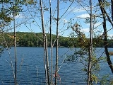
, as well as portions of Tolland State Forest and Otis State Forest. The highest points in the town are to the north, with Church Hill to the east and Kingsbury Mountain to the west. Much of the land around the brooks of town are marshy. Just west of the town center is Otis Ridge Ski Area. Most of the population is around the reservoir and the center of town.
Otis lies at the intersection of Route 8 and Route 23. Route 8 was once part of the New England interstate system, as the Stratford-Waterbury-North Adams Route. Route 23 is known as the Knox Trail, with a historical marker along the route in the eastern part of town. Interstate 90
(also known as the Massachusetts Turnpike
) passes through the northern edge of town twice, with the nearest exit being in Lee. There is no rail, bus or air service in town, with the nearest being in Pittsfield and Westfield. The nearest national air service is at Bradley International Airport
in Windsor Locks
, Connecticut
.
 As of the census
of 2000, there were 1,365 people, 567 households, and 386 families residing in the town. By population, Otis ranks 19th out of the 32 cities and towns in Berkshire County, and 312nd out of 351 cities and towns in Massachusetts. The population density
was 38.1 people per square mile (14.7/km²), which ranks it 18th in the county and 312th in the Commonwealth. There were 1,572 housing units at an average density of 43.9 per square mile (16.9/km²). The racial makeup of the town was 96.56% White, 0.59% African American, 0.29% Native American, 0.88% Asian, 0.37% from other races
, and 1.32% from two or more races. Hispanic or Latino of any race were 0.29% of the population.
There were 567 households out of which 26.6% had children under the age of 18 living with them, 59.1% were married couples
living together, 5.5% had a female householder with no husband present, and 31.9% were non-families. 24.3% of all households were made up of individuals and 7.6% had someone living alone who was 65 years of age or older. The average household size was 2.40 and the average family size was 2.90.
In the town the population was spread out with 21.8% under the age of 18, 5.7% from 18 to 24, 28.1% from 25 to 44, 30.3% from 45 to 64, and 14.1% who were 65 years of age or older. The median age was 42 years. For every 100 females there were 111.6 males. For every 100 females age 18 and over, there were 108.2 males.
The median income for a household in the town was $51,488, and the median income for a family was $55,455. Males had a median income of $41,065 versus $30,179 for females. The per capita income
for the town was $25,029. About 4.6% of families and 7.4% of the population were below the poverty line, including 11.4% of those under age 18 and 4.2% of those age 65 or over.
 Otis uses the open town meeting
form of government, and is led by a board of selectmen
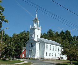
and an administrative assistant. All four of the town's main offices, including the town hall, police and fire departments and the town library, are all located at the center of town, as is the central post office. A second post office is located in East Otis. The library is a part of the regional library systems. The nearest hospital, Noble Hospital, is twenty miles away in Westfield.
On the state level, Otis is represented in the Massachusetts House of Representatives
by the Fourth Berkshire district, which covers southern Berkshire County, as well as the westernmost towns in Hampden County. In the Massachusetts Senate
, the town is represented by the Berkshire, Hampshire and Franklin district, which includes all of Berkshire County and western Hampshire and Franklin Counties. The town is patrolled by the First (Lee) Station of Barracks "B" of the Massachusetts State Police
.
On the national level, Otis is represented in the United States House of Representatives
as part of Massachusetts's 1st congressional district
, and has been represented by John Olver
of Amherst
since June 1991. Massachusetts is currently represented in the United States Senate
by senior Senator John Kerry
and junior senator Scott Brown.
based Monument Valley Regional Middle School and Monument Mountain Regional High School or (2) Lee
Middle/High School. Proximity to private schools located in Lenox, Great Barrington, or Westfield allow alternatives to public school.
The nearest community college is Berkshire Community College
in Pittsfield and Great Barrington. The nearest state college is Westfield State College
, and the nearest state university is the University of Massachusetts Amherst
. The nearest private college is Bard College at Simon's Rock in Great Barrington, with other private colleges in Springfield.
New England town
The New England town is the basic unit of local government in each of the six New England states. Without a direct counterpart in most other U.S. states, New England towns are conceptually similar to civil townships in other states, but are incorporated, possessing powers like cities in other...
in Berkshire County
Berkshire County, Massachusetts
Berkshire County is a non-governmental county located on the western edge of the U.S. state of Massachusetts. As of the 2010 census, the population was 131,219. Its largest city and traditional county seat is Pittsfield...
, Massachusetts
Massachusetts
The Commonwealth of Massachusetts is a state in the New England region of the northeastern United States of America. It is bordered by Rhode Island and Connecticut to the south, New York to the west, and Vermont and New Hampshire to the north; at its east lies the Atlantic Ocean. As of the 2010...
, United States
United States
The United States of America is a federal constitutional republic comprising fifty states and a federal district...
. It is part of the Pittsfield
Pittsfield, Massachusetts
Pittsfield is the largest city and the county seat of Berkshire County, Massachusetts, United States. It is the principal city of the Pittsfield, Massachusetts Metropolitan Statistical Area which encompasses all of Berkshire County. Its area code is 413. Its ZIP code is 01201...
, Massachusetts
Massachusetts
The Commonwealth of Massachusetts is a state in the New England region of the northeastern United States of America. It is bordered by Rhode Island and Connecticut to the south, New York to the west, and Vermont and New Hampshire to the north; at its east lies the Atlantic Ocean. As of the 2010...
Metropolitan Statistical Area. The population was 1,365 at the 2000 census.
For geographic and demographic information on East Otis, which is part of the town of Otis, see East Otis
East Otis, Massachusetts
East Otis is part of the town of Otis in Berkshire County, Massachusetts. As of the 2000 census, East Otis had a total population of 572.- Geography :According to the United States Census Bureau, East Otis has a total area of 14.12 mi²...
, Massachusetts
Massachusetts
The Commonwealth of Massachusetts is a state in the New England region of the northeastern United States of America. It is bordered by Rhode Island and Connecticut to the south, New York to the west, and Vermont and New Hampshire to the north; at its east lies the Atlantic Ocean. As of the 2010...
. The numbers reported in that article are included in the figures below.
History
Officially incorporated in 1810, the town was created when the unincorporated town of Loudon annexed the adjacent District of Bethlehem in 1809. It was named after Harrison Gray Otis, an influential lawyer, financier, and politician in revolutionary Massachusetts. General Henry KnoxHenry Knox
Henry Knox was a military officer of the Continental Army and later the United States Army, and also served as the first United States Secretary of War....
passed through the town in January 1776, bringing cannons from Fort Ticonderoga
Fort Ticonderoga
Fort Ticonderoga, formerly Fort Carillon, is a large 18th-century fort built by the Canadians and the French at a narrows near the south end of Lake Champlain in upstate New York in the United States...
in New York to aid in ending the Siege of Boston
Siege of Boston
The Siege of Boston was the opening phase of the American Revolutionary War, in which New England militiamen—who later became part of the Continental Army—surrounded the town of Boston, Massachusetts, to prevent movement by the British Army garrisoned within...
, a route now known as the Knox Trail
Henry Knox Trail
The Henry Knox Trail, also known as the Knox Cannon Trail, is a network of roads and paths that traces the route of Colonel Henry Knox's "noble train of artillery" from Fort Ticonderoga to the Continental Army camp outside Boston, Massachusetts early in the American Revolutionary War.-History:Knox...
. The town was a farming community, with several small mill industries growing along the waterways, and today is mostly rural with some tourism.
Geography
According to the United States Census BureauUnited States Census Bureau
The United States Census Bureau is the government agency that is responsible for the United States Census. It also gathers other national demographic and economic data...
, the town has a total area of 38 square miles (98.4 km²), of which, 35.8 square miles (92.7 km²) of it is land and 2.2 square miles (5.7 km²) of it (5.76%) is water. Otis lies along the eastern border of Berkshire county with Hampden County
Hampden County, Massachusetts
-Demographics:As of the census of 2004, there were 461,228 people, 175,288 households, and 115,690 families residing in the county. The population density was 738 people per square mile . There were 185,876 housing units at an average density of 301 per square mile...
bordered by Becket
Becket, Massachusetts
Becket is a town in Berkshire County, Massachusetts, United States. It is part of the Pittsfield, Massachusetts Metropolitan Statistical Area. The population was 1,779 at the 2010 census.- History :...
to the north, Blandford
Blandford, Massachusetts
Blandford is a town in Hampden County, Massachusetts, United States. The population was 1,233 at the 2010 census. It is part of the Springfield, Massachusetts Metropolitan Statistical Area. It is the home of the Blandford Ski Area.- History :...
to the east, Tolland
Tolland, Massachusetts
Tolland is a town in Hampden County, Massachusetts, United States. The population was 485 at the 2010 census, making it the smallest town in Hampden County by population. It is part of the Springfield, Massachusetts Metropolitan Statistical Area. Tolland formerly had a popular "Black Fly Day"...
to the southeast, Sandisfield
Sandisfield, Massachusetts
Sandisfield is a town in Berkshire County, Massachusetts, United States. It is part of the Pittsfield, Massachusetts Metropolitan Statistical Area. The population was 824 at the 2000 census.- History :...
to the south, and Monterey
Monterey, Massachusetts
Monterey is a town in Berkshire County, Massachusetts, United States. It is part of the Pittsfield, Massachusetts Metropolitan Statistical Area. The population was 934 at the 2000 census.- History :...
and Tyringham
Tyringham, Massachusetts
Tyringham is a town in Berkshire County, Massachusetts, United States. It is part of the Pittsfield, Massachusetts Metropolitan Statistical Area. The population was 327 at the 2010 census.- History :...
to the west. Otis is 23 miles southeast of Pittsfield
Pittsfield, Massachusetts
Pittsfield is the largest city and the county seat of Berkshire County, Massachusetts, United States. It is the principal city of the Pittsfield, Massachusetts Metropolitan Statistical Area which encompasses all of Berkshire County. Its area code is 413. Its ZIP code is 01201...
, 30 miles west-northwest of Springfield
Springfield, Massachusetts
Springfield is the most populous city in Western New England, and the seat of Hampden County, Massachusetts, United States. Springfield sits on the eastern bank of the Connecticut River near its confluence with three rivers; the western Westfield River, the eastern Chicopee River, and the eastern...
, and 116 miles west of Boston.
Otis lies in the southern end of the Berkshire Mountains, and is dotted by several hills. The West Branch of the Farmington River
Farmington River
The Farmington River is a river located in northwest Connecticut, with major tributaries extending into southwest Massachusetts. Via its longest branch , the Farmington's length increases to , making it the Connecticut River's longest tributary by a mere over the major river directly to its...
rises in the town, heading southward towards the Connecticut River
Connecticut River
The Connecticut River is the largest and longest river in New England, and also an American Heritage River. It flows roughly south, starting from the Fourth Connecticut Lake in New Hampshire. After flowing through the remaining Connecticut Lakes and Lake Francis, it defines the border between the...
. The southeastern part of town is dominated by the Otis Reservoir
Otis Reservoir
Otis Reservoir is a reservoir located primarily in Otis, Massachusetts. Small portions are also in Tolland, MA, and Blandford, MA. The lake is popular for boating, swimming, fishing, water skiing, snowmobiling, camping, and water-related recreation. Fish include lake trout, bass, white perch,...
and Big Pond, Otis MA
Big Pond, Otis MA
Big Pond is a lake located in Otis, Massachusetts. The lake is popular for boating, swimming, fishing, water skiing, snowmobiling, camping, and water-related recreation. Fish include lake trout, bass, white perch, yellow perch, catfish, and bluegills...
, as well as portions of Tolland State Forest and Otis State Forest. The highest points in the town are to the north, with Church Hill to the east and Kingsbury Mountain to the west. Much of the land around the brooks of town are marshy. Just west of the town center is Otis Ridge Ski Area. Most of the population is around the reservoir and the center of town.
Otis lies at the intersection of Route 8 and Route 23. Route 8 was once part of the New England interstate system, as the Stratford-Waterbury-North Adams Route. Route 23 is known as the Knox Trail, with a historical marker along the route in the eastern part of town. Interstate 90
Interstate 90
Interstate 90 is the longest Interstate Highway in the United States at . It is the northernmost coast-to-coast interstate, and parallels US 20 for the most part. Its western terminus is in Seattle, at Edgar Martinez Drive S. near Safeco Field and CenturyLink Field, and its eastern terminus is in...
(also known as the Massachusetts Turnpike
Massachusetts Turnpike
The Massachusetts Turnpike is the easternmost stretch of Interstate 90. The Turnpike begins at the western border of Massachusetts in West Stockbridge connecting with the Berkshire Connector portion of the New York State Thruway...
) passes through the northern edge of town twice, with the nearest exit being in Lee. There is no rail, bus or air service in town, with the nearest being in Pittsfield and Westfield. The nearest national air service is at Bradley International Airport
Bradley International Airport
Bradley International Airport is a joint civil-military public airport located in Windsor Locks on the border with East Granby and Suffield, in Hartford County, Connecticut, United States. It is owned by the State of Connecticut....
in Windsor Locks
Windsor Locks, Connecticut
Windsor Locks is a town located in Hartford County, Connecticut, United States. As of the 2000 census, its population was 12,043. It is the site of Bradley International Airport, which serves the Greater Hartford-Springfield region. It is also the site of the New England Air Museum...
, Connecticut
Connecticut
Connecticut is a state in the New England region of the northeastern United States. It is bordered by Rhode Island to the east, Massachusetts to the north, and the state of New York to the west and the south .Connecticut is named for the Connecticut River, the major U.S. river that approximately...
.
Demographics
Census
A census is the procedure of systematically acquiring and recording information about the members of a given population. It is a regularly occurring and official count of a particular population. The term is used mostly in connection with national population and housing censuses; other common...
of 2000, there were 1,365 people, 567 households, and 386 families residing in the town. By population, Otis ranks 19th out of the 32 cities and towns in Berkshire County, and 312nd out of 351 cities and towns in Massachusetts. The population density
Population density
Population density is a measurement of population per unit area or unit volume. It is frequently applied to living organisms, and particularly to humans...
was 38.1 people per square mile (14.7/km²), which ranks it 18th in the county and 312th in the Commonwealth. There were 1,572 housing units at an average density of 43.9 per square mile (16.9/km²). The racial makeup of the town was 96.56% White, 0.59% African American, 0.29% Native American, 0.88% Asian, 0.37% from other races
Race (United States Census)
Race and ethnicity in the United States Census, as defined by the Federal Office of Management and Budget and the United States Census Bureau, are self-identification data items in which residents choose the race or races with which they most closely identify, and indicate whether or not they are...
, and 1.32% from two or more races. Hispanic or Latino of any race were 0.29% of the population.
There were 567 households out of which 26.6% had children under the age of 18 living with them, 59.1% were married couples
Marriage
Marriage is a social union or legal contract between people that creates kinship. It is an institution in which interpersonal relationships, usually intimate and sexual, are acknowledged in a variety of ways, depending on the culture or subculture in which it is found...
living together, 5.5% had a female householder with no husband present, and 31.9% were non-families. 24.3% of all households were made up of individuals and 7.6% had someone living alone who was 65 years of age or older. The average household size was 2.40 and the average family size was 2.90.
In the town the population was spread out with 21.8% under the age of 18, 5.7% from 18 to 24, 28.1% from 25 to 44, 30.3% from 45 to 64, and 14.1% who were 65 years of age or older. The median age was 42 years. For every 100 females there were 111.6 males. For every 100 females age 18 and over, there were 108.2 males.
The median income for a household in the town was $51,488, and the median income for a family was $55,455. Males had a median income of $41,065 versus $30,179 for females. The per capita income
Per capita income
Per capita income or income per person is a measure of mean income within an economic aggregate, such as a country or city. It is calculated by taking a measure of all sources of income in the aggregate and dividing it by the total population...
for the town was $25,029. About 4.6% of families and 7.4% of the population were below the poverty line, including 11.4% of those under age 18 and 4.2% of those age 65 or over.
Government
Open town meeting
An open town meeting is a form of town meeting in which all registered voters of a town may vote . This form of government is typical of smaller municipalities in the New England region of the United States....
form of government, and is led by a board of selectmen
Board of selectmen
The board of selectmen is commonly the executive arm of the government of New England towns in the United States. The board typically consists of three or five members, with or without staggered terms.-History:...
and an administrative assistant. All four of the town's main offices, including the town hall, police and fire departments and the town library, are all located at the center of town, as is the central post office. A second post office is located in East Otis. The library is a part of the regional library systems. The nearest hospital, Noble Hospital, is twenty miles away in Westfield.
On the state level, Otis is represented in the Massachusetts House of Representatives
Massachusetts House of Representatives
The Massachusetts House of Representatives is the lower house of the Massachusetts General Court, the state legislature of the Commonwealth of Massachusetts. It is composed of 160 members elected from single-member electoral districts across the Commonwealth. Representatives serve two-year terms...
by the Fourth Berkshire district, which covers southern Berkshire County, as well as the westernmost towns in Hampden County. In the Massachusetts Senate
Massachusetts Senate
The Massachusetts Senate is the upper house of the Massachusetts General Court, the bicameral state legislature of the Commonwealth of Massachusetts. The Senate comprises 40 elected members from 40 single-member senatorial districts in the state...
, the town is represented by the Berkshire, Hampshire and Franklin district, which includes all of Berkshire County and western Hampshire and Franklin Counties. The town is patrolled by the First (Lee) Station of Barracks "B" of the Massachusetts State Police
Massachusetts State Police
The Massachusetts State Police is an agency of the Commonwealth of Massachusetts' Executive Office of Public Safety and Security responsible for criminal law enforcement and traffic vehicle regulation across the state...
.
On the national level, Otis is represented in the United States House of Representatives
United States House of Representatives
The United States House of Representatives is one of the two Houses of the United States Congress, the bicameral legislature which also includes the Senate.The composition and powers of the House are established in Article One of the Constitution...
as part of Massachusetts's 1st congressional district
Massachusetts's 1st congressional district
Massachusetts's 1st congressional district is in western and central Massachusetts. The largest Massachusetts district in area, it covers about one-third of the state and is more rural than the rest. It has the state's highest point, Mount Greylock...
, and has been represented by John Olver
John Olver
John Walter Olver is the U.S. Representative for , serving since 1991. He is a member of the Democratic Party. Early in his career, he was a chemistry professor and served in both chambers of the Massachusetts General Court....
of Amherst
Amherst, Massachusetts
Amherst is a town in Hampshire County, Massachusetts, United States in the Connecticut River valley. As of the 2010 census, the population was 37,819, making it the largest community in Hampshire County . The town is home to Amherst College, Hampshire College, and the University of Massachusetts...
since June 1991. Massachusetts is currently represented in the United States Senate
United States Senate
The United States Senate is the upper house of the bicameral legislature of the United States, and together with the United States House of Representatives comprises the United States Congress. The composition and powers of the Senate are established in Article One of the U.S. Constitution. Each...
by senior Senator John Kerry
John Kerry
John Forbes Kerry is the senior United States Senator from Massachusetts, the 10th most senior U.S. Senator and chairman of the Senate Foreign Relations Committee. He was the presidential nominee of the Democratic Party in the 2004 presidential election, but lost to former President George W...
and junior senator Scott Brown.
Education
Otis, along with neighboring Sandisfield, Tolland,and Becket, is part of the Farmington River Regional School District. The district's only school, Farmington River Elementary School, houses students from pre-kindergarten through sixth grades. For the upper grades, most students attend either (1) Great BarringtonGreat Barrington
Great Barrington is the name of more than one place:*Great Barrington, Gloucestershire in England*Great Barrington, Massachusetts in the United States...
based Monument Valley Regional Middle School and Monument Mountain Regional High School or (2) Lee
Lee, Massachusetts
Lee is a town in Berkshire County, Massachusetts, United States. It is part of the Pittsfield, Massachusetts, metropolitan statistical area. The population was 5,943 which was determined in the 2010 census. Lee, which includes the villages of South and East Lee, is part of the Berkshires resort...
Middle/High School. Proximity to private schools located in Lenox, Great Barrington, or Westfield allow alternatives to public school.
The nearest community college is Berkshire Community College
Berkshire Community College
Berkshire Community College is a two-year community college in Berkshire County, Massachusetts, United States. It offers associate degrees as well as a transfer program for students to earn credits for transfer to other colleges...
in Pittsfield and Great Barrington. The nearest state college is Westfield State College
Westfield State College
Westfield State University is a comprehensive, coeducational, four-year public university in Westfield, Massachusetts. It was founded in 1838 by noted educator and social reformer Horace Mann as the first public co-educational college in America without barrier to race, gender and economic class...
, and the nearest state university is the University of Massachusetts Amherst
University of Massachusetts Amherst
The University of Massachusetts Amherst is a public research and land-grant university in Amherst, Massachusetts, United States and the flagship of the University of Massachusetts system...
. The nearest private college is Bard College at Simon's Rock in Great Barrington, with other private colleges in Springfield.