
New York State Route 28
Encyclopedia
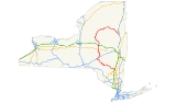
New York State Route 28 (NY 28) is a state highway
extending for 281.69 miles (453.33 km) in the shape of a "C" between the Hudson Valley
city of Kingston
and southern Warren County
in the U.S. state
of New York
. Along the way, it intersects several major routes, including Interstate 88
(I-88), U.S. Route 20 (US 20), and the New York State Thruway
twice. The southern terminus of NY 28 is at NY 32
in Kingston and the northern terminus is US 9 in Warrensburg
. In Kingston, NY 28 is co-designated
as Interstate 587 from its southern terminus at NY 32 to the roundabout
linking it to the Thruway (I-87).
NY 28 was originally assigned in 1924 to an alignment extending from Colliersville in the south to Utica
in the north via Ilion
. From Colliersville to Cooperstown
, the highway followed its current routing (excluding minor realignments); north of Cooperstown, NY 28 was routed along several state highways that now have other designations. The route was extended south to Kingston and north to Warrensburg as part of the 1930 renumbering of state highways in New York. At the same time, Route 28 was realigned between Cooperstown and Mohawk
to follow its modern routing. Other than minor realignments in Kingston, Oneonta, and Oneida County
, NY 28 has remained the same to this day.
(Albany Avenue) in the city of Kingston. The route heads north, then northwest on Colonel Chandler Drive, a four-lane limited-access highway. The roadway is also designated and signed as I-587, which begins at NY 32 as well. Although Colonel Chandler Drive is built to Interstate Highway standards
, it has no intermediary interchanges. After crossing over the Esopus Creek
into Ulster
, I-587 terminates at a roundabout
linking I-587 and NY 28 to the New York State Thruway
(I-87
) at exit 19.
West of I-87, the route crosses the Blue Line
of Catskill Park and becomes the Onteora Trail. Although still four lanes wide, the route is no longer a limited-access highway as it has an at-grade intersection
with Modica Lane, a local dead-end street, just west of where it passes over the Thruway. Not long afterward, the highway meets US 209 by way of a cloverleaf interchange
. Past US 209, the highway enters a rural area as it heads northwest into the center of the state park.
Near the eastern tip of the Ashokan Reservoir
, in the town of Kingston
, Route 28 intersects the eastern terminus of NY 28A
. West of NY 28A, Route 28 continues towards the north and west along the northern edge of the reservoir. In West Hurley
, the route intersects the southern terminus of NY 375
. It proceeds along the reservoir to its western end in the town of Olive
community of Boiceville, where NY 28A reconnects to the route. Here the mountains begin to loom over the road, with Mount Tremper
dominating the view to the north as the route continues along Esopus Creek
into the town of Shandaken
after passing the southern terminus of NY 212
at Mount Pleasant
. At Phoenicia
, the largest settlement since Kingston, NY 214
reaches its southern terminus at the highway.
Past Phoenicia, the surrounding slopes become steeper as the road and creek curve around Panther Mountain
, one of the Catskill High Peaks
, to the south. At Allaben, the Shandaken Tunnel
crosses under the road, bringing water from Schoharie Reservoir
into the creek. The road and creek start bending to the south to the hamlet of Shandaken, where the town hall on the south side of the road is followed by the southern terminus of NY 42
's northern segment. As Route 28 continues trending southwest, the valley becomes less developed. Balsam Mountain
, another High Peak, looms ahead.
The northern terminus of Route 42's southern segment marks the small hamlet of Big Indian
, after which Esopus Creek crosses for the last time, turning south to its source at Winnisook Lake
. The road begins a sustained climb over the next two miles paralleling an Esopus tributary, Birch Creek, up to Pine Hill
. At the road to Belleayre Ski Center
, in Highmount, the last junction before it leaves the Catskill Park and enters Delaware County
, it is for the first time signed as a north–south route.
, the highway shifts towards the west. Route 28 begins a concurrency
with NY 30
in Margaretville
, with the routes paralleling the East Branch of the Delaware River
. After crossing the Delaware River, the route ends its concurrency with Route 30, and NY 28 continues northwest through Andes as Main Street and Delaware Avenue. In the village of Delhi
, the highway becomes known as Andes Road and has a short concurrency with NY 10
in the village center. North of Delhi, it continues north towards the hamlet of Meredith
, proceeding west past the hamlet. In Franklin
, Route 28 makes a 90-degree turn to the north at the intersection with the eastern end of NY 357
.
Once in Otsego County
, it traverses an s-curve before veering to the east to follow the southern bank of the Susquehanna River
through the town of Oneonta
. The route initially connects to the city of Oneonta, which is located across the river from Route 28, via Main Street. Shortly afterward, Route 28 meets Route 23
. The route turns north, overlapping Route 23 along the four-lane James F. Lettis Highway. The two routes cross the River and enter the Oneonta city limits before separating at I-88
exit 15. NY 23 continues north on the arterial; however, NY 28 joins I-88 eastward out of the city.
Back in the town of Oneonta, the overlap between Route 28 and I-88 continues along the northern bank of the Susquehanna toward the hamlet of Emmons, where the expressway meets County Route 47 (CR 47) at exit 16. The overlap ends at exit 17 in Milford
; however, NY 28 remains in close proximity to the Susquehanna River, which turns northward at the interchange. Roughly 0.75 miles (1.21 km) north of I-88, the highway passes over Route 7
with no access between the two. After another 0.75 miles (1.21 km), the route meets D.K. Lifgren Drive (unsigned Route 992G), a connector providing access between Routes 7 and 28. North of Goodyear Lake, a body of water situated 1 miles (1.6 km) north of Lifgren Drive, the highway parallels the Susquehanna to the village of Milford
, where it intersects the southern terminus of Route 166
.
 The highway continues northward along the banks of the Susquehanna to the village of Cooperstown
, home to the National Baseball Hall of Fame. Inside the village, the route is initially known as Chestnut Street. Two blocks from the business district of the village, it intersects Route 80
, which occupies Chestnut Street north of this point. Both routes turn west, overlapping each other as the routes leave the village. The portion of the highway between the southern border of the village of Cooperstown and the northern intersection with Grove Street is maintained by the village, and is the only section of the route not maintained by the New York State Department of Transportation
(NYSDOT). Routes 28 and 80 head towards the northwest, passing by the now-abandoned Cooperstown Airport. In Otsego
, the Route 28/80 concurrency ends. It continues northward as it passes Canadarago Lake
. In Richfield Springs
, the highway has a concurrency with US 20
for 0.5 mile (0.80467 km). North of Route 20, the highway exits Otsego County.
, Route 28 becomes Columbia Street and intersects the northern terminus of NY 168
. In Mohawk
, NY 28 intersects NY 5S
. After crossing the Mohawk River
, Route 28 becomes Mohawk Street and meets I-90 (New York State Thruway
) at exit 30. In the village of Herkimer
, Route 28 has a concurrency with NY 5
. North of Route 5, Route 28 begins to parallel the West Canada Creek
. In Middleville
, it intersects the western terminus of NY 29
and the northern terminus of NY 169
. The highway executes a 90-degree turn at the three-route junction. Route 28 continues towards the north paralleling the West Canada Creek. In Poland
, NY 28 begins a concurrency with NY 8
.
 In Deerfield
, Oneida County
, NY 28 splits from Route 8. Route 28 crosses the West Canada Creek and leaves Oneida County for about 3 miles (5 km), then re-crosses the creek and enters Oneida County again. In Trenton
, Route 28 joins NY 12
northward toward Barneveld
. In Barneveld, Route 12 and Route 28 intersect NY 365
. Route 28 splits from NY 12 in Remsen
and heads toward the northeast, passing through numerous lakes and reservoirs. In Forestport
, it enters Adirondack Park as it parallels the Adirondack Mountains
.
Route 28 briefly reenters Herkimer County, but does not have any major junctions. Route 28 passes the Fulton Chain Lakes
, among several other large lakes, as it winds through the Adirondack Park.
as it passes south of Raquette Lake
. In the hamlet of Blue Mountain Lake
, the route begins a concurrency with NY 30
; the concurrency ends in the hamlet of Indian Lake
. East of Route 30, Route 28 begins to shift towards the south.
Route 28 enters Warren County paralleling the Hudson River
. In North Creek
, it intersects the southern terminus of NY 28N
. The highway continues towards the south opposite to its original course. In Wevertown
, it intersects NY 8
. It continues towards the southeast paralleling the Hudson River and in Warrensburg
, Route 28 comes to an end at a "Y" intersection with US 9.
in the State of Connecticut
to the Susquehanna River
at or near the Town of Jericho (now Bainbridge
)". The portion of the Ulster and Delaware Turnpike east of the Hudson River
was also commonly known as the Ulster and Salisbury Turnpike or the Salisbury Turnpike. West of the river, the turnpike connected Kingston
to modern-day Bainbridge
. It then followed modern NY 28 west from Kingston up to the hamlet of Andes
. From Andes, the turnpike alignment left NY 28 to follow modern Delaware County Road 2 to De Lancey, NY 10
to Walton, and NY 206
to the Village of Bainbridge
. The turnpike crossed the river via the Kingston-Rhinecliff Ferry and used modern Rhinecliff Road and West Market Street to the village center of Rhinecliff, then roughly followed modern-day NY 308
to the hamlet of Eighmyville. It continued east from there using part of present-day CR 52 to eventually connect with and follow the route of current NY 199
. The turnpike corporation operated through the late 19th century.
. At the time, NY 28 began at then-NY 9 in Colliersville and headed north on its current alignment to Cooperstown
. NY 28 separated from its modern routing and continued to Springfield
north of Cooperstown on what is now NY 80
. Between Springfield and Richfield Springs
, the highway utilized what is now US 20. At Richfield Springs, the highway turned north onto modern NY 167
and followed the current alignments of NY 167—NY 168
, and NY 5S
, as well as a small portion of its current alignment in Mohawk
—north, then west, through Ilion
to its terminus in Utica.
In 1924, what is now NY 28 was part of NY 19 from Kingston
to Margaretville
(where NY 19 turned north to follow modern NY 30
to Grand Gorge
), NY 9 from Oneonta to Colliersville, Route 28 from Colliersville to Cooperstown, NY 2
from Trenton
to Forestport
, and NY 10 from North Creek
to Wevertown
. The remaining portions of modern NY 28 were unnumbered. By 1926, the portion of current NY 28 from Margaretville to Meredith
was designated as part of NY 64. Past Meredith, NY 64 continued north to NY 23
on Palmerville Road, McDougal Road, Rathbun Road, and Prosser Hollow Road. Additionally, the segment of modern Route 28 from Middleville
to Trenton was designated as part of NY 29. Between 1926 and 1930, what is now NY 28 between Blue Mountain Lake
and North Creek
became part of NY 10A, a highway extending from Long Lake
to North Creek via Blue Mountain Lake.
 In the 1930 renumbering, NY 28 was extended south from Colliersville to Kingston largely by way of its current alignment along the Ulster and Delaware Turnpike. North of Cooperstown, the route was realigned to follow its modern routing between Cooperstown and Mohawk, then extended into the North Country
through Wevertown
to Warrensburg
along its present alignment. Between Colliersville and Cooperstown, the route remained unchanged. The small portion of NY 10A that did not become part of NY 28 in the renumbering was incorporated into NY 10.
, NY 28 originally broke from its modern alignment southeast of Barneveld
to follow modern CR 56 into the village. At Mappa Avenue, then carrying NY 12
, NY 28 turned north, overlapping NY 12 north along Mappa Avenue through the village. Outside of Barneveld, NY 12 and NY 28 were routed on Plank Road and what is now CR 82 before rejoining their modern alignment near the Remsen
community of East Steuben. Ca. 1940, NY 28 was rerouted slightly to enter Barneveld via an extension of Trenton Falls Road and Mappa Avenue. Both NY 12 and NY 28 were realigned onto a new four-lane roadway from Barneveld to East Steuben in the 1950s.
.svg.png) Within Kingston, NY 28 initially began at the intersection of Broadway and East Chester Street, which was part of US 9W
Within Kingston, NY 28 initially began at the intersection of Broadway and East Chester Street, which was part of US 9W
at the time. From there, NY 28 followed Broadway, Albany Avenue, Clinton Avenue, North Front Street, and Washington Avenue through the city to Ulster
, where it joined its modern routing at what is now the roundabout
leading to New York State Thruway
exit 19. When the initial plans for the Interstate Highway System
were outlined by the Bureau of Public Roads in the 1955 Yellow Book, a highway was planned for the NY 28 corridor. This highway was included as part of the 1500 miles (2,414 km) expansion to the system in 1957. Construction began on the roadway, which became Colonel Chandler Drive, in December 1958. It was designated as Interstate 587 and became part of a rerouted NY 28 upon its completion in July 1960. NY 28 continued to extend eastward from Colonel Chandler Drive along Broadway to US 9W until its truncation to NY 32
in the early 1980s. Washington Avenue, bypassed by the new limited-access highway, is now designated as NY 981K, an unsigned reference route 0.41 mile (0.6598294 km) in length, from Hurley Avenue to NY 28.
In the vicinity of Oneonta, NY 28 originally crossed the Susquehanna River
by way of Main Street. The route then followed Main through the city to Colliersville, where it turned north onto D.K. Lifgren Drive to rejoin its modern alignment. From downtown Oneonta to Colliersville, NY 28 overlapped NY 7. NY 28 was rerouted to follow its current alignment between Main Street south of Oneonta and D.K. Lifgren Drive near Colliersville in the early 1980s following the completion of what is now NY 28 from I-88
exit 17 to D.K. Lifgren Drive. The portion of Main Street between NY 28 and NY 7 (0.67 miles or 1.08 km long) is now designated as NY 992D while D.K. Lifgren Drive (0.5 mile or 0.80467 km in length) is now NY 992G.
 On June 14, 2004, Governor George E. Pataki announced that a 1 miles (1.6 km) portion of the highway in the Town of Hurley in Ulster County was to be designated as the "New York State Troopers T. Michael Kelly and Kenneth A. Poorman Memorial Highway". During May 2000, troopers Kelly and Poorman were killed on this stretch of Route 28, when their police cruiser was struck by a tractor-trailer.
State highway
State highway, state road or state route can refer to one of three related concepts, two of them related to a state or provincial government in a country that is divided into states or provinces :#A...
extending for 281.69 miles (453.33 km) in the shape of a "C" between the Hudson Valley
Hudson Valley
The Hudson Valley comprises the valley of the Hudson River and its adjacent communities in New York State, United States, from northern Westchester County northward to the cities of Albany and Troy.-History:...
city of Kingston
Kingston, New York
Kingston is a city in and the county seat of Ulster County, New York, USA. It is north of New York City and south of Albany. It became New York's first capital in 1777, and was burned by the British Oct. 16, 1777, after the Battles of Saratoga...
and southern Warren County
Warren County, New York
Warren County is a county in the U.S. state of New York. It is part of the Glens Falls, New York, Metropolitan Statistical Area. As of the 2010 census, the population was 65,707. It is named in honor of General Joseph Warren, an American Revolutionary War hero of the Battle of Bunker Hill...
in the U.S. state
U.S. state
A U.S. state is any one of the 50 federated states of the United States of America that share sovereignty with the federal government. Because of this shared sovereignty, an American is a citizen both of the federal entity and of his or her state of domicile. Four states use the official title of...
of New York
New York
New York is a state in the Northeastern region of the United States. It is the nation's third most populous state. New York is bordered by New Jersey and Pennsylvania to the south, and by Connecticut, Massachusetts and Vermont to the east...
. Along the way, it intersects several major routes, including Interstate 88
Interstate 88 (east)
Interstate 88 is an intrastate Interstate Highway entirely within the U.S. state of New York. Its western end is at Interstate 81 in Binghamton and its eastern end is at Interstate 90 in Schenectady. It serves as an important connector route from Albany to Binghamton, Elmira , and...
(I-88), U.S. Route 20 (US 20), and the New York State Thruway
New York State Thruway
The New York State Thruway is a system of limited-access highways located within the state of New York in the United States. The system, known officially as the Governor Thomas E. Dewey Thruway for former New York Governor Thomas E. Dewey, is operated by the New York State Thruway Authority and...
twice. The southern terminus of NY 28 is at NY 32
New York State Route 32
New York State Route 32 is a north–south state highway that extends for through the Hudson Valley and Capital District regions of the U.S. state of New York. It is a two-lane surface road for nearly its entire length, with few divided and no limited-access sections. From Harriman to Albany,...
in Kingston and the northern terminus is US 9 in Warrensburg
Warrensburg (town), New York
Warrensburg is a town in Warren County, New York, USA. It is centrally located in the county, west of Lake George. It is part of the Glens Falls Metropolitan Statistical Area. The town population was 4,255 at the 2000 census. Like the county, the town is named after General Joseph Warren. U.S....
. In Kingston, NY 28 is co-designated
Concurrency (road)
A concurrency, overlap, or coincidence in a road network is an instance of one physical road bearing two or more different highway, motorway, or other route numbers...
as Interstate 587 from its southern terminus at NY 32 to the roundabout
Roundabout
A roundabout is the name for a road junction in which traffic moves in one direction around a central island. The word dates from the early 20th century. Roundabouts are common in many countries around the world...
linking it to the Thruway (I-87).
NY 28 was originally assigned in 1924 to an alignment extending from Colliersville in the south to Utica
Utica, New York
Utica is a city in and the county seat of Oneida County, New York, United States. The population was 62,235 at the 2010 census, an increase of 2.6% from the 2000 census....
in the north via Ilion
Ilion, New York
Ilion is a village in Herkimer County, New York, United States. The population was 8,610 at the 2000 census. Ilion is a name for the ancient city of Troy.The Village of Ilion is at the north town line of the Town of German Flatts...
. From Colliersville to Cooperstown
Cooperstown, New York
Cooperstown is a village in Otsego County, New York, USA. It is located in the Town of Otsego. The population was estimated to be 1,852 at the 2010 census.The Village of Cooperstown is the county seat of Otsego County, New York...
, the highway followed its current routing (excluding minor realignments); north of Cooperstown, NY 28 was routed along several state highways that now have other designations. The route was extended south to Kingston and north to Warrensburg as part of the 1930 renumbering of state highways in New York. At the same time, Route 28 was realigned between Cooperstown and Mohawk
Mohawk, Herkimer County, New York
----Mohawk is a village in Herkimer County, New York, United States. The population was 2,660 at the 2000 census. The village was named after the adjacent river....
to follow its modern routing. Other than minor realignments in Kingston, Oneonta, and Oneida County
Oneida County, New York
Oneida County is a county located in the U.S. state of New York. As of the 2010 census, the population was 234,878. The county seat is Utica. The name is in honor of the Oneida, an Iroquoian tribe that formerly occupied the region....
, NY 28 has remained the same to this day.
Ulster County
NY 28's southern terminus is with NY 32New York State Route 32
New York State Route 32 is a north–south state highway that extends for through the Hudson Valley and Capital District regions of the U.S. state of New York. It is a two-lane surface road for nearly its entire length, with few divided and no limited-access sections. From Harriman to Albany,...
(Albany Avenue) in the city of Kingston. The route heads north, then northwest on Colonel Chandler Drive, a four-lane limited-access highway. The roadway is also designated and signed as I-587, which begins at NY 32 as well. Although Colonel Chandler Drive is built to Interstate Highway standards
Interstate Highway standards
Standards for Interstate Highways in the United States are defined by the American Association of State Highway and Transportation Officials in the publication A Policy on Design Standards - Interstate System...
, it has no intermediary interchanges. After crossing over the Esopus Creek
Esopus Creek
Esopus Creek is a tributary of the Hudson River that drains the east-central Catskill Mountains of the U.S. state of New York. From its source at Winnisook Lake on the slopes of Slide Mountain, the Catskills' highest peak, it flows across Ulster County to the Hudson at Saugerties. Many tributaries...
into Ulster
Ulster, New York
Ulster is a town in Ulster County, New York, United States. The population was 12,544 at the 2000 census.The Town of Ulster is in the northeast part of the county. The town is directly north of the City of Kingston. Ulster borders the Catskill Park....
, I-587 terminates at a roundabout
Roundabout
A roundabout is the name for a road junction in which traffic moves in one direction around a central island. The word dates from the early 20th century. Roundabouts are common in many countries around the world...
linking I-587 and NY 28 to the New York State Thruway
New York State Thruway
The New York State Thruway is a system of limited-access highways located within the state of New York in the United States. The system, known officially as the Governor Thomas E. Dewey Thruway for former New York Governor Thomas E. Dewey, is operated by the New York State Thruway Authority and...
(I-87
Interstate 87
Interstate 87 is a Interstate Highway located entirely within New York State in the United States of America. I-87 is the longest intrastate Interstate highway in the Interstate Highway System. Its southern end is at the Bronx approaches of the Robert F. Kennedy Bridge in New York City...
) at exit 19.
West of I-87, the route crosses the Blue Line
Blue Line (New York State)
The Blue Line is the term used in New York state for the boundaries of the Adirondack and Catskill parks, within which can be found the state's Forest Preserve...
of Catskill Park and becomes the Onteora Trail. Although still four lanes wide, the route is no longer a limited-access highway as it has an at-grade intersection
At-grade intersection
An at-grade intersection is a junction at which two or more transport axes cross at the same level .-Traffic management:With areas of high or fast traffic, an at-grade intersection normally requires a traffic control device such as a stop sign, traffic light or railway signal to manage conflicting...
with Modica Lane, a local dead-end street, just west of where it passes over the Thruway. Not long afterward, the highway meets US 209 by way of a cloverleaf interchange
Cloverleaf interchange
A cloverleaf interchange is a two-level interchange in which left turns, reverse direction in left-driving regions, are handled by ramp roads...
. Past US 209, the highway enters a rural area as it heads northwest into the center of the state park.
Near the eastern tip of the Ashokan Reservoir
Ashokan Reservoir
The Ashokan Reservoir is a reservoir in Ulster County, New York, USA. The reservoir is in the eastern end of the Catskill Park, and is one of several reservoirs created to provide the City of New York with water. However, it is one of only two reservoirs in the Catskill Watershed. It is also New...
, in the town of Kingston
Kingston (town), New York
Kingston is a town in Ulster County, New York, USA. The Town of Kingston is in the northeast part of Ulster County, north of the City of Kingston. Kingston is inside the Catskill Park...
, Route 28 intersects the eastern terminus of NY 28A
New York State Route 28A
New York State Route 28A is an east–west state highway in Ulster County, New York, in the United States. It extends for along the south side of Ashokan Reservoir in Catskill Park, serving as a southerly alternate route of NY 28 through the area...
. West of NY 28A, Route 28 continues towards the north and west along the northern edge of the reservoir. In West Hurley
West Hurley, New York
West Hurley is a hamlet in Ulster County, New York, United States. The population was 2,105 at the 2000 census.West Hurley is located in the Town of Hurley and is inside the Catskill Park. The community is northwest of Kingston, New York on Route 28.It was one of many villages that were flooded...
, the route intersects the southern terminus of NY 375
New York State Route 375
New York State Route 375 , locally known as West Hurley Road for its entire length, is a short highway in the Catskill Park located entirely within Ulster County, New York, United States. It primarily allows for more direct access from nearby Kingston to Woodstock...
. It proceeds along the reservoir to its western end in the town of Olive
Olive, New York
Olive is a town in Ulster County, New York, United States. The population was 4,579 at the 2000 census.The Town of Olive is an interior town of Ulster County. The town is west of Kingston, New York and is inside the Catskill Park.- History :...
community of Boiceville, where NY 28A reconnects to the route. Here the mountains begin to loom over the road, with Mount Tremper
Mount Tremper
Mount Tremper, officially known as Tremper Mountain and originally called Timothyberg, is one of the Catskill Mountains in the U.S. state of New York. It is located near the hamlet of Phoenicia, in the valley of Esopus Creek....
dominating the view to the north as the route continues along Esopus Creek
Esopus Creek
Esopus Creek is a tributary of the Hudson River that drains the east-central Catskill Mountains of the U.S. state of New York. From its source at Winnisook Lake on the slopes of Slide Mountain, the Catskills' highest peak, it flows across Ulster County to the Hudson at Saugerties. Many tributaries...
into the town of Shandaken
Shandaken, New York
Shandaken is a town in Ulster County, New York, United States. United States. As of the 2000 census, the town had a total population of 3,235. The name is from a native phrase for "land of rapid waters."...
after passing the southern terminus of NY 212
New York State Route 212
New York State Route 212 is a state highway located entirely within Ulster County. It runs from the interior of the Catskill Park to the west bank of the Hudson River, providing a key interchange with the New York State Thruway along the way.It visits the picturesque and historic villages of...
at Mount Pleasant
Mount Pleasant, New York
Mount Pleasant is a town in Westchester County, New York, in the United States. As of the 2010 census, the town population was 43,724.-Geography:...
. At Phoenicia
Phoenicia, New York
Phoenicia is a hamlet in Ulster County, New York, United States. The population was 381 at the 2000 census.Phoenicia is located in the northeast part of Town of Shandaken, on Route 28. It is the largest community in the town...
, the largest settlement since Kingston, NY 214
New York State Route 214
New York State Route 214 is a short but scenic state highway in the heart of the Catskill Park. It runs north–south from near the hamlet of Phoenicia up near an old railroad route into the narrow pass known as Stony Clove Notch, then down into the upper Schoharie Creek valley to end...
reaches its southern terminus at the highway.
Past Phoenicia, the surrounding slopes become steeper as the road and creek curve around Panther Mountain
Panther Mountain (New York)
Panther Mountain is one of the Catskill High Peaks, located in the Town of Shandaken in Ulster County, New York. At approximately 3,720 feet in elevation, it is the 18th highest in the range...
, one of the Catskill High Peaks
Catskill High Peaks
The Catskill High Peaks are all of the mountains in New York's Catskill Mountains above 3,500 ft in elevation whose summits are separated either by one-half mile or a vertical drop of at least 250 ft between it and the next nearest separate summit...
, to the south. At Allaben, the Shandaken Tunnel
Shandaken Tunnel
The Shandaken Tunnel is a tunnel in Eastern New York State, part of the New York City water supply system. It was constructed between 1916 and 1924. The aqueduct starts in Gilboa, New York at the Schoharie Reservoir, which is in the counties of Schoharie, Delaware, and Greene. The water flows south...
crosses under the road, bringing water from Schoharie Reservoir
Schoharie Reservoir
The Schoharie Reservoir is a small reservoir in the Catskill Mountains of New York State that was created to be one of 19 reservoirs that supplies New York City with water. It was created by impounding Schoharie Creek...
into the creek. The road and creek start bending to the south to the hamlet of Shandaken, where the town hall on the south side of the road is followed by the southern terminus of NY 42
New York State Route 42
New York State Route 42 is a north–south, discontinuous state highway in the Catskill Mountains region of New York in the United States. The southernmost of the highway's two segments begins at an intersection with U.S. Route 6 and US 209 in Port Jervis and ends at a junction with...
's northern segment. As Route 28 continues trending southwest, the valley becomes less developed. Balsam Mountain
Balsam Mountain (Ulster County, New York)
Balsam Mountain is one of the High Peaks of the Catskill Mountains in the U.S. state of New York. Its exact height has not been determined, so the highest contour line, , is usually given as its elevation. It is located in western Ulster County, on the divide between the Hudson and Delaware...
, another High Peak, looms ahead.
The northern terminus of Route 42's southern segment marks the small hamlet of Big Indian
Big Indian, New York
Big Indian is a hamlet within the Town of Shandaken in Ulster County, New York, United States, located along State Route 28, within the Catskill Park 17 miles west of Woodstock. The Esopus Creek runs through the area, as Birch Creek feeds in from the north. Big Indian Hollow is located slightly to...
, after which Esopus Creek crosses for the last time, turning south to its source at Winnisook Lake
Winnisook Lake
Winnisook Lake is an artificial lake located in Oliverea, New York, United States. It is the source of Esopus Creek and the highest lake in the Catskill Mountains at above sea level....
. The road begins a sustained climb over the next two miles paralleling an Esopus tributary, Birch Creek, up to Pine Hill
Pine Hill, New York
Pine Hill is a hamlet in the western part of the town of Shandaken in Ulster County, New York, United States. As of the 2000 census, the CDP had a total population of 308.- History :...
. At the road to Belleayre Ski Center
Belleayre Ski Center
Belleayre Ski Center, in Catskill Park in the United States, is owned and operated by the New York State Department of Environmental Conservation...
, in Highmount, the last junction before it leaves the Catskill Park and enters Delaware County
Delaware County, New York
Delaware County is a county located in the U.S. state of New York. As of 2010 the population was 47,980. The county seat is Delhi. It is named after the Delaware River, which was named in honor of Thomas West, 3rd Baron De La Warr, appointed governor of Virginia in 1609.-History:When counties...
, it is for the first time signed as a north–south route.
Delaware and Otsego Counties
Across the county line in MiddletownMiddletown, Delaware County, New York
Middletown is a town in Delaware County, New York, United States. The population was 4,051 at the 2000 census.The Town of Middletown is in the southeast part of the county.- History :...
, the highway shifts towards the west. Route 28 begins a concurrency
Concurrency (road)
A concurrency, overlap, or coincidence in a road network is an instance of one physical road bearing two or more different highway, motorway, or other route numbers...
with NY 30
New York State Route 30
New York State Route 30 is a state highway in the central part of New York in the United States. It extends for from an interchange with NY 17 in the Southern Tier to the Canadian border in the state's North Country, where it continues into Quebec as Route 138. On a regional level,...
in Margaretville
Margaretville, New York
Margaretville is a village in Delaware County, New York, United States. The population was 643 at the 2000 census.The Village of Margaretville is in the Town of Middletown. The village is on the border of the Catskill Park...
, with the routes paralleling the East Branch of the Delaware River
East Branch Delaware River
The East Branch Delaware River, approximately 75 miles long in the U.S. state of New York, is one of two branches, along with the West Branch, that join to form the Delaware River. It flows through a mountainous area on the southwestern edge of the Catskill Park. For a long stretch it serves...
. After crossing the Delaware River, the route ends its concurrency with Route 30, and NY 28 continues northwest through Andes as Main Street and Delaware Avenue. In the village of Delhi
Delhi (village), New York
Delhi is a village in Delaware County, New York, United States. The population was 2,583 at the 2000 census. Delhi is the county seat of Delaware County...
, the highway becomes known as Andes Road and has a short concurrency with NY 10
New York State Route 10
New York State Route 10 is a north–south state highway in the Central New York and North Country regions of New York in the United States. It extends for from the Quickway in Deposit, Delaware County to NY 8 at Higgins Bay, a hamlet in the Hamilton County town of Arietta...
in the village center. North of Delhi, it continues north towards the hamlet of Meredith
Meredith, New York
Meredith is a town in Delaware County, New York, United States. The population was 1,588 at the 2000 census.The Town of Meredith is an interior town in the northeast part of the county.- History :...
, proceeding west past the hamlet. In Franklin
Franklin, New York
Franklin, New York may refer to:* Franklin, Franklin County, New York* Franklin , New York, in Delaware County* Franklin , New York, in Delaware County's town of Franklin...
, Route 28 makes a 90-degree turn to the north at the intersection with the eastern end of NY 357
New York State Route 357
New York State Route 357 is a state highway in New York, running from the Otsego County village of Unadilla to the Delaware County town of Franklin....
.
Once in Otsego County
Otsego County, New York
Otsego County is a county located in the U.S. state of New York. The 2010 population was 62,259. The county seat is Cooperstown. The name Otsego is from a Mohawk word meaning "place of the rock."-History:...
, it traverses an s-curve before veering to the east to follow the southern bank of the Susquehanna River
Susquehanna River
The Susquehanna River is a river located in the northeastern United States. At long, it is the longest river on the American east coast that drains into the Atlantic Ocean, and with its watershed it is the 16th largest river in the United States, and the longest river in the continental United...
through the town of Oneonta
Oneonta (town), New York
Oneonta is a town in Otsego County, New York, USA. The population was 4,994 at the 2000 census.The Town of Oneonta surrounds the City of Oneonta which has a population of 13,791. The meaning of the native word "oneonta" is City of the Hills....
. The route initially connects to the city of Oneonta, which is located across the river from Route 28, via Main Street. Shortly afterward, Route 28 meets Route 23
New York State Route 23
New York State Route 23 is an east–west state highway in the eastern portion New York in the United States. It extends for from an intersection with NY 26 in the Central New York town of Cincinnatus to the Massachusetts state line in the Berkshire Mountains, where it continues east as...
. The route turns north, overlapping Route 23 along the four-lane James F. Lettis Highway. The two routes cross the River and enter the Oneonta city limits before separating at I-88
Interstate 88 (east)
Interstate 88 is an intrastate Interstate Highway entirely within the U.S. state of New York. Its western end is at Interstate 81 in Binghamton and its eastern end is at Interstate 90 in Schenectady. It serves as an important connector route from Albany to Binghamton, Elmira , and...
exit 15. NY 23 continues north on the arterial; however, NY 28 joins I-88 eastward out of the city.
Back in the town of Oneonta, the overlap between Route 28 and I-88 continues along the northern bank of the Susquehanna toward the hamlet of Emmons, where the expressway meets County Route 47 (CR 47) at exit 16. The overlap ends at exit 17 in Milford
Milford (town), New York
Milford is a town in Otsego County, New York, USA. The population was 2,938 at the 2000 census.In the Town of Milford is a village called Milford...
; however, NY 28 remains in close proximity to the Susquehanna River, which turns northward at the interchange. Roughly 0.75 miles (1.21 km) north of I-88, the highway passes over Route 7
New York State Route 7
New York State Route 7 is a 180-mile long New York State Highway that runs from the New York/Pennsylvania border south of Binghamton, New York to the New York/Vermont border east of Hoosick. Most of the road runs along the Susquehanna Valley, closely paralleling Interstate 88 throughout...
with no access between the two. After another 0.75 miles (1.21 km), the route meets D.K. Lifgren Drive (unsigned Route 992G), a connector providing access between Routes 7 and 28. North of Goodyear Lake, a body of water situated 1 miles (1.6 km) north of Lifgren Drive, the highway parallels the Susquehanna to the village of Milford
Milford (village), New York
Milford is a village in Otsego County, New York, in the United States. As of the 2000 census, the village had a population of 511.The Village of Milford is in the northeast part of the Town of Milford...
, where it intersects the southern terminus of Route 166
New York State Route 166
New York State Route 166 is a north–south state highway in Otsego County, New York, United States. It extends for from NY 28 in the village of Milford to U.S. Route 20 north of the village of Cherry Valley. Much of NY 166's southern portion is near Cooperstown, and various...
.
Cooperstown, New York
Cooperstown is a village in Otsego County, New York, USA. It is located in the Town of Otsego. The population was estimated to be 1,852 at the 2010 census.The Village of Cooperstown is the county seat of Otsego County, New York...
, home to the National Baseball Hall of Fame. Inside the village, the route is initially known as Chestnut Street. Two blocks from the business district of the village, it intersects Route 80
New York State Route 80
New York State Route 80 is a west–east New York State Route located within Onondaga, Madison, Chenango, Otsego, Herkimer, and Montgomery Counties in New York. Its western terminus is located at a junction with NY 175 in the city of Syracuse in Onondaga County, from which it...
, which occupies Chestnut Street north of this point. Both routes turn west, overlapping each other as the routes leave the village. The portion of the highway between the southern border of the village of Cooperstown and the northern intersection with Grove Street is maintained by the village, and is the only section of the route not maintained by the New York State Department of Transportation
New York State Department of Transportation
The New York State Department of Transportation is responsible for the development and operation of highways, railroads, mass transit systems, ports, waterways and aviation facilities in the U.S...
(NYSDOT). Routes 28 and 80 head towards the northwest, passing by the now-abandoned Cooperstown Airport. In Otsego
Otsego, New York
Otsego is a town in Otsego County, New York, United States. The population was 3,904 at the 2000 census. The town is named after a lake on its border.The Town of Otsego is in the north central part of the county.- History :...
, the Route 28/80 concurrency ends. It continues northward as it passes Canadarago Lake
Canadarago Lake
Canadarago Lake is the second largest lake in Otsego County, New York, USA, lying to the west of and parallel to the larger Otsego Lake.The lake's name is also spelled "Candajarago Lake" or "Caniadaraga Lake".- Bordering areas :...
. In Richfield Springs
Richfield Springs, New York
Richfield Springs is a village located in the Town of Richfield, on the north-central border of Otsego County, New York. The population was 1,255 at the 2000 census. The name is derived from some local sulfur springs....
, the highway has a concurrency with US 20
U.S. Route 20 in New York
U.S. Route 20 is a part of the U.S. Highway System that runs from Newport, Oregon, to Boston, Massachusetts. In the U.S. state of New York, US 20 extends from the Pennsylvania state line at Ripley to the Massachusetts state line in the Berkshire Mountains. US 20 is the longest...
for 0.5 mile (0.80467 km). North of Route 20, the highway exits Otsego County.
Herkimer and Oneida Counties
In German FlattsGerman Flatts, New York
German Flatts is a town in Herkimer County, New York, United States. The population was 13,629 at the 2000 census.The Town of German Flatts is in the south part of Herkimer County, across from the of Village of Herkimer on the south side of the Mohawk River, and southeast of Utica.-Herkimer:This...
, Route 28 becomes Columbia Street and intersects the northern terminus of NY 168
New York State Route 168
New York State Route 168 is an east–west state highway in southern Herkimer County, New York, in the United States. The highway runs for through a largely rural area of Upstate New York, from an intersection with NY 28 in the village of Mohawk to a junction with NY 80 in Stark....
. In Mohawk
Mohawk, New York
Mohawk is the name of some places in the U.S. state of New York:*Mohawk, Herkimer County, New York, a village*Mohawk, Montgomery County, New York, a town...
, NY 28 intersects NY 5S
New York State Route 5S
New York State Route 5S is an east–west state highway located in the Mohawk Valley of New York in the United States. It extends for from an interchange with NY 5, NY 5A, NY 8, and NY 12 in Utica to a smaller interchange with NY 890 in Rotterdam...
. After crossing the Mohawk River
Mohawk River
The Mohawk River is a river in the U.S. state of New York. It is the largest tributary of the Hudson River. The Mohawk flows into the Hudson in the Capital District, a few miles north of the city of Albany. The river is named for the Mohawk Nation of the Iroquois Confederacy...
, Route 28 becomes Mohawk Street and meets I-90 (New York State Thruway
New York State Thruway
The New York State Thruway is a system of limited-access highways located within the state of New York in the United States. The system, known officially as the Governor Thomas E. Dewey Thruway for former New York Governor Thomas E. Dewey, is operated by the New York State Thruway Authority and...
) at exit 30. In the village of Herkimer
Herkimer (village), New York
Herkimer is a village in Herkimer County, New York, United States, about southeast of Utica. As of the 2000 census, it had a population of 7,498 people. The village is named after the Herkimers, Palatine German immigrants who settled in this area in 1723...
, Route 28 has a concurrency with NY 5
New York State Route 5
New York State Route 5 is a state highway that extends for across the state of New York in the United States. It begins at the Pennsylvania state line in the Chautauqua County town of Ripley and passes through Buffalo, Syracuse, Utica, Schenectady, and several other smaller cities and...
. North of Route 5, Route 28 begins to parallel the West Canada Creek
West Canada Creek
West Canada Creek is a river in upstate New York, USA. West Canada Creek drains the south part of the Adirondack Mountains and empties into the Mohawk River near the Village of Herkimer...
. In Middleville
Middleville, New York
Middleville is a village in Herkimer County, New York, New York. The population was 550 at the 2000 census.The Village of Middleville is on the boundary of the Towns of Newport and Fairfield. The village is north of the Village of Herkimer and is east of Utica.- History :The community was first...
, it intersects the western terminus of NY 29
New York State Route 29
New York State Route 29 is a state highway extending for across the eastern portion of the U.S. state of New York. The western terminus of the route is at NY 28 and NY 169 in Middleville, Herkimer County. The eastern terminus of the route is at NY 22 just south of Salem,...
and the northern terminus of NY 169
New York State Route 169
New York State Route 169 is a north–south state highway located within Herkimer County, New York, in the United States. It extends for from an intersection with NY 5S in the town of Danube to a junction with NY 28 and NY 29 in the village of Middleville...
. The highway executes a 90-degree turn at the three-route junction. Route 28 continues towards the north paralleling the West Canada Creek. In Poland
Poland, New York
Poland is the name of some places in the U.S. state of New York:*Poland, Chautauqua County, New York, a town*Poland, Herkimer County, New York, a village...
, NY 28 begins a concurrency with NY 8
New York State Route 8
New York State Route 8 is a state highway in the central part of New York in the United States. It runs in a southwest-to-northeast direction from the Southern Tier to the northern part of Lake George. The southern terminus of the route is at an interchange with NY 17 in the town of...
.
Deerfield, New York
Deerfield is a town in Oneida County, New York, United States. The population was 3,906 at the 2000 census.The Town of Deerfield is on the eastern border of the county and northeast of the City of Utica.- History :...
, Oneida County
Oneida County, New York
Oneida County is a county located in the U.S. state of New York. As of the 2010 census, the population was 234,878. The county seat is Utica. The name is in honor of the Oneida, an Iroquoian tribe that formerly occupied the region....
, NY 28 splits from Route 8. Route 28 crosses the West Canada Creek and leaves Oneida County for about 3 miles (5 km), then re-crosses the creek and enters Oneida County again. In Trenton
Trenton, New York
----Trenton is a town in Oneida County, New York, United States. The population was 4,670 at the 2000 census. The town is reportedly named after Trenton, New Jersey.- History :...
, Route 28 joins NY 12
New York State Route 12
New York State Route 12 is a state highway extending for through central and northern New York in the United States. The southern terminus of the route is at U.S. Route 11 in the town of Chenango in the Southern Tier. The northern terminus is at NY 37 near the village of...
northward toward Barneveld
Barneveld, New York
Barneveld is a village located within the Town of Trenton in Oneida County, New York, United States. The population was 332 at the 2000 census. The village name is derived from the name of the Dutch statesman Johan van Oldenbarnevelt ....
. In Barneveld, Route 12 and Route 28 intersect NY 365
New York State Route 365
New York State Route 365 is an east–west state highway in the central portion of New York in the United States. It extends for from an intersection with NY 5 east of the Oneida County city of Oneida to a junction with NY 8 in the Herkimer County town of Ohio...
. Route 28 splits from NY 12 in Remsen
Remsen, New York
Remsen, New York is the name of two locations in Oneida County, New York, USA:* Remsen , New York* Remsen , New York...
and heads toward the northeast, passing through numerous lakes and reservoirs. In Forestport
Forestport, New York
Forestport is a town in Oneida County, New York, United States. The population was 1,692 at the 2000 census.The Town of Forestport is located in the northeast corner of Oneida County...
, it enters Adirondack Park as it parallels the Adirondack Mountains
Adirondack Mountains
The Adirondack Mountains are a mountain range located in the northeastern part of New York, that runs through Clinton, Essex, Franklin, Fulton, Hamilton, Herkimer, Lewis, Saint Lawrence, Saratoga, Warren, and Washington counties....
.
Route 28 briefly reenters Herkimer County, but does not have any major junctions. Route 28 passes the Fulton Chain Lakes
Fulton Chain Lakes
The Fulton Chain Lakes are a string of eight lakes located in the Adirondack Park in upstate New York in the United States of America. These lakes are located in Herkimer County and Hamilton County...
, among several other large lakes, as it winds through the Adirondack Park.
Hamilton and Warren Counties
The Fulton Chain Lakes which Route 28 has been following extend into Hamilton County. The highway soon reaches the settlement of Long LakeLong Lake, New York
Long Lake is a town in Hamilton County, New York in the United States. The population was 852 at the 2000 census. The town is named for long Long Lake beside which it sits. The town is entirely within the Adirondack Park and is the most northerly town in the county. It is a summer tourism...
as it passes south of Raquette Lake
Raquette Lake
Raquette Lake is the source of the Raquette River in the Adirondack Mountains of New York State, USA. It is near the community of Raquette Lake, New York. The lake has 99 miles of shoreline with pines and mountains bordering the lake. It is located in the towns of Long Lake and Arietta,...
. In the hamlet of Blue Mountain Lake
Blue Mountain Lake, New York
Blue Mountain Lake is a rural hamlet in the Town of Indian Lake of Hamilton County, New York located at the intersection of New York Routes 28 and 30 with a population of 146 according to the 2000 United States Census. Blue Mountain Lake also refers to the lake on the banks of which the village is...
, the route begins a concurrency with NY 30
New York State Route 30
New York State Route 30 is a state highway in the central part of New York in the United States. It extends for from an interchange with NY 17 in the Southern Tier to the Canadian border in the state's North Country, where it continues into Quebec as Route 138. On a regional level,...
; the concurrency ends in the hamlet of Indian Lake
Indian Lake, New York
Indian Lake is a town in Hamilton County, New York, United States. The population was 1,471 at the 2000 census. The name is from a large lake partly inside the town.The Town of Indian Lake is on the east border of the county and is northeast of Utica....
. East of Route 30, Route 28 begins to shift towards the south.
Route 28 enters Warren County paralleling the Hudson River
Hudson River
The Hudson is a river that flows from north to south through eastern New York. The highest official source is at Lake Tear of the Clouds, on the slopes of Mount Marcy in the Adirondack Mountains. The river itself officially begins in Henderson Lake in Newcomb, New York...
. In North Creek
North Creek, New York
North Creek is a hamlet in the Adirondack Park, in the town of Johnsburg, in Warren County, New York, United States. It is an area known for skiing , hiking and other outdoor recreational activities. It is located at ....
, it intersects the southern terminus of NY 28N
New York State Route 28N
New York State Route 28N is a state highway in the Adirondacks in New York that extends from Blue Mountain Lake to North Creek. The route, in length, is a northerly alternate route to NY 28 between both locations. The highway passes through several communities before terminating at...
. The highway continues towards the south opposite to its original course. In Wevertown
Wevertown, New York
Wevertown, New York, is a hamlet in the Adirondack Mountains/Adirondack Park. It is in the town of Johnsburg in the northwest corner of Warren County, New York, U.S.A., and is in the Glens Falls metropolitan area.- Geography:...
, it intersects NY 8
New York State Route 8
New York State Route 8 is a state highway in the central part of New York in the United States. It runs in a southwest-to-northeast direction from the Southern Tier to the northern part of Lake George. The southern terminus of the route is at an interchange with NY 17 in the town of...
. It continues towards the southeast paralleling the Hudson River and in Warrensburg
Warrensburg (CDP), New York
Warrensburg is a census-designated place in Warren County, New York, United States. The population was 3,208 at the 2000 census. It is part of the Glens Falls Metropolitan Statistical Area....
, Route 28 comes to an end at a "Y" intersection with US 9.
Ulster and Delaware Turnpike
In 1802, the Ulster and Delaware Turnpike was chartered by the New York State Legislature "for improving and making a road from the west line of the Town of SalisburySalisbury, Connecticut
Salisbury is a town in Litchfield County, Connecticut, United States. The town is the northwest-most in the State of Connecticut. The MA-NY-CT Tri-State Marker is located just on the border of Salisbury...
in the State of Connecticut
Connecticut
Connecticut is a state in the New England region of the northeastern United States. It is bordered by Rhode Island to the east, Massachusetts to the north, and the state of New York to the west and the south .Connecticut is named for the Connecticut River, the major U.S. river that approximately...
to the Susquehanna River
Susquehanna River
The Susquehanna River is a river located in the northeastern United States. At long, it is the longest river on the American east coast that drains into the Atlantic Ocean, and with its watershed it is the 16th largest river in the United States, and the longest river in the continental United...
at or near the Town of Jericho (now Bainbridge
Bainbridge (town), New York
Bainbridge is a town in Chenango County, New York, United States. The population was 3,401 at the 2000 census.The Town of Bainbridge has a village of Bainbridge located within it...
)". The portion of the Ulster and Delaware Turnpike east of the Hudson River
Hudson River
The Hudson is a river that flows from north to south through eastern New York. The highest official source is at Lake Tear of the Clouds, on the slopes of Mount Marcy in the Adirondack Mountains. The river itself officially begins in Henderson Lake in Newcomb, New York...
was also commonly known as the Ulster and Salisbury Turnpike or the Salisbury Turnpike. West of the river, the turnpike connected Kingston
Kingston, New York
Kingston is a city in and the county seat of Ulster County, New York, USA. It is north of New York City and south of Albany. It became New York's first capital in 1777, and was burned by the British Oct. 16, 1777, after the Battles of Saratoga...
to modern-day Bainbridge
Bainbridge (town), New York
Bainbridge is a town in Chenango County, New York, United States. The population was 3,401 at the 2000 census.The Town of Bainbridge has a village of Bainbridge located within it...
. It then followed modern NY 28 west from Kingston up to the hamlet of Andes
Andes (hamlet), New York
Andes is a hamlet in Delaware County, New York, United States. The population was 289 at the 2000 census, at which time it was a village.Andes is located on Route 28 and is the only significant community in the Town of Andes.- History :...
. From Andes, the turnpike alignment left NY 28 to follow modern Delaware County Road 2 to De Lancey, NY 10
New York State Route 10
New York State Route 10 is a north–south state highway in the Central New York and North Country regions of New York in the United States. It extends for from the Quickway in Deposit, Delaware County to NY 8 at Higgins Bay, a hamlet in the Hamilton County town of Arietta...
to Walton, and NY 206
New York State Route 206
New York State Route 206 is a state highway in the Southern Tier of New York, United States. It runs through some lightly populated regions along the state's southern border, from Central New York to the Catskills. It begins near a busy intersection with Interstate 81 at Whitney Point...
to the Village of Bainbridge
Bainbridge (village), New York
Bainbridge is a village in Chenango County, New York, USA. The population was 1,365 at the 2000 census.The Village of Bainbridge is near the center of the Town of Bainbridge and lies between Binghamton and Oneonta.- History :...
. The turnpike crossed the river via the Kingston-Rhinecliff Ferry and used modern Rhinecliff Road and West Market Street to the village center of Rhinecliff, then roughly followed modern-day NY 308
New York State Route 308
New York State Route 308 is a short state highway, in length, located entirely in northern Dutchess County, in the U.S. state of New York. It is a major collector road through mostly rural areas that serves primarily as a shortcut for traffic from the two main north–south routes in the area,...
to the hamlet of Eighmyville. It continued east from there using part of present-day CR 52 to eventually connect with and follow the route of current NY 199
New York State Route 199
New York State Route 199 is a state highway located in the Hudson Valley of New York in the United States. It extends for from an interchange with U.S. Route 9W and US 209 north of Kingston to an intersection with US 44 and NY 22 southwest of Millerton...
. The turnpike corporation operated through the late 19th century.
Designation
NY 28 was designated in 1924 by the New York State Department of Transportation from Colliersville (near Oneonta) north to UticaUtica, New York
Utica is a city in and the county seat of Oneida County, New York, United States. The population was 62,235 at the 2010 census, an increase of 2.6% from the 2000 census....
. At the time, NY 28 began at then-NY 9 in Colliersville and headed north on its current alignment to Cooperstown
Cooperstown, New York
Cooperstown is a village in Otsego County, New York, USA. It is located in the Town of Otsego. The population was estimated to be 1,852 at the 2010 census.The Village of Cooperstown is the county seat of Otsego County, New York...
. NY 28 separated from its modern routing and continued to Springfield
Springfield, New York
Springfield is a town in Otsego County, New York, USA. The population was 1,350 at the 2000 census.The Town of Springfield is located at the northern county line of Otsego County and is approximately west of Schenectady.- History :...
north of Cooperstown on what is now NY 80
New York State Route 80
New York State Route 80 is a west–east New York State Route located within Onondaga, Madison, Chenango, Otsego, Herkimer, and Montgomery Counties in New York. Its western terminus is located at a junction with NY 175 in the city of Syracuse in Onondaga County, from which it...
. Between Springfield and Richfield Springs
Richfield Springs, New York
Richfield Springs is a village located in the Town of Richfield, on the north-central border of Otsego County, New York. The population was 1,255 at the 2000 census. The name is derived from some local sulfur springs....
, the highway utilized what is now US 20. At Richfield Springs, the highway turned north onto modern NY 167
New York State Route 167
New York State Route 167 is a north–south state highway located mostly within Herkimer County in eastern New York, United States. The southern terminus of the route is at an intersection with U.S. Route 20 in Richfield Springs, Otsego County. Its northern terminus is at a junction with...
and followed the current alignments of NY 167—NY 168
New York State Route 168
New York State Route 168 is an east–west state highway in southern Herkimer County, New York, in the United States. The highway runs for through a largely rural area of Upstate New York, from an intersection with NY 28 in the village of Mohawk to a junction with NY 80 in Stark....
, and NY 5S
New York State Route 5S
New York State Route 5S is an east–west state highway located in the Mohawk Valley of New York in the United States. It extends for from an interchange with NY 5, NY 5A, NY 8, and NY 12 in Utica to a smaller interchange with NY 890 in Rotterdam...
, as well as a small portion of its current alignment in Mohawk
Mohawk, Herkimer County, New York
----Mohawk is a village in Herkimer County, New York, United States. The population was 2,660 at the 2000 census. The village was named after the adjacent river....
—north, then west, through Ilion
Ilion, New York
Ilion is a village in Herkimer County, New York, United States. The population was 8,610 at the 2000 census. Ilion is a name for the ancient city of Troy.The Village of Ilion is at the north town line of the Town of German Flatts...
to its terminus in Utica.
In 1924, what is now NY 28 was part of NY 19 from Kingston
Kingston, New York
Kingston is a city in and the county seat of Ulster County, New York, USA. It is north of New York City and south of Albany. It became New York's first capital in 1777, and was burned by the British Oct. 16, 1777, after the Battles of Saratoga...
to Margaretville
Margaretville, New York
Margaretville is a village in Delaware County, New York, United States. The population was 643 at the 2000 census.The Village of Margaretville is in the Town of Middletown. The village is on the border of the Catskill Park...
(where NY 19 turned north to follow modern NY 30
New York State Route 30
New York State Route 30 is a state highway in the central part of New York in the United States. It extends for from an interchange with NY 17 in the Southern Tier to the Canadian border in the state's North Country, where it continues into Quebec as Route 138. On a regional level,...
to Grand Gorge
Grand Gorge, New York
Grand Gorge is a hamlet in Roxbury, Delaware County, New York, United States. Although it is unincorporated, it has a post office, with the ZIP code of 12434...
), NY 9 from Oneonta to Colliersville, Route 28 from Colliersville to Cooperstown, NY 2
New York State Route 12
New York State Route 12 is a state highway extending for through central and northern New York in the United States. The southern terminus of the route is at U.S. Route 11 in the town of Chenango in the Southern Tier. The northern terminus is at NY 37 near the village of...
from Trenton
Trenton, New York
----Trenton is a town in Oneida County, New York, United States. The population was 4,670 at the 2000 census. The town is reportedly named after Trenton, New Jersey.- History :...
to Forestport
Forestport, New York
Forestport is a town in Oneida County, New York, United States. The population was 1,692 at the 2000 census.The Town of Forestport is located in the northeast corner of Oneida County...
, and NY 10 from North Creek
North Creek, New York
North Creek is a hamlet in the Adirondack Park, in the town of Johnsburg, in Warren County, New York, United States. It is an area known for skiing , hiking and other outdoor recreational activities. It is located at ....
to Wevertown
Wevertown, New York
Wevertown, New York, is a hamlet in the Adirondack Mountains/Adirondack Park. It is in the town of Johnsburg in the northwest corner of Warren County, New York, U.S.A., and is in the Glens Falls metropolitan area.- Geography:...
. The remaining portions of modern NY 28 were unnumbered. By 1926, the portion of current NY 28 from Margaretville to Meredith
Meredith, New York
Meredith is a town in Delaware County, New York, United States. The population was 1,588 at the 2000 census.The Town of Meredith is an interior town in the northeast part of the county.- History :...
was designated as part of NY 64. Past Meredith, NY 64 continued north to NY 23
New York State Route 23
New York State Route 23 is an east–west state highway in the eastern portion New York in the United States. It extends for from an intersection with NY 26 in the Central New York town of Cincinnatus to the Massachusetts state line in the Berkshire Mountains, where it continues east as...
on Palmerville Road, McDougal Road, Rathbun Road, and Prosser Hollow Road. Additionally, the segment of modern Route 28 from Middleville
Middleville, New York
Middleville is a village in Herkimer County, New York, New York. The population was 550 at the 2000 census.The Village of Middleville is on the boundary of the Towns of Newport and Fairfield. The village is north of the Village of Herkimer and is east of Utica.- History :The community was first...
to Trenton was designated as part of NY 29. Between 1926 and 1930, what is now NY 28 between Blue Mountain Lake
Blue Mountain Lake, New York
Blue Mountain Lake is a rural hamlet in the Town of Indian Lake of Hamilton County, New York located at the intersection of New York Routes 28 and 30 with a population of 146 according to the 2000 United States Census. Blue Mountain Lake also refers to the lake on the banks of which the village is...
and North Creek
North Creek, New York
North Creek is a hamlet in the Adirondack Park, in the town of Johnsburg, in Warren County, New York, United States. It is an area known for skiing , hiking and other outdoor recreational activities. It is located at ....
became part of NY 10A, a highway extending from Long Lake
Long Lake, New York
Long Lake is a town in Hamilton County, New York in the United States. The population was 852 at the 2000 census. The town is named for long Long Lake beside which it sits. The town is entirely within the Adirondack Park and is the most northerly town in the county. It is a summer tourism...
to North Creek via Blue Mountain Lake.
North Country, New York
The North Country is a region of the U.S. state of New York that encompasses the state's extreme northern frontier, bordering Lake Ontario on the west, the Saint Lawrence River and the Canadian provinces of Ontario and Quebec on the north and northwest, and Lake Champlain and Vermont on the east...
through Wevertown
Wevertown, New York
Wevertown, New York, is a hamlet in the Adirondack Mountains/Adirondack Park. It is in the town of Johnsburg in the northwest corner of Warren County, New York, U.S.A., and is in the Glens Falls metropolitan area.- Geography:...
to Warrensburg
Warrensburg (CDP), New York
Warrensburg is a census-designated place in Warren County, New York, United States. The population was 3,208 at the 2000 census. It is part of the Glens Falls Metropolitan Statistical Area....
along its present alignment. Between Colliersville and Cooperstown, the route remained unchanged. The small portion of NY 10A that did not become part of NY 28 in the renumbering was incorporated into NY 10.
Realignments
In Oneida CountyOneida County, New York
Oneida County is a county located in the U.S. state of New York. As of the 2010 census, the population was 234,878. The county seat is Utica. The name is in honor of the Oneida, an Iroquoian tribe that formerly occupied the region....
, NY 28 originally broke from its modern alignment southeast of Barneveld
Barneveld, New York
Barneveld is a village located within the Town of Trenton in Oneida County, New York, United States. The population was 332 at the 2000 census. The village name is derived from the name of the Dutch statesman Johan van Oldenbarnevelt ....
to follow modern CR 56 into the village. At Mappa Avenue, then carrying NY 12
New York State Route 12
New York State Route 12 is a state highway extending for through central and northern New York in the United States. The southern terminus of the route is at U.S. Route 11 in the town of Chenango in the Southern Tier. The northern terminus is at NY 37 near the village of...
, NY 28 turned north, overlapping NY 12 north along Mappa Avenue through the village. Outside of Barneveld, NY 12 and NY 28 were routed on Plank Road and what is now CR 82 before rejoining their modern alignment near the Remsen
Remsen (town), New York
Remsen is a town in Oneida County, New York, United States. The population was 1,958 at the 2000 census. The town is named after Henry Remsen, an early settler.The Town of Remsen has a village called Remsen...
community of East Steuben. Ca. 1940, NY 28 was rerouted slightly to enter Barneveld via an extension of Trenton Falls Road and Mappa Avenue. Both NY 12 and NY 28 were realigned onto a new four-lane roadway from Barneveld to East Steuben in the 1950s.
U.S. Route 9W
U.S. Route 9W is a north–south U.S. Highway in the states of New Jersey and New York. It begins on Fletcher Avenue in Fort Lee, New Jersey as it crosses the US 1 & 9, US 46, and the Interstate 95 approaches to the George Washington Bridge, where it heads north up the west...
at the time. From there, NY 28 followed Broadway, Albany Avenue, Clinton Avenue, North Front Street, and Washington Avenue through the city to Ulster
Ulster, New York
Ulster is a town in Ulster County, New York, United States. The population was 12,544 at the 2000 census.The Town of Ulster is in the northeast part of the county. The town is directly north of the City of Kingston. Ulster borders the Catskill Park....
, where it joined its modern routing at what is now the roundabout
Roundabout
A roundabout is the name for a road junction in which traffic moves in one direction around a central island. The word dates from the early 20th century. Roundabouts are common in many countries around the world...
leading to New York State Thruway
New York State Thruway
The New York State Thruway is a system of limited-access highways located within the state of New York in the United States. The system, known officially as the Governor Thomas E. Dewey Thruway for former New York Governor Thomas E. Dewey, is operated by the New York State Thruway Authority and...
exit 19. When the initial plans for the Interstate Highway System
Interstate Highway System
The Dwight D. Eisenhower National System of Interstate and Defense Highways, , is a network of limited-access roads including freeways, highways, and expressways forming part of the National Highway System of the United States of America...
were outlined by the Bureau of Public Roads in the 1955 Yellow Book, a highway was planned for the NY 28 corridor. This highway was included as part of the 1500 miles (2,414 km) expansion to the system in 1957. Construction began on the roadway, which became Colonel Chandler Drive, in December 1958. It was designated as Interstate 587 and became part of a rerouted NY 28 upon its completion in July 1960. NY 28 continued to extend eastward from Colonel Chandler Drive along Broadway to US 9W until its truncation to NY 32
New York State Route 32
New York State Route 32 is a north–south state highway that extends for through the Hudson Valley and Capital District regions of the U.S. state of New York. It is a two-lane surface road for nearly its entire length, with few divided and no limited-access sections. From Harriman to Albany,...
in the early 1980s. Washington Avenue, bypassed by the new limited-access highway, is now designated as NY 981K, an unsigned reference route 0.41 mile (0.6598294 km) in length, from Hurley Avenue to NY 28.
In the vicinity of Oneonta, NY 28 originally crossed the Susquehanna River
Susquehanna River
The Susquehanna River is a river located in the northeastern United States. At long, it is the longest river on the American east coast that drains into the Atlantic Ocean, and with its watershed it is the 16th largest river in the United States, and the longest river in the continental United...
by way of Main Street. The route then followed Main through the city to Colliersville, where it turned north onto D.K. Lifgren Drive to rejoin its modern alignment. From downtown Oneonta to Colliersville, NY 28 overlapped NY 7. NY 28 was rerouted to follow its current alignment between Main Street south of Oneonta and D.K. Lifgren Drive near Colliersville in the early 1980s following the completion of what is now NY 28 from I-88
Interstate 88 (east)
Interstate 88 is an intrastate Interstate Highway entirely within the U.S. state of New York. Its western end is at Interstate 81 in Binghamton and its eastern end is at Interstate 90 in Schenectady. It serves as an important connector route from Albany to Binghamton, Elmira , and...
exit 17 to D.K. Lifgren Drive. The portion of Main Street between NY 28 and NY 7 (0.67 miles or 1.08 km long) is now designated as NY 992D while D.K. Lifgren Drive (0.5 mile or 0.80467 km in length) is now NY 992G.
Memorial designation
Suffixed routes
- NY 28ANew York State Route 28ANew York State Route 28A is an east–west state highway in Ulster County, New York, in the United States. It extends for along the south side of Ashokan Reservoir in Catskill Park, serving as a southerly alternate route of NY 28 through the area...
(19.82 miles or 31.9 km) is an alternate route of NY 28 along the southern edge of the Ashokan ReservoirAshokan ReservoirThe Ashokan Reservoir is a reservoir in Ulster County, New York, USA. The reservoir is in the eastern end of the Catskill Park, and is one of several reservoirs created to provide the City of New York with water. However, it is one of only two reservoirs in the Catskill Watershed. It is also New...
in Ulster CountyUlster County, New YorkUlster County is a county located in the state of New York, USA. It sits in the state's Mid-Hudson Region of the Hudson Valley. As of the 2010 census, the population was 182,493. Recent population estimates completed by the United States Census Bureau for the 12-month period ending July 1 are at...
. It was assigned ca. 1933. - NY 28BNew York State Route 28BNew York State Route 28B was a state highway in Oneida County, New York, in the United States. The route served as a connector between NY 287 in the village of Prospect and NY 12 and NY 28 in the village of Remsen...
was a spur route connecting NY 28 in RemsenRemsen (village), New YorkRemsen is a village in Oneida County, New York, USA. The population was 531 at the 2000 census.The Village of Remsen is in the southwest part of the Town of Remsen....
to ProspectProspect, New YorkProspect is a village inside the town of Trenton, in Oneida County, New York, United States. The population was 330 at the 2000 census. The village is located at the junction of NY 365 and Reference Route 920V west of West Canada Creek.-Geography:...
in Oneida CountyOneida County, New YorkOneida County is a county located in the U.S. state of New York. As of the 2010 census, the population was 234,878. The county seat is Utica. The name is in honor of the Oneida, an Iroquoian tribe that formerly occupied the region....
. When the route was initially assigned ca. 1936, it began at NY 12New York State Route 12New York State Route 12 is a state highway extending for through central and northern New York in the United States. The southern terminus of the route is at U.S. Route 11 in the town of Chenango in the Southern Tier. The northern terminus is at NY 37 near the village of...
and NY 28 in BarneveldBarneveld, New YorkBarneveld is a village located within the Town of Trenton in Oneida County, New York, United States. The population was 332 at the 2000 census. The village name is derived from the name of the Dutch statesman Johan van Oldenbarnevelt ....
and overlapped with then-NY 287 to Prospect, from where NY 28B continued northwest to NY 12 and NY 28 in Remsen by way of Prospect Road. NY 28B was truncated to Prospect in the early 1950s and removed in the mid-1960s. - NY 28NNew York State Route 28NNew York State Route 28N is a state highway in the Adirondacks in New York that extends from Blue Mountain Lake to North Creek. The route, in length, is a northerly alternate route to NY 28 between both locations. The highway passes through several communities before terminating at...
(50.95 miles or 82 km) is a northerly alternate to NY 28 between Long LakeLong Lake, New YorkLong Lake is a town in Hamilton County, New York in the United States. The population was 852 at the 2000 census. The town is named for long Long Lake beside which it sits. The town is entirely within the Adirondack Park and is the most northerly town in the county. It is a summer tourism...
and North CreekNorth Creek, New YorkNorth Creek is a hamlet in the Adirondack Park, in the town of Johnsburg, in Warren County, New York, United States. It is an area known for skiing , hiking and other outdoor recreational activities. It is located at ....
in Adirondack Park. It was assigned as part of the 1930 renumbering of state highways in New York.